
University Endowment Lands : plan of units no. 1 and 2
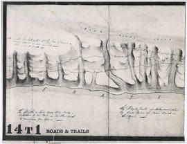
Unidentified portion of Fraser River shoreline
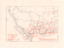
Unemployment relief works under Department of National Defence, Canada : British Columbia and Alberta

Transit system map of Greater Vancouver, B.C.

Transit system map of Greater Vancouver, B.C.

Transit system map of Greater Vancouver, B.C.
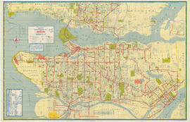
Transit system map of Greater Vancouver

Transit system map of Greater Vancouver
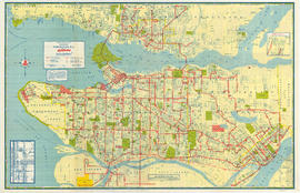
Transit system map of Greater Vancouver

Transit routes in downtown area Vancouver, B.C. effective July 18, 1952

Town-site of Hastings

Town of Granville, Burrard Inlet, B.C.

Tourist map of Greater Vancouver

Tourist guide map of Vancouver City and park

Tourist guide map of Vancouver City and Park
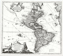
Totius Americae
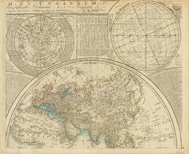
Top right plate
Top right plate

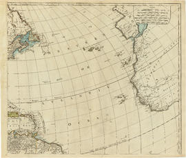
Top left plate
Top left plate

Tidal current charts, Vancouver Harbour, British Columbia : front cover

Tidal current charts, Vancouver Harbour : inside front cover

Tidal current chart, Vancouver Harbour : two hours before maximum flood at First Narrows

Tidal current chart, Vancouver Harbour : two hours before maximum ebb at First Narrows

Tidal current chart, Vancouver Harbour : two hours after maximum flood at First Narrows

Tidal current chart, Vancouver Harbour : two hours after maximum ebb at First Narrows

Tidal current chart, Vancouver Harbour : three hours after maximum flood at First Narrows

Tidal current chart, Vancouver Harbour : three hours after maximum ebb at First Narrows

Tidal current chart, Vancouver Harbour : one hour before maximum flood at First Narrows

Tidal current chart, Vancouver Harbour : one hour before maximum ebb at First Narrows

Tidal current chart, Vancouver Harbour : one hour after maximum flood at First Narrows

Tidal current chart, Vancouver Harbour : one hour after maximum ebb at First Narrows

Tidal current chart, Vancouver Harbour : maximum flood at First Narrows

Tidal current chart, Vancouver Harbour : maximum ebb at First Narrows

Tidal current chart, Vancouver Harbour : inside back cover

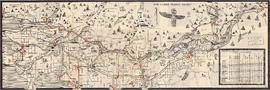
Through the Canadian Pacific Rockies : a large scale map of the mountains from Calgary to Sicamous : map cover

Through the Canadian Pacific Rockies : a large scale map of the mountains from Calgary to Sicamous : inside map cover
![[Third section of] Shaughnessy Heights](/uploads/r/null/b/9/c/b9c97036cadac8b6ffc53f2380c1c158d767da3473d29ad1b04968cc742d132e/0301116d-9946-489d-a272-9d6453523103-MAP331_142.jpg)
[Third section of] Shaughnessy Heights

The service route to - from - through industrial southwestern British Columbia
![The Seechelt [Sechelt] Forest](/uploads/r/null/e/6/d/e6d1e8d1a7613c8e7ce050434f42ef80f8e00ca339edc6e23dc578f9a4154957/c9ad5fbf-94a8-4925-8b43-b0845d5bd699-MAP54_142.jpg)
The Seechelt [Sechelt] Forest
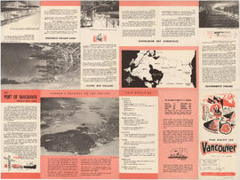
The Port of Vancouver, British Columbia

The Municipality of South Vancouver
The lower Fraser Valley

The Estate of Joseph Martin, K.C., MP
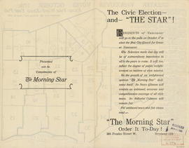
The civic election - and "The Star"!

The civic election - and "The Star"!

The city of Vancouver, British Columbia

The Canadian Pacific Rockies

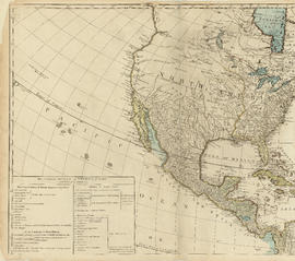
The asiatic part of the Russian empire
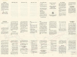
Target area civil defence survival instructions