
British Columbia - Vancouver skyline
![Fishing boats at Prince Rupert [docks]](/uploads/r/null/5/7/57cad72795de5981d5a1b74a4b6e885953b245c18485282f0028b8559053341c/2d2e9b4d-9594-40be-8441-6632a03ff306-A07220_142.jpg)
Fishing boats at Prince Rupert [docks]
![Aerial view of Ocean Falls [harbour]](/uploads/r/null/6/e/6e7b1da31432ab7db7e41f602ae5cddbf3b3c4889b489f4e532690980709637e/113f4428-192c-4424-ae49-4229a54c94ba-A03282_142.jpg)
Aerial view of Ocean Falls [harbour]
![Aerial view of Ocean Falls [harbour]](/uploads/r/null/e/f/ef9a92bc0b6b8ba55e0b9d1a94be993db8ecfc0ff976199d7aaae8bc71918c63/c6f33d55-039d-41bd-b48a-33f984667eed-A06861_142.jpg)
Aerial view of Ocean Falls [harbour]
Vancouver Harbour from Rowing Club, Stanley Park

Howe Sound : H.M.S.S. Discovery

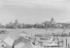
Scenes : Vancouver Harbour and skyline etc.

Scenes : Vancouver Harbour and skyline etc.
Vancouver from top of old Hotel Vancouver
![[View of] Ocean Falls [from harbour]](/uploads/r/null/a/c/ac01a62213024629cc4ad1b26c89a5bc072b7b6495192754174509e3aa713da0/d414e587-97bb-4d8e-99e2-b8f5ef2471f8-A07225_142.jpg)
[View of] Ocean Falls [from harbour]
![[View of] Victoria Harbour](/uploads/r/null/6/6/66255e20916ef61cdcddf8833e5435b5075fb8b4f1e38bb884404510b2681df9/75af0c66-cf6f-4376-aba9-e67a74aa198f-A06938_142.jpg)
[View of] Victoria Harbour
Tidal current charts : Vancouver Harbour, British Columbia
Tidal current charts : Vancouver Harbour, British Columbia
Vancouver, British Columbia. Souvenir from the lion gateway
Vancouver, British Columbia. Souvenir from the lion gateway

Vancouver Harbour, British Columbia, 1932
Along the gulf coast riviera
Along the gulf coast riviera
Vancouver Harbour : plan of south shore, Burrard Inlet between Heatley Ave. and Victoria Dr.
Vancouver Harbour : plan of south shore, Burrard Inlet between Heatley Ave. and Victoria Dr.
![[View across Coal Harbour towrds Downtown]](/uploads/r/null/d/d/ddf2d63627f742e05eab0ed197b3b40bc910fd24a176af8b9a75db9e2dd8133c/db7f74b3-f519-43e2-af80-62d88342cfea-A74506_142.jpg)
[View across Coal Harbour towrds Downtown]
Vancouver harbour

Vancouver Harbour
Privy Council (Canada) collection
Privy Council (Canada) collection
[Waterfront scene]
[Waterfront scene]
![Vancouver harbour from the roof garden [of David] Spencer's [Department] Store](/uploads/r/null/d/b/db5a883c9aac8bed679b57c2205d549efa86b2a28446fb64721146f1befa6a70/d5e169c6-2878-4aa0-ae91-fea056b71eac-CVA258-8_142.jpg)
Vancouver harbour from the roof garden [of David] Spencer's [Department] Store

Another view of Eagle Harbour
![[View of Avalon Harbor at Santa Catalina Island]](/uploads/r/null/f/d/fdf3a14b471b917b980dbdcf659078213b34df352708beb19482ea5610608647/a3fc8135-be2c-49fe-878d-0d214a9bc4d0-CVA1477-515_142.jpg)
[View of Avalon Harbor at Santa Catalina Island]
![[View of rock formation in Avalon Harbor at Santa Catalina Island]](/uploads/r/null/e/3/e3aaf19c0247951aa4bcd8b9a1f129120747587064bc56811243d6e16aa5088f/d01725e0-69c7-4546-8bd6-dcc25d9d802b-CVA1477-516_142.jpg)
[View of rock formation in Avalon Harbor at Santa Catalina Island]

Prince Rupert : misc. pix : Jack Long

Ocean Falls Harbour
![Second Narrows [on] harbour tour](/uploads/r/null/b/2/e/b2ea67536bdb443ce9ad21b9ce328068de0d7aa9252a7ea17ab7aeb9cec67c8f/78042a33-bebb-41f2-ac8e-edfa5de1b752-CVA289-266_142.jpg)
Second Narrows [on] harbour tour

Vancouver's waterfront
![BC [British Columbia] postcard - The Rockies to the Pacific](/uploads/r/null/1/2/1226936/e2a6b4cf-7e7e-48c3-8e3b-6a150d917129-MI-342_142.jpg)
BC [British Columbia] postcard - The Rockies to the Pacific
![BC [British Columbia] postcard - The Rockies to the Pacific [Japanese version]](/uploads/r/null/1/2/1226943/1fe338ae-0558-47de-bc78-ac3a556700b9-MI-343_142.jpg)
BC [British Columbia] postcard - The Rockies to the Pacific [Japanese version]
![[Southwest facing cityscape view of the West End]](/uploads/r/null/4/b/4b50b8139a75294378d4e28c633eb1a7201b7a1ffba30b79f1cf631026c1a7bd/4f7badb7-4d85-4c22-8780-a7311c11a932-A59250_142.jpg)
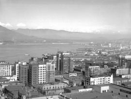
[Southwest facing cityscape view of the West End]

Spanish Bank port terminals, foreshore at Point Grey, B.C. : lands applied for and staked for development, 1909-19
![[Coal Harbour?]](/uploads/r/null/b/4/b488b986b859b20d49e5b4d6f59cb320223b0da4668774c67790e46f15e737a7/ea0b239a-5c45-449d-80f0-04a4483b3cd5-A16627_142.jpg)
[Coal Harbour?]
![[Coal Harbour?]](/uploads/r/null/1/c/1c43ca1c74017572cccbbeb20b07dae64a1d3dc2d6ed6573e3555df279535121/dee93f4d-4cde-4f0b-b504-dfb863bfa77d-A16629_142.jpg)
[Coal Harbour?]
![Burrard Viaduct Construction [2 of 10]](/uploads/r/null/5/7/57426101abc66a2ab407c951565e28bb07f8f27238a35bb05d7478ded4e540b1/8b87415b-c4bc-4c5c-bf5c-89e3546722c2-A66653_142.jpg)
Burrard Viaduct Construction [2 of 10]
Tug and barge
Tug and barge
Grain car
Grain car
Container cranes
Container cranes

Troopship from Korea, Vancouver, May 11/52
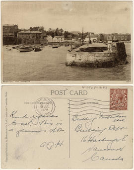
Paignton, The Harbour
The Harbour, Weymouth
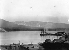
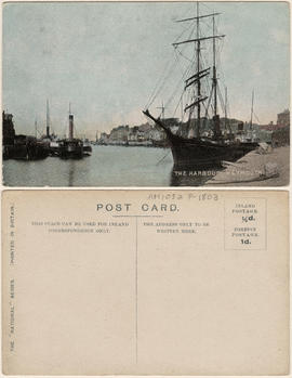
Mountain-girt Harbour

Vancouver and Stanley Park
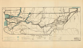
Lower Mainland Regional Plan : harbour areas

[Water front view from Burrard Inlet showing Coal Harbour, C.P.R. Pier D, Union S.S. Co. and Evans Coleman docks]

Coal Harbor Vancouver. Height of Water In Upper End 9 ft. above. Zero

Vancouver Harbor
![[360 degree view of Vancouver from the roof of the second Hotel Vancouver]](/uploads/r/null/7/2/72f205b48502a927912ec46b74aa571f102f387013c2d6bce557a2420fd72aa7/269934f7-d517-4c58-b633-4167772f935b-A63168_142.jpg)
[360 degree view of Vancouver from the roof of the second Hotel Vancouver]

[North to north east view of downtown from the Birks Building showing Burrard Inlet and the North shore in the background]