![[Last Post Association decoration service at Returned Soldiers' plot, 31st and Prince Edward]](/uploads/r/null/0/9/09b2248a1ad5aa64b05c552970179632ff63588658f6bb58db0f298dfeb3735c/ebd8f01b-1747-4478-99ed-737e84372c2e-A00600_142.jpg)
[Last Post Association decoration service at Returned Soldiers' plot, 31st and Prince Edward]
- AM1535-: CVA 99-1933
- Item
- 23 June 1929
Part of Stuart Thomson fonds
[Last Post Association decoration service at Returned Soldiers' plot, 31st and Prince Edward]
Part of Stuart Thomson fonds
![Last Post Association, memorial services [procession through burial grounds]](/uploads/r/null/2/a/2aa6f044294d2fb457923b20a5c552796f81a41c070187c4646f52796c640913/8c80fc35-b8d9-4c2c-831b-3921962bc0e7-A01581_142.jpg)
Last Post Association, memorial services [procession through burial grounds]
Part of Stuart Thomson fonds

Mausoleum for Frances C. McConnell at Ocean View Burial Park
Part of Stuart Thomson fonds
![[Ocean Park cemetery]](/uploads/r/null/e/3/e3ba8d3e3879664c3d52d8ec59d4eac0211342cefdbd3e697a18ba881d72b763/70324297-8702-4307-99ba-886429296642-A17763_142.jpg)
Part of Stuart Thomson fonds
![[Ocean View Burial Park entrance]](/uploads/r/null/c/8/c83c0aa20f44162abbfd24b9baedd85f15de20618e8a369e1dc9b11bd7a3cce1/d9b2365b-7e34-4b84-bb1d-5161e92718ab-A17765_142.jpg)
[Ocean View Burial Park entrance]
Part of Stuart Thomson fonds
![Ocean View Burial Park [Mr. Arnold, taken for Can Financiers Trust Co.]](/uploads/r/null/7/b/8/7b8d0f0132e77842d9df62d855e303c0e477a3952fdc2a6d086bed48aba64f14/99617950-be93-4b0c-86f0-f8152b9f2973-CVA99-5269_142.jpg)
Ocean View Burial Park [Mr. Arnold, taken for Can Financiers Trust Co.]
Part of Stuart Thomson fonds
![Ocean View Burial Park [Mr. Arnold, taken for Can Financiers Trust Co.]](/uploads/r/null/d/1/a/d1a04c67f496bd1a9e99791caa26ccd25ce24684267bc015b2ed88773d377849/04482c20-b662-4466-bdfb-d9e932279d16-CVA99-5269_142.jpg)
Ocean View Burial Park [Mr. Arnold, taken for Can Financiers Trust Co.]
Part of Stuart Thomson fonds
![[Ocean View Burial Park entrance]](/uploads/r/null/c/d/cd52b880ac234660dd7418fa25320c7a928ba2909ffbd4ba9e73de6ed8ee9d54/4b692a91-376c-4e79-85cb-2a28820e525c-A17846_142.jpg)
[Ocean View Burial Park entrance]
Part of Stuart Thomson fonds

Part of Stuart Thomson fonds
![Ocean View Burial Park [Mr. Arnold, taken for Can Financiers Trust Co.]](/uploads/r/null/9/7/2/972547aa56fd4020656b24f0303ed424d91bf2061d97b3a53afcba3461691712/73c59b59-0c5d-4b4d-9560-38b867479361-CVA99-5508_142.jpg)
Ocean View Burial Park [Mr. Arnold, taken for Can Financiers Trust Co.]
Part of Stuart Thomson fonds
![Ocean View Burial Park [taken for Can Financiers Trust Co.]](/uploads/r/null/0/8/c/08c954067a61e10ebcea398dd330e00f693fc2e8c8f3a800f2c3cbefba2720b1/102f7806-b94f-415c-826d-d949c4ee7e11-CVA99-5509_142.jpg)
Ocean View Burial Park [taken for Can Financiers Trust Co.]
Part of Stuart Thomson fonds
![Ocean View Burial Park [Mr. Arnold, taken for Can Financiers Trust Co.]](/uploads/r/null/2/5/8/258b83ae65f516fa94c413a2c2e7ea356edab32d5921ca443e3a8e07c0bd4fbd/18012515-2e8c-4af4-acef-eee1184480d1-CVA99-5510_142.jpg)
Ocean View Burial Park [Mr. Arnold, taken for Can Financiers Trust Co.]
Part of Stuart Thomson fonds
![Ocean View Burial Park [Mr. Arnold, taken for Can Financiers Trust Co.]](/uploads/r/null/0/2/5/025268349ec62a92f79398a56e2d8cedf121949d2d79eac2c12e1aea1c92b196/4c16d8ec-cde7-42f6-a4f8-fbeac59b86a0-CVA99-5511_142.jpg)
Ocean View Burial Park [Mr. Arnold, taken for Can Financiers Trust Co.]
Part of Stuart Thomson fonds
![Mr. McConachie - Grave at Oceanview Cemetery [Grave covered in flowers]](/uploads/r/null/a/e/8/ae81061cd1ef0d04707cb676f053b81553d030dfb979a4f4458f81589c491e1f/fa6d5ef4-e437-4712-aa10-6e190befe350-CVA99-7710_142.jpg)
Mr. McConachie - Grave at Oceanview Cemetery [Grave covered in flowers]
Part of Stuart Thomson fonds

Mr. Alton - Flowers on Wright grave, Oceanview Cemetery
Part of Stuart Thomson fonds
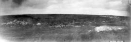
Part of Major Matthews collection
Photograph shows Vimy Ridge
Part of Major Matthews collection
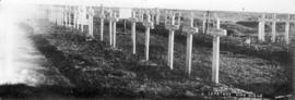
Photograph shows wooden crosses and graves of members the 54th Battalion Canadian Infantry
![Cemetery [at] Villers-au-Bois](/uploads/r/null/6/3/63923d81aef3535ca39b302f10ed21bf7b3d10b445a23c0feade6e6058b4164c/41dc6d9b-9708-4f9d-a545-1a2c3d5cb262-A26202_142.jpg)
Part of Major Matthews collection
Photograph shows the wodden crosses and graves of members of the 54th Battalion Canadian Infantry
![[Graveyard on Indian Reserve, North Vancouver]](/uploads/r/null/b/0/b081b0a4ffac356d69740ecfcd16ce2bbf2fc1b3bd008ce958b21a26502381b9/50a909bb-ec01-4286-9be8-ed120d090838-A08064_142.jpg)
[Graveyard on Indian Reserve, North Vancouver]
Part of Major Matthews collection
Photograph shows grave stones and monuments in foreground and forest and mountain peaks in the distance.
![[Elks rest monument in] a Detroit cemetery](/uploads/r/null/5/9/591f6deb70cc63f780321089794543271aee91157eb2ea5d1603d5a0ecaead9f/8ba8532c-85ee-43c0-93ae-17b72d782270-A26606_142.jpg)
[Elks rest monument in] a Detroit cemetery
Part of Major Matthews collection
![[Chapel in Detroit cemetery]](/uploads/r/null/9/a/9a1bee42ba8d99e1497622c150c1efeaa4e14200f0be09129f46d28d772a89fe/25da4155-e5fa-4a12-ade8-67b30bb6e58a-A26608_142.jpg)
Part of Major Matthews collection
![[Sheet 51 : Ontario Street to Inverness Street and Thirty-seventh Avenue to Twenty-eighth Avenue]](/uploads/r/null/3/a/3aee300fe6dd39cf02ce71f3cbf8199220cf19dc59148fcf8db71a0bdc7f8239/c1783bd2-c47b-43ed-a71d-29571b121241-MAP339_142.jpg)
[Sheet 51 : Ontario Street to Inverness Street and Thirty-seventh Avenue to Twenty-eighth Avenue]
Part of City of Vancouver Archives technical and cartographic drawing collection
Item is a sectional map of a portion of Vancouver showing the area from Ontario Street to Inverness Street and Thirty-seventh Avenue to Twenty-eighth Avenue. Includes streets, blocks, lots and legal descriptions, and the locations of parks, schools and Mountainview Cemetery.
![[Sheet 59 : Quebec Street to Inverness Street and Forty-seventh Avenue to Thirty-seventh Avenue]](/uploads/r/null/0/1/015bc0f349dc1228105d4cdd774354b22820bad860e0a822b707d62c3eb343f5/b9fe9076-66e5-4167-b081-e65e8b625778-MAP339_142.jpg)
[Sheet 59 : Quebec Street to Inverness Street and Forty-seventh Avenue to Thirty-seventh Avenue]
Part of City of Vancouver Archives technical and cartographic drawing collection
Item is a sectional map of a portion of Vancouver showing the area from Quebec Street to Inverness Street and Forty-seventh Avenue to Thirty-seventh Avenue. Includes streets, blocks, lots and legal descriptions, and the locations of parks, schools and Mountainview Cemetery.

Sheet 51 : Ontario Street to Inverness Street and Thirty-seventh Avenue to Twenty-eighth Avenue
Part of City of Vancouver Archives technical and cartographic drawing collection
Item is a section showing the area from Ontario Street to Inverness Street and Thirty-seventh Avenue to Twenty-eighth Avenue. Includes streets, blocks, lots and legal descriptions, and the locations of parks, schools and Mountainview Cemetery.
Vancouver (B.C.). Engineering Services

Sheet 59 : Quebec Street to Inverness Street and Forty-seventh Avenue to Thirty-seventh Avenue
Part of City of Vancouver Archives technical and cartographic drawing collection
Item is a section showing the area from Quebec Street to Inverness Street and Forty-seventh Avenue to Thirty-seventh Avenue. Includes streets, blocks, lots and legal descriptions, and the locations of parks, schools and Mountainview Cemetery.
Vancouver (B.C.). Engineering Services

Sheet 76 : Kerr Street to Mondy Avenue and Asquith Avenue to Forty-ninth Avenue
Part of City of Vancouver Archives technical and cartographic drawing collection
Item is a section showing the area from Kerr Street to Mondy Avenue and Asquith Avenue to Forty-ninth Avenue. Includes streets, blocks, lots and legal descriptions, and the locations of schools, parks and cemeteries.
Vancouver (B.C.). Engineering Services

Sheet 3 : Cambie Street to St. George Street and Twenty-seventh Avenue to Thirty-eighth Avenue
Part of City of Vancouver fonds
Item is a section showing the area from Cambie Street to St. George Street and Twenty-seventh Avenue to Thirty-eighth Avenue. Map shows streets, roads, blocks, lots and legal descriptions and the locations of parks, schools, reservoirs and Mountainview Cemetery. Map is hand coloured to show tax sale property for sale, property with no water, street widening and drainage, replotting, reserved land for schools, reserved land for parks, sundry land, capital assets not including schools and parks, schools, and parks, as applicable.
Vancouver (B.C.). Office of the City Engineer

Sheet 4 : Prince Edward Street to Bruce Street and King Edward Avenue to Thirty-sixth Avenue
Part of City of Vancouver fonds
Item is a section showing the area from Prince Edward Street to Bruce Street and King Edward Avenue to Thirty-sixth Avenue. Map shows streets, roads, blocks, lots and legal descriptions, and the locations of parks, schools and Mountainview Cemetery. Map is hand coloured to show tax sale property for sale, property with no water, street widening and drainage, replotting, reserved land for schools, reserved land for parks, sundry land, capital assets not including schools and parks, schools, and parks, as applicable.
Vancouver (B.C.). Office of the City Engineer

Sheet 7 : Cambie Street to St. George Street and Thirty-seventh Avenue to Forty-eighth Avenue
Part of City of Vancouver fonds
Item is a section showing the area from Cambie Street to St. George Street and Thirty-seventh Avenue to Forty-eighth Avenue. Includes streets, roads, blocks, lots, legal descriptions, parks, cemeteries, and schools. Map is hand coloured to show tax sale property for sale, property with no water, street widening and drainage, replotting, reserved land for schools, reserved land for parks, sundry land, capital assets not including schools and parks, schools, and parks, as applicable.
Vancouver (B.C.). Office of the City Engineer

Sheet 8 : Prince Edward Street to Bruce Street and Thirty-fifth Avenue to Forty-seventh Avenue
Part of City of Vancouver fonds
Item is a section showing the area from Prince Edward Street to Bruce Street and Thirty-fifth Avenue to Forty-seventh Avenue. Includes streets, roads, blocks, lots, legal descriptions, and cemeteries, parks and schools. Map is hand coloured to show tax sale property for sale, property with no water, street widening and drainage, replotting, reserved land for schools, reserved land for parks, sundry land, capital assets not including schools and parks, schools, and parks, as applicable.
Vancouver (B.C.). Office of the City Engineer

Sheet S.V. 2 : Cambie Street to St. George Street and Twenty-eighth Avenue to Thirty-eighth Avenue
Part of City of Vancouver Archives technical and cartographic drawing collection
Item is a section showing the area from Cambie Street to St. George Street and Twenty-eighth Avenue to Thirty-eighth Avenue. Map shows streets, roads, blocks, lots and legal descriptions and the locations of parks, schools, reservoirs and Mountainview Cemetery. Annotations in pencil.
Vancouver (B.C.). Office of the City Engineer

Sheet S.V. 3 : Cambie Street to Prince Edward Street and Thirty-ninth Avenue to Fiftieth Avenue
Part of City of Vancouver Archives technical and cartographic drawing collection
Item is a section showing the area from Cambie Street to Prince Edward Street and Thirty-ninth Avenue to Fiftieth Avenue. Map shows streets, roads, blocks, lots and legal descriptions, and the locations of parks, schools, golf courses and Mountainview Cemetery.
Vancouver (B.C.). Office of the City Engineer

Sheet S.V. 6 : Prince Edward Street to Bruce Street and King Edward to Thirty-fifth Avenue
Part of City of Vancouver Archives technical and cartographic drawing collection
Item is a section showing the area from Prince Edward Street to Bruce Street and King Edward to Thirty-fifth Avenue. Includes streets, roads, blocks, lots, legal descriptions, parks, cemeteries, and schools. Annotations in ink and pencil.
Vancouver (B.C.). Office of the City Engineer

Sheet S.V. 7 : Prince Edward Street to Argyle Street and Thirty-fifth Avenue to Forty-seventh Avenue
Part of City of Vancouver Archives technical and cartographic drawing collection
Item is a section showing the area from Prince Edward Street to Argyle Street and Thirty-fifth Avenue to Forty-seventh Avenue. Includes streets, roads, blocks, lots, legal descriptions, parks, cemeteries, and schools.
Vancouver (B.C.). Office of the City Engineer

Sheet S.V. 3 : Cambie Street to St. George Street and Twenty-seventh Avenue to Thirty-eighth Avenue
Part of City of Vancouver Archives technical and cartographic drawing collection
Item is a section showing the area from Cambie Street to St. George Street and Twenty-seventh Avenue to Thirty-eighth Avenue. Map shows streets, roads, blocks, lots and legal descriptions and the locations of parks, schools, reservoirs and Mountainview Cemetery.
Vancouver (B.C.). Office of the City Engineer

Sheet 4 : Prince Edward Street to Bruce Street and King Edward Avenue to Thirty-sixth Avenue
Part of City of Vancouver Archives technical and cartographic drawing collection
Item is a section showing the area from Prince Edward Street to Bruce Street and King Edward Avenue to Thirty-sixth Avenue. Map shows streets, roads, blocks, lots and legal descriptions, and the locations of parks, schools and Mountainview Cemetery.
Vancouver (B.C.). Office of the City Engineer

Sheet 7 : Cambie Street to St. George Street and Thirty-seventh Avenue to Forty-eighth Avenue
Part of City of Vancouver Archives technical and cartographic drawing collection
Item is a section showing the area from Cambie Street to St. George Street and Thirty-seventh Avenue to Forty-eighth Avenue. Includes streets, roads, blocks, lots, legal descriptions, parks, cemeteries, and schools.
Vancouver (B.C.). Office of the City Engineer

Sheet 8 : Prince Edward Street to Bruce Street and Thirty-fifth Avenue to Forty-seventh Avenue
Part of City of Vancouver Archives technical and cartographic drawing collection
Item is a section showing the area from Prince Edward Street to Bruce Street and Thirty-fifth Avenue to Forty-seventh Avenue. Includes streets, roads, blocks, lots, legal descriptions, and cemeteries, parks and schools.
Vancouver (B.C.). Office of the City Engineer
![Everest - CR [camera roll] 20-22](/uploads/r/null/1/2/1227457/469fb2a0-3151-45ca-8107-b0df2ecceb14-MI-335_142.jpg)
Everest - CR [camera roll] 20-22
Part of Yaletown Productions Inc. fonds
Film is original raw footage for the film "Everest - climb for hope." Camera: Collier/Gibson Sound: Noble/Morrow.
![Everest - PM 1 [and] 3-10](/uploads/r/null/1/2/1227428/3cbcda5b-4d84-44b0-a0f5-5ca2daaae18a-MI-336_142.jpg)
Part of Yaletown Productions Inc. fonds
Film is original raw footage for the film "Everest - climb for hope." Camera: Collier/Gibson Sound: Noble/Morrow.
![[View of graveyard where Captain Vancouver is buried]](/uploads/r/null/f/e/fecc9f7894fefd3ca091e8d6739ee7daf2fd0b6ff09436114c33873876ac45b6/9e7b4ff4-ec36-4acd-b4f2-99056ece7932-A10315_142.jpg)
[View of graveyard where Captain Vancouver is buried]
Part of Major Matthews collection
![[Captain George Vancouver's grave]](/uploads/r/null/b/8/b8f71188ba2acdca47e0d863a56829aad41787772a1576aff7056e541c946539/b7db2975-5739-465b-8f72-a2aaf3fbeee5-A10317_142.jpg)
[Captain George Vancouver's grave]
Part of Major Matthews collection
![[Captain George Vancouver's grave]](/uploads/r/null/3/a/3abd23333da5ce869450e01ec63aa4f3f25e5f2ae08a4f636f67da5fdc43bf0b/aa67e332-6660-4dfe-9651-b5c83d908027-A10318_142.jpg)
[Captain George Vancouver's grave]
Part of Major Matthews collection
![[Captain George Vancouver's grave]](/uploads/r/null/6/d/6d7b215591cd0583c618e1fc4b0c4999d7a258975c5e8419ac5f53642b6e0c01/8496ec31-5363-45a4-bafe-478edddb2fab-A09259_142.jpg)
[Captain George Vancouver's grave]
Part of Major Matthews collection
![[Presbyterian church and graveyard]](/uploads/r/null/4/7/47442b1cdc14db0667fc82b67dc27dcee7f08492c344150e9e149e02145acd49/ea3fe350-9f79-4601-b23f-af63dd15bef5-A33469_142.jpg)
[Presbyterian church and graveyard]
Part of Major Matthews collection
![[Mrs. Nellie Evans at her son's grave in Mountain View Cemetery]](/uploads/r/null/e/0/e07000f7d14eaaf73816517c0947be4c06bc79dc3808bab928422e11bd1ce7ff/cb182b52-df6b-4eec-8fe2-16b3c0f09d28-A09450_142.jpg)
[Mrs. Nellie Evans at her son's grave in Mountain View Cemetery]
Part of Major Matthews collection
Caradoc Evans, son of David and Nellie Evans, was the first burial on the grounds of Mountain View Cemetery in 1887. J.S. Matthews' notes with print or negative in Archives.
![[Mrs. Nellie Evans at her son's grave in Mountain View Cemetery]](/uploads/r/null/b/2/b2d7ed20a58135027965e70805c4afbece928ecb45321927965c46cc25398eee/112ccd7e-a6f9-48a7-b480-4d15fc50bd1f-A09452_142.jpg)
[Mrs. Nellie Evans at her son's grave in Mountain View Cemetery]
Part of Major Matthews collection
Caradoc Evans, son of David and Nellie Evans, was the first burial on the grounds of Mountain View Cemetery in 1887. J.S. Matthews' notes with print or negative in Archives.
![[Grave of Caradoc Evans in Mountain View Cemetery]](/uploads/r/null/f/3/f37de92889665fb1573eeaf164bda54bc4354b65eaf050dcbef444bf9797b825/c65086c2-eb25-4c8e-8fb6-83f4236032a9-A09453_142.jpg)
[Grave of Caradoc Evans in Mountain View Cemetery]
Part of Major Matthews collection
Caradoc Evans , son of David and Nellie Evans, was the first burial on the grounds of Mountain View Cemetery in 1887. J.S. Matthews' notes with print or negative in Archives.
![[Mrs. Nellie Evans at her son's grave in Mountain View Cemetery]](/uploads/r/null/d/5/d5087b8bbc53437e7390002d180f51548fc48bc3452d6d37d743905fda0b3f54/1d0823dd-c212-447d-8058-09b266a0116a-A09454_142.jpg)
[Mrs. Nellie Evans at her son's grave in Mountain View Cemetery]
Part of Major Matthews collection
Caradoc Evans, son of David and Nellie Evans, was the first burial on the grounds of Mountain View Cemetery in 1887. J.S. Matthews' notes with print or negative in Archives.
![[Mrs. David Evans at her son's grave in Mountain View Cemetery]](/uploads/r/null/b/2/b25848cf4f5dd22f7493610b717e7388f41f70175399f2e7819689b10955f1a3/7b760902-8612-4e0a-a7d0-8d2ca96735c5-A09455_142.jpg)
[Mrs. David Evans at her son's grave in Mountain View Cemetery]
Part of Major Matthews collection
Caradoc Evans, son of David and Nellie Evans, was the first burial in Mountain View Cemetery in 1887. J.S. Matthews' notes with print or negative in Archives.