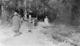
![[A trail through the trees]](/uploads/r/null/1/5/d/15ded62fcf1ee54afe9b0f16a24362fac6ca5b7564ffedd067ef08bdc86682d5/36272c2d-f2c7-449b-9bc9-ed2038b6d244-CVA260-1899_142.jpg)
- AM640-S1-: CVA 260-1899
- Item
- [193-?]
Part of James Crookall fonds
158 results with digital objects Show results with digital objects
Part of James Crookall fonds
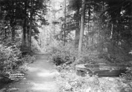
![[A trail through the trees]](/uploads/r/null/d/6/9/d6927b35b6897ce0028bc35a8302cc3df8ab4984ab6a1db052fc7fd091e2f01f/587be8c9-9de7-4b41-b54d-4f81faf231f1-CVA260-1901_142.jpg)
Part of James Crookall fonds
![[A trail through the trees]](/uploads/r/null/e/e/7/ee743d429100b867a3c3a5dff47638a40a681b86d0702f48a598631bd40bc15f/82c3cf55-2616-49fc-baf0-2b5651de462d-CVA260-1990_142.jpg)
Part of James Crookall fonds

Rustic bridge. Stanley Park, Vancouver, B.C.
Part of Major Matthews collection

Sketch map of part of British Columbia showing trails and routes of communication
Part of Major Matthews collection
Item is a photostatic copy of a manuscript map showing trails and routes of communication in a portion of British Columbia from the Canada-U.S. border in the south to Seaton Lake in the north, and from the coast to Vermillion in the east. The section of coastline extends from Semiahmoo Bay in the south to Point Atkinson in the north. Map shows the location of mule trails and wagon roads, and includes a trail in progress from New Westminster to Burrard Inlet (North Road), trails from Whatcom to Hope and Semiahmoo to Derby, the Hudsons Bay Brigade Trail, Douglas Road, a trail proposed by Colonel Moody from New Westminster to Fort Hope, and the Dewdney Trail. Included with the map is a 1949 letter from Major Matthews, City Archivist, to J.M. Pearce in which Matthews describes the map, and a 1952 enquiry from L.B. [Housler] for a map showing the Dewdney Trail.
![[Benches along trail in Stanley Park]](/uploads/r/null/b/7/b70ae5952d325b9baa97932b8529f242a0c270b869a92d2a06faa0aec19c313b/ebb77758-01cf-47f4-8211-b426d692f9b9-A08069_142.jpg)
[Benches along trail in Stanley Park]
Part of Major Matthews collection
J.S. Matthews' notes with print or negative in Archives.
![[Man seated at edge of path leading to St. Alice Hotel, Harrison Hot Springs]](/uploads/r/null/2/e/2e934fe9d54768bb9d1e1a0a33a533bc0881d9fa4d70d14ba790e28c0bb9a5e1/51c9c96b-c0e2-411f-b0e5-c8c179f2176b-A04506_142.jpg)
[Man seated at edge of path leading to St. Alice Hotel, Harrison Hot Springs]
Part of Major Matthews collection
J.S. Matthews' notes with print or negative in Archives.
![Entrance to Johnson [Johnston] Canyon](/uploads/r/null/9/2/4/924e516b931d72d95ca1b8265bc71d865114b2eadbf2c29b563fe55b76e3b9bd/b6cf2ebf-66ef-43d9-b8a0-50d983de2bd7-CVA289-003_142.jpg)
Entrance to Johnson [Johnston] Canyon
Part of William Orson Banfield fonds
![The trail through the [Johnston] canyon](/uploads/r/null/9/7/3/973281bf3d30da936ddd7873e1c4b8dd62c03e8bde11a41fc4c9478206363e85/ec594cc6-0201-4506-b5ed-8d7a4a6263c1-CVA289-003_142.jpg)
The trail through the [Johnston] canyon
Part of William Orson Banfield fonds
![Trip to the glacier at the foot of Mt. Baker : The woods on trail to Church M[oun]t[ain]](/uploads/r/null/3/7/f/37f526dc173e1232aece1fff7a8a7de6576f1f6c2b40ae4a68290ef239dce02c/380093d7-b917-46d1-9ffb-85cf5518e0c1-CVA289-003_142.jpg)
Trip to the glacier at the foot of Mt. Baker : The woods on trail to Church M[oun]t[ain]
Part of William Orson Banfield fonds
Item is a photograph showing two men on a hike. Album page contains a list of names of those who took part in the trip: Art Lord, Mr. and Mrs. Lord, Sherwood Lett, W.O. Banfield, Mr. and Mrs. T.S. Baxter, Mr. and Mrs. W.E. Baxter.

Part of William Orson Banfield fonds

Part of William Orson Banfield fonds
Our picnic at the Goldstream, Easter
Part of William Orson Banfield fonds
![One of the trails back of the [Grouse Mountain] chalet](/uploads/r/null/d/d/5/dd52f3b0be55d69bdfabeacc5278295efdc80b770368dc9535d45240928a824c/802bf332-31fc-49b0-a72c-fb102f9cce9a-CVA289-004_142.jpg)
One of the trails back of the [Grouse Mountain] chalet
Part of William Orson Banfield fonds
![China Bluff on way to Boston Bar - Frazer [Fraser] River](/uploads/r/null/7/b/7bd123659bbb4dc0aa3970fe573df39cbf2f6b12f7e5747300a89968847289cf/51f452e5-0b09-4380-a408-9ad604c969d5-A22917_142.jpg)
China Bluff on way to Boston Bar - Frazer [Fraser] River
Part of Major Matthews collection
![[Walking path among tall trees in] Stanley Park](/uploads/r/null/9/a/9a02898b2c2540212f2608674f50e96d5d748c3e599f0685fe5ada783f933e57/429483b9-e3fd-4b6f-94f2-907ab88d6566-A01898_142.jpg)
[Walking path among tall trees in] Stanley Park
![[Walking path in] Stanley Park](/uploads/r/null/a/f/af2bacb1763ef13315ea9ab1855d4785051a0c405c8ac6a6c51771dd82bc0b64/e017f734-4629-4a1e-8067-42487b96e4a0-A01897_142.jpg)
[Walking path in] Stanley Park
Photographs in album show various areas and scenes in Stanley Park, including: entrance bridge, a path next to a gazebo, a picnic area among trees, the road to the resevoir, a group assembled in a clearing, a pedestrian bridge, the seal pond, a wooded area, a boat in Coal Harbour, a dirt road, a horse-drawn buggy crossing a wooden bridge, a moss grove, Hallelujah Point, a walking path, a beach, and a view of the surf.

Road to reservoir, Stanley Park
Photograph shows woman standing at wooden gate on a path through the trees.
![[Walking path]](/uploads/r/null/b/9/b90a505ee14f258a5cfe66d6d1b58f8f69da984139e043efdbe5bc0cbd401347/b96a8dca-3915-4b90-8083-c9b6a7dfa4e4-A01980_142.jpg)
Photograph shows a man standing on a wide path through a forested area.
![[Forest path by gazebo]](/uploads/r/null/e/9/e9137bf721bea15ecbf4ccb83f9a84ae3982f366414e560ae19db9a13ce0a8ac/a0f75382-b264-4563-a550-829de6776894-A01968_142.jpg)
Photograph shows a wide path through the trees next to a small gazebo.
![Arbutus Point [Bowen Island] 5 August 1926](/uploads/r/null/a/6/a6ec7fe065c375319185bf1cef6883f7d0440ea71ffacfb5a5e564ec307aface/92bf4f18-0276-4196-810b-8ed847e516eb-A02048_142.jpg)
Arbutus Point [Bowen Island] 5 August 1926
Photograph shows a trail through the woods.
![[Man and woman on horseback at Stanley Park trail]](/uploads/r/null/6/1/61bca704acddd2925838958fe6c43d3dbbd87911cc0bda8b32f5ea42f131d238/adc3fdf9-e67e-45e5-9a71-b58ddd5a861b-A02319_142.jpg)
[Man and woman on horseback at Stanley Park trail]
![[Intersection of two paths next to lake]](/uploads/r/null/d/7/d760c01663f15e6f1af48e61a82c1af04d6197b8648a69bf35efaee558f51a4f/c4f37f4c-993b-4d6e-adda-72cfecbc7cac-A02393_142.jpg)
[Intersection of two paths next to lake]
A note on the original accompanying envelope reads: "Stanley Park, a driveway, a pathway, and a tree."
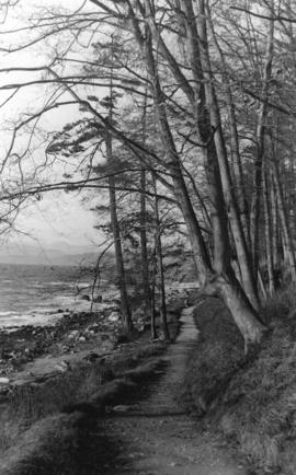
Cedar walk, Stanley Park, Vancouver, B.C.
Attached label reads: "Thirty-seven years ago in Stanley Park. Along the trail to 3rd Beach, about 150 feet west of the clump of Fir trees called the Seven Sisters. This is the remains of an Indian dug-out canoe that was abandoned on account of "dry rot" in the log. What is left of it is covered with dense green moss. The newly chopped chips were lying about when I made the above photograph. Philip Timms."
![[Trails] in Stanley Park, Vancouver, B.C.](/uploads/r/null/e/a/eae326b821e014fff2152e0948757e49814aa6172b661cd072416eb85c2cd178/307cb3b4-f947-4a09-9159-38680a607180-A02831_142.jpg)
[Trails] in Stanley Park, Vancouver, B.C.
Photograph shows an intersection of trails, surrounded by trees and shrubs.
![[Snow-covered trees and path in Stanley Park]](/uploads/r/null/e/b/ebb3146784d3bceef350586c11bfac5d2f98e80fa102bed897651602b161b358/58bcffaa-3b59-4692-87b9-de753fb5760d-A02300_142.jpg)
[Snow-covered trees and path in Stanley Park]
![[Snow-covered trees and trail in Stanley Park]](/uploads/r/null/3/3/338b72131ed7ad44e8d79092d193d2a49236ddd118eb855ffac537563959c7b5/d7714a77-d89d-42d1-88b9-1d6e56b4c968-A02302_142.jpg)
[Snow-covered trees and trail in Stanley Park]
![[Sun shining on trees and trail in Stanley Park]](/uploads/r/null/a/c/ac09cdb852145a6cb7cab240ecf290cc6da15025bfb06ffe48e71fad8affff8d/4cec3db9-3041-4102-87f4-608857193ab8-A02303_142.jpg)
[Sun shining on trees and trail in Stanley Park]
![[Walking path in Stanley Park, surrounded by trees and ferns]](/uploads/r/null/6/a/6a02fa01b89bd9e64dc8860eff82e1cc122389f3ec9f3766e543f4095fb19bb6/2f46a38b-bd05-4e52-b462-e10837340dcc-A02304_142.jpg)
[Walking path in Stanley Park, surrounded by trees and ferns]

![[Trees and path in Stanley Park]](/uploads/r/null/4/0/409d9957d536449c8af4b0c319f8e89ecca52a43bcee5efa472996c56469bdbc/abe4c59e-0a6e-4e2b-be62-b5e8b1b70574-A02299_142.jpg)
[Trees and path in Stanley Park]
![[Pedestrian and equestrian paths in Stanley Park]](/uploads/r/null/8/3/83a243e5a3de71d2b7444225994b3426698fc8a6c4ea7bdc87f5d72790553386/c78fa8b3-904b-4f42-a262-cf821908634f-A02311_142.jpg)
[Pedestrian and equestrian paths in Stanley Park]
Photograph shows two paths, side by side, separated by a wooden railing. Two men on horseback are on the left path, and a man and boy are on the right path.
![[View of path and beach at] Stanley Park](/uploads/r/null/3/a/3aa0c6077e47f7d0def9ff0528c568c8ca0459362557f2b3add0ac28e18c5e09/64890d47-0b29-4866-85df-e15fdc45b171-A02314_142.jpg)
[View of path and beach at] Stanley Park
![[Snow-covered trail in Stanley Park]](/uploads/r/null/a/a/aa7f30d111c46b5900cd46ec0668aaea038c6862eecce7b96c5d5f54fb646f29/2487dfba-f60c-4fb0-bd51-35ce5502694a-A02322_142.jpg)
[Snow-covered trail in Stanley Park]

Photograph shows a walking path in Stanley Park near the first narrows of the Burrard Inlet.


Path next to an inlet with a building on the shore in the background
Part of Stuart Thomson fonds

Path toward a dock with a boat tied up
Part of Stuart Thomson fonds
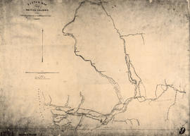
Sketch map of part of British Columbia showing trails and routes of communication
Part of Major Matthews collection
Item is a photostatic copy of a manuscript map showing trails and routes of communication in a portion of British Columbia from the Canada-U.S. border in the south to Seaton Lake in the north, and from the coast to Vermillion in the east. The section of coastline extends from Semiahmoo Bay in the south to Point Atkinson in the north. Map shows the location of mule trails and wagon roads, and includes a trail in progress from New Westminster to Burrard Inlet (North Road), trails from Whatcom to Hope and Semiahmoo to Derby, the Hudsons Bay Brigade Trail, Douglas Road, a trail proposed by Colonel Moody from New Westminster to Fort Hope, and the Dewdney Trail. Included with the map is a 1949 letter from Major Matthews, City Archivist, to J.M. Pearce in which Matthews describes the map, and a 1952 enquiry from L.B. [Housler] for a map showing the Dewdney Trail.
Old pack trails in the proposed Cascade wilderness
Item includes membership application to Okanagan Similkameen Parks Society, Summerland, B.C.
![[Trail along beach in Stanley Park]](/uploads/r/null/8/8/88bcab166e61dd7d1c620d8ecb464e199095d0d2e6fe25fa9f2a25fb7c85a0f1/01624d79-0f60-4b15-b59b-a28f39cd7707-A02572_142.jpg)
[Trail along beach in Stanley Park]
![[Woman at wooden staircase near path, Stanley Park]](/uploads/r/null/4/5/457c89c6028bf23763596d6fdc697d21ae95ab0da8b9e499329612e0e3d1d93d/2e27cf54-52d9-4482-9bfd-70bb3ab160bb-A04017_142.jpg)
[Woman at wooden staircase near path, Stanley Park]
Part of Major Matthews collection
J.S. Matthews' notes with print or negative in Archives.
![[Men and women standing on trail at Stanley Park]](/uploads/r/null/f/a/fa6f5f79acc7cf977815f3356d745b18c689f6d293be9af218c2b3b39c02472b/4c70017d-7acc-47ee-863d-869539dd7633-A04021_142.jpg)
[Men and women standing on trail at Stanley Park]
Part of Major Matthews collection
J.S. Matthews' notes with print or negative in Archives.

Winter in the park, Vancouver, B.C.
Part of Major Matthews collection
Photograph shows a man walking down a snow covered trail.

Part of Major Matthews collection
Photograph is a copy of the two photographs of forest scenes in Stanley Park.

Part of Major Matthews collection
Photograph is a copy of two photographs of forest scenes in Stanley Park.
!["Morning, and a sheen of silvery mist". Stanley P[ar]k. Van., B.C. and "Quarrellin...](/uploads/r/null/b/b/bb31dc05c734b3129e139e5da0a4619420df00f5bb0ff194ef6ed6d4c54a157e/13b22f1c-0217-4b10-8e72-6b9c9a9b9952-A04477_142.jpg)
Part of Major Matthews collection
Photograph is a copy of two photographs showing forest scenes in Stanley Park.