
Burwell Lake, view of Crib Dam looking north
- AM1257-S25-: CVA 275-25
- Item
- Mar. 5, 1926
372 results with digital objects Show results with digital objects
Burwell Lake, view of Crib Dam looking north
Burwell Lake, view of Dam face after completion of repairs
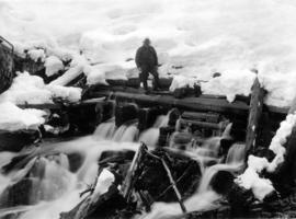
Burwell Lake, view of Spillway Dam showing leaks
![[Capilano Creek Dam]](/uploads/r/null/a/c/ac4e509bc906b130ea5d0af6754302308993a1a1e9bfac8418dfe66e8a8a5d62/b8d53f43-f5f5-416a-bd34-239e28a01820-A25791_142.jpg)
Part of Major Matthews collection
![[Capilano Creek Dam]](/uploads/r/null/e/d/ed47628f64f1672f958233dce53864855e65ed095cbae462d201f7147d89a90e/52712de1-f51e-43b1-8d83-60ddd0d41b22-A25806_142.jpg)
Part of Major Matthews collection

Part of Major Matthews collection
![[Capilano Creek Dam]](/uploads/r/null/0/2/026d540540368258e10e4aa5138eb417505fb9aaca394f01698547c979146bcb/9dd645c8-bda0-4552-bc03-ae804570eea2-A25805_142.jpg)
Part of Major Matthews collection
![[Capilano Creek Dam]](/uploads/r/null/5/3/539f32e9bde47f8b07c4ec5d803350024643ad7bb3ca55e3b3c5f7c873eedfc7/3acfb5f2-1c80-46a6-99f3-1f38293c8c8f-A25792_142.jpg)
Part of Major Matthews collection
![[Capilano Creek Dam]](/uploads/r/null/c/4/c4f4fe8619a499ab851b052858b3c61452c4f7ccb1ee18b6fabcc825296f30fe/bebd907b-cc51-4084-a07d-c1df86feaabe-A25797_142.jpg)
Part of Major Matthews collection

Part of Major Matthews collection
Capilano Dam, Vancouver waterworks, 1907

Capilano River - where the dam is - 1906
![[Cascade Light and Power Company's dam]](/uploads/r/null/5/f/5f60beaecdb121071b52869f1291e89841192c314f5c776bf395ea7d5611cea4/1771cb4c-4d67-40b7-9454-8167386b8c07-A33319_142.jpg)
[Cascade Light and Power Company's dam]
Part of Major Matthews collection

Part of City of Vancouver Archives technical and cartographic drawing collection
Map is a topographical plan showing a proposed hydroelectric development in the Cheakamus River area, between Garibaldi Lake and Daisy Lake, and a profile along the tunnel and pipeline route. Included on the map are Daisy Lake, Garibaldi Lake, Cheakamus River, various creeks, including Parnassus Creek and Scott Creek, bluffs, and ponds. Also indicated on the map are the locations of a pipeline, tunnel and tunnel intake, the Daisy Lake Trail and other trails, a construction shaft, proposed dam, proposed Daisy Lake Reservoir, and the power station for the Garibaldi-Daisy Lake Development. The map was created to accompany E.A. Cleveland's "Report on a Preliminary Investigation of the Cheakamus River Power Possibilities made for the City of Vancouver."

Part of City of Vancouver Archives technical and cartographic drawing collection
Map is a plan showing the location of power houses, dams and pipes for the Garibaldi-Daisy Lake development, Cheakamus Lake-McGuire, McGuire-Brandywine, Cheakamus Canyon and Daisy Lake Dam areas. Map created to accompany E.A. Cleveland's "Report on a Preliminary Investigation of the Cheakamus River Power Possibilities made for the City of Vancouver."

Part of City of Vancouver Archives technical and cartographic drawing collection
Map is a plan of the proposed development of the Cheakamus Lake for hydroelectric power. Includes a capacity diagram of Cheakamus Lake with dam at section A-B and a plan of the proposed dam site. The map also shows elevations and types of terrain. Map created to accompany E.A. Cleveland's "Report on a Preliminary Investigation of the Cheakamus River Power Possibilities made for the City of Vancouver." A note on the map reads "Traverse from Sta. 257-50 to Sta. 371-10 by C.W. Williams 1923, Cheakamus Lake from plan by Williams (1923) except soundings as shown." Map has been numbered Tube 56.

Part of City of Vancouver Archives technical and cartographic drawing collection
Map is a topographical plan showing the proposed hydroelectric development on the Cheakamus River near Mile 19, Pacific Great Eastern Railway. Indicated on the map are the locations of tunnels, dams, by-passes, pipelines, the railway line, and the power station for the Cheakamus Canyon development. The map was created to accompany E.A. Cleveland's "Report on a Preliminary Investigation of the Cheakamus River Power Possibilities made for the City of Vancouver." Map has been numbered Tube 59.

Part of City of Vancouver Archives technical and cartographic drawing collection
Map is a topographical plan showing the proposed diversion works on the Cheakamus River near Mile 19, Pacific Great Eastern Railway. Indicated on the map are the locations of tunnels, dams and the railway line. The map was created to accompany E.A. Cleveland's "Report on a Preliminary Investigation of the Cheakamus River Power Possibilities made for the City of Vancouver." Map is numbered Tube 60.

Part of City of Vancouver Archives technical and cartographic drawing collection
Map is a plan of the proposed storage reservoir at Daisy Lake on the Cheakamus River. The map includes a plan of the topography of the proposed dam site, a log of borings, and a capacity diagram at Daisy Lake Reservoir. Also included are elevations, power stations, pipelines and the Pacific Great Eastern Railway line. The map was created to accompany E.A. Cleveland's "Report on a Preliminary Investigation of the Cheakamus River Power Possibilities made for the City of Vancouver." Map has been numbered Tube 58.

Part of City of Vancouver Archives technical and cartographic drawing collection
Map is a topographical plan showing the area from Alpha Lake to Cheakamus River, above Mile 34, Pacific Great Eastern Railway. Indicated on the map are the locations of the Mons Gauging Site, a suggested dam site, trails, the old wagon road, the railway line, and Millar Creek. The map was created to accompany E.A. Cleveland's "Report on a Preliminary Investigation of the Cheakamus River Power Possibilities made for the City of Vancouver." Map has been numbered Tube 61.

Part of City of Vancouver Archives technical and cartographic drawing collection
Map is a plan showing the location of power houses, dams and pipes for the Garibaldi-Daisy Lake development, Cheakamus Lake-McGuire, McGuire-Brandywine, Cheakamus Canyon and Daisy Lake Dam areas. Map created to accompany E.A. Cleveland's "Report on a Preliminary Investigation of the Cheakamus River Power Possibilities made for the City of Vancouver."
Part of City of Vancouver fonds
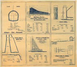
Item is an architectural drawing sheet with six drawings related to proposed hydro electric development on the Chilliwack River: Tunnel section; Spillway section-rock-filled timber crib dam at Chilliwack Lake; Tunnel intake; Tunnel outlet & surge tank; Diversion & storage dam; and Power house and tailrace. Each drawing includes cost and quantity estimates for construction materials.
![City Waterworks [Capilano Creek Dam]](/uploads/r/null/e/9/e9761177a88bcafc9c640a7180504b8df47f6cd49644720806efc6f3178d8e2b/2f2c5021-6221-40c8-bd1b-3c8ad899e761-A25796_142.jpg)
City Waterworks [Capilano Creek Dam]
Part of Major Matthews collection

City waterworks dam, Vancouver, B.C.
Part of Major Matthews collection
Part of Major Matthews collection
![[Close-up view of a portion of a hydro electric dam]](/uploads/r/null/4/c/4cfcc9054c04d687144cbafda749406c0e6db06545e2444964e2c7baf7a06f33/21625ed5-c79d-42d2-aa1c-2ab171716ceb-A13467_142.jpg)
[Close-up view of a portion of a hydro electric dam]
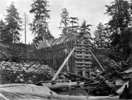
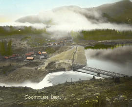
![[Construction site for Coquitlam Dam, showing construction camp, flumes and borrow pit]](/uploads/r/null/a/4/a43891ec64e689b7fc278714422f4c19d234bde6b278150239dd3f926c02800e/60f385ff-d81a-4822-a316-bed08b74bf20-A08628_142.jpg)
[Construction site for Coquitlam Dam, showing construction camp, flumes and borrow pit]
Part of Major Matthews collection

Part of Major Matthews collection
Photograph negative is a copy of a cross section diagram of the dam, showing: rock fill in upstream and downstream toes; location of original dam buried in new structure; and the equivalent cross section of a concrete dam. Negative was created in order to produce a lantern slide of the image.

Part of Major Matthews collection
Photograph shows the construction camp
Part of Major Matthews collection

Coquitlam Dam - New Westminster intake site showing clearing done around the intake
Part of Major Matthews collection
![[Coquitlam Dam construction camp and borrow pit]](/uploads/r/null/5/6/56d88b32279226a9df55b0357e3f252624b2d563461725c59c440efdeb111c39/1b9a5376-8614-4da2-8816-c38a3a406152-A08626_142.jpg)
[Coquitlam Dam construction camp and borrow pit]
Part of Major Matthews collection
![[Coquitlam Dam construction site, showing trestle and monitor in partially excavated area]](/uploads/r/null/f/7/f7860fe82f842a0d468bf0cb5604dd998f808fbd8a1a07f705a42d9a297c35dc/1a604da9-747a-49e0-b192-8cc53089f67d-A08394_142.jpg)
[Coquitlam Dam construction site, showing trestle and monitor in partially excavated area]
Part of Major Matthews collection

Coquitlam Dam entrance channel cut looking towards headworks stake
Part of Major Matthews collection

Coquitlam Dam from 2300.0 on 9th Aug. 1913
Part of Major Matthews collection
Photograph shows centre of dam near completion.

Part of Major Matthews collection

Coquitlam Dam general view of ledge exposed at Mr. Schuyler's headgates site
Part of Major Matthews collection

Coquitlam Dam headworks site as suggested by Mr. Schuyler after ledge exposed by monitors
Part of Major Matthews collection
Coquitlam Dam headworks site as suggested by Mr. Schuyler after ledge exposed by monitors
Part of Major Matthews collection

Coquitlam Dam headworks site as suggested by Mr. Schuyler after ledge exposed by monitors
Part of Major Matthews collection

Coquitlam Dam looking along the slope in the headworks entrance channel
Part of Major Matthews collection

Coquitlam Dam looking northeast
Part of Major Matthews collection
Photograph shows a view of the sluicing done for a proposed canal to sluice from south abutment of existing dam

Coquitlam Dam looking south from tunnel showing clearing
Part of Major Matthews collection

Part of Major Matthews collection
Photograph shows the sluice pit from Mr. Schuyler's headgates site
![Coquitlam Dam [showing a] view of sluicing done for proposed canal to sluice tunnel](/uploads/r/null/0/9/09eed98b248bbc0054b0324e562899a6a36950141c26037b27c305effba23957/5230f15a-3a21-4128-a2ab-3114c41441b5-A32879_142.jpg)
Coquitlam Dam [showing a] view of sluicing done for proposed canal to sluice tunnel
Part of Major Matthews collection
Photograph was taken from top of the slope at the west side of the river looking northeast
![Coquitlam Dam [showing] bed rock exposure at headworks location at the end of the entrance channe...](/uploads/r/null/5/6/56b55935aa442809c475072d37bc7a4b7e3014ac125c780d06b18bd1faaab65d/8705eaf6-282d-4f4d-846e-6e4de2cd1902-A32931_142.jpg)
Part of Major Matthews collection

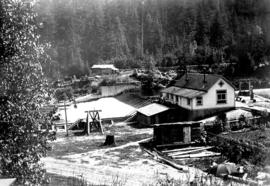
Coquitlam Dam showing contractors' tunnel camp and lower half of new dam site
Part of Major Matthews collection

Coquitlam Dam showing dam outline looking east
Part of Major Matthews collection
![Coquitlam Dam [showing] depth of water over crest of 5 feet](/uploads/r/null/d/4/d47bcf5213f11d0cad872b997d20658b59887b1b5746c2f6739f44549551b20e/757bbc67-f7bb-4ef5-9087-41efa44094d5-A32921_142.jpg)
Coquitlam Dam [showing] depth of water over crest of 5 feet
Part of Major Matthews collection
Photograph shows the new facing on the crib in front of the pump house