
City skyline from Stanley Park near Brockton Point
![[Cityscape view of downtown looking North-West]](/uploads/r/null/b/9/b95782e50593bd4e9637c37355cf72f23fab74f503462817d0f2cf4472f787c8/326767f9-9f75-4af1-aef4-d2c325cfdd3e-A58786_142.jpg)
[Cityscape view of downtown looking North-West]

Cliffhouse

Cloud scene near Ocean Falls

Clouds near Prince George

Clover Point Rifle Range
![C.M.A. [Canadian Manufacturing Association] : Malahat Drive etc.](/uploads/r/null/a/2/a/a2a6f3e541daa1b09fb40a28d39bd55946b9b886d7de558d857d8655336f3a71/53547ce1-e8e3-43ff-a7b6-4fd5ff4b7ff7-CVA586-15082_142.jpg)
C.M.A. [Canadian Manufacturing Association] : Malahat Drive etc.
![C.M.A. [Canadian Manufacturing Association] : Malahat Drive etc.](/uploads/r/null/9/6/0/960f08499243b76dec7193782b182048bb5f9ac9ed7bd23c363a2b12470fd16a/4cbfd568-9b31-4521-a630-0318094ed8aa-CVA586-15084_142.jpg)
C.M.A. [Canadian Manufacturing Association] : Malahat Drive etc.
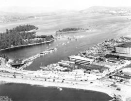
![[Coal Harbour and Downtown from the Causeway]](/uploads/r/null/d/f/5/df5783e376ce091eaa747d85bdac39ab081c295ffb29db71e675d1326a870c77/8b685d69-96da-4273-b4c4-226e0f99cfc5-CVA260-1224_142.jpg)
[Coal Harbour and Downtown from the Causeway]
Coal Harbour Vancouver, B.C.
![[Coast in northeast Scotland]](/uploads/r/null/b/e/be1ee91d022d893f74b20c2a64283c4c0652289a0bb619c287cc1f3a093d1478/ff6de4ac-9a8a-4242-b9a9-1f681715c349-A50301_142.jpg)
[Coast in northeast Scotland]

Collingwood East
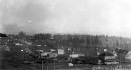
Collingwood East

Collingwood East
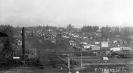
Collingwood East
![Columbia River, south from [road]](/uploads/r/null/5/6/7/5670195d2de94762b4f109d3a418369b5336f78561f2a4469b39b1832adbaec7/44846721-0d90-442b-ba11-65cdce7de47e-CVA256-02_142.jpg)
Columbia River, south from [road]
![[Composite photograph depicting the development of downtown Vancouver in ten year increments.]](/uploads/r/null/9/a/5/9a599c6180f7d9caaea4b0a04eb4a5b5827264cb9e9344369b7e06108e425d9c/06f5f827-8afe-43ef-abaf-6e7be6378a75-AM1052P-1011_142.jpg)
[Composite photograph depicting the development of downtown Vancouver in ten year increments.]

Coquitlam Dam looking north towards tunnel camp on west shore of lake showing ground cleared and ready for burning
![[C.P.R. fuel tanks near the foot of Cardero Street]](/uploads/r/null/2/5/25d045a5c71ee6055631537cf9b4d8055cf8c5aaa7538e35395fe8f871337d24/fe7903f8-69a6-4ad7-aafe-6a4095dd632d-A63068_142.jpg)
[C.P.R. fuel tanks near the foot of Cardero Street]

C.P.R. Hotel - Banff
![C.P.R. Hotel from across the Bow [River]](/uploads/r/null/d/3/d3a80de5b951f1842415374308c3a996d505e2e41da6e75237d796f48373a3c0/db67449f-16bd-482f-8c40-73bfb8fb65fa-A20027_142.jpg)
C.P.R. Hotel from across the Bow [River]
![C.P.R. Hotel from across the Bow [River]](/uploads/r/null/6/7/67123ef2c87b6798e0cfaac1f764f7e119c3b51efc66b476abcb2eee7f4e4e28/415b9b34-4136-4267-aef8-7b547e494120-A20028_142.jpg)
C.P.R. Hotel from across the Bow [River]

C.P.R. Yard

Crater from Mount Crown
![Cricketers [at Brockton Point]](/uploads/r/null/2/2/22d373d8497235c2e7858fe309bd39766e3a266ca60b37d91a706a796dbee16c/6bdf8c4d-f748-4a20-b7da-ccb71392f507-A36772_142.jpg)
Cricketers [at Brockton Point]

Crown Mountain from Prospect Point

Crown Point

Dam Lake from Goat Mountain
![Dam M[oun]t[ain] from Grouse M[oun]t[ain]](/uploads/r/null/4/6/9/4690f6cbc484d6ce3274ea1f0f8d388e2aa66569738feb76fa159fd377017a0b/ed175d58-a767-4091-8d2f-aaa9137f34ab-CVA289-038_142.jpg)
Dam M[oun]t[ain] from Grouse M[oun]t[ain]
![Deadmans Island [from the foot of Bute Street]](/uploads/r/null/0/e/0e11699ed5af3b6c22cebbb600a509e5d6e8737a11bd0b7540ac37012b4198ae/5b5a2646-60f3-47e7-8741-0f79ded561f2-A61628_142.jpg)
Deadmans Island [from the foot of Bute Street]
![Deadmans Island [from the] foot of Bute Street](/uploads/r/null/a/4/a4a775dbef3431d1699dc5c11c1a276932172549bae5d265dfdd5ef3a1b2a997/231cdbb9-d0c9-4b2c-af01-3e9e6f360bf9-A61629_142.jpg)
Deadmans Island [from the] foot of Bute Street

Distant view , Ocean Falls
![Distant view [of Grand Coulee Dam]](/uploads/r/null/c/9/6/c96305b71bf4f3b9fb1a0e8554c8ce50b1ab4a92e03dd91faab096f6aa29982b/f72c131d-cf00-4f0b-984d-33783d353b9e-CVA289-005_142.jpg)
Distant view [of Grand Coulee Dam]
![[Distant view of the peaks of Mount George Edwards and Mount Tinniswood]](/uploads/r/null/9/5/95212930bda8e34f24793595b75816e38d5d2fda5a29d0c6a583a573eb286a69/bf5d225d-017d-4799-90b9-d92f7e94b614-A62177_142.jpg)
[Distant view of the peaks of Mount George Edwards and Mount Tinniswood]
![[Diving tower and swim float at Bowen Island Inn]](/uploads/r/null/8/9/b/89bb5a8ac147f21a9d7be96f4ba683612084a8e71e1f9bb3b754cd7773f7f40c/09ad19a7-46c5-48f7-aa83-ea29b4cfe810-CVA374-402_142.jpg)
[Diving tower and swim float at Bowen Island Inn]
![[Dry belt of the interior]](/uploads/r/null/f/c/fca6a224de591ee9c3a5092f24bbe90bbfb2e382c50386367fffe95dbf0fef0a/52a7df40-8126-42a3-bc15-f6d6115a5896-A49989_142.jpg)
[Dry belt of the interior]
![Dry belt [of the] interior](/uploads/r/null/8/c/8c4192516313df23e94799f99b7fe6eb19fb14073ecc9cde6c0bf1f8c174eaee/59e244c4-569a-4a5f-884e-5468186ffcd1-A49982_142.jpg)
Dry belt [of the] interior
![Dry belt [of the] interior](/uploads/r/null/8/1/81deada8381d44e2119a9394caf16aca7946cc0cfd069917b766b1edf236dc59/072cc619-2be5-454e-8da4-d687d87d8b68-A49983_142.jpg)
Dry belt [of the] interior
![Dry belt [of the] interior](/uploads/r/null/3/1/31b63f403dfd5035ffb35779477307133e818b974b6a057f1ef0c001a1f8a3f4/7085ea45-6cb0-4992-8ac8-f67a8f7f8fcc-A49987_142.jpg)
Dry belt [of the] interior
![Dry belt [of the] interior](/uploads/r/null/c/f/cfa0618a155a0147628759ac411e59fa52a5557c6d86246b21eb42a9f67ce5d8/b738299c-b3cc-4ac9-af79-0e994a162c47-A49981_142.jpg)
Dry belt [of the] interior

East Bay, Rothesay
![[Eastern view from Richards Street of the buildings between Cordova Street and Hastings Street]](/uploads/r/null/3/e/3e3338812def04829f1a72a895126f1bee092987d209fb64969a6f3b6fbb72e1/a8836596-d74d-451f-94b5-2fef0498b699-A43219_142.jpg)
[Eastern view from Richards Street of the buildings between Cordova Street and Hastings Street]
![[Eastern view from the tower of King Edward High School on 12th Avenue and Oak Street]](/uploads/r/null/6/4/64f31f7061366669863378ac44af64ca28593268ca45c2a6b55a3de95c9e9598/a20f13db-f76e-40b2-b4a2-4ebf751752c7-A47182_142.jpg)
[Eastern view from the tower of King Edward High School on 12th Avenue and Oak Street]
![[Eastern view of False Creek from Fairview]](/uploads/r/null/4/2/4277723ceb6aa63994df422f6ded5892cf22f11b860a78157db74acd5abe5048/913f6e38-fc88-4795-b030-030ec68a5f8a-A25941_142.jpg)
[Eastern view of False Creek from Fairview]
![[Eastward view of downtown from the Terminal City Club, 837 Hastings Street, showing Pier D]](/uploads/r/null/9/5/9523884236697e596af802e7cf7ced23b8df0cd4ef660a464f06c85f65edffda/1378bd7b-721e-4359-9c81-115ebad704ee-A63887_142.jpg)
[Eastward view of downtown from the Terminal City Club, 837 Hastings Street, showing Pier D]

Eaton's Marine Room

Ebb Tide
![[Eighteen views along the C.P.R. route in the mountains of Alberta and British Columbia]](/uploads/r/null/9/f/9f46ce204e1b7556e067fa5a9672752a7f09fb8ad72e1b3bba8a68b26bf2ac37/b39650aa-39ec-489b-a6ee-2ea8673fc849-A20175_142.jpg)
[Eighteen views along the C.P.R. route in the mountains of Alberta and British Columbia]

English Bay, Point Grey in forest
![English Bay, Vancouver, B.C. [at sunset]](/uploads/r/null/1/2/12d397a861ea3910641fa736f0c2d2498d0f2892db2515821653ca2ce6123ad7/ecfa4d63-dc1a-4347-8511-6936ac389a44-A20135_142.jpg)
English Bay, Vancouver, B.C. [at sunset]