
Northwest Mounted Police Headquarters at Regina
- AM1376-: CVA 137-47
- Item
- [ca. 1895]
1392 results with digital objects Show results with digital objects
Northwest Mounted Police Headquarters at Regina


Photograph shows a view of New Westminster from across the Fraser River
Photograph shows the cave and basin (hot springs pool)


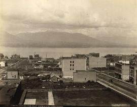
Photograph shows a view looking northwest over False Creek

Photograph shows a view looking north over False Creek including the Westminster Avenue Bridge
![[Vancouver from Mount Pleasant]](/uploads/r/null/2/3/23e8640b2925830ea0753e97d4919c0e7e1e7fa630d8293896a6f5ffbf243cbb/faf31b60-1ab8-4eaf-bca7-34193b1b7d99-A20087_142.jpg)
[Vancouver from Mount Pleasant]
Photograph shows a view looking northeast over False Creek and wooden sidewalks

Salmon Traps Off Point Roberts

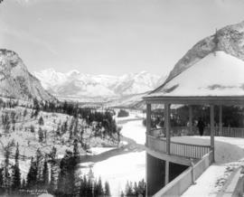
Banff Springs Hotel from Mount Rundle
Photograph shows a view towards Siwash Rock
![[View of Mount Stephen and C.P.R. Mount Stephen House]](/uploads/r/null/1/e/1e6e8a53db1cee7837e5d17590e5691988cfee52e2ec9fe085339b825762f528/2254aa43-2830-40e6-8e75-2af41d4a2347-A20117_142.jpg)
[View of Mount Stephen and C.P.R. Mount Stephen House]

Illecillewaet Valley from Look Out on Mount Abbott
Photograph shows two snow sheds and a railroad bridge

![[View looking west from the 2100 block Arbutus Street]](/uploads/r/null/f/2/f2921f36729f7e7f64637dcd8a590b2c547e48b5c27666336a0940a66b05944c/687b56f4-2b1d-4517-9192-77c3c9990680-A37758_142.jpg)
[View looking west from the 2100 block Arbutus Street]
Image shows the roof of 2128 Arbutus Street and house at 2134 Arbutus Street.
![[View looking west from the 2100 block Arbutus Street]](/uploads/r/null/8/5/851ca770f427546d3ba4168d0fcc88a31eaf280ccb7c80c81e5cf30f17d55001/b600baa0-0deb-4746-a56e-6cd54646f95d-A37759_142.jpg)
[View looking west from the 2100 block Arbutus Street]
Image shows Clarova Court (2142 Arbutus Street), Arbutus Grocery (2200 Arbutus Street [revised address 2096 West 6th Avenue]), house at 2084 6th Avenue West and St.Augustines Church
![[View looking south from the 2100 block Arbutus Street]](/uploads/r/null/b/0/b0e9b80fdc456d3654fe13d068556ce99c8299a1976a8f559a0678741e06a7a6/620e4de4-8dfe-4c98-9480-ab1f288ec69c-A37760_142.jpg)
[View looking south from the 2100 block Arbutus Street]
Photograph shows an apartment building (2137-2145 Arbutus Street) and houses (2102 and 2116 West 6th Avenue) and the Jones Tent and Awning building in the distance.
![[View of houses and an apartment in the 2100 block 6th Ave West]](/uploads/r/null/f/d/fd16159f16f68de6002a4914d631ff75868f8d5a66e1e71a6f36844ecd89ea40/811691fd-655c-4f14-a3a2-0f3e7c84835f-A37761_142.jpg)
[View of houses and an apartment in the 2100 block 6th Ave West]
Image shows houses at 2116 and 2117 West 6th Avenue.


![[View looking north showing houses and an apartment building in the 2100 block 5th Ave West]](/uploads/r/null/d/e/de8c0e3097234b24035546ee61525654b2458cdc1a63d6990a76aea2dbaf9235/0dd12395-8d1c-4cd6-acf1-063beebfa4fc-A37765_142.jpg)
[View looking north showing houses and an apartment building in the 2100 block 5th Ave West]

[Image shows the back of 2104 West 5th Avenue and the West End in the distance]

Image shows Marca Court Apartments (2085 West 5th Avenue), 2079 West 5th Avenue, 2102 Arbutus Street and 2104 Arbutus Street with a view of the Burrard Street Bridge, the West End and Downtown in the distance.
![[View looking east showing the back of houses in the 2000 block 5th Ave W]](/uploads/r/null/3/d/3d641e57c0fe73884a8468a26d686daf741c27803078b9bc4d3111cd5b7255a3/0d4ee4eb-711b-4feb-adfb-24f70b377ac0-A37768_142.jpg)
[View looking east showing the back of houses in the 2000 block 5th Ave W]
Image shows house at 2104 Arbutus Street and the roof of 2128 Arbutus Street. An election sign for Dr. Parkinson, New Democrat, Burrard is hanging on a fence.

![[Aerial view of Vancouver]](/uploads/r/null/9/b/9b3acec26123edc53f11bf2f41f3286d09254ffea9918cd31b6715395ebe18d0/26473909-fe49-4474-8c3f-05eb1e8ab059-CVA1376-252_142.jpg)
Oblique view showing Fairview, Vancouver General Hospital, False Creek and the Expo 86 and other sites under development on the north side, Granville Island, Granville Bridge, Burrard Bridge, Yaletown, Downtown, the West End, Stanley Park and the Lions Gate Bridge, North Vancouver and The Lions in the background
![[R.C.A.F. Maritime Air Command plane No. 102 flying over English Bay]](/uploads/r/null/1/3/13b6c7a118ed10801cfbe633df28806771f06f62a484edbf5de83c5acd20e0a4/ff8af309-b1af-4c30-9216-ba8a2859660d-A71302_142.jpg)
[R.C.A.F. Maritime Air Command plane No. 102 flying over English Bay]
Oblique view showing the Vancouver Maritime Museum and Kits Point residences in the foreground, and the West End, Downtown, Stanley Park and Burrard Inlet in the background.

Photograph shows houses on Comox Street.

Photograph shows a view looking south from Stanley Park including Shell and Standard marine fuel stations on the inlet and the Marine Building and the Hotel Vancouver in the background
Looking Across the Inlet from Hotel Vancouver
Photograph shows a view looking north from Georgia Street showing the west side of the 600 Block Howe Street including Manor House and beyond to Deadman's Island
Looking Across the Inlet from Hotel Vancouver
Photograph shows a view looking north across Burrard Inlet from Granville Street and Georgia Street including the Van Horne Block and the Hudson Bay Company Store
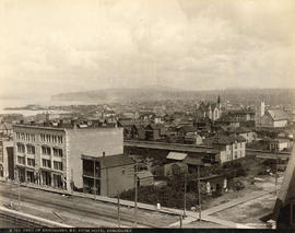
Part of Vancouver, B.C. from Hotel Vancouver
Photograph shows the east side of the 600 Block of Granville Street including the New York Block and a liquor store and beyond to the Homer Street Methodist Church, the tower of Holy Rosary Cathedral and houses

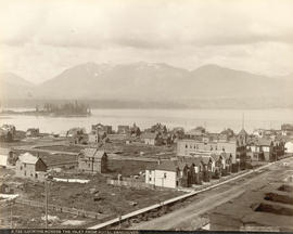
Victoria, B.C. from Government Buildings
Vancouver, B.C. from the South
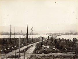
Photograph shows a view looking north from the corner of Westminster Avenue (Main Street) and 7th Avenue including the Westminster Avenue Trestle Bridge and False Creek in the background
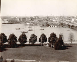
Victoria, B.C. from Government Buildings
Photograph shows the Sir James Douglas obelisk

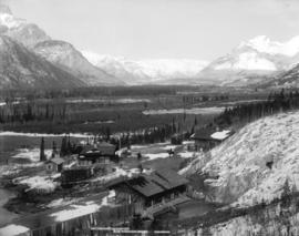
Moodyville Milling Company's Mills, Moodyville, B.C.

Banff National Park from Cave Hot Springs

Mount Sir Donald, C.P.R. Selkirks, Height 10,645 feet

Bow River Valley From Hot Springs, Banff National Park

The Narrows from Stanley Park Road, Vancouver, B.C.

![[View from the Lions Gate (First Narrows) Bridge]](/uploads/r/null/c/b/cbfaf365b669500be57ca711731ac45b780e5cbdbc42a9e9b96bd2c5e7eb1725/e0e6f596-20e0-42db-858b-600990a57ef5-A71422_142.jpg)
[View from the Lions Gate (First Narrows) Bridge]
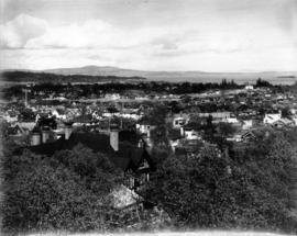
Photograph shows a view of a residential section of Victoria
![[View of Vancouver from Stanley Park]](/uploads/r/null/5/2/52315ca8f9a2fbedb2dbf9d94b4312e028d91a8469b11105d8b164dcccf85bfc/9373455d-83c7-48d1-a95c-8a0054668699-A71774_142.jpg)
[View of Vancouver from Stanley Park]
Photograph shows the Marine Building and the Hotel Vancouver in the background
![[View of Kitsilano pool] from 2330 Cornwall [Avenue]](/uploads/r/null/7/6/76608ed98f533d56b1153af09c365dc9a5c7a4258ec97635422d804b2b6f2424/e9da7371-14fc-4f2c-98f0-ceb095ca6070-A71782_142.jpg)
[View of Kitsilano pool] from 2330 Cornwall [Avenue]
![[View looking south showing the Dominion Building and the dome of the old Court House]](/uploads/r/null/c/b/cb6c4813e59a3d8087b16305354747eb9b89aeed489864528dded61eed6b337b/48734afb-985d-446c-b8a0-da53d0dd4e08-CVA1376-736_142.jpg)
[View looking south showing the Dominion Building and the dome of the old Court House]
![[View looking across the water towards Siwash Rock]](/uploads/r/null/6/1/613c1385f3a5e8688fea1d22cf59ae8e37337c93055e8d651a41647934230d24/8edbf55b-e737-45c9-b299-47db9e32407f-CVA1376-737_142.jpg)
[View looking across the water towards Siwash Rock]

Photograph shows members of the Vancouver Natural History Society