![[The exterior of St. Paul's Hospital]](/uploads/r/null/a/1/a1d09c7829f51986b9489b2283570e36c32e8f97ed6d23d1c0a166d72a13b695/ea7601bd-ec0b-4b43-ac52-59dfcb5ba8ea-A25233_142.jpg)
[The exterior of St. Paul's Hospital]
- AM54-S4-: Bu P701
- Item
- 1940
Part of Major Matthews collection
Photograph shows the southwest corner of Burrard Street and Comox Street
[The exterior of St. Paul's Hospital]
Part of Major Matthews collection
Photograph shows the southwest corner of Burrard Street and Comox Street
![[View of West Georgia Street, looking east from Westcoast Building - 1333 West Georgia Street]](/uploads/r/null/2/f/2f051029a06f3da804e0ee4562608ff99e4d008b93d9361ba340d330287ad41d/fcbc17ae-9098-4521-a93d-60b9a3383ce8-A25259_142.jpg)
[View of West Georgia Street, looking east from Westcoast Building - 1333 West Georgia Street]
Part of Major Matthews collection
Photograph shows the Elbow Room Cafe/ Restaurant on Jervis Street
![[Westcoast Building under construction - 1333 West Georgia Street]](/uploads/r/null/5/6/56fd496d60489b36f86ca4aac027a303b2866a1ff038709cfde551904a4690cd/f27df9f2-da39-4702-ba6a-eee91cfdddf4-A25260_142.jpg)
[Westcoast Building under construction - 1333 West Georgia Street]
Part of Major Matthews collection
Photograph shows construction site, West Georgia Street in a westward direction, and Coal Harbour area
![[Aerial view of the Westcoast Building construction site - 1333 West Georgia Street]](/uploads/r/null/1/c/1c5d95b307eee5602334b62cdcaaa9e2eda7f003c6ab9a85b820c19afedf5020/dee85954-684c-49db-87c1-5e4418e03233-A25262_142.jpg)
[Aerial view of the Westcoast Building construction site - 1333 West Georgia Street]
Part of Major Matthews collection
Photograph shows the 1300-1400 blocks of West Georgia Street, Pender Street and the shipyards in Coal Harbour
![Hudson's Bay Co. Store Vancouver B.C. [N.E. corner of Georgia and Granville Streets]](/uploads/r/null/b/1/b1dc3ff2c1e7fea4060c80fc3a9d642370b659d2fb344de60191e3ec55a57ef8/7a20cae9-a022-49fb-9072-4f823348188e-A24604_142.jpg)
Hudson's Bay Co. Store Vancouver B.C. [N.E. corner of Georgia and Granville Streets]
Part of Major Matthews collection

Erection of Court House flagpole
Part of Major Matthews collection
Photograph shows the intersection of Georgia and Hornby Streets, shops in the 900 block Georgia, houses in the 600 block Hornby, the Western Club (951 Dunsmuir) and the King Edward VII monument.

Erection of Court House flagpole
Part of Major Matthews collection
Photograph shows the intersection of Georgia and Hornby Streets, the King Edward VII monument, Westley Methodist Church, Y.M.C.A. building under construction, shops in the 900 block Georgia, Christ Church Cathedral, Glencoe Lodge, and the lion's on the Courthouse steps.
![[View looking north along Commercial Drive at 2nd Avenue from an apartment on the southwest corner]](/uploads/r/null/6/b/6b970775d461a8528f4f5bd794174b003c73b21e98b4d45b0804908288f04506/d59930ec-3be2-438d-aa0c-451d6aed8d43-A50028_142.jpg)
[View looking north along Commercial Drive at 2nd Avenue from an apartment on the southwest corner]
Photograph shows the east side of the 1700 Block of Commercial Drive including the Grandview Theatre and other buildings and a No. 4 streetcar
![[View looking north along Commercial Drive at 2nd Avenue from an apartment on the southwest corner]](/uploads/r/null/e/6/e6848494e0e2bf0ea4105fbcee9cdf12af2baa734b69728c891dedba56ab45c0/28e396f5-649a-49c2-a1c6-29a33eb1fad3-A50029_142.jpg)
[View looking north along Commercial Drive at 2nd Avenue from an apartment on the southwest corner]
Photograph shows the east side of the 1700 Block of Commercial Drive including the Grandview Theatre and other buildings

Part of City of Vancouver fonds
![Historical Area - 443A [1 of 2]](/uploads/r/null/a/d/b/adb0501965fd81e60dbe21d2588f6e4284600055d7da6abf19e056deee002c4f/a9fa9394-c4fe-434a-809b-207f4479fa58-CVA1095-08891_142.jpg)
Historical Area - 443A [1 of 2]
Part of City of Vancouver fonds
![Historical Area - 443 [Intersection]](/uploads/r/null/8/4/1/841a6ccb61fdb89b8aeec0037649cbd2b29f6f7011b4122a76aa858c1e93279d/743c7c53-8842-4cd5-b900-46b41849bb4d-CVA1095-08925_142.jpg)
Historical Area - 443 [Intersection]
Part of City of Vancouver fonds
Miscellaneous Historical Area - 439
Part of City of Vancouver fonds
Visible is a sign for 22 West Pender Street.
![[West 13th Avenue and Spruce Avenue intersection]](/uploads/r/null/8/8/a/88ae11c41de429c1baddd060cec00115208eecc9f90990d579e57e1e62b79258/ac78c751-ed15-4834-b82e-71a35509a36e-CVA1095-12850_142.jpg)
[West 13th Avenue and Spruce Avenue intersection]
Part of City of Vancouver fonds
![[Cement truck and buildings]](/uploads/r/null/b/0/2/b0276df1352734ab21424f4d2a3dc49856f2f9ef352b9271d842f816bb3e7ab1/9c7ddf9c-7408-4140-bb1b-656ffda9322f-CVA1095-14390_142.jpg)
Part of City of Vancouver fonds
![[Cars on downtown street]](/uploads/r/null/3/7/0/370161e5c83baa350fb19962992c2cef314e83e1c8892e90f21fc1a516302003/6132a451-7e8c-4d90-b4a0-3e38d9d28a0a-CVA1095-15067_142.jpg)
Part of City of Vancouver fonds
![Race Track - [Hastings] Park](/uploads/r/null/a/e/ae3866984dbd71adb11e4f16a3faeff5c926d7d6dbc7c68bef37bbe9e34f2147/8e72031a-2c43-4d2f-ade2-eaf99cf53105-A44678_142.jpg)
Part of Stuart Thomson fonds
Oblique view showing a view looking southeast along Renfrew Street towards Hastings Street, parts of Wall Street, Trinity Street and McGill Street, the northern section of Hastings Park, the roller coaster, the Manufacturing/Industrial Building and the Exhibition Building on the Exhibition Grounds. The photograph also shows a house at 2950 Trinity Street.

Part of Stuart Thomson fonds
Oblique view looking east along Broadway showing Kitsilano, the B.C.E.R. Lulu Island line, and the Kitsilano Trestle and Granville Bridges, Granville Island, Fairview, Downtown and Yaletown in the background

Looking East Along Georgia Street
Part of Stuart Thomson fonds
Oblique view showing Pacific Coast Lumber, boat builders at the foot of Bidwell Street, the West End east of Denman Street and the second Hotel Vancouver and Downtown in the background

Part of William Eadington Graham fonds
![[Granville Street]](/uploads/r/null/c/4/c4e0586daa905bd45de9e5a1f30bb12116a91e0809f2d21314f6f88b5d7d1f55/9183797a-b817-4a48-b7bf-1876b6d6075c-A70081_142.jpg)
Part of William Eadington Graham fonds
Part of William Eadington Graham fonds

Part of William Eadington Graham fonds
Warehouses.

Intersection of Water Street and Cordova Street
Part of William Eadington Graham fonds

Hotel Europe, 43 Powell Street
Part of William Eadington Graham fonds
![Hastings Street [00 block]](/uploads/r/null/7/8/78eeee5ffd1656608ca5c5d8e0316c16d6729e5071f2cdaae2dd224d9eb34f4c/4b394c4c-143d-48cd-aafc-1bad91736c71-A70084_142.jpg)
Part of William Eadington Graham fonds
Item is a photograph showing Pay-less Shoes, Save On Meats, the Palace Hotel and the Army & Navy Department Store.
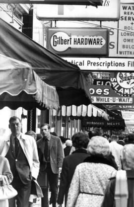
![[Shoppers in Gastown] Pandora's Box](/uploads/r/null/f/2/f2aaf07ba8add55e787b5cde876cc371762091ad78b5230968ea951b4328a575/17df0aac-8b26-4ed3-a688-a7ead4e9e632-A70139_142.jpg)
[Shoppers in Gastown] Pandora's Box
Part of William Eadington Graham fonds

Part of William Eadington Graham fonds

Part of William Eadington Graham fonds
![[View of the 800 block Granville Street]](/uploads/r/null/f/4/f4df437c429351941080a8b44105300804cec9b87face699553faa3a34d7c148/b1968748-cd10-4593-a35c-8aee8f47e451-A11709_142.jpg)
[View of the 800 block Granville Street]
![[Pedestrians crossing Hastings Street at Granville]](/uploads/r/null/c/1/c196321f306b5504e33a11140bc742bc6550cb676599309e6f0ef0723c02b896/b92f5300-6c1f-4617-b2c8-6a8c91ab799e-A12180_142.jpg)
[Pedestrians crossing Hastings Street at Granville]
![[Apartment buildings along Oak or Cambie at W. 24th Avenue with road work being completed in front]](/uploads/r/null/d/e/de34ed2d4db3a20d2b61eb501076785fa8d01d0939b8686b2588beee31a43308/b26e6c1e-97a9-4695-bbe0-f127b1f45636-A12307_142.jpg)
[Apartment buildings along Oak or Cambie at W. 24th Avenue with road work being completed in front]
![[View of Seymour Street looking north with an Orpheum movie banner hanging across the street]](/uploads/r/null/f/6/f63535cd23fbe5e804cbc0cc09ec058030f5b15e49a59f45c3b55022883c6c7c/bc682da3-1d4b-487f-83fd-7fc459c9a48f-A12580_142.jpg)
[View of Seymour Street looking north with an Orpheum movie banner hanging across the street]
![[View of Seymour Street looking south with an Orpheum movie banner hanging across the street]](/uploads/r/null/6/2/625eef7528e9d506a40d6d12d611ae6be132ebe8610a718a6bcf8c9c6e99396f/d47f456d-0a03-4d91-baa8-d4be3cdb1514-A12581_142.jpg)
[View of Seymour Street looking south with an Orpheum movie banner hanging across the street]

Photograph shows the Commodore Cabaret and Capitol Theatre.

![[Police officer, pedestrians, and traffic on Cambie Street near 12th Avenue]](/uploads/r/null/c/d/cdd1aade114ad7a3db2a6c536b43eeac4b2ba0a1739a0bbb23ad52daecc132e7/0d62707e-c9c3-46f4-a399-c5b318f73176-A13130_142.jpg)
[Police officer, pedestrians, and traffic on Cambie Street near 12th Avenue]

![[Young school traffic control attendant stopping cars to allow school children to cross the street]](/uploads/r/null/4/3/43eadd7fc05fd4203d6ba0ed8240aa776f2a1e0c0e00f755b1d9f7d29eaad210/01df74d9-ef19-413f-90df-15cc53883912-A13134_142.jpg)
[Young school traffic control attendant stopping cars to allow school children to cross the street]


![[View of Hastings Street]](/uploads/r/null/e/1/e12a09fb7ff7ab19ee2baaa74e1a60636fa231739e67344f451e3b884bf87f2f/aa647754-b527-4136-acda-8b7a23a30864-A13747_142.jpg)
![[View of the 600 block West Hastings]](/uploads/r/null/9/7/9794e66aa3ed705d8e31ec2ade4b14ca796155c9205fc6a66301c5c6611f8478/15a56ed3-121e-4b13-a226-92b98aa27e1f-A13748_142.jpg)
[View of the 600 block West Hastings]
![[View of B.C. Electric street cars on Dunbar Street from 41st Avenue]](/uploads/r/null/5/0/50622d7f19e2908c3d3649108d0ffd1242ff80c6b91cb14a538fd2a8816adbd2/2e45884d-ff0e-45d6-a2d6-15c1a0e161a2-A26804_142.jpg)
[View of B.C. Electric street cars on Dunbar Street from 41st Avenue]
Photograph shows the Safeway store and other retail businesses in the 5600 block Dunbar Street.
Part of Vancouver Express fonds

Part of Vancouver Express fonds
Photograph shows a view of Georgia Street and Robson Street looking east from Jervis Street
![[View of Georgia Street showing the B.C. Gallery of Arts]](/uploads/r/null/3/0/3057d6639bf42934bf1d7597c1fcb5e898f94648d4599b7009a09565449cfd2b/6a5541a0-f06c-445e-807e-c5f437bb68c9-A70697_142.jpg)
[View of Georgia Street showing the B.C. Gallery of Arts]
Part of Nicholas Russell fonds
![[View of Granville Street looking north from Smithe Street]](/uploads/r/null/2/9/296ac52a45a062e074035c36a5fe7d43bf512e2938e729f3fc2e364e178d4a3a/7cdfa249-5c36-431c-aac9-404adc9e0602-A37856_142.jpg)
[View of Granville Street looking north from Smithe Street]
Photograph shows retail businesses in the 800 block Granville Street between Smithe and Robson (Canada Shoe Repairing, Maple Leaf Theatre, Palms Hotel, Stewart & Co. Tailors and Bogardus-Wickins Ltd.), streetcar 284 "Fraser Ave", and the Vancouver Block clock.
![[View of Georgia Street looking east from the intersection of Burrard and Georgia Street]](/uploads/r/null/8/c/8cb732d381f3aeea1cdfd99a7d310341406c711f95934aeb3ab3fc1b1290c1ce/0d02026e-0a2c-4ae8-88a0-2d7c546053df-A37880_142.jpg)
[View of Georgia Street looking east from the intersection of Burrard and Georgia Street]
Photograph shows a view of Georgia Street with the old and new Hotel Vancouver on the south side and Christ Church Cathedral and the Medical Dental Building on the north side during the Royal Visit.
![[View of the old Hotel Vancouver from Georgia Street looking south east]](/uploads/r/null/a/b/ab8e3094528ff201ab9ab5dd1bbc4e4a9d9add39384a0b1502bc3249f988eab3/b218ff42-90cc-400a-b289-0c5fee623de8-A37881_142.jpg)
[View of the old Hotel Vancouver from Georgia Street looking south east]
Photograph shows the old Hotel Vancouver on the south side of Georgia Street at Howe during the Royal Visit.