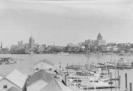
Vancouver Harbour from Rowing Club, Stanley Park
- AM1545-S3-: CVA 586-11639
- Item
- 1948
462 results with digital objects Show results with digital objects
Vancouver Harbour from Rowing Club, Stanley Park

Howe Sound : H.M.S.S. Discovery

Scenes : Vancouver Harbour and skyline etc.

Scenes : Vancouver Harbour and skyline etc.
![Fishing boats at Prince Rupert [docks]](/uploads/r/null/5/7/57cad72795de5981d5a1b74a4b6e885953b245c18485282f0028b8559053341c/2d2e9b4d-9594-40be-8441-6632a03ff306-A07220_142.jpg)
Fishing boats at Prince Rupert [docks]
Thor and Mikof boats indentified in photograph.
![Aerial view of Ocean Falls [harbour]](/uploads/r/null/6/e/6e7b1da31432ab7db7e41f602ae5cddbf3b3c4889b489f4e532690980709637e/113f4428-192c-4424-ae49-4229a54c94ba-A03282_142.jpg)
Aerial view of Ocean Falls [harbour]
![Aerial view of Ocean Falls [harbour]](/uploads/r/null/e/f/ef9a92bc0b6b8ba55e0b9d1a94be993db8ecfc0ff976199d7aaae8bc71918c63/c6f33d55-039d-41bd-b48a-33f984667eed-A06861_142.jpg)
Aerial view of Ocean Falls [harbour]
![[View of] Victoria Harbour](/uploads/r/null/6/6/66255e20916ef61cdcddf8833e5435b5075fb8b4f1e38bb884404510b2681df9/75af0c66-cf6f-4376-aba9-e67a74aa198f-A06938_142.jpg)
Inscription on verso of print "Inner Harbour and Parliament Bldg. Victoria, B.C.
![[View of] Ocean Falls [from harbour]](/uploads/r/null/a/c/ac01a62213024629cc4ad1b26c89a5bc072b7b6495192754174509e3aa713da0/d414e587-97bb-4d8e-99e2-b8f5ef2471f8-A07225_142.jpg)
[View of] Ocean Falls [from harbour]
Privy Council (Canada) collection
Item is an extract of a report of a Committee of the Privy Council, dated 8 July 1893, regarding foreshore rights in Vancouver of the Canadian Pacific Railway Company, with two accompanying maps. One map is in the file; the other one is catalogued as Map 648.
![[View across Coal Harbour towrds Downtown]](/uploads/r/null/d/d/ddf2d63627f742e05eab0ed197b3b40bc910fd24a176af8b9a75db9e2dd8133c/db7f74b3-f519-43e2-af80-62d88342cfea-A74506_142.jpg)
[View across Coal Harbour towrds Downtown]
Part of James Crookall fonds
Photograph shows the Marine Building and the Hotel vancouver in the background
![[East half Granville Island before filling]](/uploads/r/null/7/7/779c84832492846bbaaf82b09675d06ff7c3ab6303167b3827dc162b403089ef/daa3991d-6801-47d2-a003-486fb768fb00-A31771_142.jpg)
[East half Granville Island before filling]
Part of Major Matthews collection

East half Granville Island before filling
Part of Major Matthews collection
File shows harbour, log boom and industrial shoreline.

East half Granville Island before filling
Part of Major Matthews collection
![Filling of government dock at Victoria, B.C. [Victoria outer dock]](/uploads/r/null/a/c/ac3dfcbfd7931077bc2fd044d9ac56f115bc15a0a358e22caf0d0dd50edde8b7/dcf75c65-ad8b-4b52-b57c-bf2b8a6aefd3-A31777_142.jpg)
Filling of government dock at Victoria, B.C. [Victoria outer dock]
Part of Major Matthews collection
![Ocean Falls [harbour dredging]](/uploads/r/null/1/e/1e7e09e17dcb3d0b28a30119bceaa2f16244f3ff09e4db0d582bf8f4d720d60c/64cfdccc-461e-4627-b615-908f9ba91921-A31758_142.jpg)
Ocean Falls [harbour dredging]
Part of Major Matthews collection
Vancouver, British Columbia. Souvenir from the lion gateway
Part of City of Vancouver Archives technical and cartographic drawing collection
Item is a promotional brochure for the City of Vancouver, included as a holiday supplement in the Vancouver Daily and Weekly World newspapers. The brochure was designed to be folded.

Vancouver Harbour, British Columbia, 1932
Part of City of Vancouver Archives technical and cartographic drawing collection
Item is a nautical chart showing English Bay and Burrard Inlet with soundings in feet, anchorages, locations of submarine cables, and ferry lines. Land features include city blocks and district lot numbers. Includes inset maps of the North Arm of Burrard Inlet and Vancouver Island.
Part of City of Vancouver Archives technical and cartographic drawing collection
Item is a brochure promoting tourism along the British Columbia coast using Union Steamships routes. The unfolded brochure has text and illustrations on one side and on the other text with a map showing the routes to destinations described in the brochure.
Vancouver Harbour : plan of south shore, Burrard Inlet between Heatley Ave. and Victoria Dr.
Part of City of Vancouver Archives technical and cartographic drawing collection
Item is a map which shows parcels of land along Burrard Inlet and district lots in downtown Vancouver. Piers, factories and mills along the waterfront are identified. Soundings are shown in feet.
National Harbours Board
Part of Harold D. Kalman fonds
Item is a drawing of a harbour that may be Coal Harbour.
![Vancouver harbour from the roof garden [of David] Spencer's [Department] Store](/uploads/r/null/d/b/db5a883c9aac8bed679b57c2205d549efa86b2a28446fb64721146f1befa6a70/d5e169c6-2878-4aa0-ae91-fea056b71eac-CVA258-8_142.jpg)
Vancouver harbour from the roof garden [of David] Spencer's [Department] Store
Part of Hubert William Lovell fonds
Pier D, Empress of Russia, Deadman's Island and Brockton Point are visible in the distance. Photograph was taken in the summer.

Part of Hubert William Lovell fonds
Photograph was taken in the summer.
![[View of Avalon Harbor at Santa Catalina Island]](/uploads/r/null/f/d/fdf3a14b471b917b980dbdcf659078213b34df352708beb19482ea5610608647/a3fc8135-be2c-49fe-878d-0d214a9bc4d0-CVA1477-515_142.jpg)
[View of Avalon Harbor at Santa Catalina Island]
Part of L.D. Taylor family fonds
![[View of rock formation in Avalon Harbor at Santa Catalina Island]](/uploads/r/null/e/3/e3aaf19c0247951aa4bcd8b9a1f129120747587064bc56811243d6e16aa5088f/d01725e0-69c7-4546-8bd6-dcc25d9d802b-CVA1477-516_142.jpg)
[View of rock formation in Avalon Harbor at Santa Catalina Island]
Part of L.D. Taylor family fonds
!["Empress of Asia" at C.P.R. Pier B-C [with "Melanope" alongside]](/uploads/r/null/0/f/0fb16442c7c62c275d85acaa7682f0d3fa8286edc35254c9405675c22e5550ad/b0542e8a-245e-4cf5-a9ab-330cf0dd2d68-A08348_142.jpg)
"Empress of Asia" at C.P.R. Pier B-C [with "Melanope" alongside]
Part of Major Matthews collection
J.S. Matthews' notes with print or negative in Archives.
![[Aerial view looking east over Stanley Park, Coal Harbour and Burrard Inlet]](/uploads/r/null/d/0/d02fee694c486ac2accdeefb505d0dae5fcb42789ef16de49322d845e3c04b44/be8c34ce-7c09-4c0e-a395-f083c9134080-A43248_142.jpg)
[Aerial view looking east over Stanley Park, Coal Harbour and Burrard Inlet]
Part of Major Matthews collection
Oblique view

Part of Major Matthews collection
Photograph shows Lions Gate Bridge, Beaver Lake, Lost Lagoon, Prospect Point, Brockton Point, Deadman's Island, Royal Vancouver Yacht Club, H.M.C.S. Discovery, Brockton Oval and English Bay.

![BC [British Columbia] postcard - The Rockies to the Pacific](/uploads/r/null/1/2/1226936/e2a6b4cf-7e7e-48c3-8e3b-6a150d917129-MI-342_142.jpg)
BC [British Columbia] postcard - The Rockies to the Pacific
Part of Yaletown Productions Inc. fonds
Film is a promotional video for the province of British Columbia. Focusing on different sections of the province in turn the video highlights the features and tourist attractions of each. According to the donor this is most likely the original of the final production with sound and image. Director Mike [Michael] Collier; cinematography Norm Keziere, Dave Geddes, Bob Asgeirsson, Bill Rounds, Tommy Tompkins, and John Anderson; editor Rober Brandreth-Gibbs; research Sharon McGowan; narration script Don White and Sharon McGowan, narrator Art Hives; video services Post Haste Video; film lab Alpha Cine Services; sound mix Pinewood Studios; special thanks to Tourism British Columbia. Produced by Yaletown Productions. b&w 00:10:57-00:11:04 and 00:18:47-00:19:22.
![BC [British Columbia] postcard - The Rockies to the Pacific [Japanese version]](/uploads/r/null/1/2/1226943/1fe338ae-0558-47de-bc78-ac3a556700b9-MI-343_142.jpg)
BC [British Columbia] postcard - The Rockies to the Pacific [Japanese version]
Part of Yaletown Productions Inc. fonds
Film is a promotional video for the province of British Columbia this version has Japanese narration. Focusing on different sections of the province in turn the video highlights the features and tourist attractions of each. According to the donor this is most likely the original of the final production with sound and image. Director Mike [Michael] Collier; cinematography Norm Keziere, Dave Geddes, Bob Asgeirsson, Bill Rounds, Tommy Tompkins, and John Anderson; editor Rober Brandreth-Gibbs; research Sharon McGowan; narration script Don White and Sharon McGowan, narrator Art Hives; video services Post Haste Video; film lab Alpha Cine Services; sound mix Pinewood Studios; special thanks to Tourism British Columbia. Produced by Yaletown Productions. Ends with an advertisement for 'Canada's Best Selling Video Postcard Series.' b&w 00:10:57-00:11:04 and 00:18:47-00:19:22.

Part of Major Matthews collection
Photograph shows water, tugs, log booms and an industrial section of shoreline.

West half Granville Island before filling
Part of Major Matthews collection
![[Aerial view of Vancouver Harbour looking east from Lost Lagoon]](/uploads/r/null/a/7/a7c598133f7f2c78a6bb65602262bc193ceb787389db5cd31ded3868025265ca/72eb674f-7c20-4ecc-a618-3a1e88e660c8-A62798_142.jpg)
[Aerial view of Vancouver Harbour looking east from Lost Lagoon]
Part of Major Matthews collection
Oblique view showing Coal Harbour, Deadman's Island, Denman Arena, the Marine and other buildings, and the piers along the waterfront
![[South side of Coal Harbour at low tide with four-man scull]](/uploads/r/null/5/d/5d701a946729d7f820e43fd05966163d0f63a80eebee16e404fb12ca24cb73f7/1d70962a-414f-40fe-8b16-3cfc609c2393-A20515_142.jpg)
[South side of Coal Harbour at low tide with four-man scull]
Part of James Luke Quiney fonds
![N.P.A.A.O. [North Pacific Association of Amateur Oarsmen. One-man scull at] Esquimalt](/uploads/r/null/2/c/7/2c7a041f4573b48dfe710ad66ac640d7e95a4566083535aa2ed127c5268a1b18/931a73ba-3eb4-4564-9a85-04a72e883331-CVA7-318_142.jpg)
N.P.A.A.O. [North Pacific Association of Amateur Oarsmen. One-man scull at] Esquimalt
Part of James Luke Quiney fonds
![[View of Vancouver Harbour and waterfront looking north]](/uploads/r/null/8/a/8ac88e032f61ec518dc9db5cf599c0aba57a3464e9ef196b0e9d7f900c5a4592/31479d67-42ce-4888-afbf-eb5e079d5850-A60955_142.jpg)
[View of Vancouver Harbour and waterfront looking north]
Part of John William Freeston fonds
Panoramic view showing Burrard Inlet, the Immigration Building, The "Edmore" at C.P.R. Pier A, C.P.R. Pier D, Pier B-C construction site and the Vancouver Riowing Club, Deadmans Island, Coal Harbour, Brockton Point and the Lions in the background
![[Sailors rowing to shore from the H.M.S. "Amphion" in Vancouver harbour]](/uploads/r/null/9/b/9bfc3c89bfb227c2ed0b8630533f99722a1277d24cb1e70d34c7740bb5438220/9d00534a-5cfe-42bf-819c-c9fceb9dbf60-A07602_142.jpg)
[Sailors rowing to shore from the H.M.S. "Amphion" in Vancouver harbour]
Part of Major Matthews collection
J.S. Matthews' notes with print or negative in Archives.
![[Two boys watching boat enter Bull Harbour]](/uploads/r/null/e/f/ef96d3d9dfb3dcfe7f79214898e35aa876eda5260f5360b9b123ca3620bf651f/62f4ecf2-2cd4-4176-9222-7d45f15e67b5-A09300_142.jpg)
[Two boys watching boat enter Bull Harbour]
Part of Major Matthews collection
Photograph shows Peter and David McCallum, sons of Mr. and Mrs. Bruce McCallum at the radio weather station near Shushartic, B.C.
![[Ships in Vancouver Harbour]](/uploads/r/null/d/6/d629566f7cb9f7a78af71c85ba3ea4a2cf7167728b91400cee1d65fd777443b3/fbfab785-d4fa-4637-8632-cf9d4b4bddca-A08055_142.jpg)
Part of Major Matthews collection
J.S. Matthews' notes with print or negative in Archives.

Pleasure craft "Nancy Anne" in Vancouver harbour
Part of Stuart Thomson fonds
Part of Stuart Thomson fonds

![Vancouver Rowing Club [4 man crew on Coal Harbour, arena in background]](/uploads/r/null/9/3/935840dc4b6c8c35b8b892893f6258a14f1cf901a02acf4940f39acfa1849aaa/04258287-c4b5-454c-b01b-694fac748a20-A00426_142.jpg)
Vancouver Rowing Club [4 man crew on Coal Harbour, arena in background]
Part of Stuart Thomson fonds
![Vancouver Rowing Club [8 man crew on Coal Harbour with Stanley Park causeway in background]](/uploads/r/null/0/b/0b7cbc84696c537aae2ba9f958eb8f0d59b6af742fd832bb028e3e708458a461/e95d446c-68ec-444d-ae9a-95215c3787db-A00424_142.jpg)
Vancouver Rowing Club [8 man crew on Coal Harbour with Stanley Park causeway in background]
Part of Stuart Thomson fonds

Vancouver Rowing Club Eight at V.R.C. spring regatta
Part of Stuart Thomson fonds
Photograph shows
![Vancouver Rowing Club regatta [in Coal Harbour]](/uploads/r/null/a/e/aea8be199ec45ccdd094f8522d641eeb65f1727a99257a6fd819f5fc1a238747/07b65312-a17f-4a09-a8ad-6f5d06c86828-A00750_142.jpg)
Vancouver Rowing Club regatta [in Coal Harbour]
Part of Stuart Thomson fonds

Vancouver Rowing Club, Coal Harbour
Part of Stuart Thomson fonds

Vancouver Rowing Club, Coal Harbour
Part of Stuart Thomson fonds

W.E. Boeing's yacht M.V. "Taconite" [bow view leaving harbour
Part of Stuart Thomson fonds
Yacht is featured leaving Burrard Inlet harbour.