
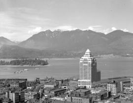
British Columbia - Vancouver skyline : Westcoast bldg. and scenery from inside
- AM1435-: CVA 1435-71
- Item
- [197-?]
Item is photograph showing Coal Harbour, Stanley Park, and Burrard Inlet.
462 results with digital objects Show results with digital objects
British Columbia - Vancouver skyline : Westcoast bldg. and scenery from inside
Item is photograph showing Coal Harbour, Stanley Park, and Burrard Inlet.

British Columbia - Vancouver skyline : Westcoast building and scenery from inside
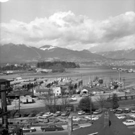
Item is photograph showing downtown Vancouver looking north west towards Stanley Park and Coal Harbour

Part of Major Matthews collection

Part of City of Vancouver Archives technical and cartographic drawing collection
Item is a sheet with three nautical charts. The main chart depicts Burrard Inlet from Atkinson Point [Point Atkinson] in the west to the "townsite of Port Moody" in the east. The inset charts depict Vancouver Harbour and the Second Narrows.
![Burrard Viaduct Construction [1 of 10]](/uploads/r/null/2/7/2788a9638050d7cbfc021e29977d956f423fe6048bb7c29c035ea57bda6dd66c/5df17b4f-3ebf-4f8d-ac21-de11bd89033f-A66652_142.jpg)
Burrard Viaduct Construction [1 of 10]
Part of City of Vancouver fonds
Building of Burrard Viaduct with Coal Harbour in the background, including part of Deadman's Island and a floating fuel station on the left and the mountains beyond.
![Burrard Viaduct Construction [2 of 10]](/uploads/r/null/5/7/57426101abc66a2ab407c951565e28bb07f8f27238a35bb05d7478ded4e540b1/8b87415b-c4bc-4c5c-bf5c-89e3546722c2-A66653_142.jpg)
Burrard Viaduct Construction [2 of 10]
Part of City of Vancouver fonds
Building of Burrard Viaduct with Coal Harbour in the background, including part of Deadman's Island and a floating fuel station on the left and the mountains beyond.
By-laws and general information
By-laws and general information
By-laws of the National Harbours Board (Vancouver Harbour)
Canada's Pacific gateways : realizing the vision.

Canadian National Railways steamship "Prince Robert" leaving harbour
Part of Stuart Thomson fonds

Canadian National Railways steamship "Prince Robert" leaving harbour
Part of Stuart Thomson fonds
Cates : a tradition that was born with Vancouver
Item includes a history of C.H. Cates & Sons Ltd., fleet capacity and sketch of a proposed facility.
C.H. Bailey's Table of distances from port to port.

City and Deadman's Island near Nine 0'Clock Gun
Part of Major Matthews collection

City from Stanley Park, and first gasoline service station. Imperial Oil Limited.
Part of Major Matthews collection
Photograph shows the Immigration Building, the Marine Building and Deadman's Island
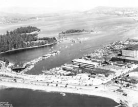
Item is photograph showing an aerial view of Stanley Park and Coal Harbour.

Item is photograph showing an aerial view downtown Vancouver looking northwest towards Coal Harbour and Stanley Park.

Item is photograph showing an aerial view downtown Vancouver looking northwest towards Coal Harbour and Stanley Park.
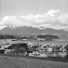
Item is photograph showing an aerial view downtown Vancouver looking northwest towards Coal Harbour and Stanley Park.

Coal Harbor Vancouver. Height of Water In Upper End 9 ft. above. Zero
Part of Major Matthews collection
Panoramic view showing Lost Lagoon, the Stanley Park Causeway under construction and the Vancouver Rowing Club.
![[Coal Harbour]](/uploads/r/null/8/3/83bd003a993aaa90a0c6aea33d3521bf9163833f067d66579783658045125695/447583bd-7a62-4edd-9558-f0bcaf009c90-A16626_142.jpg)
Part of City of Vancouver fonds
![[Coal Harbour?]](/uploads/r/null/f/b/fb269570031b2a3828f329c97b9db78a5236f47cf4286fb78bf3c2058c53b0de/626b353c-ab4a-4c40-bcaf-41aaec70fe04-A16630_142.jpg)
Part of City of Vancouver fonds
Photograph shows waterfront with bridge, railway tracks and houses.
![[Coal Harbour?]](/uploads/r/null/b/4/b488b986b859b20d49e5b4d6f59cb320223b0da4668774c67790e46f15e737a7/ea0b239a-5c45-449d-80f0-04a4483b3cd5-A16627_142.jpg)
Part of City of Vancouver fonds
Photograph shows marsh and water with gazebo in background.
![[Coal Harbour?]](/uploads/r/null/1/c/1c43ca1c74017572cccbbeb20b07dae64a1d3dc2d6ed6573e3555df279535121/dee93f4d-4cde-4f0b-b504-dfb863bfa77d-A16629_142.jpg)
Part of City of Vancouver fonds
Photograph shows water, bridge, and houses.
![[Coal Harbour]](/uploads/r/null/e/6/e641a81bbc0d7d8adfb51e6e32ecb57659f5dccdce517fb88dd14160144e3e52/c67b13d2-e877-4fb3-8b2f-0de875c9280a-A16625_142.jpg)
Part of City of Vancouver fonds

![[Coal Harbour?]](/uploads/r/null/d/b/db2de6c93437b31527635deddfa2d1b0228f1dfd0d78c0bf6d754fd685fc663b/dccf9129-e23d-46e6-8e3f-0adde1d833b8-A16628_142.jpg)
Part of City of Vancouver fonds
Photograph shows marsh and water with gazebo in background.
![[Coal Harbour?]](/uploads/r/null/1/0/10b1e3b62444e17b20e5c87b9cb37773568bcad1eb9f6ef2efd8c228b7f06408/5aa04f62-7a7b-4a73-a8bf-7920b9573446-A16631_142.jpg)
Part of City of Vancouver fonds
Photograph shows marsh, water and bridge.
![[Coal Harbour]](/uploads/r/null/7/7/77cafdf979fc613841ced240338b064a0d12d9e69c44cdbc458b83707b742e85/c32a0c26-2ba0-446c-bdac-ea9cff6ffa7a-A71815_142.jpg)
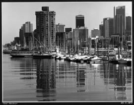
![[Coal Harbour and Downtown from the Causeway]](/uploads/r/null/d/f/5/df5783e376ce091eaa747d85bdac39ab081c295ffb29db71e675d1326a870c77/8b685d69-96da-4273-b4c4-226e0f99cfc5-CVA260-1224_142.jpg)
[Coal Harbour and Downtown from the Causeway]
Part of James Crookall fonds
![[Coal Harbour and downtown Vancouver]](/uploads/r/null/9/6/963211ebd8afe965840840d585cec1a2b8ebc9fa5ccad89c0d8ff6fa5b09b325/aae76ee7-a000-4d73-be7e-1831535a08b6-CVA1435-630_142.jpg)
[Coal Harbour and downtown Vancouver]
Item is photograph showing Coal Harbour and downtown Vancouver, taken from the Stanley Park causeway.
![[Coal Harbour and downtown Vancouver]](/uploads/r/null/9/2/924cd84f7afa829f5183160b8a807996bf9c4e5c5aa58f8a386bfce3eb7e665a/d60e2151-8687-4709-b421-fc93e2bcfce5-CVA1435-632_142.jpg)
[Coal Harbour and downtown Vancouver]
Item is photograph showing Coal Harbour and downtown Vancouver, taken from the Stanley Park causeway.

Part of Major Matthews collection
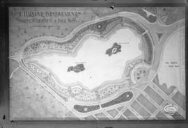
Coal Harbour Improvements Suggested Treatment of Inner Basin
Part of City of Vancouver fonds
Photograph shows map of suggested improvements.
![Coal Harbour [showing] Deadman's Island and Stanley Park](/uploads/r/null/d/6/d6ce3aeb165a91b522ef077ca8156f7e3a8ab8b628022e341045a857c0742bbc/b376f1e6-bd3a-4ad5-92c6-958dc0d2db65-A09656_142.jpg)
Coal Harbour [showing] Deadman's Island and Stanley Park
Part of Major Matthews collection
Part of Major Matthews collection
Oblique view looking northeast showing the Denman Arena, the Georgia Street entrance to Stanley Park, the Vancouver Rowing Club, Brockton Point and Deadmans Island
![[Coal Harbour view from Denman Street]](/uploads/r/null/f/4/f4ee6b5b8d147b8a774a97a7b59f6f8c29bb8792a52da1695f47dce307742555/f90773a4-4b21-478d-bd42-505e1d441b47-A16624_142.jpg)
[Coal Harbour view from Denman Street]
Part of City of Vancouver fonds
![[Coal Harbour, showing part of Stanley Park, Deadman's Island, and houseboats]](/uploads/r/null/1/2/12067ca2ea5ea0ff39ee45868194a05deff43c7c02b79dc9558e8710362bcd57/cc755324-9751-4940-ac1f-281c8e8867e0-A02323_142.jpg)
[Coal Harbour, showing part of Stanley Park, Deadman's Island, and houseboats]
Part of City of Vancouver Archives technical and cartographic drawing collection
Item is a map showing dredging of Coal Harbour, with depth soundings given in feet (taken from Admiralty charts). The map hows which areas of land in Coal Harbour were dry at low water levels.
Canada. Department of Public Works
![[Coastal steamship] "Prince George" aground at 1st Narrows](/uploads/r/null/7/2/72c3f456be5f97334f1438b1e5d24a33f35c2e770793ebc9cd9f0f85ef9c3e41/323ecce2-b557-45f4-84eb-2d110852168f-A16207_142.jpg)
[Coastal steamship] "Prince George" aground at 1st Narrows
Part of Stuart Thomson fonds
![[Construction of Granville Square]](/uploads/r/null/a/f/a/afa392337c82fdd483821e71e84c783387f62fc34d3e76aa496c753d6b9d3459/7e4197b6-5cc9-41da-bff3-053313fb4718-CVA1385-24_142.jpg)
[Construction of Granville Square]
Part of O.B. Allan Ltd. fonds
Item shows construction at Granville Square (200 Granville St.) as well as harbour with "Hong Kong Mail" and other ship in dock. Caption reads "Project 200 presents: your window on world commerce. Construction now at plaza level and the start of 30 floors. March 1971".
Part of City of Vancouver fonds
This item is a print of one of seven images created by graphic designer and artist David Hornblow for the City of Vancouver street banner series known as "Waterfront Images". This print depicts a portion of a shipping container and container cranes.
Hornblow, David

C.P. steamer "Princess Mary" passes Brockton Point, leaving harbour
Part of Stuart Thomson fonds
![[C.P.R. Royal Mail ship "Empress of Japan" leaving Vancouver Harbour]](/uploads/r/null/c/0/c05cfe11a2709216a9ae3f057fcb5e8bbad06d44125b6c4e82d066b52864d525/0289afa5-94fe-457e-bc67-09ad52578e50-A08768_142.jpg)
[C.P.R. Royal Mail ship "Empress of Japan" leaving Vancouver Harbour]
Part of Major Matthews collection
J.S. Matthews' notes with print or negative in Archives.
![[CPR steamships at dock and under sail]](/uploads/r/null/e/6/e6220a75a37e187c4130f03475ed21e9839e7f638daf714d1d0b3ec7491856bf/f14187fa-8e7f-4b23-933c-8c8697388a39-A49459_142.jpg)
[CPR steamships at dock and under sail]
Part of H.A. Price collection
Photograph shows one CPR steamship moored at the east side of Pier "D" while another steams out of Vancouver Harbour.

Item is a photograph of a high angle view looking northeast over the C.P.R. train tracks at Vancouver Harbour.