Showing 148 results
Archival description106 results with digital objects Show results with digital objects
Heritage inventory 1986 : evaluation forms
Heritage inventory 1986 : evaluation forms
Design concept for proposed National Avenue pedestrian bridge connection (Main St.)
Design concept for proposed National Avenue pedestrian bridge connection (Main St.)
Heritage evaluation forms : deletions from register (buildings demolished for redevelopment)
Heritage evaluation forms : deletions from register (buildings demolished for redevelopment)
Downtown and West End buildings inventory photographs
Downtown and West End buildings inventory photographs
Wards, ward boundaries information binder
Wards, ward boundaries information binder
Yaletown information binder
Yaletown information binder
Gastown (area 32) reconstruction photographs
Gastown (area 32) reconstruction photographs
Bus volumes projected
Bus volumes projected
Overall Planning Division data project printouts
Overall Planning Division data project printouts
Downtown and West End building facades inventory photographs
Downtown and West End building facades inventory photographs
Strata title conversion files
Strata title conversion files
Peak hour bus volumes
Peak hour bus volumes
Built heritage research records
Built heritage research records
City of Vancouver urban renewal : scheme 3
City of Vancouver urban renewal : scheme 3
Aerial survey [photograph] #17
Aerial survey [photograph] #17
Redevelopment in downtown Vancouver report no. 5
Redevelopment in downtown Vancouver report no. 5
Planning Department film collection
Planning Department film collection
Heritage inventory photographs
Heritage inventory photographs
Planning Department miscellaneous records
Planning Department miscellaneous records

Map of downtown Vancouver
Urban renewal - redevelopment projects no. 1 & 2 maps
Urban renewal - redevelopment projects no. 1 & 2 maps
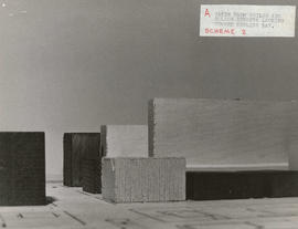
Taken from Chilco and Nelson streets looking towards English Bay

Taken from Comox and Nicola streets looking towards English Bay

Taken from Pendrell and Broughton streets looking towards English Bay
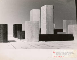
Taken from Chilco and Nelson streets looking towards English Bay

Taken from Comox and Bidwell streets looking towards English Bay

Taken from Comox and Bidwell streets looking towards English Bay
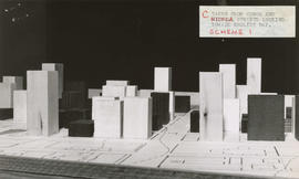
Taken from Comox and Nicola streets looking towards English Bay

Taken from Pendrell and Broughton streets looking towards English Bay
Aerial survey cronaflex positives and paper prints
Aerial survey cronaflex positives and paper prints
Urban renewal - project no. 1 maps
Urban renewal - project no. 1 maps
Heritage planning subject files
Heritage planning subject files
Planning Department's slide file photographs
Planning Department's slide file photographs
Existing service stations, retail shopping centres and commercial zoning
Existing service stations, retail shopping centres and commercial zoning
Summary of preliminary report on the downtown transportation study
Summary of preliminary report on the downtown transportation study
City of Vancouver : generalized future land use in relation to feasibility network
City of Vancouver : generalized future land use in relation to feasibility network

Rezoning application map (Point Grey Road)
Planning Director's Lower Mainland Regional Planning Board files
Planning Director's Lower Mainland Regional Planning Board files
Planning operational records
Planning operational records
Aerial survey photographs
Aerial survey photographs
Zoning and Development By-law amendment records
Zoning and Development By-law amendment records
City-owned property planning records
City-owned property planning records
Heritage Planner's photographs
Heritage Planner's photographs
Subdivision files
Subdivision files
Planning Department reference library
Planning Department reference library
Planning Department maps, plans and drawings
Planning Department maps, plans and drawings
Planning Department photographs
Planning Department photographs
Demolished and redeveloped heritage properties files
Demolished and redeveloped heritage properties files
Results 101 to 148 of 148
- « Previous
- 1
- 2
- 3