Showing 1440 results

Archival description
City of Vancouver Archives technical and cartographic drawing collection With digital objects
Print preview View:

City of Vancouver

Item is a copy of sections of a November 1889 fire insurance map that have been pieced together. Includes the area between Seymour and Dunlevy Streets, from the south shore of the Burrard Inlet to Keefer Street. Map shows Chinatown, part of False Creek, and buildings and their uses (commercial, residential, industrial). The name of the business, business owner, or type of business is noted for most commercial and industrial buildings.

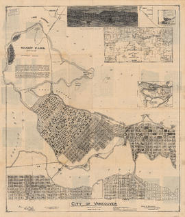
City of Vancouver : Canadian Pacific town site

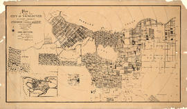
Part contains four maps. The main map shows district lots and block numbers in Vancouver from Vine Street in the west to Boundary Avenue (Glen Drive) in the east and Stanley Park in the north to 9th Avenue (Broadway) in the south. Three smaller maps include an index plan to district lots in Vancouver, South Vancouver, New Westminster, and Burnaby; a world map showing Canadian Pacific mail steamship lines; and an index plan of Vancouver city limits.

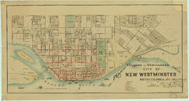
Map of the municipalities of New Westminster, British Columbia

Part consists of the map component of a pamphlet. The map shows the location of churches, school, canaries, sawmills, backyards, tanneries, woolen mills, hatcheries, roads, and railways on a map which depicts the area of Greater Vancouver from the Gulf of Georgia east to Harrison Lake and south to the United States border.

Map of part of the New Westminster District shewing the proposed new municipality of Burnaby

Item is a map showing boundaries of a proposed new municipality of Burnaby, which would include all land outside the "old" City of Vancouver between Burrard Inlet and the Fraser River and west of North Road. The map also shows the boundaries of District Lots in this area.

Garden, Hermon and Burwell, Provincial Land Surveyors

Stuart's pocket map of Vancouver, B.C.

Item is an illustrated map of the "old" City of Vancouver. The map shows streets, transportation, and significant businesses (such as C.P.R. wharves, smelter, Hastings Mill, Morse's Mill, C.P.R. Shops, City Hospital, sawmill, slaughter houses, and smallpox hospital). The map includes "Index of Streets, Government Offices, Churches, [etc.], including "Civic and other Principal Buildings", "Places of Amusement or Recreation", "Public Schools", "Principal Mills, Foundries and Manufactories", "Principle Bankers", Principal Hotels", and "Miscellaneous".

The map was designed to be folded into a cover, which is included.

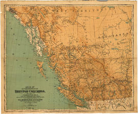
Map of the Province of British Columbia

Item is a a map of the province of British Columbia as well as parts of Alberta and the Northwest Territories. The map depicts the route of the Canadian Pacific Railway, including all the stations between Calgary and Vancouver. Also shown are the railways between Nanaimo and Victoria on Vancouver Island and between Edmonton and Calgary in Alberta

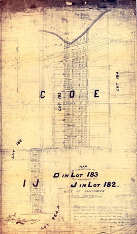
Plan of subdivision of D in lot 183 and subdivision of J in lot 182, City of Vancouver

Item is a subdivision map showing block and lot numbers of subdivisions D and J in lots 183 and 182 respectively. These areas are situated roughly between Burrard Inlet in the north and First Avenue in the south and between Victoria Drive in the east and Clark in the west.

Garden, Hermon and Burwell, Provincial Land Surveyors

[Map of Pioneer Place showing the area deeded to the City of Vancouver by the C.P.R.]

Item is a hand drawn map of Pioneer Place (also known as Pigeon Park), on the corner of Hastings and Carrall Streets. Map is colour coded to indicate the portion deeded to the City by the C.P.R., the portion being asked from the C.P.R. for street purposes, and the portion leased by the C.P.R. to Mr. Horne. Included on the map are Horne Block, Garden Block, a sidewalk, lanes, and a fountain. An engineer's estimates of improvements are noted on the right side of the map. Notes at the top of the map by J.S. Matthews, City Archivist read "Presented in 1934 by Ex-Alderman W.H. Gallagher. The date is about 1895."

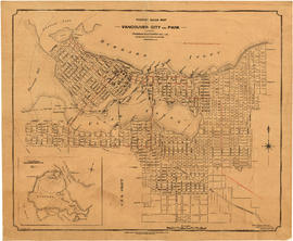
Tourist guide map of Vancouver City and park

Item is a map shows city streets for downtown, Fairview and Mount Pleasant, and major civic, municipal and industrial buildings, as well as "electric street railways shown in red." An inset map shows the roads and trails of Stanley Park. The map is annotated with green pencil shading "signifies where houses are" and blue shading indicates areas where it "is almost entirely vacant land - small trees."

Panoramic view of the City of Vancouver, British Columbia, 1898

Item is a map showing an oblique aerial eye view of Vancouver, including Burrard Inlet, Upper False Creek Flats and False Creek. Streets, buildings and businesses are identified. Inset shows location of the Vancouver City foundry, Machine Works and Sugar Refinery. The map includes pictorial representations of buildings, industrial activity around Burrard Inlet, watercraft and vegetation. The perspective view of the map is to the south/south-east.

The map was originally included as a supplement to the Daily World newspaper.

British Columbia. Port Moody

Item is a map showing subdivisions of townships in Coquitlam, Port Moody, Pitt Meadows, Surrey, Langley, Sumas, Sardis and Chilliwack. The west coast of British Columbia from Burrard Inlet to the Sechelt peninsula is shown as well as Vancouver Island and the surrounding Gulf Islands. Trails, post offices and railway stations are included.

Results 101 to 150 of 1440