
Section 23 : Maple Street to English Bay to Balaclava Street to Third Avenue

Section 25: Jericho Beach to English Bay to Blanca Street to Fourth Avenue
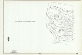
Section 26 : Blanca Street to English Bay to University Endowment Lands to Fourth Avenue

Section 31 : Main Street to Fourth Avenue to Oak Street to Sixteenth Avenue
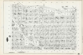
Section 32 : Clark Drive to Great Northern Way to Main Street to Sixteenth Avenue

Section 34: Rupert Street to Fifth Avenue to Nanaimo Street to Grandview Highway
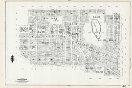
Section 40 : Naniamo Street to Thirteenth Avenue to Inverness Street to Twenty-fourth Avenue
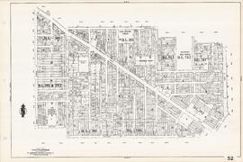
Section 52 : Nanaimo Street to Twenty-second Avenue to Inverness Street to Thirty-second Avenue

Section 60 : Quebec Street to Thirty-seventh Avenue to Oak Street to Forty-sixth Avenue

Section 65 : Carnarvon Street to Thirty-third Avenue to Camosun Street to Forty-first Avenue

Section 73 : Inverness Street to Forty-seventh Avenue to Quebec Street to Fifty-seventh Avenue

Section 76 : Boundary Road to Forty-ninth Avenue to Kerr Street to Asquith Avenue

Section 78 : Boundary Road to SE Marine Drive to Kerr Street to Fraser River

Section 82 : Crompton Street to SE Marine Drive to Main Street to Fraser River

Section 86 : Laurel Street to Sixty-seventh Avenue to Angus Drive to Fraser River

Section 88 : Angus Drive to Fifty-seventh Avenue to Macdonald Street to Fraser River

Continuacion de los reconocimientos hechos en la cost No. America

Chart of the N.W. coast of America and the N.E. coast of Asia
Sheet 1 : Broughton Street to Coal Harbour to Stanley Park to English Bay
Sheet 3 : CP Rail yards to Drake Street to Burrard Street to False Creek

Sheet 6 : Carrall Street to Burrard Inlet to Burrard Street to Dunsmuir Streert
Sheet 10 : Woodland Drive to Burrard Inlet to Heatley Avenue to Grant Street
Sheet 16 : Prince Edward Street to False Creek to Bridge Street to 18th Avenue
Sheet 17 : Manitoba Street to False Creek to Birch Street to 16th Avenue

Sheet 21 : Trafalgar Street to 11th Avenue to Alma Road to 16th Avenue
![Sheet 27 P.G. : [West Boulevard] to 50th Avenue to Carrington Street to Fraser River](/uploads/r/null/0/9/0/090f76634cdc314f819f2efd30a3577fb99766beb5ce44d02150f9e6c580758f/e5df76bd-fc07-4e76-a264-fba49009ca66-LEG1831_142.jpg)
Sheet 27 P.G. : [West Boulevard] to 50th Avenue to Carrington Street to Fraser River
Sheet 28 P.G. : Shaughnessy Heights and Granville Street to Bodwell Road to Wesst Boulevard to Magee Road
Sheet 31 P.G. : Dixon Road to Peters Road to Cypress Street to Fraser River

Sheet 34 S.V. : Knight Street to Twenty-fifth Avenue to Ontario Street to Fourtieth Avenue
![Sheet 36 S.V. : [Chambers Street] to Government Road to Knight Street to Forty-third Avenue](/uploads/r/null/c/8/7/c8717cec4116ee8e006673b056d7755ec1fbee4b2f57fcbf47598267a83a4b9d/82fe22d0-c322-4a08-a843-a90655c1e2a1-LEG1831_142.jpg)
Sheet 36 S.V. : [Chambers Street] to Government Road to Knight Street to Forty-third Avenue
Sheet 38 S.V. : Victoria Drive to Fifty-ninth Avenue to Fraser Street to Fraser River

Sheet 39 S.V. Boundary Road to 56th Avenue to Victoria Road to Fraser River
![Sheet 42 S.V. : Boundary Road to Government Road to [Duchess Street] to School Road](/uploads/r/null/1/9/f/19f97eb9c0c1f54c0626e037784329d1b53b8d06b7e1735915b0b85ecec96a4c/15d29110-32de-4fa6-8396-8b134a40e766-LEG1831_142.jpg)
Sheet 42 S.V. : Boundary Road to Government Road to [Duchess Street] to School Road
Sheet 44 H.T. : Boundary Road to Pender Street to Nanaimo Street to Ninth Avenue
![Sheet 50 [Burnaby] : [Antrim Road?] to Jubilee Road to Boundary Road to [Marine Way]](/uploads/r/null/b/c/f/bcfcdc3e5a34b9cb2d151f7ca97982970014d2254913bae08f91f1afdc151ae0/ac9cd205-6ea8-4e27-bd30-7143e2004b1d-LEG1831_142.jpg)
Sheet 50 [Burnaby] : [Antrim Road?] to Jubilee Road to Boundary Road to [Marine Way]
![Sheet 62 [NW] : Brunette River to Tenth Avenue to Eighth Street to Fraser River](/uploads/r/null/8/c/0/8c00b096f6257381d8b28e6fe276a91bec30a8f112a0ac0c770cb6fc7550fb89/8a082b06-1a35-4b7d-a7d3-53c33798cd56-LEG1831_142.jpg)
Sheet 62 [NW] : Brunette River to Tenth Avenue to Eighth Street to Fraser River

Sheet 4 N.V. William Street to Twenty-eighth Street to Chesterfield Avenue to Seventeenth Street
![Sheet 9 N.V. : Seymour River to Lynn Canyon to Hoskins Road to [Keith Road?]](/uploads/r/null/3/7/5/375911fd91c57f28aaa91e483da08e145effcd26c69d693ebf72f1bf590e9442/c9afad59-d672-4c8e-96b7-0bdd968fb8fc-LEG1831_142.jpg)
Sheet 9 N.V. : Seymour River to Lynn Canyon to Hoskins Road to [Keith Road?]

Sheet 11 N.V. : Lower Seymour Creek

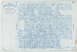
Distribution system of waterworks, City of New Westminster, British Columbia
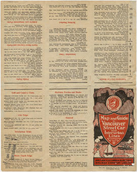
Map and guide to Vancouver street car and interurban lines

Vancouver city and suburban lines
![Hastings Townsite [Boundary Road to 5th Avenue to Kamloops Street (?) to 33rd Avenue]](/uploads/r/null/7/f/0/7f0fe2a27b9af4f20ad7837792af3bbb3aa93c3487024e69b14fa38144134f19/8e7a0e66-c6cc-40ca-bbac-4ea73db77437-LEG1800_142.jpg)
Hastings Townsite [Boundary Road to 5th Avenue to Kamloops Street (?) to 33rd Avenue]

Map and guide to Vancouver street car and interurban lines

Reference schedule AA - Floodplan map

Map of Lulu Island and Sea Island ; Municipality of Surrey ; Map of Maillardville ; University Endowment Lands

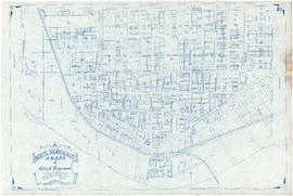
Map of downtown section of Vancouver ; Diagram of New Westminster, B.C., downtown section

Automobile road map of Greater Vancouver and environs : map cover

Through the Canadian Pacific Rockies : a large scale map of the mountains from Calgary to Sicamous : map cover

Through the Canadian Pacific Rockies : a large scale map of the mountains from Calgary to Sicamous : inside map cover