![View on the Chuckanut Drive, Pacific Hiway [Highway]](/uploads/r/null/8/a/1/8a1138124e805230ee4e02a2286badfe44ff977e5a46f86409a07f8161f7aa71/cd291a91-4ce1-4e1f-8aeb-db5917ba39b1-CVA289-003_142.jpg)
View on the Chuckanut Drive, Pacific Hiway [Highway]
- AM427-S4-F3-: CVA 289-003.264
- Item
- [ca. 1925]
Part of William Orson Banfield fonds
View on the Chuckanut Drive, Pacific Hiway [Highway]
Part of William Orson Banfield fonds

In Mount Rainier Park : On the ferry at Goble, crossing the Columbia
Part of William Orson Banfield fonds

In Mount Rainier Park : The house at the entrance to Rainier Park
Part of William Orson Banfield fonds
![In Mount Rainier Park : Putting the snow down Myrtle [Kilpatrick]'s neck and -](/uploads/r/null/1/e/b/1eb46d63861dfd7fcae6f366256f537172234921d86359c301479124c4bc3232/f76406b0-9d1e-4189-936b-87651920e1f4-CVA289-002_142.jpg)
In Mount Rainier Park : Putting the snow down Myrtle [Kilpatrick]'s neck and -
Part of William Orson Banfield fonds

In Mount Rainier Park : Tatouche Range, motors just arriving
Part of William Orson Banfield fonds

Part of William Orson Banfield fonds

Part of William Orson Banfield fonds
A timber flume near Hood River
Part of William Orson Banfield fonds
![M[oun]t Hood from Cloud Cap Inn](/uploads/r/null/2/6/9/269c54a2cff178fca9ab040b6ac521a828671e22d056a8f7c504cc188f657369/373abcd8-cd58-4da3-9943-5745f7130f6e-CVA289-004_142.jpg)
M[oun]t Hood from Cloud Cap Inn
Part of William Orson Banfield fonds
Part of William Orson Banfield fonds

Part of William Orson Banfield fonds

Part of William Orson Banfield fonds
Item is a photograph showing Beatrice Timmins feeding a bear at a roadside.
![Table M[oun]t[ain]](/uploads/r/null/9/3/f/93f45b7e77f91c47f5825d46db7a4f7a92ca8db083def523a6c7b348e94d30c5/1125e985-3495-40fc-81b4-81f89ec4fe25-CVA289-004_142.jpg)
Part of William Orson Banfield fonds

Part of William Orson Banfield fonds
![Lower face [of Grand Coulee Dam]](/uploads/r/null/9/c/a/9ca4a3394db580ec0a046099dc5cc5aab4af92a1d5c570a0882f4bfe501f49d8/e8ca452f-e656-4672-9e0e-15c5c05bd9eb-CVA289-005_142.jpg)
Lower face [of Grand Coulee Dam]
Part of William Orson Banfield fonds
![Distant view [of Grand Coulee Dam]](/uploads/r/null/c/9/6/c96305b71bf4f3b9fb1a0e8554c8ce50b1ab4a92e03dd91faab096f6aa29982b/f72c131d-cf00-4f0b-984d-33783d353b9e-CVA289-005_142.jpg)
Distant view [of Grand Coulee Dam]
Part of William Orson Banfield fonds

Part of City of Vancouver Archives technical and cartographic drawing collection
Item is a map showing the Pacific Coast of British Columbia and Washington and Oregon states as surveyed by French explorer Jean-Francois de Galaup (Laperouse) in 1786, and the routes of his ships Astrolabe and Boussole. The map shows the Pacific coastline from Cap Rond (Tillamook Head) in Oregon at latitude 45 degrees and 40 minutes in the south to Baeie de Clonard (Beresford Bay, northwestern tip of Haida Gwaii) in British Columbia at latitude 54 degrees and 10 minutes in the north. Other major place names on the map include Nootka, Pointe Boisee, Baie St. Louis, Iles de Sartine, Mont Fleurieu, Cap Fleurieu, Cap Hector, Mont de la Touche, Baie de la Touche, and Baie de Clonard. Vancouver Island is shown as part of the mainland. Map includes latitudes and longtitudes as well as indication of elevations. Map is a plate from the "Atlas de Voyage de la Perouse".
Part of City of Vancouver Archives technical and cartographic drawing collection
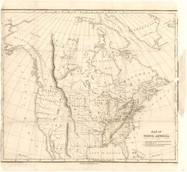
Item is a map showing "Mr. Stuart's route through the United States, and Canada in 1828, 29 & 30" and "the boundary of the United States, both on the side of the British Possessions, & those in Mexico." The northern border of United States territory west of the Rocky Mountains is incorrectly noted at 54/40, to reflect American claims of the time.
![1 Deer Longmire [Mt. Rainier]](/uploads/r/null/e/1/e/e1e7d6400146bab4f0d33a3cb9f820d2773cf4077aa9c9ae8554ec55c862da5b/e7f6864f-9503-4421-a797-1be455ffe931-CVA260-2077_142.jpg)
Part of James Crookall fonds
Item is a stereograph
![3 Deer Longmire [Mt. Rainier]](/uploads/r/null/e/b/5/eb595bf79f053445a135185ea1e8ef9e7894f90fabe4f6336318e58acd70d110/468e38ad-1a73-44f0-b973-8770dafb1071-CVA260-2079_142.jpg)
Part of James Crookall fonds
![Mount Rainier from Longmire [?] [Range]](/uploads/r/null/1/0/8/1088d5ac0afeb217f147026186082922f02b572ad58ea5f2a9de567e4c7c76be/02b3caf3-7359-4f5c-97b1-fc7c4fea9cf7-CVA260-2080_142.jpg)
Mount Rainier from Longmire [?] [Range]
Part of James Crookall fonds
![Mount Rainier across from [Rim] at Longmire (through trees)](/uploads/r/null/e/4/7/e47758ea80dc2818f05595a08e28fde1e9c0c4ea0c5c87418d653b07d23431aa/2a69ab14-3ea2-4956-ae56-83d5f2c82bf3-CVA260-2083_142.jpg)
Mount Rainier across from [Rim] at Longmire (through trees)
Part of James Crookall fonds

Mount Rainier from Ricksecker Point
Part of James Crookall fonds

View towards Longmire, Ricksecker Point
Part of James Crookall fonds
![2 Tatoosh Range (wildflowers) [Mt. Rainier]](/uploads/r/null/e/d/0/ed00d272a1147a16e1cd05759072d6ae2f66e6ea45c10a9cf6c1c6b48791b488/e4859104-5f36-4753-8136-804efd7a1f2d-CVA260-2096_142.jpg)
2 Tatoosh Range (wildflowers) [Mt. Rainier]
Part of James Crookall fonds

Southwestern districts : Map no. 1K : comparative geographical study
Part contains information on the southwestern districts of British Columbia, including population, climate, agriculture, industry, labour, and education; itineraries for exploring the various regions; information on Canadian customs regulations and game regulations; and diagrams of road routes to British Columbia from California and Alberta/western Washington.

