
- AM1415-: CVA 1415-446
- Item
- Apr. 1961
Part of Arthur Collier fonds
Part of Arthur Collier fonds
Part of Arthur Collier fonds

Part of Arthur Collier fonds

Part of Arthur Collier fonds

Part of Arthur Collier fonds

Part of Arthur Collier fonds
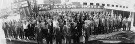
B.C. Fire Chiefs Association 28th Annual Fire College Aug. 18-21, 1959 - Astor Hotel, Burnaby, B.C.
Part of City of Vancouver fonds
Panoramic group portrait
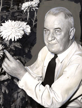
Gordon Waddell, Burnaby's first Fire Chief
Part of Pacific Press fonds

Part of Arthur Collier fonds

Part of Arthur Collier fonds

Part of Arthur Collier fonds

Part of Arthur Collier fonds

Part of Arthur Collier fonds

Part of Arthur Collier fonds

Part of Arthur Collier fonds

Part of Arthur Collier fonds
Part of Arthur Collier fonds

Part of Arthur Collier fonds

Part of Arthur Collier fonds

Part of Arthur Collier fonds
Part of Arthur Collier fonds
Part of Arthur Collier fonds

Dial map of Greater Vancouver and suburbs
Part of City of Vancouver Archives technical and cartographic drawing collection
Part contains a street map of Vancouver, Burnaby, New Westminster, West Vancouver, and North Vancouver showing railways, hospitals, parks and block numbers. The map includes two dials (numbered circles, paper indicators, a grid of block numbers and a street index used to find locations).

Dial map of Greater Vancouver and suburbs
Part of City of Vancouver Archives technical and cartographic drawing collection
Part contains a street map of Vancouver, Burnaby, New Westminster, West Vancouver and North Vancouver showing block numbers, street car, bus, and railway lines, parks and hospitals. Map includes two dials (a numbered circle, a paper indicator, a grid of block numbers and a street index used to find locations). A small inset map shows the Capitol Hill/Scenic Park area of Burnaby in greater detail.

Part of Major Matthews collection

Dominion Bridge Co., Boundary Road and Lougheed Hwy
Part of Walter E. Frost fonds
![[Pedestrians outside the A.B.C. Coffee Shop, 3700 East Hastings Street]](/uploads/r/null/e/8/e89e7f86b2113f751f3b52a1529f684a1e4e3169e89366bb2260d408df7dc358/285b0db7-fbe3-499c-bc86-f3ed786b0cd5-A13594_142.jpg)
[Pedestrians outside the A.B.C. Coffee Shop, 3700 East Hastings Street]
![[Interior view of the library at Oakalla prison]](/uploads/r/null/6/6/66182ea62b4ac548526033cf052ad91bdc4fc5a1837d2d2a7a84cbabd612b3f7/03ce81e2-d420-4753-83a5-5650481e64af-A12624_142.jpg)
[Interior view of the library at Oakalla prison]
![[Interior view of a jail cell at Oakalla prison]](/uploads/r/null/9/b/9bc2a2c0c9b0aa484750b34d906a83e3581acf2ca6cc4cf30b811d797cf17df1/4aa779a2-c2e9-4d6f-88e5-162e3e610670-A12620_142.jpg)
[Interior view of a jail cell at Oakalla prison]
![[Interior view of a jail cell at Oakalla prison]](/uploads/r/null/8/0/8015d880e11144ebc60c774a5c9a535fc6959b7a48483e481a397514c87a69f6/dea1a9c7-0b76-4407-8da5-c65421d27330-A12623_142.jpg)
[Interior view of a jail cell at Oakalla prison]
![[Meal served at Oakalla prison]](/uploads/r/null/2/7/27752c0f754fd773ae2cc6e29935cf6f346781c443b852eae0cf9413d33fdfaf/d174a04e-d9a2-496c-a89d-a4f906db6355-A12625_142.jpg)
[Meal served at Oakalla prison]
![[Oakalla prison uniform laid out on a table]](/uploads/r/null/2/5/25891445b38bcad05cbedf036916b9037ffdd80be8735bcf46befbaacb6f52c9/a9167112-3815-41d8-9a6b-aabc85f83c3f-A12622_142.jpg)
[Oakalla prison uniform laid out on a table]
![[Pedestrians outside the A.B.C. Coffee Shop, 3700 East Hastings Street]](/uploads/r/null/f/b/fb7130cd85e916df580245549c195af5fff3e032a942ba9a66ca8dd9ac12b608/6136eeee-b6f6-4c4f-ac62-84a3b43143f6-A13593_142.jpg)
[Pedestrians outside the A.B.C. Coffee Shop, 3700 East Hastings Street]
![[Pedestrians outside the A.B.C. Coffee Shop, 3700 East Hastings Street]](/uploads/r/null/a/1/a16d688f551f9f0254c19dfce03447de040e6456a9a7f51186d1cb659024aa48/a5e1e3e2-7832-4319-a050-47f13adc5b98-A13595_142.jpg)
[Pedestrians outside the A.B.C. Coffee Shop, 3700 East Hastings Street]
![[Magistrate G.A. Grant]](/uploads/r/null/1/0/103eef864e958bbe0b828f50f49d4ced2665274ada9d4aa0c5f48c81962ea914/c7daf8ab-74c3-491f-b32c-d661892cd30c-A61170_142.jpg)
Part of Major Matthews collection
![[Interior view of a jail cell at Oakalla prison]](/uploads/r/null/9/7/9739b043ee835d6c35f9bf2dd0c300fc5e9ad7ee208320cba9ff32a76fcdbdbf/6f880bce-08b6-4fd8-9322-964073ce2c1d-A12621_142.jpg)
[Interior view of a jail cell at Oakalla prison]
![Dom[inion] Bridge Co. [under construction], Boundary Road and Lougheed [Highway]](/uploads/r/null/d/2/d293f06a4e8869d37c889aec707fabf25277fd4a92db73a8744f49a808de8665/1fdbe88d-201b-4c3e-9132-6d273bd20a95-A21844_142.jpg)
Dom[inion] Bridge Co. [under construction], Boundary Road and Lougheed [Highway]
Part of Walter E. Frost fonds
![[Kelly, Douglas and Co. Ltd. warehouse under construction - Sussex Avenue and Kingsway]](/uploads/r/null/0/c/0c5b3abf025ae96cc12bafbdd78a93bbabe78056cabf3e35582c2d755ccf12f8/64ffa667-6585-4bf4-87a1-705aac19f96c-A24798_142.jpg)
[Kelly, Douglas and Co. Ltd. warehouse under construction - Sussex Avenue and Kingsway]
Part of Major Matthews collection
Construction progress photograph.
![[Kelly, Douglas and Co. Ltd. warehouse under construction - Sussex Avenue and Kingsway]](/uploads/r/null/f/e/fecbd5281e0c19238d73d23e3208b03dd201e795192bae188d7a126b009118e9/8c0dd2a8-ac4f-42f1-9af4-8882062f126b-A24796_142.jpg)
[Kelly, Douglas and Co. Ltd. warehouse under construction - Sussex Avenue and Kingsway]
Part of Major Matthews collection
Construction progress photograph.
![[Kelly, Douglas and Co. Ltd. warehouse under construction - Sussex Avenue and Kingsway]](/uploads/r/null/1/0/1085e3f2cc2d9e71c3eba7d84639326c3f4f9490cdc2f93a9319103473fc4d5e/8ab85886-0818-4539-9927-1fcd0bbedea7-A24797_142.jpg)
[Kelly, Douglas and Co. Ltd. warehouse under construction - Sussex Avenue and Kingsway]
Part of Major Matthews collection
Construction progress photograph.

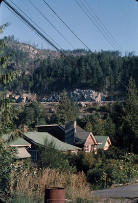
Central Mortgage and Housing, 1203 Royal Bank Bldg. : interior and exterior of new house, Burnaby
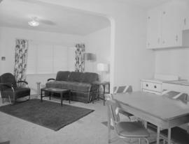
Central Mortgage and Housing, 1203 Royal Bank Bldg. : interior and exterior of new house, Burnaby

Central Mortgage and Housing, 1203 Royal Bank Bldg. : interior and exterior of new house, Burnaby

Central Mortgage and Housing, 1203 Royal Bank Bldg. : interior and exterior of new house, Burnaby

Central Mortgage and Housing, 1203 Royal Bank Bldg. : interior and exterior of new house, Burnaby

Shell Oil Company opening of new plant at Shellburn

Shell Oil Company opening of new plant at Shellburn
Photograph shows a CKWX microphone

Shell Oil Company opening of new plant at Shellburn

Shell Oil Company opening of new plant at Shellburn

Shell Oil Company opening of new plant at Shellburn