
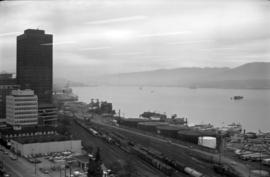
British Columbia - Vancouver skyline
- AM1435-: CVA 1435-18
- Item
- [197-?]
Item is aerial photograph showing downtown Vancouver looking north west towards Stanley Park.
British Columbia - Vancouver skyline
Item is aerial photograph showing downtown Vancouver looking north west towards Stanley Park.

British Columbia - Vancouver skyline
Item is aerial photograph showing downtown Vancouver looking north west towards Stanley Park.

British Columbia - Vancouver skyline
Item is aerial photograph of downtown Vancouver looking north west towards Stanley Park.

British Columbia - Vancouver skyline
Item is photograph of Stanley Park taken through an office window.

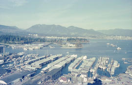
British Columbia - Vancouver skyline
Item is photograph showing Coal Harbour and Stanley Park.

British Columbia - Vancouver skyline
Item is photograph showing Stanley Park and Coal Harbour.

British Columbia - Vancouver skyline
Item is photograph showing Coal Harbour and Stanley Park.
British Columbia - Vancouver skyline
Item is photograph showing view of Coal Harbour and Stanley Park taken from Westcoast building.

British Columbia - Vancouver skyline
Item is photograph showing downtown Vancouver looking north west towards Stanley Park and Coal Harbour.

British Columbia - Vancouver skyline
Item is aerial photograph showing part of downtown Vancouver looking north west towards Stanley Park.

British Columbia - Vancouver Skyline
Item is aerial photograph showing downtown Vancouver, Stanley Park, and Burrard Inlet.
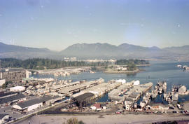
British Columbia - Vancouver skyline : view from north side of Westcoast bldg
Item is photograph showing view of Coal Harbour and Stanley Park from Westcoast Energy building.
British Columbia - Vancouver skyline : view from north side of Westcoast bldg
Item is photograph showing view of Coal Harbour and Stanley Park from Westcoast Energy building.

British Columbia - Vancouver skyline : view from north side of Westcoast bldg
Item is photograph showing view of Coal Harbour and Stanley Park from Westcoast Energy building.
British Columbia - Vancouver skyline : view from north side of Westcoast bldg
Item is photograph showing view Coal Harbour and Stanley Park from Westcoast Energy building.

British Columbia - Vancouver skyline : view from north side of Westcoast bldg
Item is photograph showing view of Coal Harbour and Stanley Park from Westcoast Energy building.
British Columbia - Vancouver skyline : view from north side of Westcoast bldg
Item is photograph showing view of Coal Harbour and Stanley Park from Westcoast Energy building.

British Columbia - Vancouver skyline : view from north side of Westcoast bldg
Item is photograph showing view of Coal Harbour and Stanley Park from Westcoast Energy building.

British Columbia - Vancouver skyline : view from north side of Westcoast bldg
Item is photograph showing view of Coal Harbour and Stanley Park from Westcoast Energy building.

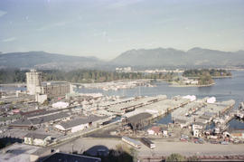
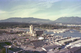
British Columbia - Vancouver skyline : view from north side of Westcoast bldg
Item is photograph showing view of Coal Harbour, Stanley Park, and Burrard Inlet from Westcoast Energy building.

British Columbia - Vancouver skyline : Westcoast bldg. and scenery from inside
Item is photograph showing Coal Harbour and Stanley Park.

British Columbia - Vancouver skyline : Westcoast bldg. and scenery from inside
Item is photograph showing Stanley Park, taken from Westcoast Energy office building.

British Columbia - Vancouver skyline : Westcoast bldg. and scenery from inside
Item is aerial photograph showing Coal Harbour and Stanley Park.
British Columbia - Vancouver skyline : Westcoast bldg. and scenery from inside
Item is photograph showing Coal Harbour and Stanley Park.

British Columbia - Vancouver skyline : Westcoast bldg. and scenery from inside
Item is photograph showing downtown Vancouver and Stanley Park.

British Columbia - Vancouver skyline : Westcoast bldg. and scenery from inside
Item is photograph showing Coal Harbour and Stanley Park from Westcoast Energy office building in downtown Vancouver.

British Columbia - Vancouver skyline : Westcoast bldg. and scenery from inside
Item is photograph showing Coal Harbour and Stanley Park.

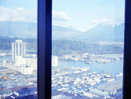
British Columbia - Vancouver skyline : Westcoast bldg. and scenery from inside
Item is photograph showing Coal Harbour, Stanley Park, and Burrard Inlet.

British Columbia - Vancouver skyline : Westcoast building and scenery from inside
Item is photograph showing downtown Vancouver looking north west towards Stanley Park and Coal Harbour

Brockton Point Lighthouse, Stanley Park, Vancouver, B.C.

Brockton Point, Stanley Park from water
Part of Samuel H. Logan fonds

Building near Stanley Park maintenance yard
Part of City of Vancouver fonds

Part of Elizabeth Walker fonds
Item is a photograph showing buildings in Jericho Park, now hostel buildings at 1515 Discovery Street.


Part of City of Vancouver Archives sound recording and moving image collection
Film shows children and adults roasting wieners over a fire and eating hotdogs outside a small house or cabin. Scenes of children playing on the beach and in the sand at Hadden Park.
Gabriel, Margaret (nee Kruger)

Part of Charles F. Smith fonds
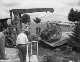
Centuries Rock being moved into place on top of time capsule, Queen Elizabeth Park
Part of Artona Studios fonds

Centuries Rock plaque, Queen Elizabeth Park
Part of Artona Studios fonds
Item is a photograph of the plaque. Written on the plaque is:
Centuries Rock
Beneath this rock is a small vault containing a sealed copper box placed there July 21st, 1954. It contains all manner of illustrated and documentary material dealing with affairs of this date. The box will be opened for inspection July 21st, 2054. Canada's first civic arboretum was established on this site in 1949. Within its boundaries are Canada's native trees, shrubs and plants and many exotic specimens. It is a community project sponsored by the pulp and paper industry of British Columbia and developed by the Board of Park Commissioners of Vancouver.

Ceremony in Queen Elizabeth Park
Part of Artona Studios fonds
Item is aphotograph showing man at microphone, crowd behind, framed painting in park.

Ceremony in Queen Elizabeth Park
Part of Artona Studios fonds
Item is a photograph showing two men near a microphone, holding a painting, with a crowd looking on.

Ceremony in Queen Elizabeth Park
Part of Artona Studios fonds
Item is a photograph showing man at microphone, flag draped onto rock.

Ceremony in Queen Elizabeth Park
Part of Artona Studios fonds
Item is a photograph showing a man at a microphone, holding a flag over a rock, with a crowd looking on.

Ceremony in Queen Elizabeth Park
Part of Artona Studios fonds
Item is a photograph showing a man at a microphone, a flag draped on a rock, with crowd looking on.

Ceremony in Queen Elizabeth Park
Part of Artona Studios fonds
Item is a photograph showing two men near a microphone, holding a painting, with a crowd looking on.

Chamaecyparis nootkatensis 'pendula' (N.I.I.) (McCleery Park, 15-6)
Part of City of Vancouver fonds
![Chambers Family - Group [portrait in Clark Park]](/uploads/r/null/0/3/0324af74bf7073516b0fca5e235edec6c5a8dbf67f93a037d6b98018e56b5063/acc1b80d-d53a-4d46-b436-f91107e7616a-A17123_142.jpg)
Chambers Family - Group [portrait in Clark Park]
Part of Stuart Thomson fonds
Individuals identified in the photograph are:
Front row (L-R): Muriel Mary Chambers, George Rhodes Chambers, Bessie Henrietta Chambers and Pearl Elva Chambers
Back row (L-R): Claude Rhodes Chambers, Rupert Rhodes Chambers and Bernard Rhodes Chambers
![Chambers Family - Group [portrait in Clark park]](/uploads/r/null/1/1/118b69452b8ab91b683435805106082dbaf890e7a2e7b6a6ebbe18623e9dccdf/d3df08b3-a337-4762-ae6d-120ea294fa71-A17124_142.jpg)
Chambers Family - Group [portrait in Clark park]
Part of Stuart Thomson fonds
Individuals identified in the photograph are:
Front row (L-R): George Rhodes Chambers, Rupert Rhodes Chambers and Bessie Henrietta Chambers
Back row (L-R): Pearl Elva Chambers, Claude Rhodes Chambers, Bernard Rhodes Chambers and Muriel Mary Chambers


Part of City of Vancouver Archives technical and cartographic drawing collection
Map is a City Engineering Department base map of Vancouver, showing city blocks and Canadian Pacific, Canadian National and Great Northern Railway lines. Parks, golf courses, hospitals, schools, theatres and other structures are identified. "Metric Vancouver" and "Guide Map 15" appear in the bottom right corner of the map.

Part of City of Vancouver Archives technical and cartographic drawing collection
Map is a City Engineering Department base map of Vancouver, showing city blocks and Canadian Pacific, Canadian National and Great Northern Railway lines. Parks, golf courses, hospitals, schools, theatres and other structures are identified. "Guide Map 15" appears in the bottom right corner of the map.