
"A Safe Passage" - The Missanabie in dock at Plymouth after disembarking the 47th Battalion
- AM1376-: CVA 172-02
- Item
- Nov. 1915
"A Safe Passage" - The Missanabie in dock at Plymouth after disembarking the 47th Battalion

A ship being built at a shipyard

Photograph shows a house built with B.C. timber

![[A trail beside the water]](/uploads/r/null/c/2/c216ff3d9822c69c7f64dbcf47aadb3acdab62e3a37b202a73cbb9cf2c404fe3/4a5c7f81-4d31-4bb8-a784-3f61cefd19f1-A71863_142.jpg)
![[A trail through the trees]](/uploads/r/null/0/e/0e53077715134415d22c7f58a7de2b72bef1c0aaac0ad9e38d67005f339a4116/a68982b5-6bba-4598-9352-dca53bfd42bd-A71840_142.jpg)
![[A trail through the trees]](/uploads/r/null/f/f/ff19a0cc8e3562e7c025c3d734e943cf875c11f53c6baefc291d0f70452e3c72/acb5d9e4-5d7d-4060-af99-a20d37411461-A71849_142.jpg)
![[A trail through the trees]](/uploads/r/null/b/2/b23417f46fbff314ffd4724efd9d82a9e14411448a472874cbb68d268edd37aa/202e8647-6493-47a2-b47c-ade5d3e00d1c-A71818_142.jpg)
![[A trail through the trees]](/uploads/r/null/9/8/98a2fbf0d0b1af72f542d99c3cf40d77d36e53a9da4df5c390658599cc090da6/e035248a-e445-4914-8fe4-896fb7f6cb1f-A71825_142.jpg)
![[A trail through the trees]](/uploads/r/null/4/f/4fb741bf23f8aa172f97ef626a04410ec536a7e649d91e1ed9d9ed879e5b7d1d/897deff4-56cc-4da8-88db-ed0e801bdf39-A71831_142.jpg)

A village, a dam, and a factory
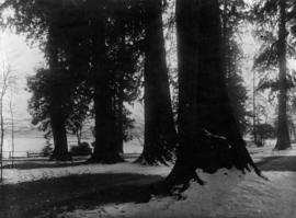
A winter evening, Stanley Park
![[A woman and girl on a road]](/uploads/r/null/4/3/43160757588168ed5b8d6a26c5ef6f7f1ea3828239dc0b928c4776178231a070/a17dc457-3628-4af4-8b18-f2796226e833-A71858_142.jpg)
![[A woman milking a cow]](/uploads/r/null/c/0/c049a68d98f6c99654396f263404c6f86e261b33382004b60f738e5bc638c1c7/d64a9cac-561e-418a-9622-11ae6dbd95c3-A20107_142.jpg)

A.B. Sayer Smith's clearing, on Chilco Street near English Bay
![[Access point to the Pacific National Exhibition grounds]](/uploads/r/null/c/0/c0a46a9289d18da938053a7b7c938b1eb43a42443f7c57be397f0f95f67656ec/6ec25da7-9269-49f4-a830-54f40aabedf7-A37921_142.jpg)
[Access point to the Pacific National Exhibition grounds]
![[Access point to the Pacific National Exhibition grounds]](/uploads/r/null/3/b/3bfdc2d8e2c1cb68c0b54dd461d96ae7631032b770c59b2de2232f8a6f0e3ec8/c6ca964a-f207-426e-a663-f94fbfee62be-A37926_142.jpg)
[Access point to the Pacific National Exhibition grounds]
![[Adjutant] and Mrs. Collier](/uploads/r/null/8/7/1/8713273f9d0aad5271a2d42726faa8f3e0cfa0a23e193d53c6f8bb2f8b275d4a/86217631-a8c2-4157-87a4-9933ae7039bf-CVA312-53_142.jpg)
![[Adjutant] and Mrs. Collier and family [on front porch]](/uploads/r/null/1/6/c/16c9bb879fa40f5a42b81329d20771ed4759840cfbf5d3e0735e4b978d395b11/a9c9ac8f-0017-46ba-a3ff-2cb71adf1bfd-CVA312-43_142.jpg)
[Adjutant] and Mrs. Collier and family [on front porch]

Photograph shows Admiral Seymour School class with Harold Marsland at the first left of the second row.

Item is a photograph showing A.E. (Albert Edward) Beck.

Aerial of Second Narrows bridge and the Alberta Pool Elevator Company
Item is a photograph related to the building of the Second Narrows Bridge.

Aerial photo, oblique, 41st Ave. and Oak St., Vancouver
Item is a photograph from Oak and 41st Ave, looking north, with a large partially cleared green area at the bottom of the frame, with downtown, Stanley Park, and the North Shore Mountains in the upper frame.

Aerial photo, oblique, CPR docks in foreground, looking south Granville Street at centre
Item is a photograph of the Vancouver waterfront, looking southwest down Burrard Street, showing the waterfront and downtown Vancouver, including Waterfront Station, Hotel Vancouver, Marine Building, Burrard Bridge, Granville Street Bridge, and the city beyond.
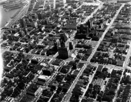
Aerial photo, oblique, downtown Vancouver
Item is a photograph of downtown Vancouver looking northeast. The photo is centred on the Hotel Vancouver and includes the provincial courthouse, surrounding areas, and part of the port of Vancouver.

Aerial photo, oblique, downtown Vancouver to North Shore Mountains
Item is a photograph of the Vancouver area looking northwest over downtown Vancouver including the Hotel Vancouver, Provincial Courts, the Marine Building, Stanley Park, Burrard Inlet, Lion's Gate Bridge, and Coal Harbour.

Aerial photo, oblique, False Creek, Vancouver
Item is a photograph of False Creek, looking northeast. The photo has (from left to right) the Burrard bridge, the Kitsilano Trestle Bridge, the (old) Granville Street Bridge, and the Cambie Bridge.

Aerial photo, oblique, Fisherman's cove with marinas, West Vancouver

Aerial photo, vertical, Deadman's Island, Coal Harbour and surrounding area
Item is a photograph of Deadman's Island, including Coal Harbour, and the southwest part of Stanley Park. Compass north is the left side of the photo.
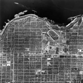
Aerial photo, vertical, Exhibition Park and surrounding area
Item is a photograph of Exhibition Park and the surrounding area, looking north. The area photographed runs from Vancouver Harbour to Charles Street, and from Lakewood Drive to Skeena Street.

Aerial photo, vertical, Exhibition Park, Vancouver

Aerial photo, vertical, False Creek, Fairview to Kits Point
Item is a photograph of False Creek, showing English Bay to W 16th Avenue, and from Maple Street to the Cambie Street Bridge. Includes the Burrard Street Bridge, the new Granville Bridge, the Cambie Bridge, and Granville Island.

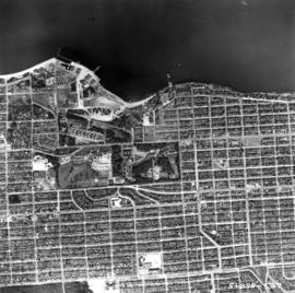
Aerial photo, vertical, Iona Island and Fraser River
Item is a photograph of Iona Island. The area photographed includes the northwest corner of Sea Island and the southwest corner of Southlands. Rafts of lumber are visible.
Aerial photo, vertical, Jericho Beach Park and Kitsilano
Item is a photograph of Jericho Beach Park and the surrounding area, looking north. The area photographed runs from English Bay and Jericho Beach to W 16th Avenue,and from Sasamat Street to Balaclava Street.

Aerial photo, vertical, Little Mountain and Oakridge and surrounding area
Item is a photograph of Little Mountain and Oakridge, showing from W 30th Avenue to W 54th Avenue, and from Hudson Street to Main Street. Includes the Langara golf course and Queen Elizabeth Park.

Aerial photo, vertical, Marpole and junction of Fraser River, Bridgeport
Item is a photograph of Marpole and northern Richmond, looking north. The area photographed centres on the fork of the Fraser River at Sea Island, and runs from W 67th Avenue to Cambie Rd., and from the western most tip of Richmond Island to the west tip of Mitchell Island. Includes the Marpole Bridge and both Oak Street and Moray bridges under construction.

Aerial photo, vertical, University of British Columbia and University Endowment Lands
![[Aerial photograph of downtown Vancouver looking north]](/uploads/r/null/2/4/24032a0f19bc217e5bb533d7218824f932301e972f1020a352118b50afcf8a93/8e2450db-6794-4283-95a6-7641bc80437d-A69847_142.jpg)
[Aerial photograph of downtown Vancouver looking north]
Photograph shows an oblique view of the north shore of False Creek including the C.P.R. Roundhouse, Yaletown, Cambie Bridge (old), Sweeney Cooperage, Georgia Viaduct, Post Office building under construction, Pier "B/C", Coal Harbour, Stanley Park, Lions Gate Bridge and a view of North and West Vancouver.

Aerial view looking north east showing Hastings Park and P.N.E. "Playland"
![[Aerial view looking north over] Granville Island](/uploads/r/null/8/3/83f9be0a597100103c181fa4d68c68baa4a0802471126afafea3b7850103e12b/ea9e7fb6-7465-4fa6-8fa9-18923e3d9307-A49646_142.jpg)
[Aerial view looking north over] Granville Island
Oblique view showing the Granville Bridge and the new Granville Bridge under construction, the Kitsilano Trestle Bridge, of the Burrard Bridge and the industrial and undeveloped areas on the north and south sides of False Creek
![[Aerial view looking northwest towards the Downtown waterfront]](/uploads/r/null/c/c/cc62f979c7614b3405e2bfbfcd8cf6172232e958fc2dcd17a970dbbf3d28b4d8/4699d55d-d238-4161-854b-fa983bd7d738-A71613_142.jpg)
[Aerial view looking northwest towards the Downtown waterfront]
Oblique view showing Harbour Centre (formerly Spencer's Department Store) and Lookout, the C.P.R. (Waterfront) Station, C.P.R. Pier B-C, the Marine and other buildings
![[Aerial view looking over the Downtown waterfront]](/uploads/r/null/1/6/1644eebceda09466c9aac6a8534ea82b04164ab39d5d756ec4cc902d5ba16e30/d4c9f855-498d-4971-a368-0f672d3a89a4-A71614_142.jpg)
[Aerial view looking over the Downtown waterfront]
Oblique view showing Burrard Street and the Marine and other buildings


Aerial view looking south towards Vancouver Terminal Company grain elevators and docks
![[Aerial view looking west over Burnaby towards Vancouver]](/uploads/r/null/3/e/3ee0bad707202c9fbcaad91d585345ec93cbe9ec0be93643a8c82dd4f323bdde/1d10f88f-abea-4b79-b07a-e27dfe5d6cd0-A71608_142.jpg)
[Aerial view looking west over Burnaby towards Vancouver]
Oblique view showing the former Kelly Douglas site (now Metrotown Mall), Kingsway and Central Park
![[Aerial view looking west over Burnaby towards Vancouver]](/uploads/r/null/a/1/a1972aaa0fedf64a8da64c0a3f99647764ec26034813d610dc060d54afdfe1bf/0b1d7503-6b52-44de-a829-67274f54d77c-A71609_142.jpg)
[Aerial view looking west over Burnaby towards Vancouver]
Oblique view showing the former Kelly Douglas site (now Metrotown Mall), Kingsway and Central Park
![[Aerial view of a shopping centre]](/uploads/r/null/1/5/156ef6b6f2bbd9391835c1b458d9e5fa7ba0e39f8fd2abeb2812e6ee46100008/a8e98ea8-442f-4d1a-acbf-ff2cc8319fa1-A71606_142.jpg)
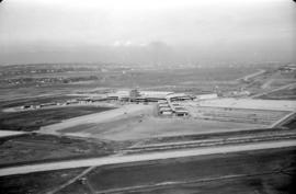
Aerial view of airport terminal, runways and approaches to Sea Island
Aerial view of airport terminal, runways and approaches to Sea Island

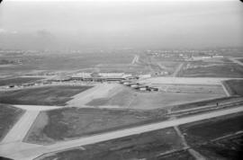
Aerial view of airport terminal, runways and approaches to Sea Island