![[C.N.R. steamship "Prince David" passing Prospect Point in First Narrows]](/uploads/r/null/a/6/a65fe054f2939696a81f4b6acb835a081f437ead75ab0791e35b4effa3bf65bf/81cb124f-e3ff-4ca5-9aa5-abedb752292c-A23810_142.jpg)
[C.N.R. steamship "Prince David" passing Prospect Point in First Narrows]
- AM54-S4-: Bo P59
- Item
- [ca. 1930]
Part of Major Matthews collection
Photo shows view taken from shore of West Vancouver.
447 results with digital objects Show results with digital objects
[C.N.R. steamship "Prince David" passing Prospect Point in First Narrows]
Part of Major Matthews collection
Photo shows view taken from shore of West Vancouver.
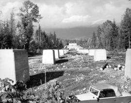
![[Collapse of Capilano Creek bridge]](/uploads/r/null/c/1/c16473dce57398c733523d33683bdfe52f8e9d4ba8d566278e55274267468357/65f1f3fa-08b9-49c9-abd7-ca0ec1ffb661-A24502_142.jpg)
[Collapse of Capilano Creek bridge]
Part of Major Matthews collection
![[Collapse of the Capilano Creek (River) bridge]](/uploads/r/null/6/e/6e56ae40a9fe4beb643b20db36a23c99034bb5f5a8d8eb18f935c186e10e3669/4fc2c8f4-5dc5-407a-b666-2d1f686edd49-A63120_142.jpg)
[Collapse of the Capilano Creek (River) bridge]
Part of Major Matthews collection
![[Collapse of the Capilano Creek (River) bridge]](/uploads/r/null/0/6/06f9274d0513c230cd58241c8f3e62b9cea580597303e4a4ae20a757b0271e20/bcecd925-cfd2-4704-87cf-197c08f6b4b8-A63121_142.jpg)
[Collapse of the Capilano Creek (River) bridge]
Part of Major Matthews collection
Part of Major Matthews collection
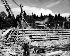
Concrete foundations of North Shore bridge-cable anchorage, sunk to a depth of thirty-five feet.
Part of Major Matthews collection
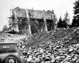
Part of Major Matthews collection
![[Construction of] 3260 Thompson Crecent, Westmount, West Vancouver](/uploads/r/null/3/a/3a69d8c1aea3016bbfa0d3cbcdb5a283098341b475f88c9e8df40be1b009ea7b/20c35d13-d550-42b7-bfea-a0db3c27638e-A71112_142.jpg)
[Construction of] 3260 Thompson Crecent, Westmount, West Vancouver
Part of Major Matthews collection
Snapshot of construction of home for Richard and Hazel Valentia Abbott.
![[Coronation display over the parking lot at Park Royal Shopping Centre]](/uploads/r/null/2/e/2e78669158e409d51bbff524fdcbc90f61e37dc46a9e5dd5952efb90945cfb07/6de3cdf7-cc52-4f73-a008-a7372d4adfb5-A31853_142.jpg)
[Coronation display over the parking lot at Park Royal Shopping Centre]
Part of Major Matthews collection
Cottages to community : the story of West Vancouver's neighbourhoods

Covered bulk storage of sulphur on the north shore of Burrard Inlet
Part of Vancouver Express fonds
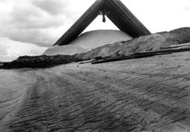
Covered bulk storage of sulphur on the north shore of Burrard Inlet
Part of Vancouver Express fonds

Item is a postcard printed with an image of one of the Canadian Pacific Railway Company's coastal service steamships, the Princess Patricia, passing under the Lions Gate Bridge.
![C.P.R. Princess Patricia[.] On triangle run between Seattle, U.S.A., Victoria and Vancouver, Canada.](/uploads/r/null/f/b/7/fb7441754f9fc1d275437a1d5193eb3118f843dff409135ac47ec5582f404c41/44aaa029-cad1-4e68-b7d1-9cec0fbe7e7b-AM1052P-153_142.jpg)
C.P.R. Princess Patricia[.] On triangle run between Seattle, U.S.A., Victoria and Vancouver, Canada.
Item is a postcard printed with an image of the Princess Patricia, one of the Canadian Pacific Railway Company's coastal service steamships, passing under the Lions Gate Bridge.

Cypress Creek, West Vancouver, with group of hikers in distance
Part of Samuel H. Logan fonds

Part of James Crookall fonds

Part of Major Matthews collection

Dial map of Greater Vancouver and suburbs
Part of City of Vancouver Archives technical and cartographic drawing collection
Part contains a street map of Vancouver, Burnaby, New Westminster, West Vancouver and North Vancouver showing block numbers, street car, bus, and railway lines, parks and hospitals. Map includes two dials (a numbered circle, a paper indicator, a grid of block numbers and a street index used to find locations). A small inset map shows the Capitol Hill/Scenic Park area of Burnaby in greater detail.

Dial map of Greater Vancouver and suburbs
Part of City of Vancouver Archives technical and cartographic drawing collection
Part contains a street map of Vancouver, Burnaby, New Westminster, West Vancouver and North Vancouver showing block numbers, street car, bus, and railway lines, parks and hospitals. Map includes two dials (a numbered circle, a paper indicator, a grid of block numbers and a street index used to find locations). A small inset map shows the Capitol Hill/Scenic Park area of Burnaby in greater detail.

Dial map of Greater Vancouver and suburbs
Part of City of Vancouver Archives technical and cartographic drawing collection
Part contains a street map of Vancouver, Burnaby, New Westminster, West Vancouver, and North Vancouver showing railways, hospitals, parks and block numbers. The map includes two dials (numbered circles, paper indicators, a grid of block numbers and a street index used to find locations).
Dial map of the city of Vancouver including the adjacent municipalities
Part of City of Vancouver Archives technical and cartographic drawing collection
Item is a street map showing Vancouver, Burnaby, New Westminster, West Vancouver and North Vancouver on one side and the University Endowment Lands, Surrey, Maillardville, Lulu Island and Sea Island on the other.
Dial map of the city of Vancouver including the adjacent municipalities
Item is a street map showing Vancouver, Burnaby, New Westminster, West Vancouver and North Vancouver on one side and the University Endowment Lands, Surrey, Maillardville, Lulu Island and Sea Island on the other.

[Dignitaries board S.S. "Comox" for preview of new service from Whytecliffe Park to Bowen Island]
Photograph shows (L to R): Major P.A. Currie, General Manager British Pacific Properties, Harold Brown, Chairman of the Board Union S.S., Hugh Kirkup, President Junior Board of Trade.

Photograph shows Reeve J. B. Leyland, James S. Eckman and others
![[Dock at Whytecliff Park]](/uploads/r/null/9/0/90a5c7170cd4d24785e328b5888e4b943e290205ee4f6bbfe41f0421686d55aa/81e6b9d0-cad0-400e-b5e4-bdcbd0df35ec-A47238_142.jpg)

Part of Major Matthews collection
The map is a draft of MAP 56.01, "Indian villages and landmarks, Burrard Inlet and English Bay, before the whiteman came." It shows the geographic area bounded by the north shore of Burrard Inlet, the Freaser River, Point Atkinson, and the Burrard Inlet Second Narrows. Shown on the map are locations of First Nations and European settlements, streams, coastal features, and inland vegitation. Physical features are labeled using both First Nations and European place names.

Draft map of Indian villages and landmarks, Burrard Inlet and English Bay, before the whiteman came
Part of Major Matthews collection
The map is a draft of map 56.01, "Indian villages and landmarks, Burrard Inlet and English Bay, before the whiteman came." It shows the geographic area bounded by the north shore of Burrard Inlet, the Fraser River, Point Atkinson, and the Burrard Inlet Second Narrows. Shown on the map are coastal sites labeled with First Nations place names.
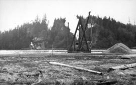
Dredge getting depth on North Shore for basin for anchorage scows carrying building material
Part of Major Matthews collection
Photograph shows the Prospect Point signal station
Dyke residence : West Vancouver
Part of C.B.K. Van Norman fonds
File consists of the following types of architectural drawings: elevations, floor plans and structural specifications.

Part of Stuart Thomson fonds
Part of Stuart Thomson fonds

Part of Stuart Thomson fonds

Part of James Crookall fonds

Part of Stuart Thomson fonds
Part of Stuart Thomson fonds

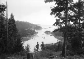
Eagle Harbour, old logging buildings
Part of Hubert William Lovell fonds
Photograph was taken in the summer.
E.L. McPherson residence : [West Vancouver?]
Part of C.B.K. Van Norman fonds
File consists of the following types of architectural drawings: cross section, elevation, floor plan, and structural specifications and plot plans.

English Bay, Point Grey in forest
Part of Major Matthews collection
Photograph shows a view from West Vancouver across the water
![[Entrance to grounds at Whytecliff Park]](/uploads/r/null/4/8/2/4826250da7e22912c7665d47efaf908161a560bae250c585c3fca10ecadc09ec/7594bd52-0c4c-4aa0-bb05-e2a3cc6bbae0-CVA374-459_142.jpg)
[Entrance to grounds at Whytecliff Park]
![[Entrance to Whytecliffe Park on Marine Drive above Batchelor Bay]](/uploads/r/null/c/4/c441051a7d56e18d0d5e15b8696b185d65a619fea84eaa7021777b04e5da5bc5/14fe946c-2293-4553-864f-03a99cbc9c66-A09901_142.jpg)
[Entrance to Whytecliffe Park on Marine Drive above Batchelor Bay]
Part of Major Matthews collection
![[Exterior of first house at Caulfield]](/uploads/r/null/f/4/f41bfbbab0339cffd2a93f1f3b9486b2d4b89ed1fa383d507e1fd33717bb90a4/76cdc763-c9e3-43c5-b079-78e3e132b4d6-A26850_142.jpg)
[Exterior of first house at Caulfield]
Part of Major Matthews collection
![[Exterior of first house at Caulfield]](/uploads/r/null/b/e/bef25ec1e63888210861447f40dc01d26cbf5a76db9957d177c541170fa35300/bc29b75b-dcb2-40d7-b011-49a23206663b-A26851_142.jpg)
[Exterior of first house at Caulfield]
Part of Major Matthews collection
Photograph shows Mrs. Caulfield, Lady Lapier and her daughter
![Exterior of West Vancouver [Municipal] Bus](/uploads/r/null/c/b/cb56c540e682f215563b1eddd0708c34215c335a18653160a5d310b96d06be0d/345a0f50-2af0-4708-bc8e-9b1bcbf9b28c-A18745_142.jpg)
Exterior of West Vancouver [Municipal] Bus
Part of Stuart Thomson fonds
![[Ferry launch "Bowen" leaving Whytecliff dock]](/uploads/r/null/d/f/df382b078cfe01c8216f474845d75dcbf77fe8cb6ed45ebdcc0feb094476c99a/319f266b-0fd3-49dd-9c05-20c6d32fb3ec-A49845_142.jpg)
[Ferry launch "Bowen" leaving Whytecliff dock]
Photograph shows Standard Oil filling station on a R.C.A.F. raft

Photograph shows the Union Steamer "Comox"