E.B. Hermon residence, Vancouver Heights [Burnaby]
- AM1015-F09
- File
- Apr. 1911
Part of Ross A. Lort, Architect fonds
343 results with digital objects Show results with digital objects
E.B. Hermon residence, Vancouver Heights [Burnaby]
Part of Ross A. Lort, Architect fonds
![[Aerial view looking west over Burnaby towards Vancouver]](/uploads/r/null/3/e/3ee0bad707202c9fbcaad91d585345ec93cbe9ec0be93643a8c82dd4f323bdde/1d10f88f-abea-4b79-b07a-e27dfe5d6cd0-A71608_142.jpg)
[Aerial view looking west over Burnaby towards Vancouver]
Oblique view showing the former Kelly Douglas site (now Metrotown Mall), Kingsway and Central Park
![[Aerial view looking west over Burnaby towards Vancouver]](/uploads/r/null/a/1/a1972aaa0fedf64a8da64c0a3f99647764ec26034813d610dc060d54afdfe1bf/0b1d7503-6b52-44de-a829-67274f54d77c-A71609_142.jpg)
[Aerial view looking west over Burnaby towards Vancouver]
Oblique view showing the former Kelly Douglas site (now Metrotown Mall), Kingsway and Central Park
![[Aerial view over Burnaby]](/uploads/r/null/0/3/037ecb1cc7577fad52b33cbaec0eaf096ffaba433660c44f741e17d03dfdfabd/2b0ca722-06fa-4545-9dc1-41843e30b8ec-A71610_142.jpg)
Oblique view showing the area between Canada Way, Sumner Avenue, Willingdon Avenue and the Trans Canada Highway including the Villa Inn and a hotel under construction
![[Aerial view over Burnaby]](/uploads/r/null/0/0/000c0196f6c810d76eb723bd8a3264ee3e43b53d6e32e7ad08a8e01e6712e7d7/75a245f8-8a3d-404d-bc50-219fadd7d908-A71611_142.jpg)
Oblique view showing the area between Canada Way, Sumner Avenue, Willingdon Avenue and the Trans Canada Highway including the Villa Inn and a hotel under construction
![[Aerial view over Burnaby]](/uploads/r/null/3/3/331b6e68239af4202f445b5284f51f9a4cb22c20b12ed83ca8ea7f7333df1d07/025da952-0a47-40b0-8988-6a3f80af1576-A71612_142.jpg)
Oblique view showing the area between Canada Way, Sumner Avenue, Willingdon Avenue and the Trans Canada Highway including the Villa Inn and a hotel under construction
![[Aerial view looking northwest towards the Downtown waterfront]](/uploads/r/null/c/c/cc62f979c7614b3405e2bfbfcd8cf6172232e958fc2dcd17a970dbbf3d28b4d8/4699d55d-d238-4161-854b-fa983bd7d738-A71613_142.jpg)
[Aerial view looking northwest towards the Downtown waterfront]
Oblique view showing Harbour Centre (formerly Spencer's Department Store) and Lookout, the C.P.R. (Waterfront) Station, C.P.R. Pier B-C, the Marine and other buildings
![[Aerial view looking over the Downtown waterfront]](/uploads/r/null/1/6/1644eebceda09466c9aac6a8534ea82b04164ab39d5d756ec4cc902d5ba16e30/d4c9f855-498d-4971-a368-0f672d3a89a4-A71614_142.jpg)
[Aerial view looking over the Downtown waterfront]
Oblique view showing Burrard Street and the Marine and other buildings
Dial map of the city of Vancouver including the adjacent municipalities
Part of City of Vancouver Archives technical and cartographic drawing collection
Item is a street map showing Vancouver, Burnaby, New Westminster, West Vancouver and North Vancouver on one side and the University Endowment Lands, Surrey, Maillardville, Lulu Island and Sea Island on the other.
Sectional map and street directory of Vancouver : Dial map of the city of Vancouver
Part of City of Vancouver Archives technical and cartographic drawing collection
Item is a street map showing Vancouver on one side and Burnaby and New Westminster on the other, as well as information on street car and bus routes, and text advertising the products and services of the Dominion Map and Blueprint Company.
![People's Trust Co. - house [7649 Berkley Street, Burnaby, B.C.]](/uploads/r/null/2/d/2d57bfe96ba3d02b8c76e6259e206c1612f12a25150d3765860ea49b12ca785f/898ad27c-96a6-4788-9768-989ceb163767-A02748_142.jpg)
People's Trust Co. - house [7649 Berkley Street, Burnaby, B.C.]
Part of Stuart Thomson fonds
The house is also known as the Joseph and Jane Wintemute House. The house was offered as a promotional prize by the Peoples Trust Company when they were selling a subdivision called Montrelynview (now Buckingham Heights).
![[Mrs. Quiney with Theresa, James, Ken and Rose in the snow at Pender Street and Ingleton Avenue.]](/uploads/r/null/8/8/880ae2d7d8c0779914dab1dd1617f3325e9ba99e4163a52cff1ff2720831d12f/4f0436d8-b192-47d3-b975-5629166b5475-A20317_142.jpg)
[Mrs. Quiney with Theresa, James, Ken and Rose in the snow at Pender Street and Ingleton Avenue.]
Part of James Luke Quiney fonds

Garden of Mr. and Mrs. Quiney, 4916 Union Street, Burnaby
Part of James Luke Quiney fonds
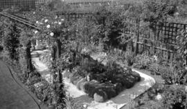
Garden of Mr. and Mrs. Quiney, 4916 Union Street, Burnaby
Part of James Luke Quiney fonds
![[Delphiniums display]](/uploads/r/null/e/d/ed7d9cb4485814eb1456b0fde1385c364ee9f22232eb4265a38fd3c1d2cb9eda/79fce68c-47d6-4d6e-88ad-d5c4fe69607a-A20479_142.jpg)
Part of James Luke Quiney fonds
Item is a photograph of delphiniums and a sign reading "Winston Churchill". Major Matthews notes on the negative read " Delphiniums. 1930. Grown by Jas. L Quiney, 4916 Union St."
![James L. Quiney [in front of delphiniums at] 4916 Union Street, Burnaby](/uploads/r/null/0/8/08d8eb101354a5af4ffc287489f03afea48c64e6ef88806a5ea2c631fbbdae12/3cf19ab4-87e6-4a0c-96fe-c4522c7f8a64-A20480_142.jpg)
James L. Quiney [in front of delphiniums at] 4916 Union Street, Burnaby
Part of James Luke Quiney fonds
Item is a photograph showing James Quiney standing in front of his delphiniums. The negative has been annotated by Major Matthews with "Jas. L. Quiney, 1930, 4916 union St. Six feet five inches tall. His delphiniums over eleven feet; six feet bloom; flowers size of cup."
![[James L. Quiney with delphiniums at 4916 Union Street, Burnaby]](/uploads/r/null/c/3/c3fdd23b8f7784cd83aeecbb66e1c0b2ab7a63f22d66ab67645ddbac1e2d7201/c906c0d8-906f-4591-b10e-68a2bc1832de-A20481_142.jpg)
[James L. Quiney with delphiniums at 4916 Union Street, Burnaby]
Part of James Luke Quiney fonds
Delphiniums are about eleven feet high with blooms at six feet.
![[James L. Quiney with delphiniums at 4916 Union Street, Burnaby]](/uploads/r/null/5/b/5b3346e9ffd324197f5e2037c1d5f58ce0da785dcae8dfa34e26e31868ca2f84/84fa78f5-2ca8-4dab-a308-00295fbd421a-A20482_142.jpg)
[James L. Quiney with delphiniums at 4916 Union Street, Burnaby]
Part of James Luke Quiney fonds
![Mr. and Mrs. James L. Quiney [in the garden at] 4916 Union Street, Burnaby](/uploads/r/null/2/b/2b14a4475f159c8724c464066521fd10b5ce8a560e131d8b8821d829aae11195/39a6debe-8246-4dd2-8e70-677b9209933d-A20483_142.jpg)
Mr. and Mrs. James L. Quiney [in the garden at] 4916 Union Street, Burnaby
Part of James Luke Quiney fonds
![Mr. and Mrs. James L. Quiney [in the garden at] 4916 Union Street, Burnaby](/uploads/r/null/d/7/d7da9e4f03d77c85bd288a34fce2a360eb89f9658ac52e7262db8a5c3b15aca8/f55deca0-b872-42f7-8f94-e1691ae8ab3d-A20484_142.jpg)
Mr. and Mrs. James L. Quiney [in the garden at] 4916 Union Street, Burnaby
Part of James Luke Quiney fonds
![[Aerial photograph of north Burnaby near intersection of Lougheed and Sperling]](/uploads/r/null/0/4/0402a7c6f7e8a28c8ca96ea5b930f8be591de0a42bfa4e4d588b57d8242e3df2/89b183bb-b4c9-4610-bd3d-233b78ca3218-A38735_142.jpg)
[Aerial photograph of north Burnaby near intersection of Lougheed and Sperling]
![[Aerial photograph of north Burnaby near intersection of Lougheed and Sperling]](/uploads/r/null/f/6/f6d5ee2897afb7fca08a02c5516b73fa64f9dffc0b96e41335272f5049bff318/5e860ead-2105-466e-9535-74449508fa1c-A38734_142.jpg)
[Aerial photograph of north Burnaby near intersection of Lougheed and Sperling]
![[Aerial photograph of north Burnaby near intersection of Lougheed and Sperling]](/uploads/r/null/a/c/acb6598698ac88b27910cc65b590d05b02972403e78fecc5ae1a368cd0c4886b/32a0806e-9249-4407-8edf-f969bf2582fb-A38736_142.jpg)
[Aerial photograph of north Burnaby near intersection of Lougheed and Sperling]
![[The wreck of Great Northern Railway train and engine No. 202 near Burnaby Lake]](/uploads/r/null/8/c/8c120a4630e58ec6d8ede7b74872a099c2d81d36816091c5d03a7f59f92b5a8d/05948ab1-0906-4e2d-adcd-79b1683f14b6-A62610_142.jpg)
[The wreck of Great Northern Railway train and engine No. 202 near Burnaby Lake]
Part of Major Matthews collection
![[Kingsway at Boundary Road]](/uploads/r/null/0/9/092e433ed069d0ecb5f976ae7ab9930590d2abef0adbcf8e8ae2041c60e2f24b/4ef6a8b6-f153-4441-910f-bc7c3b47eb88-A20219_142.jpg)
Part of Major Matthews collection
Photograph shows a billboard in the distance
![Kingsway and Patterson [Avenue]](/uploads/r/null/f/2/f2482c3a28fb03b5dd4931ccb7b2cfb3022990487fc3eac2951094a54da18e47/d5869bda-5313-4cd4-ab2a-68e9b5c55d86-A20220_142.jpg)
Kingsway and Patterson [Avenue]
Part of Major Matthews collection
Photograph shows a Ruddy-Duker Company billboard advertising The Camrin and Vance Hotel in Seattle
![Kingsway and Edmonds [Street on] north side city incoming](/uploads/r/null/b/a/ba05eda748307a0827332472c9e29aefd0c0dcb584ad376dbb0cf23bf857d13f/55eb2571-bf7e-4654-9630-fe4ce969b767-A20214_142.jpg)
Kingsway and Edmonds [Street on] north side city incoming
Part of Major Matthews collection
Photograph shows a billboard advertising Ingledew's and the Richfield Garage
Sectional map and street directory of Vancouver : Dial map of the city of Vancouver
Item is a street map showing Vancouver on one side and Burnaby and New Westminster on the other, as well as information on street car and bus routes, and text advertising the products and services of the Dominion Map and Blueprint Company.
![C.J. Piper's cottage [at] Piper [Avenue] North Burnaby [south of G.N. tracks]](/uploads/r/null/9/a/9a3383533a82a10784f197733a8bbe77d594580610fe4d659cc365be4f3bd7ee/a443bbf3-a683-4860-81b7-20db56c2cfcf-A46620_142.jpg)
C.J. Piper's cottage [at] Piper [Avenue] North Burnaby [south of G.N. tracks]
Part of Major Matthews collection
![C.J. Piper's cottage [on] Piper [Avenue] North Burnaby south of G.N. tracks](/uploads/r/null/7/4/74c4ace93d1630f4d7e6731aa8a13ebff0f61bb1aedb18c09022c4149782ef62/6b4d01af-231f-4c66-9be0-fe8c5a706956-A46621_142.jpg)
C.J. Piper's cottage [on] Piper [Avenue] North Burnaby south of G.N. tracks
Part of Major Matthews collection
![C.J. Piper's cottage [on] Piper [Avenue near] Burnaby Lake](/uploads/r/null/5/a/5afaa36920167f8ea5bae3dbea35cb9278c732e2acb87068462fe7f2c7b36866/47ff0806-eaa5-4cc5-bbf2-f1de5a74120c-A46622_142.jpg)
C.J. Piper's cottage [on] Piper [Avenue near] Burnaby Lake
Part of Major Matthews collection
![[Creek near] C.J. Piper's cottage [on] Piper [Avenue] south of G.N.R. track North Burnaby](/uploads/r/null/b/0/b07a3a285c36eeb39d1a022d09cfd4079ebdb5c56421cae66bda8e85b95e3c9f/f1ccade7-c066-4825-84be-c0de420f1c9e-A46623_142.jpg)
[Creek near] C.J. Piper's cottage [on] Piper [Avenue] south of G.N.R. track North Burnaby
Part of Major Matthews collection

Piper floating wharf at foot of Piper Avenue south of G.N. track North Burnaby
Part of Major Matthews collection

Piper Avenue looking south to Burnaby Lake
Part of Major Matthews collection
![Piper Mill, Piper Siding [near] Great Northern Railway](/uploads/r/null/1/d/1d9a0aba9c7f1ffd1a3f41724bc058318e250a59b4b2f4d41d42f9149bb900be/c48c5164-6f25-491b-99a1-51422353e29c-A46626_142.jpg)
Piper Mill, Piper Siding [near] Great Northern Railway
Part of Major Matthews collection
![Piper Mill, Piper Siding [near] Great Northern Railway](/uploads/r/null/c/9/c90e447850ff00fc2c98215222bc129f027332096635eb40c3fc528ed17fb5ae/270dc2c7-b4a4-43b7-b16f-931ca52bcf05-A46627_142.jpg)
Piper Mill, Piper Siding [near] Great Northern Railway
Part of Major Matthews collection

Great Northern Railway track (from New Westminster to Vancouver) at Piper Mill, Piper Siding
Part of Major Matthews collection
![[Meal served at Oakalla prison]](/uploads/r/null/2/7/27752c0f754fd773ae2cc6e29935cf6f346781c443b852eae0cf9413d33fdfaf/d174a04e-d9a2-496c-a89d-a4f906db6355-A12625_142.jpg)
[Meal served at Oakalla prison]
![[Interior view of the library at Oakalla prison]](/uploads/r/null/6/6/66182ea62b4ac548526033cf052ad91bdc4fc5a1837d2d2a7a84cbabd612b3f7/03ce81e2-d420-4753-83a5-5650481e64af-A12624_142.jpg)
[Interior view of the library at Oakalla prison]
![[Interior view of a jail cell at Oakalla prison]](/uploads/r/null/8/0/8015d880e11144ebc60c774a5c9a535fc6959b7a48483e481a397514c87a69f6/dea1a9c7-0b76-4407-8da5-c65421d27330-A12623_142.jpg)
[Interior view of a jail cell at Oakalla prison]
![[Oakalla prison uniform laid out on a table]](/uploads/r/null/2/5/25891445b38bcad05cbedf036916b9037ffdd80be8735bcf46befbaacb6f52c9/a9167112-3815-41d8-9a6b-aabc85f83c3f-A12622_142.jpg)
[Oakalla prison uniform laid out on a table]

Dial map of Greater Vancouver and suburbs
Part of City of Vancouver Archives technical and cartographic drawing collection
Part contains a street map of Vancouver, Burnaby, New Westminster, West Vancouver, and North Vancouver showing railways, hospitals, parks and block numbers. The map includes two dials (numbered circles, paper indicators, a grid of block numbers and a street index used to find locations).

Dial map of Greater Vancouver and suburbs
Part of City of Vancouver Archives technical and cartographic drawing collection
Part contains a street map of Vancouver, Burnaby, New Westminster, West Vancouver and North Vancouver showing block numbers, street car, bus, and railway lines, parks and hospitals. Map includes two dials (a numbered circle, a paper indicator, a grid of block numbers and a street index used to find locations). A small inset map shows the Capitol Hill/Scenic Park area of Burnaby in greater detail.

Map of Burnaby and New Westminster, British Columbia
Part of City of Vancouver Archives technical and cartographic drawing collection
Part consists of a street map of Burnaby and New Westminster, information on bus and street car routes, and text advertising the products and services of the Dominion Map and Blueprint Company.

City of Vancouver : Canadian Pacific town site
Part of City of Vancouver Archives technical and cartographic drawing collection
Part contains four maps. The main map shows district lots and block numbers in Vancouver from Vine Street in the west to Boundary Avenue (Glen Drive) in the east and Stanley Park in the north to 9th Avenue (Broadway) in the south. Three smaller maps include an index plan to district lots in Vancouver, South Vancouver, New Westminster, and Burnaby; a world map showing Canadian Pacific mail steamship lines; and an index plan of Vancouver city limits.

Part of James Crookall fonds

Part of James Crookall fonds
Photograph shows a view at night from Burnaby Heights looking west to the harbour
![[Cars in lane near James Crookall's home in Burnaby Heights]](/uploads/r/null/8/d/8dfa35a086ab107c4743b1a887929b56fa47a5d3ab3c53a59de8f49565d95852/7da10e5f-57c6-4794-9231-d076b941e730-A74426_142.jpg)
[Cars in lane near James Crookall's home in Burnaby Heights]
Part of James Crookall fonds
![[Looking west from Burnaby Heights showing the sun streaming through the clouds]](/uploads/r/null/6/9/69d1909058c0ea90a95343eba4b8826ecf60cb2453a11f2450f18228e01c4b96/52e79cb1-e8f7-404f-aa64-a46f3934b223-A74446_142.jpg)
[Looking west from Burnaby Heights showing the sun streaming through the clouds]
Part of James Crookall fonds
![[Rear of houses from James Crookall's house in Burnaby Heights]](/uploads/r/null/0/f/0f7e9c4ff37c2aaef194e3042e6dba7ea1283933df91b16dc9401780e2d2a184/cc9aac3d-ef77-4a6b-b0d0-ec8ea9a1732a-A75563_142.jpg)
[Rear of houses from James Crookall's house in Burnaby Heights]
Part of James Crookall fonds