
- COV-S597-F1-: 2019-102.01
- Item
- July 1973
Part of City of Vancouver fonds
208 results with digital objects Show results with digital objects
Part of City of Vancouver fonds

Part of City of Vancouver fonds

Part of City of Vancouver fonds

Part of City of Vancouver fonds

Part of City of Vancouver fonds
Item is a photograph showing a City plaque for the False Creek Shoreline project.

Part of City of Vancouver fonds
Item is a photograph showing a new path and cleared area for the seawall. Buildings are visible in the background including the Sigurdson Millwork Co. located at 1275 West 6th.

Part of City of Vancouver fonds
Item is a photograph showing the marina looking northwest with the Burrard Bridge in the background.

Part of City of Vancouver fonds
Item is a photograph showing the seawall under construction.

Part of City of Vancouver fonds
Item is a photograph showing the seawall under construction.

Part of City of Vancouver fonds
Item is a photograph showing the seawall under construction.

Part of City of Vancouver fonds
Item is a photograph showing the seawall under construction.

Part of City of Vancouver fonds
Item is a photograph showing the seawall under construction.

Part of City of Vancouver fonds
Item is a photograph showing wood debris in the water.
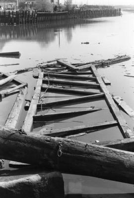
Part of City of Vancouver fonds
Item is a photograph showing wood debris in the water.

Part of City of Vancouver fonds

Part of City of Vancouver fonds
Item is a photograph showing wood debris in the water. Businesses Spear & Jackson BC Ltd. and Tyee Machinery Co. Ltd. and the Granville Bridge are in the background.

Part of City of Vancouver fonds

Part of City of Vancouver fonds
Item is a photograph showing buildings and roadwork under construction.

Part of City of Vancouver fonds
Item is a photograph showing buildings and roadwork under construction.

Part of City of Vancouver fonds
Item is a photograph showing an aerial view from Spruce Street to Burrard Street, West 6th Avenue, and the north side of False Creek. Includes Granville Street Bridge, Granville Island and the Burrard Street Bridge.
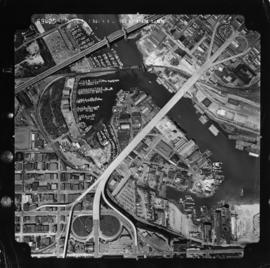
Part of City of Vancouver fonds
Item is a photograph showing an aerial view from Oak Street to Pine Street, West 6th Avenue, and the north side of False Creek. Includes Granville Street Bridge, Granville Island and the Burrard Street Bridge.

Part of City of Vancouver fonds
Item is a photograph showing the east end of False Creek. From just west of Columbia Street to just east of Main Street, West 2nd Avenue to Keefer Street. Includes the Georgia Viaduct and Dunsmuir Viaduct.
Part of City of Vancouver fonds
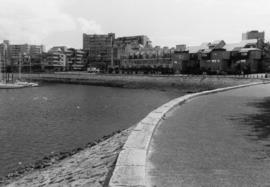
Item is a photograph showing a view of an area of the seawall between Stamp's Landing and Cambie Bridge (street unnamed).

Part of City of Vancouver fonds
Item is a photograph showing a view of the seawall from Charleson Park.

Part of City of Vancouver fonds
Item is a photograph showing a view of the seawall from Charleson Park.

Part of City of Vancouver fonds
Item is a photograph showing a view of the seawall from Charleson Park.

Part of City of Vancouver fonds
Item is a photograph showing the marina looking northwest with the Burrard Bridge in the background.

Part of City of Vancouver fonds
Item is a photograph showing a view of the seawall from Charleson Park.

Part of City of Vancouver fonds
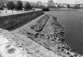
Item is a photograph showing a close up view of the seawall.

Part of City of Vancouver fonds
Item is a photograph showing a view of the seawall from Charleson Park.
Part of City of Vancouver fonds
Item is a photograph showing a view of the seawall looking east from the 800 block of Millbank Street.

Part of City of Vancouver fonds
Item is a photograph showing a view of the seawall looking east from the 800 block of Millbank Street.

Part of City of Vancouver fonds
Item is a photograph showing a close up view of the seawall.

Part of City of Vancouver fonds
Item is a photograph showing a close up view of the seawall.

Part of City of Vancouver fonds
Item is a photograph showing the seawall at Millbank Street and Ferry Row.

Part of City of Vancouver fonds
Item is a photograph showing the seawall at Millbank Street and Ferry Row.

Part of City of Vancouver fonds
Item is a photograph showing a the seawall and boats in the marina.

Part of City of Vancouver fonds
Item is a photograph showing the seawall at Leg-In-Boot Square.

Part of City of Vancouver fonds
Item is a photograph showing a close up view of the seawall at the 1500 block of Island Park Walk.

Part of City of Vancouver fonds
Item is a photograph showing a close up view of the seawall at the 1500 block of Island Park Walk.

Part of City of Vancouver fonds
Item is a photograph showing the view from Anderson Street at Granville Island looking west towards the 1500 block of Island Park Walk. Boats are also shown in Fishermen's Wharf.

Part of City of Vancouver fonds
Item is a photograph showing the seawall and Fishermen's Wharf.

Part of City of Vancouver fonds
Item is a photograph showing the view from the seawall at the 1500 block of Island Park Walk. Boats are also shown in Fishermen's Wharf.

Part of City of Vancouver fonds
Item is a photograph showing a the seawall and boats in the marina.

Part of City of Vancouver fonds
Item is a photograph showing the seawall at 1000-1100 Ironwork Passage. BC Place is visible in the background.

Part of City of Vancouver fonds
Item is a photograph showing a the seawall and boats in the marina.

Part of City of Vancouver fonds
Item is a photograph showing a close up view of the seawall.

Part of City of Vancouver fonds
Item is a photograph showing a close up view of the seawall.

Part of City of Vancouver fonds
Item is a photograph showing a view from the Stamp's Landing area with moored boats and BC Place visible in the background.

Part of City of Vancouver fonds
Item is a photograph showing the seawall at Foundry Quay.