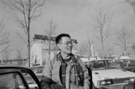
Paul Yee at a parking lot at Granville Island
- AM1523-S6-F23-: 2008-010.1375
- Item
- 1986
Part of Paul Yee fonds
208 results with digital objects Show results with digital objects
Paul Yee at a parking lot at Granville Island
Part of Paul Yee fonds

Paul Yee carrying a Michael Yee on his shoulders at Charleson Park
Part of Paul Yee fonds
Item is a photograph showing Paul Yee carrying his nephew, Michael Yee.
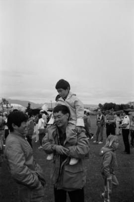
Paul Yee carrying Michael Yee on his shoulders at Charleson Park
Part of Paul Yee fonds
Item is a photograph showing Paul Yee carrying his nephew, Michael Yee, on his shoulders and talking to another unidentified man.

People assembled around Chevron Stage during Fool's Day event

People assembled around Chevron Stage during Fool's Day event

Performance celebrating Vancouver Day at the Expo Site

Performance celebrating Vancouver Day at the Expo Site

Performance for Yokohama Day at Expo Site

Performance for Yokohama Day at Expo Site

Performer on stilts wearing "Miss Expoo" sash at Fool's Day event

Performer on stilts wearing "Miss Expoo" sash at Fool's Day Parade

Performer on stilts wearing "Miss Expoo" sash at Fool's Day Parade

Performers on stage at Fool's Day Parade

Performers on stage at Fool's Day Parade

Performers on stage at Fool's Day Parade

Performers on stage at Fool's Day Parade
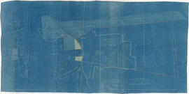
Plan of False Creek, Vancouver, B.C.
Part of City of Vancouver Archives technical and cartographic drawing collection
Map shows streets, railways, land to be reclaimed, foreshore applied for, foreshore granted by order in council, proposed wharf lines, areas to be dredged and land ownership in and along False Creek. A key map in the top right-hand corner shows the location of False Creek in relation to the rest of Vancouver.

Plan of sea wall site, Main Street, and surrounding properties
Part of City of Vancouver fonds
Item is a map showing sewers, pier headlines, land ownership, streets, parks and rail lines in the area east of False Creek at Main Street and Terminal Avenue.

Part of City of Vancouver Archives technical and cartographic drawing collection
Item is a map showing major landmarks, railway lines, harbour lands reclaimed, proposed wharves and piers, retaining walls and dredging, and soundings in fathoms in Vancouver Harbour (Burrard Inlet) and False Creek.
Part of William McNeill fonds
Item is a survey plan showing the layout of buildings on a section of reclaimed land where Carrall Street meets False Creek, and property ownership in adjacent areas. An index plan shows the location covered by the main map in relation to the surrounding area.
![Plan shewing location of sewers on C.P.Rly. [Canadian Pacific Railway] industrial sites](/uploads/r/null/7/6/1/7619e437193646086fba2c0b959aeb02c1226500076d36df8da8fa5f9e9388e9/b1d0ba23-309d-48e1-a012-2b2eb18a2ff8-MAP738_142.jpg)
Plan shewing location of sewers on C.P.Rly. [Canadian Pacific Railway] industrial sites
Part of City of Vancouver fonds
Item is a map showing location of sewers, businesses, and Canadian Pacific Railway buildings on the north side of False Creek from the Granville Street Bridge to the Cambie Street Bridge.

Plan showing foreshore applied for by the British Columbia Mills Timber and Training Company Limited
Part of William McNeill fonds
Item is an original drawing used as part of the base for the survey plan titled "Plan shewing foreshore applied for by the B.C.M.T. and T. Co. Ltd." also found in this file.

Plan showing vicinity of Fisher Case, Nov 9th, 1949
Part of City of Vancouver Archives technical and cartographic drawing collection
Item is a map showing roads, buildings, bridges and railway lines in the False Creek vicinity. Red pencil marks a route occupied by float houses and shacks. Green pencil marks an unidentified route on the map.
Vancouver (B.C.). Engineering Services
Item is a notice of public meeting for December 16, 1969 held by the Citizens Council on Civic Development.
Proposal for the north shore of False Creek
Item is a proposal prepared by Zoltan S. Kiss, Architect for Marathon Realty, and includes a traffic study.
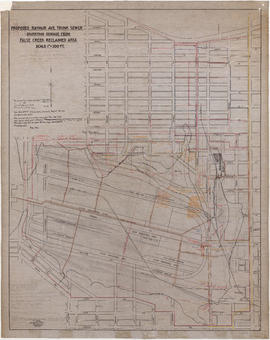
![Proposed Raymur Ave. [Avenue] Trunk Sewer diverting sewage from False Creek reclaimed area](/uploads/r/null/c/d/cddf61ac60b97b6fc54309ecbf8d1aea8e9aac3c672576fbd9953a05b82d42fc/14951fa4-0fd0-480c-a1f3-b7c2ef158398-MAP761_142.jpg)
Proposed Raymur Ave. [Avenue] Trunk Sewer diverting sewage from False Creek reclaimed area
Part of City of Vancouver Archives technical and cartographic drawing collection
Map shows the proposed Raymur Avenue Trunk Sewer to divert sewage away from the False Creek reclaimed area. It includes the area from Main Street to Clark Drive and from Alexander Street to Seventh Avenue. Streets and blocks are shown. The map was heavily annotated between 1936 and 1941, and a preliminary pumping layout to Clark Drive was added in December 1936. Also indicated are the locations of sewers, pumps, drainage and elevations; the Canadian National Railway (C.N.R.) Station, lines, industrial sites and proposed roadways; the Great Northern Railway (G.N.R.) Station and lines; a proposed rail yard; and the City Dump.
![Proposed Raymur Ave. [Avenue] Trunk Sewer diverting sewage from False Creek reclaimed area](/uploads/r/null/5/2/5260099e92441f23442086ea3a8b5f7512bb5b4b4b5cbf554c9f13450bf4d37f/b5165f5d-bd82-46b5-9beb-0f969f7755ef-MAP761_142.jpg)
Proposed Raymur Ave. [Avenue] Trunk Sewer diverting sewage from False Creek reclaimed area
Part of City of Vancouver Archives technical and cartographic drawing collection
Map shows the proposed Raymur Avenue Trunk Sewer to divert sewage away from the False Creek reclaimed area. It includes the area from Main Street to Clark Drive and from Alexander Street to Seventh Avenue. Streets and blocks are shown. The map is annotated in ink and pencil with regard to top and bottom fill and water levels. A pencil diagram of the pump at Parker Street has been drawn at the top of the map. Also indicated are the locations of pumps; the Canadian National Railway (C.N.R.) Station, lines, industrial sites and proposed roadways; the Great Northern Railway (G.N.R.) Station and lines; and the City Dump.
![Proposed Raymur Ave. [Avenue] Trunk Sewer diverting sewage from False Creek reclaimed area](/uploads/r/null/a/8/a8edd70876832fb32ffa8add8b5e261fe78b0e6efcb26d07a6fe1c74bf545b57/ac62eada-955d-4eee-8508-6bf4b71a21e5-MAP761_142.jpg)
Proposed Raymur Ave. [Avenue] Trunk Sewer diverting sewage from False Creek reclaimed area
Part of City of Vancouver Archives technical and cartographic drawing collection
Map shows the proposed Raymur Avenue Trunk Sewer to divert sewage away from the False Creek reclaimed area. It includes the area from Main Street to Clark Drive and from Alexander Street to Seventh Avenue. Streets and blocks are shown. The map is heavily annotated in ink and pencil to 1936. Indicated on the map are the locations of pumps, sewers, drains, and elevations; the Canadian National Railway (C.N.R.) Station, lines, industrial sites and proposed roadways; the Great Northern Railway (G.N.R.) Station and lines; a proposed rail yard; and the City Dump. Also noted is the water consumption of various companies in the area.
Proposed Raymur Ave. trunk sewer diverting sewage from False Creek reclaimed area
Part of City of Vancouver fonds
Item is a map showing detailed plans associated with the Raymur Ave. trunk sewer. The map contains several revisions and updates dated Dec. 1936, Feb. and Mar. 1937, May 1937, Aug. 1938 and Sept. 1941 of utilities infrastructure in False Creek east of Main Street.
Vancouver (B.C.). Engineer's Office

Proposed Raymur Ave. trunk sewer diverting sewage from False Creek reclaimed area
Part of City of Vancouver fonds
Item is a map showing detailed plans associated with the Raymur Ave. trunk sewer. Annotations show the heights of top fill, bottom and water relative to an unidentified benchmark.
Vancouver (B.C.). Engineer's Office

Proposed Raymur Ave. trunk sewer diverting sewage from False Creek reclaimed area
Part of City of Vancouver fonds
Item is a map showing detailed plans associated with the Raymur Ave. trunk sewer. Annotations show sewer lines.
Vancouver (B.C.). Engineer's Office

Proposed system of drainage and sewerage for False Creek and marginal areas
Part of City of Vancouver fonds
Item is a map showing sewers and storm drains in the area from Alexander Street in the north to Seventh Avenue in the south and from Clark Drive in the east to Main Street in the west.
![Ripples on [the water at] False Creek](/uploads/r/null/9/e/5/9e53e82111d0ddf9987cda99b11b7dfdc9b96abc1ccb902c67a51ad986df1abc/6e67b7f7-47c4-4e04-b58d-c55de70a1965-CVA293-028_142.jpg)
Ripples on [the water at] False Creek
![Ripples on [the water at] False Creek](/uploads/r/null/a/a/a/aaad25eb6ed3aff16d6050ddbbc88b8d030e7f546497d91d292cb3f1a1fc8d1f/893f1f6d-cd8a-4d27-a14d-1918361bc538-CVA293-028_142.jpg)
Ripples on [the water at] False Creek
![Ripples on [the water at] False Creek](/uploads/r/null/7/8/e/78e9d23c77105d9f46431a4c490108b47513f71809f50383f3693f464bd6e420/410ab4f5-161d-492a-b1a9-5688415aa8f2-CVA293-028_142.jpg)
Ripples on [the water at] False Creek

Small sailboat in front of high-rises on north shore of False Creek
Part of Vancouver Express fonds

Part of City of Vancouver fonds

Part of City of Vancouver fonds
Item is a photograph showing a City plaque for the False Creek Shoreline project.

Part of City of Vancouver fonds
Item is a photograph showing the seawall under construction.

Part of City of Vancouver fonds
Item is a photograph showing the seawall under construction.
Part of City of Vancouver fonds
Item is a photograph showing a view of an area of the seawall between Stamp's Landing and Cambie Bridge (street unnamed).

Part of City of Vancouver fonds
Item is a photograph showing a view of the seawall from Charleson Park.

Part of City of Vancouver fonds
Item is a photograph showing a view of the seawall from Charleson Park.

Part of City of Vancouver fonds
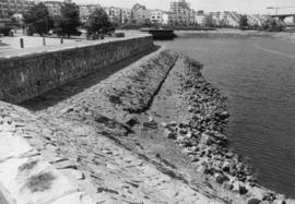
Item is a photograph showing a close up view of the seawall.

Part of City of Vancouver fonds
Item is a photograph showing a close up view of the seawall.

Part of City of Vancouver fonds
Item is a photograph showing the seawall at Millbank Street and Ferry Row.

Part of City of Vancouver fonds
Item is a photograph showing the view from Anderson Street at Granville Island looking west towards the 1500 block of Island Park Walk. Boats are also shown in Fishermen's Wharf.

Part of City of Vancouver fonds
Item is a photograph showing the seawall at 1000-1100 Ironwork Passage. BC Place is visible in the background.

Part of City of Vancouver fonds
Item is a photograph showing the seawall and a partial view of housing along 1100 block of The Castings and Island Park Walk.

Part of City of Vancouver fonds
Item is a photograph showing the seawall under construction.