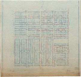
Water service map of South Vancouver : McHardy Street to Park Street (Boundary Road) and Government Street (29th Avenue) to Vanness Avenue
Water service map of South Vancouver : Tyne Street to Park Street (Boundary Road) and Vanness Avenue to 46th Avenue (45th Avenue)
Water service map of South Vancouver : Ontario Street to Fraser Street and 33rd Avenue to 41st Avenue
Water service map of South Vancouver : Knight Street to Victoria Drive and 34th Avenue (33rd Avenue) to 43rd Avenue (41st Avenue)
Water service map of South Vancouver : Ontario Street to Fraser Street and 43rd Avenue (41st Avenue) to 51st Avenue (49th Avenue)
Water service map of South Vancouver : Ontario Street to Fraser Street and 51st Avenue (49th Avenue) to 61st Avenue (59th Avenue)
Water service map of South Vancouver : Knight Street to Victoria Drive and 43rd Avenue (41st Avenue) to 51st Avenue (49th Avenue)
Water service map of South Vancouver : Ash Street to Ontario Street and 61st Avenue (59th Avenue) to River Avenue (Marine Drive)
Water service map of South Vancouver : Point Grey boundary to Ontario Street and River Avenue (Marine Drive S.W.) to North Arm of Fraser River
Water service map of South Vancouver : Ontario Street to Fraser Street and 61st Avenue (59th Avenue) to River Street (Marine Drive S.E.)
Water service map of South Vancouver : Ontario Street to Fraser Street and River Avenue (Marine Drive) to North Arm of Fraser River
Water service map of South Vancouver : Churchill Street (Rupert Street) to Tyne Street and School Road (School Avenue) to 46th Avenue (45th Avenue)
Water service map of South Vancouver : Wales Street to Churchill Street (Rupert Street) and New Westminster Road (Kingsway) to 46th Avenue (45th Avenue)
Water service map of South Vancouver : Fraser Street to Knight Street and 34th Avenue (33rd Avenue) to 43rd Avenue (41st Avenue)
Water service map of South Vancouver : Fraser Street to Knight Street and 61st Avenue (59th Avenue) to North Arm of Fraser River
Indexed guide map of the city of Vancouver and suburbs
Indexed guide map of the city of Vancouver and suburbs : map booklet front cover
Hotels
Street index (Royal Oak Avenue, Vancouver to Frederick Road, North Vancouver)
Indexed guide map of the city of Vancouver and suburbs : map booklet back cover
Street index (Campbell Street to Rosser Avenue)
District lot index and street index (1st Avenue to Campbell Avenue)
Street index (Gibson Street to William Street) and tram stations
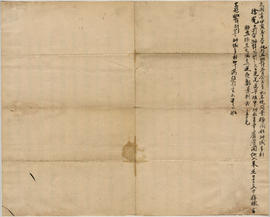
Labour contract for actor - Xu Guang (verso)
Labour contract for actor - Xu Guang (front side)
Plan of the Vancouver Exhibition grounds
A souvenir and correct map of the location of all the fair buildings of the Vancouver Exhibition
Map of Stanley Park, Vancouver, B.C.
Map of Stanley Park, Vancouver, B.C.
Map of Stanley Park, Vancouver, B.C.
Map of Stanley Park, Vancouver, B.C.
Valley of a Thousand Falls, Mount Robson Park, B.C.
Mount Robson, B.C. Highest Mountain in the Canadian Rockies
Junction of the Skeena and Bulkley Rivers, B.C.
Smoky River Falls, Mount Robson, B.C.
On the Skeena River, B.C.
On the Portland Canal, B.C.
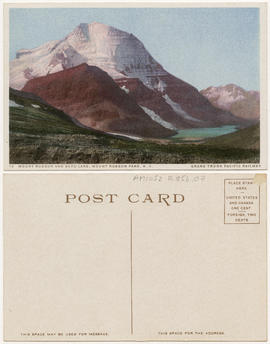
Mount Robson and Berg lake, Mount Robson Park, B.C.
Envelope for 10 postcards
Mount Fitzwilliam, Mount Robson Park, B.C.
Birthplace of Grand Fork River, Mount Robson Park, B.C.
Emperor Falls, Mount Robson B.C.
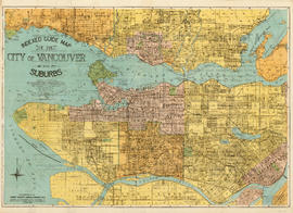
Plan of the City of Vancouver
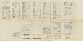
The Western Guide, index to map
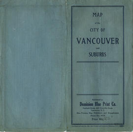
Map of the City of Vancouver and suburbs : map cover
Greater Vancouver
A few facts about the north Fraser River
Indexed guide map of the City of Vancouver and suburbs
Standard tourist's guide to Stanley Park : page 1
Standard tourist's guide to Stanley Park : Stanley Park, Vancouver, B.C., key plan