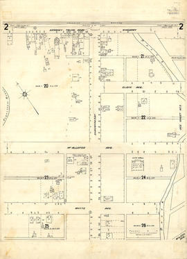
Print preview Close

Showing 281 results

Archival description
City of Vancouver Archives technical and cartographic drawing collection Part
Print preview View:

246 results with digital objects Show results with digital objects

Inset maps and indexes

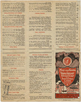
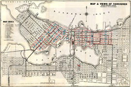
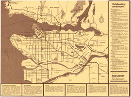
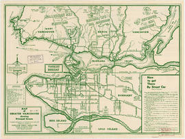
Part is the verso side of the pamphlet, which includes a street index, list of places of general interst and their location on on the main map, a list of B.C.E.R. routes, and an index of schools shown on the map. The page includes two inset maps, one of downtown Vancouver and one of Richmond, including a road index.

Insurance plan of Port Coquitlam : key plan and sheet 1

Part contains the key plan for the insurance plan of Port Coquitlam, an inset map of the area bounded by Shaughnessy Street, Central Avenue, and Rindall Avenue, and a section of the insurance plan covering Dewdney Trunk Road where it crosses the Coquitlam River. Map shows legal descriptions, street widths, building dimensions and types (dwelling, office, industrial, other commercial use), names of businesses, and other features of the built environment relevant to insurance claims.

Insurance plan of Port Coquitlam : sheet 2

Part contains a section of the insurance plan covering the area bounded by the Coquitlam River, an unnamed creek, Dewdney Trunk Road, and Whyte Avenue. Map shows legal descriptions, street widths, building dimensions and types (dwelling, office, industrial, other commercial use), names of businesses, and other features of the built environment relevant to insurance claims.

Insurance Plan of Port Coquitlam : sheet 3

Part contains a section of the insurance plan covering the area bounded by an unnamed creek, Kingsway Avenue, and Atkins Avenue. Map shows legal descriptions, street widths, building dimensions and types (dwelling, office, industrial, other commercial use), names of businesses, and other features of the built environment relevant to insurance claims.

Insurance Plan of Port Coquitlam : sheet 4

Part contains a section of the insurance plan covering the area bounded by Chester Street, Cambridge Street, Grant Avenue, and Suffolk Avenue. Map shows legal descriptions, street widths, building dimensions and types (dwelling, office, industrial, other commercial use), names of businesses, and other features of the built environment relevant to insurance claims.

Map and Guide to Vancouver Street Car and Interurban Lines

Part is the front side of an informational pamphlet published by the BC Electric Railway Co. regarding City streetcar routes and interurban lines, golf and country clubs, city trips, interurban trips, motor coach trips, stations, ferries and docks, bathing beaches, public parks, North Shore canyons and parks, athletic and amusement parks.

Map of Fraser Valley

Part consists of a map showing major roadways in the Lower Mainland and the Fraser Valley from Vancouver to Chilliwack, and lists of Vancouver businesses, schools, public buildings, hospitals, bathing beaches, fire halls, and golf and country clubs. Part includes text advertising the products and services of the Dominion Map and Blueprint Company.

Map of Lulu Island and Sea Island ; Municipality of Delta ; Municipality of Surrey ; Municipality of Langley ; Map of Maillardville

Part contains street maps of Lulu Island and Sea Island, Delta, Surrey, Langley, and Maillardville, tourist information about Vancouver, and text advertising the products and services of the Dominion Map and Blueprint Company.

Map of the municipalities of New Westminster City and District, British Columbia

Part contains a map of the Lower Mainland and Fraser Valley from the Gulf of Georgia in the west to Harrison Lake in the east. Map shows locations of churches, schools, canneries, sawmills, brickyards, tanneries, woolen mills and hatcheries; existing and proposed railways; and roadways.

Map of the municipalities of New Westminster, British Columbia

Part consists of the map component of a pamphlet. The map shows the location of churches, school, canaries, sawmills, backyards, tanneries, woolen mills, hatcheries, roads, and railways on a map which depicts the area of Greater Vancouver from the Gulf of Georgia east to Harrison Lake and south to the United States border.

Map of Vancouver, Burnaby, New Westminster, British Columbia : street index and advertisements

Part contains a street index for the main map of Vancouver on the other side of the sheet, advertisements for Bekins Moving and Storage and Allied Van Lines, and three maps showing the companies' service areas in the United States, Canada, and British Columbia and Alberta. An annotation reads: "Oppenheimer collection."

Results 101 to 150 of 281