- AM1594-: MAP 584
- Item
- [1973?]
Part of City of Vancouver Archives technical and cartographic drawing collection
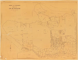
Item is a street map of the City of Vancouver showing streets, schools, hospitals, parks and golf courses. A street index is included. A dial would have been attached at the centre of the map, but the dial has since been removed.
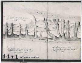
![Sketch of part of line of waggon [sic] road from "Boston Bar" to "Yale"](/uploads/r/null/6/8/5/685aeba6eb70cf489e3dc55456603ed30b0d42c00326cb69f8eb8fa758e030aa/714b3ee8-af5a-4786-85f4-230287a8d5fa-LEG1800_142.jpg)

![Sketch of part of proposed line of waggon [sic] road from "Boston Bar" to "Yale&qu...](/uploads/r/null/c/e/2/ce2401c4feac301ae2c09b558486e5d36c42075bdbdb34d93491fb38bf94199b/a0d055f2-d790-4fc6-b0aa-1572524f65c8-LEG1800_142.jpg)
![Postal Station [Granville and West Hastings streets]](/uploads/r/null/b/4/1/b4186985e2bb9ebae1b8cd849468ad83513d9584e040aa756a42bfb32e28455b/de507cc1-7f65-44cc-a9ea-a7b46caea5c5-1981-010_142.jpg)
![Stanley Park [Golden Jubilee]](/uploads/r/null/2/4/24135e2d726e60ffbc74f0d81c3a53d51a38fe9ea1e86ecda92708249adac23b/1b46df5d-6871-41b2-b1dd-91a0c1d5ad02-MAP624_142.jpg)


![Plate 11: Downtown [Homer Street - Georgia Street - Thurlow Street - Burnaby Street/Drake Street]](/uploads/r/null/5/b/d/5bdf92b6d2c774df0db66b41942f3eacb7f3ac265aeefeac99ba2fe6be2377b8/42419aa4-f47a-47ec-870b-3fdab1496d88-MAP342a_142.jpg)


![Plate 124 [B.C. Penitentiary grounds to Queens Avenue to Sixth Street to Fraser River]](/uploads/r/null/d/6/1/d6109bdd8c80b7d668876a803cd92924e7a854073c637f53db4b2c4f2f56e7dd/f8d97cae-19cc-470a-868c-534f137994b1-1972-472_142.jpg)
![Plate 123 [Sixth Street to Queens Avenue to eastern tips of Poplar and Lulu Islands to Fraser River]](/uploads/r/null/9/6/d/96d1122e04715f2f5792c19254f6b90991bd8c8f67f1c7becfcc31e30d3fbca4/a6cd188b-876a-455e-976e-285546a198db-1972-472_142.jpg)
![Plate 122 [Brunette River to Brunette Street to S.B. III Block 5 to Fraser River]](/uploads/r/null/1/b/5/1b59e8167ff1f1ff2d6e31874f106bae417d748922ed50d678f528ec9ec0e187/0abdbdc1-6755-45b1-aefc-0f6dd819227c-1972-472_142.jpg)
![Plate 121 [Keary Street to Sixth Avenue to Second Street to Park Row/Fraser River]](/uploads/r/null/e/0/b/e0b9110e611fca8e7037073a608b76e7d8623e29f738c47ba3234626357a78c4/da4cc06d-e15e-47b9-8187-683773fb2ef5-1972-472_142.jpg)
![Plate 120 [Second Street to Sixth Avenue to Twelfth Street to Queens Avenue]](/uploads/r/null/5/5/c/55c9677679407ee3ed1945edde4c9075d95bd4718a26b039ac09364740c4d69a/d6480416-ce8f-4c85-9e61-c26d7aab755f-1972-472_142.jpg)
![Plate 119 [Twelfth Street to Sixth Avenue to Twentieth Street/Lulu Island to Queens Avenue]](/uploads/r/null/7/c/5/7c5b58a5a6cc6d172d2c03c80829cda67864964df06d73df2acf92a075f3ac61/14e5f78e-0f29-4094-a1f1-0e18e3e413de-1972-472_142.jpg)
![Plate 118 [Brunette River to Tenth Avenue to Langley/School/Keary Streets to Brunette Street]](/uploads/r/null/1/2/c/12c40d6d14f873e070ca2b0a5bfe05f2d1b13bcaf1775c8dc357e7ca81a55dda/1f12f0be-27cc-46e2-a722-0a8c209f762c-1972-472_142.jpg)
![Plate 117 [Richmond/Sherbrooke/Langley Streets to Tenth Avenue to Second Street to Sixth Avenue]](/uploads/r/null/9/a/e/9ae713ff3ad4c6eb7965c92b08a6609a1355df01d8464e5dc0a4cd5eb347daa3/42ac18ba-9e2f-47a3-9c4d-62090da71521-1972-472_142.jpg)
![Plate 116 [Second Street to Tenth Avenue to Twelfth Street to Sixth Avenue]](/uploads/r/null/9/4/a/94a2eaaee6d845d8743ef8c81252057bc025656a77c773dd17e5aa37113b3116/fe7612b5-f7f4-4f6f-b985-a278440f8554-1972-472_142.jpg)
![Plate 115 [Twelfth Street to Tenth Avenue to Twentieth Street to Sixth Avenue]](/uploads/r/null/3/e/b/3eb1b1f2663b11b9151d3e22347f7b1fe922789a9a5866f3bf24b29d5b441606/74148ea4-ae2e-43f6-b969-bcdfff9ac71a-1972-472_142.jpg)

![Plate 5: West End [Richards Street - Hastings Street - Thurlow Street - Georgia Street]](/uploads/r/null/6/e/8/6e8029e15299600c6890f41cb1e769ea5f4c8a79c7923ef6e2075a19883197b7/ae297304-5960-4a77-930f-8a2926cc0ee0-MAP342a_142.jpg)


![City of Vancouver [park sites June/80]](/uploads/r/null/9/4/9484add7c4684ea3838e4d00ee8add3ecf85d78d5aa8fe2780cae273e59556a5/bd2464d8-2aa9-4501-aba6-8b3f7d130a42-MAP1032_142.jpg)


![Commercial map of Greater Vancouver and district [assessment districts]](/uploads/r/null/0/9/2/0928add1a06ab55bc236f8bebb87712b7e6ad4422db32cc3065efe7c9da96c04/b5b4129d-f9ba-49b9-a863-2ab6e954897e-MAP102_142.jpg)
![The Seechelt [Sechelt] Forest](/uploads/r/null/e/6/d/e6d1e8d1a7613c8e7ce050434f42ef80f8e00ca339edc6e23dc578f9a4154957/c9ad5fbf-94a8-4925-8b43-b0845d5bd699-MAP54_142.jpg)