
- AM1594-: MAP 872
- Item
- [197-?]
Part of City of Vancouver Archives technical and cartographic drawing collection
Item is a map which is a re-print of Arrowsmith's map of British North America.
Arrowsmith, John
1440 results with digital objects Show results with digital objects
Part of City of Vancouver Archives technical and cartographic drawing collection
Item is a map which is a re-print of Arrowsmith's map of British North America.
Arrowsmith, John

British possessions in North America
Part of City of Vancouver Archives technical and cartographic drawing collection
Item is a map showing British territories and borders with Russian territories, the United States, and Mexico. Includes White population totals for Hudson Bay territory, Upper Canada, Lower Canada, New Brunswick, Nova Scotia, Cape Breton Is., Prince Edward Is., and Newfoundland as well as white population for United States claimed territory, broken down by state.
Part of City of Vancouver Archives technical and cartographic drawing collection
File consists of a booklet of maps advertising the sale of lots in the British Properties development in West Vancouver, B.C. Maps show lot dimensions and purchase price (some lots already listed as sold).
Brochure regarding sales of provincial government property in Vancouver
Part of City of Vancouver Archives technical and cartographic drawing collection
Item is a brochure advertising the sale of land in Vancouver owned by the provincial government. One side of the unfolded brochure is promotional text and an index map showing the general location of the lands to be sold. The reverse of the sheet shows a portion of District Lot 192 and the lots available for sale.
![Bungalow for C. [Cline] Singleton, Vancouver, B.C.](/uploads/r/null/0/e/8/0e8f1fe401cffa704dd33be7ad6a0d055f7ec516ba1d63dd924193e18c708652/396919ff-1214-495c-861e-1b7aa2dada84-1987-017_142.jpg)
Bungalow for C. [Cline] Singleton, Vancouver, B.C.
Part of City of Vancouver Archives technical and cartographic drawing collection
Item is an architectural drawing which contains front and side elevations, section, floor plan and schedule of doors.
Part of City of Vancouver Archives technical and cartographic drawing collection
Map shows lot numbers, lot boundaries and major roads in the municipality of Burnaby.
Part of City of Vancouver Archives technical and cartographic drawing collection
Item is a map showing zoning in Burnaby according to the following zoning districts: commercial, light industrial, heavy industrial, residential and unzoned. The map also shows streets, railways and municipal boundaries.
Burnaby (B.C.). Town Planning Commission

Part of City of Vancouver Archives technical and cartographic drawing collection
Item is a sheet with three nautical charts. The main chart depicts Burrard Inlet from Atkinson Point [Point Atkinson] in the west to the "townsite of Port Moody" in the east. The inset charts depict Vancouver Harbour and the Second Narrows.
Part of City of Vancouver Archives technical and cartographic drawing collection
Item is a nautical chart depicting Burrard Inlet, including English Bay, Vancouver Harbour, False Creek, Second Narrows, the North Arm of Burrard Inlet and Port Moody. Soudings are given in fathoms.

Part of City of Vancouver Archives technical and cartographic drawing collection

Burrard Inlet - Dollarton sheet
Part of City of Vancouver Archives technical and cartographic drawing collection

Burrard Inlet - Port Moody sheet
Part of City of Vancouver Archives technical and cartographic drawing collection

Burrard Inlet - Second Narrows sheet
Part of City of Vancouver Archives technical and cartographic drawing collection

Burrard Inlet - triangulation control
Part of City of Vancouver Archives technical and cartographic drawing collection

Burrard Inlet - Vancouver sheet
Part of City of Vancouver Archives technical and cartographic drawing collection

Burrard Inlet : Vancouver sheet : British Columbia
Part of City of Vancouver Archives technical and cartographic drawing collection
Item is a map showing streets, roads, buildings, trails, railways, electric railways, bridges, swing bridges, foot bridges, churches, schools, post offices, wharves, piers, dikes, piling lighthouses, lightships, beacons, ranges, range lights, buoys, triangulation stations and geographical features in Burrard Inlet from Moodyville in the east to First Narrows in the west. A small index map shows this and other numbered sheets in relation to one another.

Bus routes, city of Vancouver, November 26th 1937
Part of City of Vancouver Archives technical and cartographic drawing collection
Bus routes, city of Vancouver, November 26th, 1937
Part of City of Vancouver Archives technical and cartographic drawing collection
Item is a hand-drawn map showing additions to bus routes, proposed additions to bus routes, dates of bus route additions and miles of bus route additions in Vancouver. A November 26, 1937 edition of "The Buzzer" containing information on bus routes and a reproduction of the hand-drawn map has been affixed to the verso.
Part of City of Vancouver Archives technical and cartographic drawing collection
Item is a sheet with maps of Canada, Newfoundland, and the United States; photographs of the Lieutenant Governors of each province, the Governor General and various Prime Ministers of Canada.
Canadian National Railways mountain region : Vancouver, B.C.
Part of City of Vancouver Archives technical and cartographic drawing collection
Item is a map showing major roads, highways, railways and industrial centres in the Lower Mainland (from Langley west). The map shows nine different railway lines and the Roberts Bank development, with land described based on four categories: First stage - causeway plus 50 acres; Federal government - ultimate development; Provincial government - reclaimed industrial land; and Provincial government - assembled land.
Canadian Pacific agencies around the world
Part of City of Vancouver Archives technical and cartographic drawing collection
Part is the inside cover for the brochure, which lists the locations of Canadian Pacific agencies.
![Canadian Pacific map of Vancouver [west half]](/uploads/r/null/f/a/fa49266d21715d75ce93883012d471657dd058b90843927ec82b44d2bb42b007/f12ea9a5-4914-4db8-bda9-312aa2e2ccef-MAP10_142.jpg)
Canadian Pacific map of Vancouver [west half]
Part of City of Vancouver Archives technical and cartographic drawing collection
Item is a portion of a map depicting lands granted to the Canadian Pacific Railway in Vancouver. The portion depicts the West End and northern Kitsilano.
Canadian Pacific Railway exploration maps
Part of City of Vancouver Archives technical and cartographic drawing collection
File consists of 7 maps out of a series of at least 16 maps that were created or collected and reproduced to accompany a report of the Chief Engineer of the Candian Pacific Railway in January 1897.
Canadian Pacific Railway Company

Part of City of Vancouver Archives technical and cartographic drawing collection
Map shows a survey conducted by the Canadian Pacific Railway of English Bay, Burrard Inlet and Coal Harbour, including a rough outline of area and lots. Note on map reads "Certified as a correct plan showing the land required for right of way Burrard Inlet B.C., February 22, 1886. H.J. Cambie, Engineer in Charge." Map is certified as correct and signed by various C.P.R. officials, including W.C. Van Horne.
Canadian Rockies showing main line of Canadian Pacific Railway
Part of City of Vancouver Archives technical and cartographic drawing collection

Cape Caution to Port Simpson including Hecate Strait and part of Queen Charlotte Islands
Part of City of Vancouver Archives technical and cartographic drawing collection
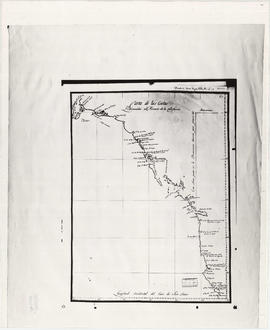
Carta de las costas reconocidas al Norueste de la California
Part of City of Vancouver Archives technical and cartographic drawing collection
Item is a reproduction of a map depicting the coast north of Spanish holdings in California.
Part of City of Vancouver Archives technical and cartographic drawing collection
Map shows the discoveries made in 1792 on the north-west coast of North American by examining Juan de Fuca Strait and the corresponding navigable channels, prepared for Dionisio Galiano and Captain Valdes, naval captains of the Royal (Spanish) Fleet in the year 1795.
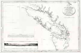
Carta esferica de los reconocimientos hechos en la costa No. America
Part of City of Vancouver Archives technical and cartographic drawing collection
Item is a reproduction of a map showing exploration and surveying in the region of Vancouver Island and adjacent mainland, south to modern Oregon.
Part of City of Vancouver Archives technical and cartographic drawing collection
Item is a reproduction of a map depicting the Spanish explorations of the north-west coast of North American in 1795, specifically depicting the northern end of Vancouver Island and the adjacent mainland. Illustrations are views of the entrance to Nootka Sound, and a view of "Cabo Frondoso" (Cape Cook?).
Part of City of Vancouver Archives technical and cartographic drawing collection
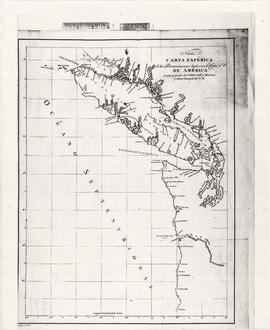
Map shows Juan de Fuca Strait, the San Juan Islands and the southern portion of Vancouver Island.
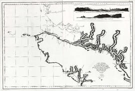
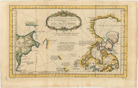
Carte de la cote N.O. de l' Amerique et de la cote N.E. de l'Asie
Part of City of Vancouver Archives technical and cartographic drawing collection
Item is a map showing the north west coast of America and the north east coast of Asia. Inset maps shows the entrance to Nootka Sound.

Part of City of Vancouver Archives technical and cartographic drawing collection
Map shows the Pacific Coast from Prince William Sound in the north though the Queen Charlotte Islands, Vancouver Island, Port S. Francisco and Sn. Diego to Sn. Domingo in the south.

Carte de la riviere de Cook dans la partie N.O. de l'Amerique
Part of City of Vancouver Archives technical and cartographic drawing collection
Item is a nautical chart showing "Cook's River" [Cook Inlet, Alaska]; the inset chart shows Oonalaska Island and gives soundings for "Samganoodha harbour" and the waters around the island.

Part of City of Vancouver Archives technical and cartographic drawing collection
Item is a map showing the Pacific Coast of British Columbia and Washington and Oregon states as surveyed by French explorer Jean-Francois de Galaup (Laperouse) in 1786, and the routes of his ships Astrolabe and Boussole. The map shows the Pacific coastline from Cap Rond (Tillamook Head) in Oregon at latitude 45 degrees and 40 minutes in the south to Baeie de Clonard (Beresford Bay, northwestern tip of Haida Gwaii) in British Columbia at latitude 54 degrees and 10 minutes in the north. Other major place names on the map include Nootka, Pointe Boisee, Baie St. Louis, Iles de Sartine, Mont Fleurieu, Cap Fleurieu, Cap Hector, Mont de la Touche, Baie de la Touche, and Baie de Clonard. Vancouver Island is shown as part of the mainland. Map includes latitudes and longtitudes as well as indication of elevations. Map is a plate from the "Atlas de Voyage de la Perouse".
Part of City of Vancouver Archives technical and cartographic drawing collection
Item is a map engraved by French cartographer M. Bellin showing eastern Asia and the northern part of North America, mainly Canada. Includes notes as to areas of the west coast of North America explored by the Russians in 1728 and 1741, the exploration of the entrance of the Strait of Juan de Fuca in 1592 and 1603, as well as exploration on the east coast of Asia. Map also includes latitudes and longitudes, some place names, major bodies of water and indicates mountainous regions. Printed on the bottom of the map is "Tome XV" and "No. 4."
Part of City of Vancouver Archives technical and cartographic drawing collection
File consists of an architectural plan for a two-bedroom bungalow drawn by Gore in December 1949 and a set of four drawings of a two-storey duplex on [West?] 16th Avenue completed in 1942.
Gore, Cecil N.

Champlain Heights : D.L. 334, group one, N.W.D.
Part of City of Vancouver Archives technical and cartographic drawing collection
Part is a map showing lot numbers, lot sizes, lot values and sidewalk crossings in the area from Rosemont Drive in the north to 63rd Avenue in the south and from Butler Street in the east to Kerr Street in the west.
![Chart of Nepigon [Nipigon] Bay. Lake Superior](/uploads/r/null/e/6/0/e6083525f33c7a6d0dd05f840915433768b0cfaed2c5b564153e3bfb5830f77e/8dd4e8d6-c36f-488f-a1bb-7aea7e098200-LEG1153_142.jpg)
Chart of Nepigon [Nipigon] Bay. Lake Superior
Part of City of Vancouver Archives technical and cartographic drawing collection
Item is a hydrographic chart depicting steamboat routes, roads, towns, rivers, soundings, and relief hachures on adjacent land areas.

Chart of part of the northwest coast of America explored by the Boussole & Astrolabe
Part of City of Vancouver Archives technical and cartographic drawing collection

Chart of the coast of British Columbia, north of latitude 51 degrees
Part of City of Vancouver Archives technical and cartographic drawing collection
Item is a hydrographic chart depicting the coastline adjacent to the Queen Charleoot Islands, showing rivers, islands, soundings, and physical features.

Chart of the coasts of America and Asia
Part of City of Vancouver Archives technical and cartographic drawing collection

Chart of the eastern Pacific Ocean
Part of City of Vancouver Archives technical and cartographic drawing collection

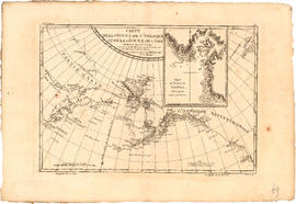
Chart of the n.w. coast of America and n.e. coast of Asia explored in the years 1778 and1779
Part of City of Vancouver Archives technical and cartographic drawing collection
Item is a re-printed version of a geographical map of the territories bordering on the northern Pacific.

Chart of the N.W. coast of America and the N.E. coast of Asia
Part of City of Vancouver Archives technical and cartographic drawing collection
Roberts, Lieut. Henry, R.N.
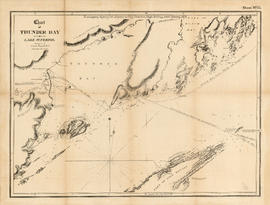
Chart of Thunder Bay. Lake Superior
Part of City of Vancouver Archives technical and cartographic drawing collection
Item is a hydrographic chart depicting steamboat routes, roads, towns, rivers, soundings, and relief hachures on adjacent land areas.

Part of City of Vancouver Archives technical and cartographic drawing collection
Item is a reproduction of a map depicting North America, Central America, South America, the southern portion of Greenland, northwestern Europe and northeastern Asia.

Part of City of Vancouver Archives technical and cartographic drawing collection
Item is a map depicting North America and South America and the boundaries between territories in 1776.
Charts of Captain George Vancouver
Part of City of Vancouver Archives technical and cartographic drawing collection
Item is an atlas consisting of sixteen map plates published in 1798, based on George Vancouver's surveys of North West America 1791-1795. All maps show depth soundings, routes of the HMS Discovery and HMS Chatham as well as the portions of coast surveyed.

Part of City of Vancouver Archives technical and cartographic drawing collection
Map is a topographical plan showing a proposed hydroelectric development in the Cheakamus River area, between Garibaldi Lake and Daisy Lake, and a profile along the tunnel and pipeline route. Included on the map are Daisy Lake, Garibaldi Lake, Cheakamus River, various creeks, including Parnassus Creek and Scott Creek, bluffs, and ponds. Also indicated on the map are the locations of a pipeline, tunnel and tunnel intake, the Daisy Lake Trail and other trails, a construction shaft, proposed dam, proposed Daisy Lake Reservoir, and the power station for the Garibaldi-Daisy Lake Development. The map was created to accompany E.A. Cleveland's "Report on a Preliminary Investigation of the Cheakamus River Power Possibilities made for the City of Vancouver."