Part is a section depicting the area bounded by Trutch Street to Fourth Avenue to Imperial Street to Sixteenth Avenue. The sheet has been extensively annotated, with colour coded areas to depict land use, status of lots as tax sale properties for sale, sewer and water lines, as well as other colour codes that are not noted on the legend at the front of the volume.
Part is a section depicting the area bounded by Imperial Street to Fourth Avenue to the University Endowment Lands to Sixteenth Avenue. The sheet has been extensively annotated, with colour coded areas to depict land use, status of lots as tax sale properties for sale, sewer and water lines, as well as other colour codes that are not noted on the legend at the front of the volume.
Part is a section depicting the area bounded by Trutch Street to English Bay to Imperial Street to Fifth Avenue. The sheet has been extensively annotated, with colour coded areas to depict land use, status of lots as tax sale properties for sale, sewer and water lines, as well as other colour codes that are not noted on the legend at the front of the volume.
Part is a section depicting the area bounded by Imperial Street to English Bay to the University Endowment Lands to Fifth Avenue. The sheet has been extensively annotated, with colour coded areas to depict land use, status of lots as tax sale properties for sale, sewer and water lines, as well as other colour codes that are not noted on the legend at the front of the volume.
Part is a section depicting the area bounded by Granville Street to Robson Street to Stanley Park to English Bay/False Creek. The sheet has been extensively annotated, with colour coded areas to depict land use, status of lots as tax sale properties for sale, sewer and water lines, as well as other colour codes that are not noted on the legend at the front of the volume.
Part is a section depicting the area bounded by Burrard Street to Coal Harbour to Stanley Park/Lost Lagoon to Robson Street. The sheet has been extensively annotated, with colour coded areas to depict land use, status of lots as tax sale properties for sale, sewer and water lines, as well as other colour codes that are not noted on the legend at the front of the volume.
Part is a section depicting: the area of Yaletown south of Robson Street and east of Granville Street to False Creek; and the area bounded by Ontario Street to False Creek to Ash Street to Sixth Avenue. The sheet has been extensively annotated, with colour coded areas to depict land use, status of lots as tax sale properties for sale, sewer and water lines, as well as other colour codes that are not noted on the legend at the front of the volume.
Part is a section depicting the area bounded by Columbia Street to Burrard Inlet to Burrard Street to Robson Street. The sheet has been extensively annotated, with colour coded areas to depict land use, status of lots as tax sale properties for sale, sewer and water lines, as well as other colour codes that are not noted on the legend at the front of the volume.
Part is a section depicting: the area of the West End south-west of Pacific Street between Bute Street and the CP railyards; Granville Island; and the area of Kitsilano north of Third Avenue and east of Maple Street. The sheet has been extensively annotated, with colour coded areas to depict land use, status of lots as tax sale properties for sale, sewer and water lines, as well as other colour codes that are not noted on the legend at the front of the volume.
Part is a section depicting the area bounded by Maple Street to English Bay to Trutch Street to Third Avenue. The sheet has been extensively annotated, with colour coded areas to depict land use, status of lots as tax sale properties for sale, sewer and water lines, as well as other colour codes that are not noted on the legend at the front of the volume.
Part is a section depicting the area bounded by Boundary Road to Burrard Inlet to Slocan Street to Triumph Street. The sheet has been extensively annotated, with colour coded areas to depict land use, status of lots as tax sale properties for sale, sewer and water lines, as well as other colour codes that are not noted on the legend at the front of the volume.
Part is one side of a sheet depicting rough sketches of survey data from surveys of the Green and Soo rivers, including profiles and cross-section profiles of various parts of the rivers.
Part is one side of a sheet depicting rough sketches of survey data from surveys of the Green and Soo rivers, including maps and cross-section profiles of various parts of the rivers.
Part is a base map showing zoning districts, streets, schools, parks, and golf courses, and includes a table of building lines as contained in Schedule "E" to By-law no. 3575.
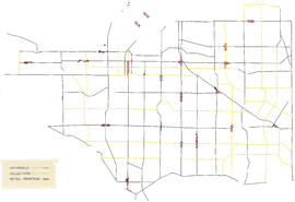
Part is a transparent overlay indicating arterial roads, collector roads, and retail frontage in Vancouver when used in conjunction with base map COV-S445-3-: MAP 714-: LEG1698.1.