
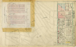
Point Grey section G supplementary information
- COV-S167---: LEG1153.456-: LEG1153.456.055
- Part
- [1947?]
Part of City of Vancouver fonds
Part is a sheet showing assessment and other information relevant to Point Grey section G.
137 results with digital objects Show results with digital objects
Point Grey section G supplementary information
Part of City of Vancouver fonds
Part is a sheet showing assessment and other information relevant to Point Grey section G.

Part of City of Vancouver fonds
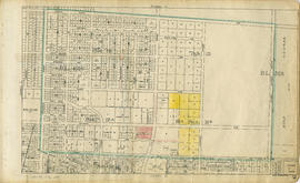
Part is a section depicting the area bounded by Granville Street to Sixteenth Avenue to Trafalgar Street to Twenty-eighth Avenue. The sheet has been extensively annotated, with colour coded areas to depict land use, status of lots as tax sale properties for sale, sewer and water lines, as well as other colour codes that are not noted on the legend at the front of the volume.

Point Grey section H supplementary information
Part of City of Vancouver fonds
Part is a sheet showing assessment and other information relevant to Point Grey section H.

Part of City of Vancouver fonds
Part is a section depicting the area bounded by Cambie Street to Sixteenth Avenue to Granville Street to Twenty-seventh Avenue. The sheet has been extensively annotated, with colour coded areas to depict land use, status of lots as tax sale properties for sale, sewer and water lines, as well as other colour codes that are not noted on the legend at the front of the volume.

Point Grey section J supplementary information
Part of City of Vancouver fonds
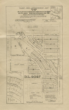
Part is a sheet with supplementary information in the form of a revised block plan for the are bounded by Crown Street to 27th Avenue to Camosun Street to 29th Avenue.
Part of City of Vancouver fonds
Part is a section depicting the area bounded by Wallace Street to Twenty-eighth Avenue to University Endowment Lands to Thirty-eighth Avenue. The sheet has been extensively annotated, with colour coded areas to depict land use, status of lots as tax sale properties for sale, sewer and water lines, as well as other colour codes that are not noted on the legend at the front of the volume. The left-hand side of the sheet has had an overlay applied which depicts revisions to the blocks bounded by Crown Street to 29th Avenue to Camosun Street to 31st Avenue.

Point Grey section K supplementary information
Part of City of Vancouver fonds
Part is a sheet showing assessment and other information relevant to Point Grey section K.

Part of City of Vancouver fonds
Part is a section depicting the area bounded by Trafalgar Street to Twenty-seventh Avenue to Wallace Street to Thirty-eighth Avenue. The sheet has been extensively annotated, with colour coded areas to depict land use, status of lots as tax sale properties for sale, sewer and water lines, as well as other colour codes that are not noted on the legend at the front of the volume.

Point Grey section L supplementary information
Part of City of Vancouver fonds
Part is a sheet showing assessment and other information relevant to Point Grey section L.

Part of City of Vancouver fonds
Part is a section depicting the area bounded by Granville Street to Nanton Avenue to Trafalgar Street to Thirty-eighth Avenue. The sheet has been extensively annotated, with colour coded areas to depict land use, status of lots as tax sale properties for sale, sewer and water lines, as well as other colour codes that are not noted on the legend at the front of the volume.

Part of City of Vancouver fonds
Part is a section depicting the area bounded by Queen Elizabeth Park to Twenty-seventh Avenue to Granville Street to Thirty-eighth Avenue. The sheet has been extensively annotated, with colour coded areas to depict land use, status of lots as tax sale properties for sale, sewer and water lines, as well as other colour codes that are not noted on the legend at the front of the volume.
Point Grey section N supplementary information
Part of City of Vancouver fonds
Part is a sheet showing assessment and other information relevant to Point Grey section N.

Part of City of Vancouver fonds
Part is a section depicting the area bounded by Wallace Street to Thirty-eighth Avenue to Musqueam Indian Reserve to Forty-ninth Avenue. The sheet has been extensively annotated, with colour coded areas to depict land use, status of lots as tax sale properties for sale, sewer and water lines, as well as other colour codes that are not noted on the legend at the front of the volume.

Point Grey section O supplementary information
Part of City of Vancouver fonds
Part is a sheet showing assessment and other information relevant to Point Grey section O.

Part of City of Vancouver fonds
Part is a section depicting the area bounded by Trafalgar Street to Thirty-eighth Avenue to Wallace Street to Forty-ninth Avenue. The sheet has been extensively annotated, with colour coded areas to depict land use, status of lots as tax sale properties for sale, sewer and water lines, as well as other colour codes that are not noted on the legend at the front of the volume.
Point Grey section P supplementary information
Part of City of Vancouver fonds
Part is a sheet showing assessment and other information relevant to Point Grey section P.

Part of City of Vancouver fonds
Part is a section depicting the area bounded by Granville Street to Thirty-seventh Avenue to Trafalgar Street to Forty-ninth Avenue. The sheet has been extensively annotated, with colour coded areas to depict land use, status of lots as tax sale properties for sale, sewer and water lines, as well as other colour codes that are not noted on the legend at the front of the volume.

Point Grey section Q supplementary information
Part of City of Vancouver fonds
Part is a sheet showing assessment and other information relevant to Point Grey section Q.

Part of City of Vancouver fonds
Part is a section depicting the area bounded by Cambie Street to Thirty-eighth Avenue to Granville Street to Forty-ninth Avenue. The sheet has been extensively annotated, with colour coded areas to depict land use, status of lots as tax sale properties for sale, sewer and water lines, as well as other colour codes that are not noted on the legend at the front of the volume.

Point Grey section S supplementary information
Part of City of Vancouver fonds
Part is a sheet showing assessment and other information relevant to Point Grey section S.

Part of City of Vancouver fonds
Part is a section depicting the area bounded by Marine Crescent to Forty-ninth Avenue to Wallace Street to the Fraser River. The sheet has been extensively annotated, with colour coded areas to depict land use, status of lots as tax sale properties for sale, sewer and water lines, as well as other colour codes that are not noted on the legend at the front of the volume.

Point Grey section T supplementary information
Part of City of Vancouver fonds
Part is a sheet showing assessment and other information relevant to Point Grey section T. The sheet also includes an added overlay depicting revised block plans for the area bounded by Arbutus Street to 53rd Avenue to Beechwood Street to 57th Avenue.

Part of City of Vancouver fonds
Part is a section depicting the area bounded by Granville Street to Forty-ninth Avenue to Marine Crescent to Sixty-first Avenue. The sheet has been extensively annotated, with colour coded areas to depict land use, status of lots as tax sale properties for sale, sewer and water lines, as well as other colour codes that are not noted on the legend at the front of the volume.

Point Grey section U supplementary information
Part of City of Vancouver fonds
Part is a sheet showing assessment and other information relevant to Point Grey section U. The sheet also includes an added overlay depicting revised block plans for the eastern half of the block bounded by Oak Street to 57th Avenue to Hudson Street to Fifty-eighth Avenue (Lot 10, Block 17A, D.L. 526).
Part of City of Vancouver fonds
Part is a section depicting the area bounded by Cambie Street to Forty-ninth Avenue to Granville Street to Sixtieth Avenue. The sheet has been extensively annotated, with colour coded areas to depict land use, status of lots as tax sale properties for sale, sewer and water lines, as well as other colour codes that are not noted on the legend at the front of the volume.

Point Grey section W supplementary information
Part of City of Vancouver fonds
Part is a sheet showing assessment and other information relevant to Point Grey section W. The sheet also includes an added overlay depicting revised block and street plan for the blocks bounded by West Boulevard to 66th Avenue to Angus Drive to Sixty-eighth Avenue (Block 17, D.L. 317).

Part of City of Vancouver fonds
Part is a section depicting the area bounded by Granville Street to Sixtieth Avenue to the east boundary of D.L. 315 to the Fraser River/Seventy-first Avenue. The sheet has been extensively annotated, with colour coded areas to depict land use, status of lots as tax sale properties for sale, sewer and water lines, as well as other colour codes that are not noted on the legend at the front of the volume.

Point Grey section X supplementary information
Part of City of Vancouver fonds
Part is a sheet showing assessment and other information relevant to Point Grey section X.

Point Grey section X supplementary plans
Part of City of Vancouver fonds
Part is a sheet with supplementary information in the form of a two revised block plans: one for the area bounded by Ash Street to 59th Avenue to Heather Street to 66th Avenue; and the other the bock to the west side of Laurel Street between 64th Avenue and 67th Avenue.

Part of City of Vancouver fonds
Part is a section depicting the area bounded by Ash Street to Fifty-ninth Avenue to Granville Street to Seventy-first Avenue. The sheet has been extensively annotated, with colour coded areas to depict land use, status of lots as tax sale properties for sale, sewer and water lines, as well as other colour codes that are not noted on the legend at the front of the volume.
Point Grey section Z supplementary information
Part of City of Vancouver fonds
Part is a sheet showing assessment and other information relevant to Point Grey section Z.

Part of City of Vancouver fonds
Part is a sheet with two partial sections: one depicting the area bounded by Heather Street to Seventy-second Avenue to Granville Street to the Fraser River; the second depicting the area bounded by Granville Street to Suth-west Marine Drive to Angus Drive to the Fraser River. The maps have been extensively annotated, with colour coded areas to depict land use, status of lots as tax sale properties for sale, sewer and water lines, as well as other colour codes that are not noted on the legend at the front of the volume.
Part of City of Vancouver fonds
Part of City of Vancouver fonds

Part of City of Vancouver fonds
Item shows Point Grey harbour facilities and industrial lands, the Jericho naval reserve and golf links through a combination of a map and illustrations. A smaller key plan shows the location of the Vancouver Terminals Company's harbour properties in relation to the rest of Point Grey and Vancouver.

Part of City of Vancouver fonds
Item is a map showing the railway line from New Westminster to Point Grey. Railway data appears to have been added to a base map showing topographic contour lines, shorelines, low tide marks, natural divides, and municipal boundaries.

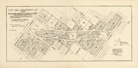
Sewerage system : plan of Point Grey Municipality
Part of City of Vancouver fonds
Item is a map annotated to show the sewer system in Point Grey. Base map was created by the Vancouver Map and Blue Print Co. and shows streets, railways, and district lot and block numbers.
Plan of Sewerage System Point Grey Municipality
Part of City of Vancouver fonds
The map shows the Point Grey Area and its district lot boundaries, street car lines, and postal block numbers. The map displays streets, parks, railways, and schools. Additionally, there are annotations red which mark the sewerage and drainage for the area. The size of the pipes is also incrementally listed.
The Northernmost point on the map is the English Bay and the Southernmost point is the North Arm of the Fraser River. The Easternmost is Ontario St. and Westernmost road on the map is Marine Drive beside UBC.
W.C. Grey was the engineer that produced the map.