
- AM1519-: PAM Und. 500-: LEG1319.385
- Part
- [ca. 1943]

Sectional map and street directory of Vancouver, British Columbia : Vancouver street car routes

Sectional map and street directory of Vancouver, British Columbia : list of busses


Sectional map and street directory of Vancouver, British Columbia : Blue Ribbon advertisement

Part shows a map of the City of Vancouver extending from Boundary Road to Burrard Inlet to Alma Street to King Edward. Lot numbers and street names are shown, along with ward lines, district lot lines street railway lines and railroad lines represented by a legend in the bottom left corner.

How to see Vancouver, Canada : side 1
Part is one side of pamphlet entitled "How to see Vancouver, Canada." Part contains suggestions for activities, trips and locations to visit, as well as two inset maps: "Street Map of Vancouver's Business District" and "Roads in Vancouver and District."

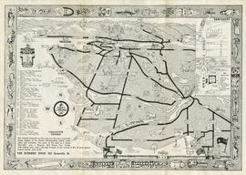
Standard tourist's guide to Stanley Park : Stanley Park, Vancouver, B.C., key plan
Part is a map showing points of interest in Stanley Park, including car lines, roads and car routes, buildings, beaches, and trails.

Indexed map of Greater Vancouver : side 2
Part contains a map of the Greater Vancouver area from Gulf of Georgia to Frederick Road to Craig Street to Lulu Island, accompanied by an index of street names.

University Hill : the residential section of Greater Vancouver : side 1
Part contains a map showing properties, with lot numbers and prices, for sale from Westbrook Crescent to Chancellor Boulevard to Acadia Road to Toronto Road. A legend showing the zoning for each property accompanies the map.

Westmount Park : the subdivision superb : side 2
Part contains information about purchasing lots in Westmount Park and is accompanied by two inset maps. One map shows the lots for sale from Blanca Street to Belmont Drive to Tolmie Street to Second Avenue, their numbers and a price list, the other map shows where Westmount Park is situated in Vancouver.

Sectional map and street directory of Vancouver, British Columbia : map of Stanley Park

Westmount Park : the subdivision superb : side 1
Part is the cover page showing an illustration of the area of Westmount Park.

Sectional map and street directory of Vancouver, British Columbia : key to university buildings


Sylvia Court : Gilford at Beach, Vancouver, B. C. : side 1
Part shows an illustration of Sylvia Court and an illustration showing the route to Sylvia Court without driving through the city.

Sectional map and street directory of Vancouver : key plan
Part contains key plan for sectional map. Key plan extends from the Fraser River to Queens Road to the University of British Columbia to Lulu Island.
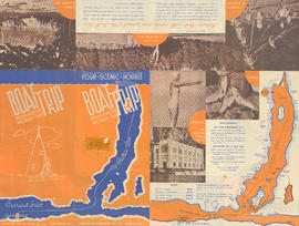
Boat trip up Indian Arm : Indian River Pk, Wigwam Inn : side 1
Part contains information about Wigwam Inn rates, boat schedules, tourist attractions such as Belcarra Park and the location of the Wigwam Inn shown by an illustrated map.

Wigwam Inn : hunting, fishing, boating and mountaineering : side 1
Part contains title page and illustrations of the Wigwam Inn, a map showing the location of the Wigwam Inn, text advertising the Inn and photographs showing the interior of the Inn and a nearby lagoon.


Sectional map and street directory of Vancouver : map of West Vancouver
Scenery Shop pamphlet : side 2
Part contains a map showing Vancouver, Surrey, Coquitlam, Burnaby, North Vancouver, Sea Island and Lulu Island illustrated with people, animals, vehicles and buildings. The map shows few street names, tourist destinations, and the location of the Scenery Shop in an inset map. A border with First Nations symbols surrounds the map and is accompanied by a legend of symbols.

Sectional map and street directory of Vancouver : map of Stanley Park
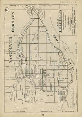
Sectional map and street directory of Vancouver : map of Lulu Island

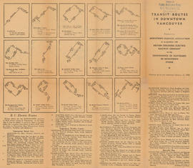
Transit routes in downtown Vancouver : side 1
Part contains illustrations of the downtown Vancouver portions of the B.C. Electric transit routes and text descriptions of all B.C. Electric transit routes in Vancouver, New Westminster, North Vancouver, Richmond, and Burnaby effective up to and including February 15, 1950.

Shortest - fastest : fair to fair : United Air Lines : side 2
Part contains a map showing United Air Lines destinations accompanied by text with information about fair to fair service.

This time . . . go by bus : Pacific Stage Lines : side 2
Part contains text addressing Pacific Stage Lines schedule, accommodations, route, and bus terminal information. A map accompanies text showing bus routes from Vancouver through the United States and up to Halifax.

City map and points of interest of Vancouver, British Columbia : side 2
Part contains a map showing principal streets located in Vancouver, North Vancouver, West Vancouver, Burnaby, Lulu Island, and Sea Island. Accompanying map is a list of directions to popular destinations.

Transit routes in downtown Vancouver : side 2
Part contains a continuation of text descriptions of transit routes from side 1. Part also contains a map showing B.C. Electric transit routing in downtown Vancouver. Map includes street names and a legend of routes and stops.

Welcome to Vancouver, Canada : side 2
Part contains a map of Vancouver, North Vancouver, West Vancouver, Burnaby, Lulu Island and Sea Island. Map shows principal street names, parks, beaches, golf courses and fishing spots.

Victoria and Vancouver Island 1954 Princess routes for passengers and motor cars : side 2
Part contains textual information about rates and fares, ferry service schedules, accommodations. Text is illustrated with photographs of ferry interiors, hotels and an inset map showing the ferry routes. Map extends from the Pacific Ocean to Olympia, Washington to Campbell River to Everett, Washington.

Visitor's map of Vancouver : side 2
Part contains a visitors map of Vancouver extending from the Straight of Georgia to Grouse Mountain to Surrey to Westminster Highway. Map shows bodies of water, principal street names, beaches, and some tourist destinations. Map is illustrated with cartoons.

Visitor's map of Vancouver : side 1
Part contains two inset maps, one map of Stanley Park showing trails, bridle paths and traffic direction, and one map of Downtown Vancouver showing 24 points of interest and street names. Part also contains text with tourist information including traffic rules, and locations of popular destinations.
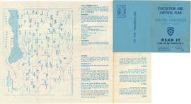
Civil Defence evacuation and survival plan for Greater Vancouver target area : side 1
Part contains the front and back covers of the pamphlet and a map showing evacuation assembly points at docks and school playgrounds for people without cars. Part also contains text with evacuation instructions. Map is courtesy of Vancouver School Board, text and additions made to map by Vancouver Civil Defence.
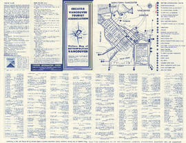
Visitors' map of metropolitan Vancouver : side 1
Part contains one inset map of Downtown Vancouver showing 26 points of interest and street names. Part also contains text with tourist information including traffic rules, and a list of businesses and services.

Visitors' map of metropolitan Vancouver : side 2
Part contains a visitors map of Vancouver. Map extends from the Straight of Georgia to Grouse Mountain to North Road to Westminster Highway. Map shows bodies of water, principal street names, beaches, and some tourist destinations. Map is illustrated with cartoons.