
Vancouver public aquarium, Stanley park : side 1
- AM1519-: PAM 1963-148-: LEG1319.155
- Part
- 1963
Part contains cover of pamphlet with illustrations of fish, and a map showing general location of the Vancouver Aquarium with directions.
220 results with digital objects Show results with digital objects
Vancouver public aquarium, Stanley park : side 1
Part contains cover of pamphlet with illustrations of fish, and a map showing general location of the Vancouver Aquarium with directions.

Vancouver public aquarium, Stanley park : side 2
Part contains textual information about the Vancouver Public Aquarium, illustrated with photographs showing species on display at the aquarium.

Automobile road map of Vancouver Canada : side 1
Part contains textual information including points of interest, Canadian customs regulations, ferry timetables and rates. Part also contains two inset maps. A map of the Okanagan Circuit is in the top left corner, showing town names and a distance table with distances of towns from Vancouver in miles. A map showing ferry routes in the Gulf of Georgia is located in the middle of part.

Automobile road map of Vancouver Canada : side 2
Part contains a map showing major automobile roads extending from English Bay to The Lions to Clayburn to Blaine, Washington. Roads are shown in red. An inset map showing a continuation from Mission and Huntingdon to Harrison Hot Springs is located in top right corner of part.

Highways of Greater Vancouver British Columbia and the Fraser Valley : side 1
Part contains a map showing main thoroughfares and other streets in Downtown Vancouver. Part also includes tourist information on boat and ferry connections, motor drives, boat trips, fishing, hunting, recreation, and mileages from Vancouver to other destinations.

Highways of Greater Vancouver British Columbia and the Fraser Valley : side 2
Part contains a road map of the Fraser Valley extending from the Gulf of Georgia to Pitt Lake to Mount Cheam to Blaine, Washington. Legend on map shows main arterial roads, secondary roads, other roads, hiking trails, ferries and railways.

Map of downtown Vancouver, B.C. and sightseeing schedule : side 1
Part contains cover of pamphlet and textual information about Gray Lines sightseeing tours, rates, and schedules.

Map of downtown Vancouver, B.C. and sightseeing schedule : side 2
Part contains an illustrated map showing street names and tourist destinations in Downtown Vancouver and Stanley Park.

Welcome to Vancouver Canada : side 1
Part contains advertisements, tourist information, trip recommendations and is illustrated with photographs of popular Vancouver destinations.

Welcome to Vancouver Canada : side 2
Part contains a map of Vancouver, North Vancouver, West Vancouver, Burnaby, Lulu Island and Sea Island. Map shows principal street names, parks, beaches, golf courses and fishing spots.

Tourists' map of Greater Vancouver : cover
Part contains the front and back covers of the pamphlet, a map of Downtown Vancouver, a map of the downtown section of New Westminster, and information for tourists, including interesting facts about Vancouver. Maps show principal street names and some building names.

Tourists' map of Greater Vancouver : inside cover
Part consists of the inside cover of pamphlet containing information about David Spencer Limited.

Part consists of a map of Greater Vancouver. Map extends from Howe Sound to Dome Mountain to Pitt River to Lulu Island. Map shows principal street names, golf and country clubs, bodies of water and city limits. Part contains textual information about parking regulations for the David Spencer store.

Map of Vancouver, British Columbia : side 1
Part contains advertisements for Bekin Moving and Storage Co. illustrated by photos of the Bekin Storage building and moving truck. Part also contains a section called "Salient facts about Vancouver."

Map of Vancouver, British Columbia : side 2
Part contains a map of the Greater Vancouver area from Gulf of Georgia to Queen's Avenue to Grosvenor Avenue to No. 20 Road, accompanied by an index of street names.

Sectional map and street directory of Vancouver, British Columbia : cover


Sectional map and street directory of Vancouver, British Columbia : Iris Steam Baths advertisement

Sectional map and street directory of Vancouver, British Columbia : E. Anderson furs advertisement

Sectional map and street directory of Vancouver, British Columbia : introduction to map

Sectional map and street directory of Vancouver, British Columbia : street directory

Sectional map and street directory of Vancouver, British Columbia : street directory

Sectional map and street directory of Vancouver, British Columbia : street directory

Sectional map and street directory of Vancouver, British Columbia : street directory

Sectional map and street directory of Vancouver, British Columbia : street directory

Sectional map and street directory of Vancouver, British Columbia : street directory

Sectional map and street directory of Vancouver, British Columbia : street directory

Sectional map and street directory of Vancouver, British Columbia : street directory

Sectional map and street directory of Vancouver, British Columbia : street directory

Sectional map and street directory of Vancouver, British Columbia : map of Stanley Park

Sectional map and street directory of Vancouver, British Columbia : key plan


Sectional map and street directory of Vancouver, British Columbia : map of West Vancouver
Part is a map of West Vancouver that extends from Whytecliff Point to Eagle Lake to Capilano Road to Burrard Inlet.

Part contains two maps. The map showing North Vancouver and district extends from the Capilano River to Coleman Road to Taylor Road to Bridge Street]. The map showing Lulu Island and Sea Island extends from No. 1 Road to Mitchell Road to Boundary Road to the Fraser River.

Part contains two maps. The map of New Westminster and part of Burnaby extends from Royal Oak Avenue to Burnaby Lake to Brunette Road to Salter Street.

Sectional map and street directory of Vancouver, British Columbia : map of Greater Vancouver
Part contains a map of Greater Vancouver showing street railways, bus lines, and motor roads. Map also contains a list of parks and a key to their numbered locations on the map. Map extends from the University of British Columbia to Stanley Park to Boundary Road to Sea Island.
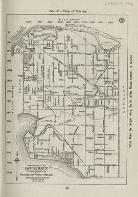
Sectional map and street directory of Vancouver, British Columbia : municipality of Surrey
Part contains two maps. The map of Maillardville extends from Columbia Street to Smith Road to School House Road to Brunette River. The map showing the Municipality of Surrey extends from Scott Road to the Fraser River to Kells Road to Beach Road.

Sectional map and street directory of Vancouver, British Columbia : Eden Café advertisement


Sectional map and street directory of Vancouver, British Columbia : Dixie Chicken Inn advertisement

Sectional map and street directory of Vancouver, British Columbia : Eddie R. Deem advertisement

Sectional map and street directory of Vancouver, British Columbia : Vancouver street car routes