Redevelopment plan for Jericho Department of National Defence lands
City of Vancouver
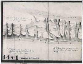
Sketch of part of line of waggon [sic] road from "Boston Bar" to "Yale"
Sketch of part of line of road along right bank of "Fraser River" from "Boston Bar" to "Yale"
Sketch of part of proposed line of waggon [sic] road from "Boston Bar" to "Yale" on left bank of "Fraser River"
Unidentified portion of Fraser River shoreline
A new map of Vancouver
A new map of Vancouver
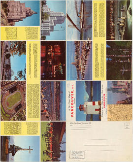
Vancouver, British Columbia, Canada
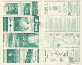
Where to go, what to do, how to see Vancouver
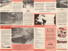
Vancouver harbour
The Port of Vancouver, British Columbia
Road maps
Let's go see! Inside Vancouver
Points of interest and directions
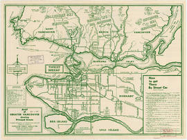
Map of Greater Vancouver showing principal streets
Postal Station [Granville and West Hastings streets]
Stanley Park [Golden Jubilee]
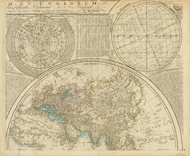
Johnson's North America
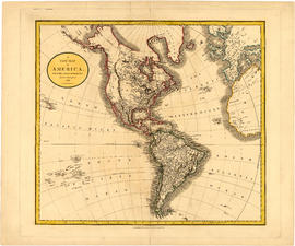
A new map of America, from the latest authorities
Map of New Westminster District, B.C.
Carte de la parte de la cote nord-ouest de l'Amerique : recconnue pendant les etes de 1792, 1793 and 1794, depuis 29D 54' de Latitude Nord et 244D 33' de Longitude Orientale, jusqu'au Cap Douglas par 58D 52' de Latitude et 207D 20' de Longitude, par le Ca
The Estate of Joseph Martin, K.C., MP
Plate 11: Downtown [Homer Street - Georgia Street - Thurlow Street - Burnaby Street/Drake Street]
City of Vancouver : east half
Plate 128 Queensborough - north-east
Plate 127 Queensborough - north-west
Plate 126 Queensborough - south-east
Plate 125 Queensborough - south-west
Plate 124 [B.C. Penitentiary grounds to Queens Avenue to Sixth Street to Fraser River]
Plate 123 [Sixth Street to Queens Avenue to eastern tips of Poplar and Lulu Islands to Fraser River]
Plate 122 [Brunette River to Brunette Street to S.B. III Block 5 to Fraser River]
Plate 121 [Keary Street to Sixth Avenue to Second Street to Park Row/Fraser River]
Plate 120 [Second Street to Sixth Avenue to Twelfth Street to Queens Avenue]
Plate 119 [Twelfth Street to Sixth Avenue to Twentieth Street/Lulu Island to Queens Avenue]
Plate 118 [Brunette River to Tenth Avenue to Langley/School/Keary Streets to Brunette Street]
Plate 117 [Richmond/Sherbrooke/Langley Streets to Tenth Avenue to Second Street to Sixth Avenue]
Plate 116 [Second Street to Tenth Avenue to Twelfth Street to Sixth Avenue]
Plate 115 [Twelfth Street to Tenth Avenue to Twentieth Street to Sixth Avenue]
Index to Streets and Index to Registered Plans
Plate 5: West End [Richards Street - Hastings Street - Thurlow Street - Georgia Street]
B.C. Electric plan showing bus stops in Vancouver
City of Vancouver
A preliminary proposal for development of Jericho Park


![Sketch of part of line of waggon [sic] road from "Boston Bar" to "Yale"](/uploads/r/null/6/8/5/685aeba6eb70cf489e3dc55456603ed30b0d42c00326cb69f8eb8fa758e030aa/714b3ee8-af5a-4786-85f4-230287a8d5fa-LEG1800_142.jpg)

![Sketch of part of proposed line of waggon [sic] road from "Boston Bar" to "Yale&qu...](/uploads/r/null/c/e/2/ce2401c4feac301ae2c09b558486e5d36c42075bdbdb34d93491fb38bf94199b/a0d055f2-d790-4fc6-b0aa-1572524f65c8-LEG1800_142.jpg)


![Postal Station [Granville and West Hastings streets]](/uploads/r/null/b/4/1/b4186985e2bb9ebae1b8cd849468ad83513d9584e040aa756a42bfb32e28455b/de507cc1-7f65-44cc-a9ea-a7b46caea5c5-1981-010_142.jpg)
![Stanley Park [Golden Jubilee]](/uploads/r/null/2/4/24135e2d726e60ffbc74f0d81c3a53d51a38fe9ea1e86ecda92708249adac23b/1b46df5d-6871-41b2-b1dd-91a0c1d5ad02-MAP624_142.jpg)


![Plate 11: Downtown [Homer Street - Georgia Street - Thurlow Street - Burnaby Street/Drake Street]](/uploads/r/null/5/b/d/5bdf92b6d2c774df0db66b41942f3eacb7f3ac265aeefeac99ba2fe6be2377b8/42419aa4-f47a-47ec-870b-3fdab1496d88-MAP342a_142.jpg)


![Plate 124 [B.C. Penitentiary grounds to Queens Avenue to Sixth Street to Fraser River]](/uploads/r/null/d/6/1/d6109bdd8c80b7d668876a803cd92924e7a854073c637f53db4b2c4f2f56e7dd/f8d97cae-19cc-470a-868c-534f137994b1-1972-472_142.jpg)
![Plate 123 [Sixth Street to Queens Avenue to eastern tips of Poplar and Lulu Islands to Fraser River]](/uploads/r/null/9/6/d/96d1122e04715f2f5792c19254f6b90991bd8c8f67f1c7becfcc31e30d3fbca4/a6cd188b-876a-455e-976e-285546a198db-1972-472_142.jpg)
![Plate 122 [Brunette River to Brunette Street to S.B. III Block 5 to Fraser River]](/uploads/r/null/1/b/5/1b59e8167ff1f1ff2d6e31874f106bae417d748922ed50d678f528ec9ec0e187/0abdbdc1-6755-45b1-aefc-0f6dd819227c-1972-472_142.jpg)
![Plate 121 [Keary Street to Sixth Avenue to Second Street to Park Row/Fraser River]](/uploads/r/null/e/0/b/e0b9110e611fca8e7037073a608b76e7d8623e29f738c47ba3234626357a78c4/da4cc06d-e15e-47b9-8187-683773fb2ef5-1972-472_142.jpg)
![Plate 120 [Second Street to Sixth Avenue to Twelfth Street to Queens Avenue]](/uploads/r/null/5/5/c/55c9677679407ee3ed1945edde4c9075d95bd4718a26b039ac09364740c4d69a/d6480416-ce8f-4c85-9e61-c26d7aab755f-1972-472_142.jpg)
![Plate 119 [Twelfth Street to Sixth Avenue to Twentieth Street/Lulu Island to Queens Avenue]](/uploads/r/null/7/c/5/7c5b58a5a6cc6d172d2c03c80829cda67864964df06d73df2acf92a075f3ac61/14e5f78e-0f29-4094-a1f1-0e18e3e413de-1972-472_142.jpg)
![Plate 118 [Brunette River to Tenth Avenue to Langley/School/Keary Streets to Brunette Street]](/uploads/r/null/1/2/c/12c40d6d14f873e070ca2b0a5bfe05f2d1b13bcaf1775c8dc357e7ca81a55dda/1f12f0be-27cc-46e2-a722-0a8c209f762c-1972-472_142.jpg)
![Plate 117 [Richmond/Sherbrooke/Langley Streets to Tenth Avenue to Second Street to Sixth Avenue]](/uploads/r/null/9/a/e/9ae713ff3ad4c6eb7965c92b08a6609a1355df01d8464e5dc0a4cd5eb347daa3/42ac18ba-9e2f-47a3-9c4d-62090da71521-1972-472_142.jpg)
![Plate 116 [Second Street to Tenth Avenue to Twelfth Street to Sixth Avenue]](/uploads/r/null/9/4/a/94a2eaaee6d845d8743ef8c81252057bc025656a77c773dd17e5aa37113b3116/fe7612b5-f7f4-4f6f-b985-a278440f8554-1972-472_142.jpg)
![Plate 115 [Twelfth Street to Tenth Avenue to Twentieth Street to Sixth Avenue]](/uploads/r/null/3/e/b/3eb1b1f2663b11b9151d3e22347f7b1fe922789a9a5866f3bf24b29d5b441606/74148ea4-ae2e-43f6-b969-bcdfff9ac71a-1972-472_142.jpg)

![Plate 5: West End [Richards Street - Hastings Street - Thurlow Street - Georgia Street]](/uploads/r/null/6/e/8/6e8029e15299600c6890f41cb1e769ea5f4c8a79c7923ef6e2075a19883197b7/ae297304-5960-4a77-930f-8a2926cc0ee0-MAP342a_142.jpg)


