
- AM1594-: MAP 676-: LEG1153.124
- Part
- [1911?]
Part of City of Vancouver Archives technical and cartographic drawing collection
246 results with digital objects Show results with digital objects
Part of City of Vancouver Archives technical and cartographic drawing collection

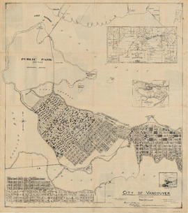
Map of Vancouver, B.C. including Hastings Townsite and D.L. 301
Part of City of Vancouver Archives technical and cartographic drawing collection
City of Vancouver. Canadian Pacific town site
Part of City of Vancouver Archives technical and cartographic drawing collection
Part is a map sheet with one principal map, three inset maps and one illustration. The main map is a copy of a L.A. Hamilton map of downtown Vancouver and the land surrounding False Creek. Textual information is provided about the history and layout of Stanley Park. Inset maps show the Canadian Pacific mail steamships lines around the world and an index plan of Vancouver, B.C.

Vancouver, B.C., Pacific terminus of the C.P.R.
Part of City of Vancouver Archives technical and cartographic drawing collection
Part is the front page of an unfoldedd brochure. The text describes Vancouver's growth and prospects for the future. Illustrations of different buildings in Vancouver and some parks are also shown.
Ross and Ceperley (Vancouver, B.C.)

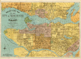
Vancouver, B.C. zoning diagram
Part of City of Vancouver Archives technical and cartographic drawing collection
Part is the front side of an unfolded pamphlet. The sheet contains general information on historical events, why planning is conducted, zoning, general facts about the city and the province, a statement of purpose for town planning, and a list of applicable statutes.
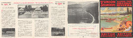
Along the gulf coast riviera by Union Steamships
Part of City of Vancouver Archives technical and cartographic drawing collection
Part is the outer/front side of an unfolded brochure for Union Steamships Limited. The sheet described various tourist destinations along the southern coast that could be reached by Union Steamships services, with information on sights, fares, etc. The sheet also includes photographs of recreation areas around Sechelt.
Union Steamships (Vancouver, B.C.)

Part of City of Vancouver Archives technical and cartographic drawing collection
Part is the outer/back side of an unfolded brochure for Union Steamships. The sheet includes text describing the company's services and vessels, photographs of various vessels and locations served, and a map showing the various routes in the area.
Union Steamships (Vancouver, B.C.)

Map of Vancouver, British Columbia
Part of City of Vancouver Archives technical and cartographic drawing collection
Part is a map showing Vancouver city streets, electric railways, bus lines, city districts and indicating city boundaries with a shaded red line. Concentric circles spaced one mile apart emanate from City Hall's location on the map.

Map of the municipalities of New Westminster, British Columbia
Part of City of Vancouver Archives technical and cartographic drawing collection
Part consists of the map component of a pamphlet. The map shows the location of churches, school, canaries, sawmills, backyards, tanneries, woolen mills, hatcheries, roads, and railways on a map which depicts the area of Greater Vancouver from the Gulf of Georgia east to Harrison Lake and south to the United States border.

Dispersal routes for the Vancouver zone
Part of City of Vancouver Archives technical and cartographic drawing collection

Insurance Plan of Port Coquitlam : sheet 3
Part of City of Vancouver Archives technical and cartographic drawing collection
Part contains a section of the insurance plan covering the area bounded by an unnamed creek, Kingsway Avenue, and Atkins Avenue. Map shows legal descriptions, street widths, building dimensions and types (dwelling, office, industrial, other commercial use), names of businesses, and other features of the built environment relevant to insurance claims.

Part of City of Vancouver Archives technical and cartographic drawing collection
Part is the reverse side of a tourism brochure, containing a tourist map of Greater Vancouver, showing major roads, locations of tourist attractions and recreational sites, and routes into Vancouver.

Part of City of Vancouver Archives technical and cartographic drawing collection
Part is the front sheet of an unfolded tourism brochure showing Vancouver tourist attractions, The sheet includes a map of downtown Vancouver, with transportation information, a map of the roads in Stanley Park, photographs and information on various sites and attractions in the city, as well as general promotional information.

Vancouver city and suburban lines
Part of City of Vancouver Archives technical and cartographic drawing collection
Part is the back side of an informational pamphlet published by the BC Electric Railway Co. showing street car lines, interurban lines, bus routes and parks.

Part of City of Vancouver Archives technical and cartographic drawing collection
Part is the inner sheet of an unfolded brochure, showing lots offered for sale in the northern portion of District Lot 540.

Part of City of Vancouver Archives technical and cartographic drawing collection
Item is a zoning map of the City of Vancouver, with zoning indicated by colour coding and the types of construction characteristic of each zoning type.

Guide map. Vancouver-New Westminster. Burnaby and North Shore municipalities
Part of City of Vancouver Archives technical and cartographic drawing collection
Part is a map which shows city streets, local areas, schools, hospitals, firehalls, parks and golf courses as well as railways, street railways and interurbans and bus routes.

City of Vancouver. Fifth Sale. Lots and blocks in Lot 540
Part of City of Vancouver Archives technical and cartographic drawing collection
Part is the outer sheet of an unfolded brochure advertising the sale of lots owned by the provincial government. The map included in the sheet is an index map of greater Vancouver, showing the location of District Lot 540.
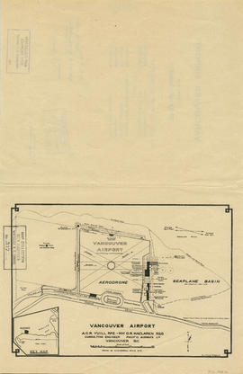
Part of City of Vancouver Archives technical and cartographic drawing collection
Part is a map shows a proposed plan for the design of Vancouver Airport at Spanish Banks, along with surrounding gardens, a stadium, parks and beaches.
Part of City of Vancouver Archives technical and cartographic drawing collection
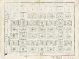
Part is a map of District Lot 69, showing blocks and lots in blocks 12 to 49.

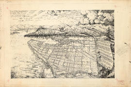
Bird's eye view of Vancouver, B.C.
Part of City of Vancouver Archives technical and cartographic drawing collection
Part is an aerial rendering of Vancouver looking westward from a viewpoint east of Hastings Township. The Broadview area is highlighted.

Part of City of Vancouver Archives technical and cartographic drawing collection
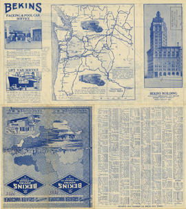
Part is a street map of Greater Vancouver, including West Vancouver, North Vancouver, and the western portion of Burnaby. The map includes concentric circles centred on the Bekins head office in downtown, noting distances in miles.
Part of City of Vancouver Archives technical and cartographic drawing collection
Part is a map of the greater Vancouver area, showing communities across the region, with pictographs representing various communities. The map also includes a mileage table showing driving distances between various communities in Greater Vancouver.
British Columbia. Travel Bureau
Indexed map of Greater Vancouver
Part of City of Vancouver Archives technical and cartographic drawing collection
Part is the front sheet of an unfolded brochure. The sheet includes illustrations, an index and guide to strets and avenues of Vancouver, promotional text and photographs of the company's operations and a map of the company's service area outside Vancouver.

Part of City of Vancouver Archives technical and cartographic drawing collection
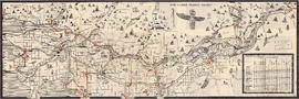
Part is the right-hand half of a map sheet that has been mounted onto linen. The sheet shows Vancouver streets, District Lots, blocks and lots as well as main city infrastructure from Willow Street to the eastern edge of the City.

Tourist map of Greater Vancouver
Part of City of Vancouver Archives technical and cartographic drawing collection
Part is a sheet with two maps. The main map shows a pictorial view of Greater Vancouver, including the location of major roads and tourist attractions. Drawings of "the most important single objects on totem poles of the Pacific Northwest Indians" form a decorative border. The inset map shows downtown Granville Street and the location of the Scenery Shop.

Part of City of Vancouver Archives technical and cartographic drawing collection
Part is the left-hand half of a map sheet that has been mounted onto linen. The sheet shows Vancouver streets, District Lots, blocks and lots as well as main city infrastructure from the western edge of the City east to Willow Street. The inset map shows Stanley Park.

Part of City of Vancouver Archives technical and cartographic drawing collection
Part is the cover and back page of a pamphlet. The back page is an index map of the province, showing the area covered by the main map on the interior (verso) sheet of the pamphlet.

The service route to - from - through industrial southwestern British Columbia
Part of City of Vancouver Archives technical and cartographic drawing collection
Part is a map depicting Greater Vancouver east to Chilliwack, showing the locations of B.C. Hydro rail routes, routes of other rail companies, interchanges, industrial development sites, and municipal boundaries and 1961 census figures.

Part of City of Vancouver Archives technical and cartographic drawing collection
Part is the verso side of the pamphlet, which includes a street index, list of places of general interst and their location on on the main map, a list of B.C.E.R. routes, and an index of schools shown on the map. The page includes two inset maps, one of downtown Vancouver and one of Richmond, including a road index.

Transit system map of Greater Vancouver, B.C.
Part of City of Vancouver Archives technical and cartographic drawing collection
Part is a map sheet with a main map showing the various B.C. Electric transit routes in Greater Vancouver, including Vancouver, Richmond, North Vancouver, Burnaby and New Westminster.
Indexed guide map of the City of Vancouver and suburbs
Part of City of Vancouver Archives technical and cartographic drawing collection
Part is a map showing District Lots in Vancouver, South Vancouver, Point Grey, Burnaby, Richmond, New Westminster, West Vancouver, and North Vancouver, as well as concentric circles denoting distances in miles from the intersection of Main Street and Hastings Street in downtown Vancouver.

Part of City of Vancouver Archives technical and cartographic drawing collection
Part is the back sheet of the unfolded pamphlet, which is a map showing roads, trails, geographical features and attractions.
![Howe Sound - Burrard Inlet [Burrard Inlet portion]](/uploads/r/null/f/8/5/f8523992bb5d5e0c1391f2dea183041a54a2d2470eb4047bb29958a0d835ae95/fdf9563d-923e-468a-a494-3ff190294b91-MAP30b_142.jpg)
Howe Sound - Burrard Inlet [Burrard Inlet portion]
Part of City of Vancouver Archives technical and cartographic drawing collection
Part shows the Lower Mainland and Burrard Inlet from Howe Sound in the west to Indian Arm in the east. Map shows topographic contour lines, elevations, lakes, streams and other natural features, roads, railways, communication lines, cities and other settlements, and land, timber, and mineral surveys by number. Includes a list of sources of information.
![Howe Sound - Burrard Inlet [Howe Sound portion]](/uploads/r/null/7/a/1/7a1896077ddc37a7e16ac2d7e42a66031e13e11a9d966c43fca06cbb56f8bd96/5edd8d92-d3cd-4663-8fdd-996b3ae7a402-MAP30a_142.jpg)
Howe Sound - Burrard Inlet [Howe Sound portion]
Part of City of Vancouver Archives technical and cartographic drawing collection
Part shows the Lower Mainland and Howe Sound from Britannia Beach in the northwest to Indian Arm in the southeast. Map shows topographic contour lines, elevations, lakes, streams and other natural features, roads, railways, communication lines, cities and other settlements, and land, timber, and mineral surveys by number.

Part of City of Vancouver Archives technical and cartographic drawing collection
Part contains a street map of Greater Vancouver showing highways, municipal boundaries, parks and golf courses.

Part of City of Vancouver Archives technical and cartographic drawing collection
Pictorial map of Greater Vancouver
Part of City of Vancouver Archives technical and cartographic drawing collection
Part contains an illustrated map (not drawn to scale) of Vancouver and the surrounding area and a celebratory poem. An annotation at the edge of the drawing proposes inverting two lines of the poem.

Part of City of Vancouver Archives technical and cartographic drawing collection
Part is an overlay designed to be used with a pictorial map of Greater Vancouver to show key dates in various areas.

Bus routes, city of Vancouver, November 26th 1937
Part of City of Vancouver Archives technical and cartographic drawing collection

Page from "The Buzzer," November 26, 1937, showing map of bus routes
Part of City of Vancouver Archives technical and cartographic drawing collection
Part is the verso of a hand-drawn map showing bus routes in Vancouver, and contains a page from the November 26, 1937 edition of "The Buzzer." The page contains information on bus routes in Vancouver and a reproduction of the hand-drawn map.

Tidal current chart, Vancouver Harbour : one hour after maximum flood at First Narrows
Part of City of Vancouver Archives technical and cartographic drawing collection

Tidal current chart, Vancouver Harbour : two hours after maximum flood at First Narrows
Part of City of Vancouver Archives technical and cartographic drawing collection

Tidal current chart, Vancouver Harbour : three hours after maximum flood at First Narrows
Part of City of Vancouver Archives technical and cartographic drawing collection

Tidal current chart, Vancouver Harbour : one hour before maximum flood at First Narrows
Part of City of Vancouver Archives technical and cartographic drawing collection

Tidal current chart, Vancouver Harbour : two hours before maximum flood at First Narrows
Part of City of Vancouver Archives technical and cartographic drawing collection

Tidal current chart, Vancouver Harbour : maximum flood at First Narrows
Part of City of Vancouver Archives technical and cartographic drawing collection

Tidal current chart, Vancouver Harbour : three hours after maximum ebb at First Narrows
Part of City of Vancouver Archives technical and cartographic drawing collection

Tidal current chart, Vancouver Harbour : one hour after maximum ebb at First Narrows
Part of City of Vancouver Archives technical and cartographic drawing collection

Tidal current chart, Vancouver Harbour : two hours after maximum ebb at First Narrows
Part of City of Vancouver Archives technical and cartographic drawing collection