Sectional map of Vancouver showing streets, block and lot outlines, and building perimeters : Map 71 : Cypress Street to Oak Street and 49th Avenue to 57th Avenue
Sectional map of Vancouver showing streets, block and lot outlines, and building perimeters : Map 72 : Oak Street to Quebec Street and 46th Avenue to 57th Avenue
Sectional map of Vancouver showing streets, block and lot outlines, and building perimeters : Map 73 : Quebec Street to Inverness Street and 47th Avenue to 57th Avenue
Sectional map of Vancouver showing streets, block and lot outlines, and building perimeters : Map 74 : Inverness Street to Nanaimo Street and 49th Avenue to 61st Avenue
Sectional map of Vancouver showing streets, block and lot outlines, and building perimeters : Map 75 : Nanaimo Street to Kerr Street and 49th Avenue to Bobolink Avenue
Sectional map of Vancouver showing streets, block and lot outlines, and building perimeters : Map 76 : Kerr Street to Boundary Road and 49th Avenue/48th Avenue to Rosemont Drive
Sectional map of Vancouver showing streets, block and lot outlines, and building perimeters : Map 78 : Kerr Street to Boundary Road and S.E. Marine Drive to the North Arm of the Fraser River
Sectional map of Vancouver showing streets, block and lot outlines, and building perimeters : Map 79 : Gladstone Street/Nanaimo Street to Kerr Street and Bobolink Avenue to the North Arm of the Fraser River
Sectional map of Vancouver showing streets, block and lot outlines, and building perimeters : Map 8 : Piers at Burrard Inlet between Main Street and Clark Drive
Sectional map of Vancouver showing streets, block and lot outlines, and building perimeters : Map 80 : Inverness Street to Gladstone Street/Nanaimo Street and 61st Avenue to the North Fork of the North Arm of the Fraser River
Sectional map of Vancouver showing streets, block and lot outlines, and building perimeters : Map 81 : Main Street to Inverness Street and 57th Avenue to S.E. Marine Drive
Sectional map of Vancouver showing streets, block and lot outlines, and building perimeters : Map 82 : Main Street to Crompton Street and S.E. Marine Drive to the North Fork of the North Arm of the Fraser River
Sectional map of Vancouver showing streets, block and lot outlines, and building perimeters : Map 83 : Fremlin Street to Main Street and 57th Avenue to 67th Avenue/S.W. Marine Drive
Sectional map of Vancouver showing streets, block and lot outlines, and building perimeters : Map 84 : Laurel Street to Main Street and 67th Avenue/S.W. Marine Drive to the North Fork of the North Arm of the Fraser River
Sectional map of Vancouver showing streets, block and lot outlines, and building perimeters : Map 85 : Laburnum Street to Fremlin Street and 57th Avenue to 68th Avenue/67th Avenue
Sectional map of Vancouver showing streets, block and lot outlines, and building perimeters : Map 86 : Angus Drive to Laurel Street and 68th Avenue/67th Avenue to the North Arm of the Fraser River
Sectional map of Vancouver showing streets, block and lot outlines, and building perimeters : Map 87 : Barnard Street to Heather Street and 75th Avenue/Kent Avenue South to the North Arm of the Fraser River
Sectional map of Vancouver showing streets, block and lot outlines, and building perimeters : Map 88 : MacDonald Street to Laburnum Street/Angus Drive and 57th Avenue to the North Arm of the Fraser River
Sectional map of Vancouver showing streets, block and lot outlines, and building perimeters : Map 89 : Area west of Angus Drive to Barnard Street and S.W. Marine Drive to the North Arm of the Fraser River
Sectional map of Vancouver showing streets, block and lot outlines, and building perimeters : Map 9 : Main Street to Clark Drive and Burrard Inlet to Prior Street
Sectional map of Vancouver showing streets, block and lot outlines, and building perimeters : Map 90 : Iona Island to Wood Island and Celtic Avenue to Sea Island
Sectional map of Vancouver showing streets, block and lot outlines, and building perimeters: Map 5 : Lagoon Street to Nicola Street and Robson Street to English Bay
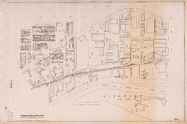
Sheet 10A [Sydney Street to 22nd Avenue to Knight Street to 28th Avenue]
Sheet 10B [Slocan Street to 23rd Avenue to Sidney Street to 29th Avenue]
Sheet 10C [Gladstone Srteet to 29th Avenue to Knight Street to 37th Avenue]
Sheet 10D [Chambers Street to 29th Avenue to Gladstone Street to 37th Avenue]
Sheet 11A [Victoria Drive to 37th Avenue to Knight Street to 45th Avenue]
Sheet 11B [Wales Street to 37th Avenue to Victoria Drive to 45th Street]
Sheet 11C [Victoria Drive to 45th Avenue to Knight Street to 53rd Avenue]
Sheet 11D [Vivian Street to 45th Avenue to Gladstone Street to 53rd Avenue]
Sheet 12A [Duff Street to 53rd Avenue to Knight Street to 61st Avenue]
Sheet 12B [Vivian Street to 53rd Avenue to Duff Street to 61st Avenue]
Sheet 12C [Victoria Drive to 61st Avenue to Knight Street to Fraser River]
Sheet 12D [Harrison Drive to 61st Avenue to Victoria Drive to SW Marine Drive]
Sheet 13A [Foot of Victoria Drive to Fraser River]
Sheet 13B [SW Marine Drive to Duff Street to Fraser River]
Sheet 13C [Kinross Street to Kent Avenue to Jellicoe Street to Fraser River]
Sheet 13D [Boundary Road to Ellis Avenue to Kinross Street to Fraser River]
Sheet 14A [Hawks Avenue to Burrard Inlet to Main Street to Powell Street]
Sheet 14B [Clark Drive to Burrard Inlet to Kawks Avenue to Powell Street]
Sheet 15D [Clark Drive to Grandview Highway to Fraser Street to Broadway]
Sheet 16A [Fraser Street to Broadway to Main Street to 16th Avenue]
Sheet 16B [Clark Drive to Broadway to Fraser Street to 16th Avenue]
Sheet 16C [Fraser Street to 16th Avenue to Main Street to 25th Avenue]
Sheet 16D [Knight Street to 16th Avenue to Fraser Street to King Edward Avenue]
Sheet 17A [Fraser Street to 25th Avenue to Main Street to 33rd Avenue]
Sheet 17B [Knight Street to King Edward Avenue to Fraser Street to Durward Avenue]
Sheet 17C [Fraser Street to 33rd Avenue to Main Street to 41st Avenue]
Sheet 17D [Knight Street to Durward Avenue to Fraser Street to 41st Avenue]
Sheet 18A [Fraser Street to 41st Avenue to Quebec Street to 49th Avenue]


![Sheet 10A [Sydney Street to 22nd Avenue to Knight Street to 28th Avenue]](/uploads/r/null/6/8/a/68a5ee3c33e4a16ab15608383f6f4c59030ccb98434d74a4b9841d8baeb01a4f/797e1ea9-b769-4c53-a498-ddc837d8d6b0-LEG1153_142.jpg)
![Sheet 10B [Slocan Street to 23rd Avenue to Sidney Street to 29th Avenue]](/uploads/r/null/7/a/6/7a643182fb12f452f594aa241aacdb21982fb1e70249d145f3f8edff509857db/bec9da93-10c1-43a2-98ad-4a46771fceb9-LEG1153_142.jpg)
![Sheet 10C [Gladstone Srteet to 29th Avenue to Knight Street to 37th Avenue]](/uploads/r/null/e/e/6/ee677093b334dfa6504db28523f8861a78222a2259d95572fe2ef5131318e857/8a482765-fdbe-4162-9d22-e5bd1c6e3ff2-LEG1153_142.jpg)
![Sheet 10D [Chambers Street to 29th Avenue to Gladstone Street to 37th Avenue]](/uploads/r/null/d/d/7/dd7db9c8c09a85f2d91d18832f6ed2cfe09f88d6850111e170876ccfaec70043/9668563c-4058-4346-ae11-a99c8a48a605-LEG1153_142.jpg)
![Sheet 11A [Victoria Drive to 37th Avenue to Knight Street to 45th Avenue]](/uploads/r/null/6/e/a/6ead9db0025ca23bfc2bcb8dcd095d7cd06a2e60497eb4f6de3c4729d163bf79/b80628c0-b5ff-4789-80b8-4077ef9b593b-LEG1153_142.jpg)
![Sheet 11B [Wales Street to 37th Avenue to Victoria Drive to 45th Street]](/uploads/r/null/1/0/e/10e216d966349146e6c8bcd323ab9c23bd8d76a41fb67e813dc85c3b45d02a85/67f3269b-d839-420f-a865-7504f4573fae-LEG1153_142.jpg)
![Sheet 11C [Victoria Drive to 45th Avenue to Knight Street to 53rd Avenue]](/uploads/r/null/1/d/b/1db11c78e6cbe071c16384954f6cd1c4c7422e511137dfb0d9e475b02429a91e/db8e4f44-94b1-4019-bde7-af2a3bf524f7-LEG1153_142.jpg)
![Sheet 11D [Vivian Street to 45th Avenue to Gladstone Street to 53rd Avenue]](/uploads/r/null/9/6/9/96934c830e4481712138cb8f3cd33681a83ae902562312b7cbd5cd275b1b0da6/bff15411-9432-4e56-b26c-0df02be250e3-LEG1153_142.jpg)
![Sheet 12A [Duff Street to 53rd Avenue to Knight Street to 61st Avenue]](/uploads/r/null/6/2/6/626abd9097f522a3a00f5729e122baf25c1abca24eaebe891f16c22dc206513b/e0ee89cb-6da7-4421-88de-a697d79f3a18-LEG1153_142.jpg)
![Sheet 12B [Vivian Street to 53rd Avenue to Duff Street to 61st Avenue]](/uploads/r/null/e/3/c/e3c8b6efb1d27795c9f95fe0f4f635f96177ec6611aee5c04eb73461e3e81764/b44ecc2f-977b-4819-b58e-558f10cb6378-LEG1153_142.jpg)
![Sheet 12C [Victoria Drive to 61st Avenue to Knight Street to Fraser River]](/uploads/r/null/a/a/4/aa437dca1bb56cbf7a607a6aedce32ae3371be7f3cbfb2e70b74c5e77475af88/6b33c2e7-54fb-44b5-9041-deaad0006465-LEG1153_142.jpg)
![Sheet 12D [Harrison Drive to 61st Avenue to Victoria Drive to SW Marine Drive]](/uploads/r/null/1/0/d/10dafbfa4cf4bf1888a863053dec25b30a177b6441646761b09f6468dee14074/e8338aff-cbd3-4f79-8072-3d661cdd1bd1-LEG1153_142.jpg)
![Sheet 13A [Foot of Victoria Drive to Fraser River]](/uploads/r/null/e/0/7/e076af466f7ca711ddf57dd662031efc3cc4c28e6408b4e31ea3fe7270ab18c7/d6f87673-7469-46e1-a7df-652efb652390-LEG1153_142.jpg)
![Sheet 13B [SW Marine Drive to Duff Street to Fraser River]](/uploads/r/null/0/3/4/03421275306943b3d9eb9b3aaaa73979580d2e415b3a634dee138ceee5ac2b65/e60534ef-16bb-4a15-9951-7bbb070a9b45-LEG1153_142.jpg)
![Sheet 13C [Kinross Street to Kent Avenue to Jellicoe Street to Fraser River]](/uploads/r/null/3/5/2/352b07afbc524c7ddccf37b3e3d97b12d5c0be97fad31325d508b5732250a89b/bbf4f6ac-22ae-415d-9327-d6623a7779a9-LEG1153_142.jpg)
![Sheet 13D [Boundary Road to Ellis Avenue to Kinross Street to Fraser River]](/uploads/r/null/b/2/7/b27058cc4ac42327fbb3aab78b65df9c8b942cbe642a9f79ec83473c1e7ac265/de84ac8c-0385-4ab1-bf1a-3f06a1d433f3-LEG1153_142.jpg)
![Sheet 14A [Hawks Avenue to Burrard Inlet to Main Street to Powell Street]](/uploads/r/null/e/2/8/e288aac0af2470fbe41a5a5898348a18e7de697b091d3e45ec41fa072ec287e6/3bbe6aae-c655-48cd-a519-fc20dc66b684-LEG1153_142.jpg)
![Sheet 14B [Clark Drive to Burrard Inlet to Kawks Avenue to Powell Street]](/uploads/r/null/8/0/7/807b43d4c6da80a78ccf0b257afc77acb7f28fd695221ce80613ebc9f968a0f5/79d752d8-de33-4bad-b374-15b82083bc6f-LEG1153_142.jpg)
![Sheet 15D [Clark Drive to Grandview Highway to Fraser Street to Broadway]](/uploads/r/null/d/0/e/d0e220b834f59ce819f81267f1e4cc2724f031820858ed76bb176c0f78859d08/7e5618ca-ce76-4c90-9c1c-9042a16f0b07-LEG1153_142.jpg)
![Sheet 16A [Fraser Street to Broadway to Main Street to 16th Avenue]](/uploads/r/null/0/c/7/0c74c17cd5eb576019a803e39c6192464bf755b44c7bf8c2af8bc91a4f0c29b2/3b3792a9-4ef2-45a6-a9a6-e8470ab8bc87-LEG1153_142.jpg)
![Sheet 16B [Clark Drive to Broadway to Fraser Street to 16th Avenue]](/uploads/r/null/f/6/4/f64fe8a94788508f9a26125039fd52a10d68c57a6a7955d76b2c90b54cd5bee5/9f5d808d-0e32-404e-9c2d-0cf2ffb68584-LEG1153_142.jpg)
![Sheet 16C [Fraser Street to 16th Avenue to Main Street to 25th Avenue]](/uploads/r/null/1/1/6/1163864e8162291b537da118276007a2b3de69380e8b078eb0d088d795995f87/afb49aec-b5bb-4c60-9401-d4ef89479635-LEG1153_142.jpg)
![Sheet 16D [Knight Street to 16th Avenue to Fraser Street to King Edward Avenue]](/uploads/r/null/5/0/1/5011c29f81b0d7a5d44c56d2ca55bafb60ba5cbf140db322b6645c3c623d3bfe/0fc650fb-612f-43cf-bcf2-f27bcd72fc10-LEG1153_142.jpg)
![Sheet 17A [Fraser Street to 25th Avenue to Main Street to 33rd Avenue]](/uploads/r/null/3/5/e/35efa02285fe97cbbc78720917aa8f41cad1a29600cbbaae19da1739512c2cf6/201df1a8-a4c7-4b71-8d0f-44e0e32ed2a6-LEG1153_142.jpg)
![Sheet 17B [Knight Street to King Edward Avenue to Fraser Street to Durward Avenue]](/uploads/r/null/1/a/f/1aff8dcb09ab65378dfafeb29d7118ccc19705c70cbb15bdad682b0a0909f633/7d7ac22a-48d6-4e8e-8d72-5d4ff3e31715-LEG1153_142.jpg)
![Sheet 17C [Fraser Street to 33rd Avenue to Main Street to 41st Avenue]](/uploads/r/null/5/0/f/50f7c2c32c74cf702ebabbc3345a81811979b51b3074175b7500158f27725381/b5798db5-5cd1-40b1-ba70-17af70186dc8-LEG1153_142.jpg)
![Sheet 17D [Knight Street to Durward Avenue to Fraser Street to 41st Avenue]](/uploads/r/null/6/b/9/6b937fa197e37d6f7b871772b460a37f71b63a0cb6fbbe578e2042c79e665327/9fac95fe-f944-435f-83e7-3a79eac6809b-LEG1153_142.jpg)
![Sheet 18A [Fraser Street to 41st Avenue to Quebec Street to 49th Avenue]](/uploads/r/null/c/8/0/c80a4237c9c4c70aad340c2fb1df174b7ecf854e10b2268e00a49c5535b69999/37febe49-c3ee-4548-9d7d-e61b05fb8c01-LEG1153_142.jpg)