![[Altar], St. James' church [303 East Cordova Street]](/uploads/r/null/6/2/624c6f3ccf4595188db917d91c3a4df130b0949ffd6a69369b50bf8bfb6d06e8/ad0a2c33-ebbf-436c-8c85-add2ba401001-A02785_142.jpg)
[Altar], St. James' church [303 East Cordova Street]
- AM336-S3-2-: CVA 677-940
- Item
- [ca. 1972]
1172 results with digital objects Show results with digital objects
[Altar], St. James' church [303 East Cordova Street]
![[Automobile race at Hastings Park]](/uploads/r/null/f/e/fecbb87c49324f16ec88ebe230aa5f60d5748261b263ba6693892650b33cb652/fd407d75-4a99-4ede-b478-c9fbf07b98e8-A02853_142.jpg)
[Automobile race at Hastings Park]
Photograph shows a grandstand full of people, and three cars racing.
![[Automobile race at Hastings Park]](/uploads/r/null/f/1/f15b26da1a6b394279c08b4523f8e2db0a685edecee91b75d14d452224b315ac/c9b01fd1-723c-4a72-9f2a-0a0dc30567b6-A02854_142.jpg)
[Automobile race at Hastings Park]
Photograph shows a grandstand full of people, and cars parked on the track.
![[Bathers at] Second Beach](/uploads/r/null/2/3/23876e534a86b0219c9aef5a1fa4a84dcc2deadd408bcef2cf7efc49a3483523/070853b4-cac9-4baf-9e4d-5cfc32fc2900-A01797_142.jpg)
![[Boats in] Coal Harbour](/uploads/r/null/4/e/4e0ce74158796911dcd444ae208a0139e91a4251c536cf44042cbf4336ab4be4/9190958d-05ac-45a7-ae92-6df410a7bab9-A01926_142.jpg)
Photograph shows various types of boats in the harbour, with Stanley Park in the background.
![[Cable attached to fallen log in wooded area]](/uploads/r/null/2/8/283ce8a727d87c06c04a12639c55505e61459d1c7f8b6dd9a29fc1b87221f314/d262a93e-550f-4b30-a673-9424a2993ebc-A02730_142.jpg)
[Cable attached to fallen log in wooded area]
Original accompanying envelope was labelled "B.C. Mills Timber and Trading Co. Operation, Rock Bay, Vancouver, Island, K.Y."
![[Cliff and river], Capilano Canyon](/uploads/r/null/3/e/3e8447ddcb3c0c7a0232c20f6608f812fb77b7b15f6990c0ebad31889b21c276/ab17e8d9-a24a-4cfe-acc2-849b1fe0647b-A02692_142.jpg)
[Cliff and river], Capilano Canyon
![[Coal Harbour, showing part of Stanley Park, Deadman's Island, and houseboats]](/uploads/r/null/1/2/12067ca2ea5ea0ff39ee45868194a05deff43c7c02b79dc9558e8710362bcd57/cc755324-9751-4940-ac1f-281c8e8867e0-A02323_142.jpg)
[Coal Harbour, showing part of Stanley Park, Deadman's Island, and houseboats]
![[Coastline area, showing mountain in the background]](/uploads/r/null/a/b/abc42dea138a46f4f29e17586a11d86afd9668a373cf28dd0ace53dbd6a1b9d1/33ea1d70-b4fa-45f1-b291-a7bd341206f3-A02733_142.jpg)
[Coastline area, showing mountain in the background]
Original accompanying envelope was labelled "B.C. Mills Timber and Trading Co. Operation, Rock Bay, Vancouver, Island, K.Y."

A note on the original mounting board reads: "Geology. Sand cliffs at Boundary Bay, near Vancouver, Ancient sea bottom laid down when the Gulf of Georgia was fresh water. Van. Nat. History - Timms."
![Corner Granville and Hastings Street, Vancouver, B.C. [showing Canadian Bank of Commerce building]](/uploads/r/null/9/5/9542a3105c6ed9041456654b69b4663e394f664fad514e7e36089eae16c3675c/a380f7ab-b8a5-4c3f-ab68-3dd606cf399c-A02445_142.jpg)
Corner Granville and Hastings Street, Vancouver, B.C. [showing Canadian Bank of Commerce building]
![Corner of Westminster Avenue [later Main Street] and Hastings Street, Vancouver, B.C.](/uploads/r/null/4/4/4464dc8796c1bba530d578b8f8a385d7f386457a7736e504a056429e78de7f68/3a75d8f7-fdee-41a3-8697-36d0015572fa-A02421_142.jpg)
Corner of Westminster Avenue [later Main Street] and Hastings Street, Vancouver, B.C.
Photograph shows a streetcar, pedestrians, a cyclist, a cart, and buildings on the street.

A note on the original mounting board reads: "'The morning's promise.' Early morning on Howe Sound, Vancouver, Canada. Tidal salt water of the Pacific Ocean, explored by Captain Vancouver, over 160 years ago."
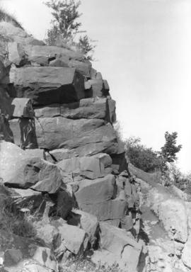
Five sided basalt, False Creek
A note on the original mounting board reads: "Geology. Five sided basalt. Eruptives of False Creek, south hillsides. Vancouver, B.C. Van. Nat. History - Timms."
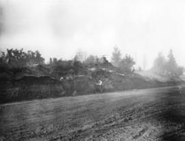
Great Fraser Midden [showing skeleton]
Photograph shows a cross section of the Midden, showing skeletal remains near the bottom. Notes on the back of the photograph contain information regarding permission given by Timms to the City Museum to use the image in an exhibit.
![Hastings at Cambie [showing streetcar, Woodward's cart, and corner of the Court House garden]](/uploads/r/null/d/4/d4767b71244181bb50609e37d28c55c9bff05260aa2c597c5f27e55e9da0a818/1efa0c99-d45b-4e24-bfee-856b5f970950-A02413_142.jpg)
Hastings at Cambie [showing streetcar, Woodward's cart, and corner of the Court House garden]

Hastings Street at Columbia, looking east
An accompanying label reads: "This is Hastings Street East of Columbia Avenue. Many of the old wooden buildings have vanished. The barber poles and the bicycle racks and the old wooden sidewalks, with an occasional nail, kept us from going to sleep as we did our shopping. Timms Photo."

Hastings Street at Granville Street
Photograph shows pedestrians, streetcars, the Birks Clock, and a banner announcing baseball games.
![Interior of Pioneer's Association Museum (Old Hastings Mill Store) [1575 Alma Street, Vancouver]](/uploads/r/null/e/3/e3dc34ac96b39496a16764ca9f2f3cbd29f527a89f61fc99604b9ab117605c27/b402c75d-f487-4410-a534-1f39150c1810-A02002_142.jpg)
Interior of Pioneer's Association Museum (Old Hastings Mill Store) [1575 Alma Street, Vancouver]
Photograph shows a piano and other artifacts in the museum.
Marine Drive cut through Great Fraser Midden
Photograph shows a man examining an object near the cross section of the midden. The photograph also shows a briefcase labelled "Timms Photo. Co."

Orange Parade on Georgia Street
Photograph mounting contains a label which reads: "Orange Parade, July 12th, 1907. 'Old Time Band.' - where are the boys of the old bridgade? Note the bicycle path - $1.00 per year license. Georgia St. W. on way to Stanley Park."

Parade, Cordova Street, Dominion Day
Photograph shows soldiers with band marching down street, with spectators on the sidewalks.

Rocky ramparts of Bowen Island
A note on the original mounting board reads: "Geology. Rocky ramparts of Bowen Island. Among the Igneous formations. Miller's Landing, Hower Sound. Van. Nat. History - Timms."

The Empire's Commerce, S. S. Bellerophen
Photograph shows ships at dock.
![The nave, north and south transepts, from the chancel [St. Andrew's Wesley United Church]](/uploads/r/null/e/9/e926c427f686de90fffbe61232de072e6e368bd15144818b1c94feeecb7cb389/faf65e2b-d72c-499f-ab6f-31b25ee05bd5-A02032_142.jpg)
The nave, north and south transepts, from the chancel [St. Andrew's Wesley United Church]

Volcanic mud and basaltic outcropping, False Creek
A note on the original mounting board reads: "Geology. Volcanic mud and basaltic outcropping. South side of False Creek, Vancouver, B.C. Van. Nat. History - Timms."