
Fraser River - Deas Island sheet
- AM1594-MAP 1157-: LEG1153.045
- Item
- 1921
Part of City of Vancouver Archives technical and cartographic drawing collection
Fraser River - Deas Island sheet
Part of City of Vancouver Archives technical and cartographic drawing collection

Fraser River - Tilbury Island sheet
Part of City of Vancouver Archives technical and cartographic drawing collection

Fraser River - Annacis Island sheet
Part of City of Vancouver Archives technical and cartographic drawing collection

Fraser River - New Westminster sheet
Part of City of Vancouver Archives technical and cartographic drawing collection

Fraser River - Sand heads sheet
Part of City of Vancouver Archives technical and cartographic drawing collection

Part of City of Vancouver Archives technical and cartographic drawing collection

Fraser River - Steveston sheet
Part of City of Vancouver Archives technical and cartographic drawing collection

Chart of the coast of British Columbia, north of latitude 51 degrees
Part of City of Vancouver Archives technical and cartographic drawing collection
Item is a hydrographic chart depicting the coastline adjacent to the Queen Charleoot Islands, showing rivers, islands, soundings, and physical features.

Plan of the Kaminstiquia River and Plan showing survey and soundings of Lake Ellen and Nipigon Bay
Part of City of Vancouver Archives technical and cartographic drawing collection
![Chart of Nepigon [Nipigon] Bay. Lake Superior](/uploads/r/null/e/6/0/e6083525f33c7a6d0dd05f840915433768b0cfaed2c5b564153e3bfb5830f77e/8dd4e8d6-c36f-488f-a1bb-7aea7e098200-LEG1153_142.jpg)
Chart of Nepigon [Nipigon] Bay. Lake Superior
Part of City of Vancouver Archives technical and cartographic drawing collection
Item is a hydrographic chart depicting steamboat routes, roads, towns, rivers, soundings, and relief hachures on adjacent land areas.
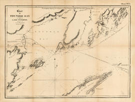
Chart of Thunder Bay. Lake Superior
Part of City of Vancouver Archives technical and cartographic drawing collection
Item is a hydrographic chart depicting steamboat routes, roads, towns, rivers, soundings, and relief hachures on adjacent land areas.

Sketch plan of the mouth of the Saskatchewan River, from Hinds Exploring Expedition
Part of City of Vancouver Archives technical and cartographic drawing collection
Item is a map depicting physical features and cross sections.

Map from the Pacific Ocean across the Rocky Mountain zone
Part of City of Vancouver Archives technical and cartographic drawing collection
Item is a map depicting rivers, lakes, towns, and proposed railway routes.

Map to accompany the report on the Exploration Survey of the Canadian Pacific Railway
Part of City of Vancouver Archives technical and cartographic drawing collection
Item is a map depicting the area from Lake Manitoba to Lake Ontario, showing physical features, towns and railways routes.
![Plate 163 [Key Plan of North Vancouver]](/uploads/r/null/e/1/d/e1d59c4aba0a20f0522dd57d1ecfbcc6fa0e15d2cb581616d819932b7b4485b7/be98b40c-82d0-4d47-97d2-e5bc54e3e904-1974-100_142.jpg)
Plate 163 [Key Plan of North Vancouver]
Part of City of Vancouver Archives technical and cartographic drawing collection
![Plate 164 [Lonsdale Avenue to Second Street to Chesterfield Avenue to Burrard Inlet]](/uploads/r/null/b/c/5/bc5801cb1cab9f718c08d5e85247acf3c6c6d41621bd633be9636327b722a9cd/db55d2fa-bc36-4407-a98b-9c062774aa12-1974-100_142.jpg)
Plate 164 [Lonsdale Avenue to Second Street to Chesterfield Avenue to Burrard Inlet]
Part of City of Vancouver Archives technical and cartographic drawing collection
![Plate 165 [St. Georges Road to Second Street to Lonsdale Avenue to Burrard Inlet]](/uploads/r/null/7/4/b/74bf056c6f380a72cc2df80556ee1fab18f65d4b16d8d010c950578becb6ee53/d1a63bcb-2baa-4bed-9444-00a74944242c-1974-100_142.jpg)
Plate 165 [St. Georges Road to Second Street to Lonsdale Avenue to Burrard Inlet]
Part of City of Vancouver Archives technical and cartographic drawing collection
![Plate 161 [Vancouver Lumber Co. site]](/uploads/r/null/8/5/2/852127f39051bf85e540ef01942067e3bc3fcf3dd7a1eb053622d2bd87407c8e/d10bf21c-a276-437b-9032-81dea28defdd-1974-100_142.jpg)
Plate 161 [Vancouver Lumber Co. site]
Part of City of Vancouver Archives technical and cartographic drawing collection
![Plate 160 [Alberta Lumber Co. site and Canadian Pacific siding in Fairview]](/uploads/r/null/5/b/1/5b163141ecec46455912dfb30d20790e28bf16aa914158a79baef3f3ae61914e/dbf5b5d5-d8e6-4ced-8f16-af72e7e15c85-1974-100_142.jpg)
Plate 160 [Alberta Lumber Co. site and Canadian Pacific siding in Fairview]
Part of City of Vancouver Archives technical and cartographic drawing collection
Part consists of a map plate containing two smaller partial plates: the site of the Alberta Lumber Co. mill on False Creek, north of Sixth Avenue and Willow Street; and the Canaidna Pacific Line between Heather Street and Bridge Street and north of Sixth Avenue.
![Plate 162 [Bridge Street to Fourteenth Avenue to Heather Street to Seventeenth Avenue]](/uploads/r/null/5/2/5/5256cff8242defeed25de4521f059690bd7ac034661f9e0b1d3a1d3531ed3d68/6f5bb597-8fce-40e1-bc4f-2ec474b293f1-1974-100_142.jpg)
Plate 162 [Bridge Street to Fourteenth Avenue to Heather Street to Seventeenth Avenue]
Part of City of Vancouver Archives technical and cartographic drawing collection
![Plate 157 [Willow Street to Sixth Avenue to block west of Laurel Street to Ninth Avenue]](/uploads/r/null/9/5/9/95917226a7f84bd48d88028f6821d6cb5ccdb9dc3b332600d85491dafd7539e6/e2de822d-869f-4fe6-b52b-84c3f4c8baac-1974-100_142.jpg)
Plate 157 [Willow Street to Sixth Avenue to block west of Laurel Street to Ninth Avenue]
Part of City of Vancouver Archives technical and cartographic drawing collection
![Plate 158 [Block east of Heather Street to Sixth Avenue to Willow Street to Ninth Avenue]](/uploads/r/null/0/7/3/0738405a50a60a5b916cf7ad08248de8a02426fff80a1d99e58e7c61e6622531/1a1e7d9a-385f-4b13-a466-c0575de337a4-1974-100_142.jpg)
Plate 158 [Block east of Heather Street to Sixth Avenue to Willow Street to Ninth Avenue]
Part of City of Vancouver Archives technical and cartographic drawing collection
![Plate 159 [Bridge Street to Sixth Avenue to block west of Ash Street to Ninth Avenue]](/uploads/r/null/e/4/4/e44f57cba6b38fa8da6ef44cbb61be076fcf20c0156c0ae088cd88ac1c2d7de9/41ef2962-f94b-4a03-853d-b6e743b5c09f-1974-100_142.jpg)
Plate 159 [Bridge Street to Sixth Avenue to block west of Ash Street to Ninth Avenue]
Part of City of Vancouver Archives technical and cartographic drawing collection
![Plate 155 [Spruce Street to Sixth Avenue to block west of Alder Street to Ninth Avenue]](/uploads/r/null/6/1/d/61d627b8bf8255c91caa4dae5c1414b7dea029c2d65ae523e8184113877d5762/9e7d5e21-01bf-448f-8037-73dd4abc4549-1974-100_142.jpg)
Plate 155 [Spruce Street to Sixth Avenue to block west of Alder Street to Ninth Avenue]
Part of City of Vancouver Archives technical and cartographic drawing collection
![Plate 156 [Block east of Oak Street to Sixth Avenue to Spruce Street to Ninth Avenue]](/uploads/r/null/f/8/1/f81307f079a5ed18bb6e49affd7a5f3d3100e9ba3238d592691d04ffeda95499/cad8edde-d5d0-4c5c-b0f8-93ec688a9cb6-1974-100_142.jpg)
Plate 156 [Block east of Oak Street to Sixth Avenue to Spruce Street to Ninth Avenue]
Part of City of Vancouver Archives technical and cartographic drawing collection
![Plate 154 [Block east of Birch Street to Sixth Avenue to Hemlock Street to Ninth Avenue]](/uploads/r/null/6/5/2/652ad579c1fe271158b63c84620eb45e6450996406e4ce1091d1ac6397bc6472/eeb6a7b2-820c-4fc4-a3c6-5ab4f86f5aac-1974-100_142.jpg)
Plate 154 [Block east of Birch Street to Sixth Avenue to Hemlock Street to Ninth Avenue]
Part of City of Vancouver Archives technical and cartographic drawing collection
![Plate 153 [Hemlock Street to Sixth Avenue to block west of Granville Street to Ninth Avenue]](/uploads/r/null/0/a/b/0abee4f6ab9261fdd6d4c93bc35e4a02bc8fdc3f6b17439c7a8d92cd560ff491/09319ade-296b-4282-bb2c-e7963da06d6d-1974-100_142.jpg)
Plate 153 [Hemlock Street to Sixth Avenue to block west of Granville Street to Ninth Avenue]
Part of City of Vancouver Archives technical and cartographic drawing collection
![Plate 152 [Block east of Fir Street to Sixth Avenue to Pine Street to Ninth Avenue]](/uploads/r/null/9/3/6/93607ace79536cc9ba73482f1f25a28f8b7cd33c40d6117463d7190a5cd58cab/33eb584e-3f39-41a1-adb0-c3d2f0a2ef0b-1974-100_142.jpg)
Plate 152 [Block east of Fir Street to Sixth Avenue to Pine Street to Ninth Avenue]
Part of City of Vancouver Archives technical and cartographic drawing collection
![Plate 151 [Pine Street to Sixth Avenue to block west of Cedar Street to Ninth Avenue]](/uploads/r/null/e/4/9/e49218d46361f18de15f4b73198cc7b1fda01b9493e8cf55080a219b228f21dd/90857757-8cb5-40e3-89a3-1b9cb3f4107c-1974-100_142.jpg)
Plate 151 [Pine Street to Sixth Avenue to block west of Cedar Street to Ninth Avenue]
Part of City of Vancouver Archives technical and cartographic drawing collection
![Plate 149 [Maple Street to Sixth Avenue to block west of Arbutus Street to Ninth Avenue]](/uploads/r/null/1/f/f/1ff5adea07e72b47fb8589cf72b5837f3f0cb33659dab5cf8869d5a88d99bde1/af236417-5448-45f0-93a1-6e86f77ec05e-1974-100_142.jpg)
Plate 149 [Maple Street to Sixth Avenue to block west of Arbutus Street to Ninth Avenue]
Part of City of Vancouver Archives technical and cartographic drawing collection
![Plate 150 [Block east of Cypress Street to Sixth Avenue to Maple Street to Ninth Avenue]](/uploads/r/null/c/6/1/c6127f20b43f5bfe2e7961bb2fce768eef1ea0e23d13f5aa6737d8174cc753cb/41a8abf7-3a8c-4877-b054-6bb5613613ae-1974-100_142.jpg)
Plate 150 [Block east of Cypress Street to Sixth Avenue to Maple Street to Ninth Avenue]
Part of City of Vancouver Archives technical and cartographic drawing collection
![Plate 148 [Yew Street to Sixth Avenue to Vine Street to Ninth Avenue]](/uploads/r/null/1/6/d/16d2ce9f2af7c7c7d0e0d3b10d0236d78460c38de3f1503704b5af9f8b1c1577/b8c5b1ec-4d07-415e-b3c6-fb3fda7febbc-1974-100_142.jpg)
Plate 148 [Yew Street to Sixth Avenue to Vine Street to Ninth Avenue]
Part of City of Vancouver Archives technical and cartographic drawing collection
![Plate 147 [Hemlock Street to False Creek to block west of Granville Street to Sixth Avenue]](/uploads/r/null/a/b/d/abd13a3749032aa33979a67cba7062ed3cf112839e13bafb0eee601ec40fc955/30faa6e3-9576-4383-9326-89c314adf9cd-1974-100_142.jpg)
Plate 147 [Hemlock Street to False Creek to block west of Granville Street to Sixth Avenue]
Part of City of Vancouver Archives technical and cartographic drawing collection
![Plate 145 [Pine Street to Third Avenue to block west of Cedar Street to Sixth Avenue]](/uploads/r/null/6/e/d/6edf28481ccf2f8c292cafc7d295d8dc5f0f8a4df775363d1a834454503f7457/054c1f34-de8e-4f3c-95c6-cd44be0a9257-1974-100_142.jpg)
Plate 145 [Pine Street to Third Avenue to block west of Cedar Street to Sixth Avenue]
Part of City of Vancouver Archives technical and cartographic drawing collection
![Plate 146 [Block east of Fir Street to Third Avenue to Pine Street to Sixth Avenue]](/uploads/r/null/f/5/f/f5f0590ecf8724bfa6c9f2bcff56c118991a327bd55de2e5ce81b9a5dd964194/a512e8de-7c29-40ef-8a86-92ec8f6717bb-1974-100_142.jpg)
Plate 146 [Block east of Fir Street to Third Avenue to Pine Street to Sixth Avenue]
Part of City of Vancouver Archives technical and cartographic drawing collection
![Plate 144 [Block east of Cypress Street to Third Avenue to Maple Street to Sixth Avenue]](/uploads/r/null/b/b/3/bb3486354df3c881ac3bac9a26d9f29e9e8cce53558b1eb170f2803889115167/843d4c60-64fa-4d05-a86f-1f6626b619aa-1974-100_142.jpg)
Plate 144 [Block east of Cypress Street to Third Avenue to Maple Street to Sixth Avenue]
Part of City of Vancouver Archives technical and cartographic drawing collection
![Plate 140 [Block east of Pine Street to Kitsilano Indian Reserve to Cedar Street to Third Avenue]](/uploads/r/null/7/e/8/7e8970e4b38be59229b38f8b6eb9833bfce0ac4b6b5ab287ecc09ff682cebecc/42fb5df2-2281-4cc9-a83f-44f82f9e47c3-1974-100_142.jpg)
Plate 140 [Block east of Pine Street to Kitsilano Indian Reserve to Cedar Street to Third Avenue]
Part of City of Vancouver Archives technical and cartographic drawing collection
![Plate 141 [Granville Street to False Creek to block west of Fir Street to Third Avenue]](/uploads/r/null/b/2/5/b255e765c266c20bfe0a9abc3dde1bf65002ca267675bad2dadafa4474df0196/b7dbabfa-7bf6-4bd3-b4e0-15d4a69b2877-1974-100_142.jpg)
Plate 141 [Granville Street to False Creek to block west of Fir Street to Third Avenue]
Part of City of Vancouver Archives technical and cartographic drawing collection
![Plate 142 [Block east of Yew Street to Third Avenue to Vine Street to Sixth Avenue]](/uploads/r/null/4/1/b/41bfdfad990b2c36b8c65458c9a335d7188fa3e2385c910acd6f933a1f61eea9/b93009cb-1ffe-4031-a009-d2f37f20b9c1-1974-100_142.jpg)
Plate 142 [Block east of Yew Street to Third Avenue to Vine Street to Sixth Avenue]
Part of City of Vancouver Archives technical and cartographic drawing collection
![Plate 143 [Maple Street to Third Avenue to block west of Arbutus Street to Sixth Avenue]](/uploads/r/null/0/e/a/0ea98fd76cb501aabd4ab7f104a05849e09062d7e588acf3aed4242cf3e622b8/6d85924e-f159-40bc-95ae-6c991ff3b2c9-1974-100_142.jpg)
Plate 143 [Maple Street to Third Avenue to block west of Arbutus Street to Sixth Avenue]
Part of City of Vancouver Archives technical and cartographic drawing collection
![Plate 139 [Cedar Street to York Street to block west of Cypress Street to Third Avenue]](/uploads/r/null/1/6/8/16834cc0833e75a965d75cb28e98aed82386baa4a3dd16adfb2214fb7784e6de/996a3797-d9a1-4d7e-85ec-026ef449eb72-1974-100_142.jpg)
Plate 139 [Cedar Street to York Street to block west of Cypress Street to Third Avenue]
Part of City of Vancouver Archives technical and cartographic drawing collection
![Plate 138 [Block east of Maple Street to York Street to Arbutus Street to Third Avenue]](/uploads/r/null/6/9/2/692f296ac23d1ac9b6172d0c655bd72dab24b5d54f685fe841fee63caf544f0d/1d2fa9e3-9b76-4de1-93ae-5ab487d1eee6-1974-100_142.jpg)
Plate 138 [Block east of Maple Street to York Street to Arbutus Street to Third Avenue]
Part of City of Vancouver Archives technical and cartographic drawing collection
![Plate 136 [Vine Street to York Street to Balsam Street to Third Avenue]](/uploads/r/null/c/d/c/cdcfa16164672aabddce7cabb2ae0453269f0cbd67cf4ab36314b84e6b1ff753/9eabfdab-8326-4f78-b3de-091256489d27-1974-100_142.jpg)
Plate 136 [Vine Street to York Street to Balsam Street to Third Avenue]
Part of City of Vancouver Archives technical and cartographic drawing collection
![Plate 137 [Arbutus Street to York Street to block west of Yew Street to Third Avenue]](/uploads/r/null/8/c/2/8c2fe5f80c49df8bbbd498b580432f63181ce5eae5c426b815149fef1cb4229d/dd61feea-aef2-4172-8881-71fe4a92c42a-1974-100_142.jpg)
Plate 137 [Arbutus Street to York Street to block west of Yew Street to Third Avenue]
Part of City of Vancouver Archives technical and cartographic drawing collection
![Plate 135 [Quebec Street to Fourteenth Avenue to Manitoba Street to Seventeenth Avenue]](/uploads/r/null/e/2/c/e2cb462b960ca9d4c0d5b97180db2dd920b833da6c49e5d51c8e95bf106ef7db/87724ebf-1228-4869-bb46-03f26e327563-1974-100_142.jpg)
Plate 135 [Quebec Street to Fourteenth Avenue to Manitoba Street to Seventeenth Avenue]
Part of City of Vancouver Archives technical and cartographic drawing collection
![Plate 134 [Vancouver City Hospital, Vancouver High School, Blocks 676 & 677]](/uploads/r/null/e/a/6/ea6af39074d4796bf4ae302b18318f0a3efeee5fa25a1c59432381d39190ed3a/b6fce717-0780-4849-9206-0e7b5fd04a3f-1974-100_142.jpg)
Plate 134 [Vancouver City Hospital, Vancouver High School, Blocks 676 & 677]
Part of City of Vancouver Archives technical and cartographic drawing collection
Part consists of a map plate containing three smaller partial plates: Alberta Street to Eighth Avenue to Bridge Street to Ninth Avenue; Laurel Street to Tenth Avenue to Oak Street to Twelfth Avenue; and Heather Street to Tenth Avenue to Willow Street to Twelfth Avenue.

Part of City of Vancouver Archives technical and cartographic drawing collection

Part of City of Vancouver Archives technical and cartographic drawing collection

Part of City of Vancouver Archives technical and cartographic drawing collection

Part of City of Vancouver Archives technical and cartographic drawing collection