
- COV-S535-F4-: CVA 786-22.01
- Item
- 1978
Part of City of Vancouver fonds
Part of City of Vancouver fonds

Part of City of Vancouver fonds

Part of City of Vancouver fonds

Part of City of Vancouver fonds

Part of City of Vancouver fonds

Part of City of Vancouver fonds

Part of City of Vancouver fonds
Item is a map showing the railway line from New Westminster to Point Grey. Railway data appears to have been added to a base map showing topographic contour lines, shorelines, low tide marks, natural divides, and municipal boundaries.

Part of City of Vancouver fonds
Item shows Point Grey harbour facilities and industrial lands, the Jericho naval reserve and golf links through a combination of a map and illustrations. A smaller key plan shows the location of the Vancouver Terminals Company's harbour properties in relation to the rest of Point Grey and Vancouver.
Part of City of Vancouver fonds
Part of City of Vancouver fonds
![[Point Grey firefighters assembled with fire trucks in front of fire headquarters]](/uploads/r/null/3/0/0/3003b002d12cead52e0a6cfcfb54691da447227d3013775f47408c577a11ecdd/b096a62d-6792-48d1-a97e-6933feb7eb40-CVA354-386_142.jpg)
[Point Grey firefighters assembled with fire trucks in front of fire headquarters]
Part of City of Vancouver fonds
![[Composite of Point Grey Fire Department staff, equipment and activities photographs]](/uploads/r/null/8/6/b/86bedf4f971a1ee357f68da0afe25b7634f94a448e78fde2efc2ded1d96d6d65/2498493e-038e-4d31-8d35-991c9eddb689-CVA354-385_142.jpg)
[Composite of Point Grey Fire Department staff, equipment and activities photographs]
Part of City of Vancouver fonds
Item is a composite photograph showing ladder drills, pump and ladder test, pump in action, ladder and hose drill, city service car, combination chemical hose car, alarm room, chief's office, chief's car, triple chemical hose & pump car, ladder drill and pump test, [playing] tennis, answering a call, [playing] hand ball, No. 2 hall as well as portraits of fire fighters.

Part of City of Vancouver fonds
![[Point Grey firefighters assembled with fire trucks in front of fire headquarters]](/uploads/r/null/6/7/5/675e2b31eac12f1aef140161c5c139a2d8feeb99949153b22bc438b057cf3bb8/5e9b1213-d72b-4bce-8f52-e628163a0a17-CVA354-383_142.jpg)
[Point Grey firefighters assembled with fire trucks in front of fire headquarters]
Part of City of Vancouver fonds
![[Point Grey firefighters aboard 1914 American LaFrance C.S.T. in front of firehall]](/uploads/r/null/1/4/c/14cc76bdef3c711cca950eda014352953ebea6188e18c4de8dabbeffcd1c8bf6/3513a8d1-3c83-4a02-93e4-ebcb422c018b-CVA354-382_142.jpg)
[Point Grey firefighters aboard 1914 American LaFrance C.S.T. in front of firehall]
Part of City of Vancouver fonds

![Deputy Chief E. Seaford P.G.F.D. [Point Grey Fire Department]](/uploads/r/null/2/0/a/20a8c5913f8105997ec792ac5bb027a13238da1fb255e8305b939654ba8ed47d/559a6672-9076-4043-af30-ebed854f11a8-CVA354-082_142.jpg)
Deputy Chief E. Seaford P.G.F.D. [Point Grey Fire Department]
Part of City of Vancouver fonds
Item is a photograph showing Deputy Chief E. Seaford seated on dais during the opening of Point Grey Firehall No. 4.
![Chief F. Raymur P.G.F.D. [Point Grey Fire Department]](/uploads/r/null/6/3/b/63ba6cef1c6f6d732c1c7426309d45302294f7987fbf02f0c5011020e4eaa265/50a1ac42-5d80-4e66-bf39-b17a3a6aaeb2-CVA354-081_142.jpg)
Chief F. Raymur P.G.F.D. [Point Grey Fire Department]
Part of City of Vancouver fonds
Item is a photograph showing Chief Frank Raymur seated on dais during and pouring himself a beverage at the opening of Point Grey Firehall No. 4.
![No. 4 Hall P.G.F.D. [Point Grey Fire Department]](/uploads/r/null/1/6/3/1634e7cff884fd88c2cfd881c642857ef4700f10fd3353340a0f8e1e934de17d/b917d413-02c3-4d83-9e38-68d313c69dbe-CVA354-066_142.jpg)
No. 4 Hall P.G.F.D. [Point Grey Fire Department]
Part of City of Vancouver fonds
Item is a photograph showing the opening of Point Grey Firehall No. 4 at 70th Avenue and Hudson Street.

Part of City of Vancouver fonds
Item is a photograph showing Chief F. Raymur and Deputy Chief E. Seaford on dais at opening of Point Grey Firehall No. 4 at 70th Avenue and Hudson Street.

Part of City of Vancouver fonds
![[Cornerstone laying of Firehall No. 18, Point Grey by Chief Raymur's wife. Firehall staff present.]](/uploads/r/null/6/d/c/6dc296475f56a3de4e4ea13f7d0f5b2dd4401d151e219e09733cee9dba44369c/8f61ccc1-8336-4a27-8db5-eb118e10a92d-CVA354-057_142.jpg)
[Cornerstone laying of Firehall No. 18, Point Grey by Chief Raymur's wife. Firehall staff present.]
Part of City of Vancouver fonds
![[Chief Turner and Captain Munro of Point Grey Fire Department aboard Fire Chief's automobile]](/uploads/r/null/3/e/5/3e56e5f7a117044aa405bb2770771b159eaa81c0098a98a3b9a0bc8b4ce9b545/a568a13d-a0a2-4bb7-b487-d0ba9f4a08d3-CVA354-047_142.jpg)
[Chief Turner and Captain Munro of Point Grey Fire Department aboard Fire Chief's automobile]
Part of City of Vancouver fonds
Item is a photograph showing Turner in the passenger seat and Munro at the wheel.
![[Point Grey Fire Department firefighters and motorized equipment in front of firehall]](/uploads/r/null/1/1/3/113fb9c321052a570412e3113c5ab221aa163dae5546d28d3496f4b0edef26df/e9cbb090-82c4-4973-a9ae-bb2ef6530c32-CVA354-046_142.jpg)
[Point Grey Fire Department firefighters and motorized equipment in front of firehall]
Part of City of Vancouver fonds
![[Members of Point Grey Fire Department with 1914 American-La. France Triple combination truck]](/uploads/r/null/0/2/2/022f957de19348377a9dbc6bb9afcc02540a063e3f81dd8a995d5cc9ca482e92/560499fe-ac5e-47c9-89c1-7cf03395e211-CVA354-040_142.jpg)
[Members of Point Grey Fire Department with 1914 American-La. France Triple combination truck]
Part of City of Vancouver fonds
![[Two firemen in Point Grey Fire Department Chief's automobile]](/uploads/r/null/e/b/c/ebc94a44006330a7417e906a39d686ad1bf925c9b3caeeec600f4fd9a3df3683/096cdfe2-9828-4c08-a730-5decdb017472-CVA354-039_142.jpg)
[Two firemen in Point Grey Fire Department Chief's automobile]
Part of City of Vancouver fonds
![[1912 American-La France Hose Chemical wagon and firefighters in front of Point Grey Firehall No. 1]](/uploads/r/null/5/9/0/590a2f772f6506d4206377625b9c2c493282a86428ee8591c5a88e52f5c593d8/0222654e-7112-41a6-8475-f12b5d48c0b4-CVA354-034_142.jpg)
[1912 American-La France Hose Chemical wagon and firefighters in front of Point Grey Firehall No. 1]
Part of City of Vancouver fonds

Part of City of Vancouver fonds
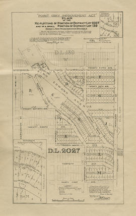
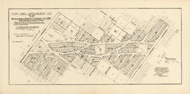
Part is a sheet with two partial sections: one depicting the area bounded by Heather Street to Seventy-second Avenue to Granville Street to the Fraser River; the second depicting the area bounded by Granville Street to Suth-west Marine Drive to Angus Drive to the Fraser River. The maps have been extensively annotated, with colour coded areas to depict land use, status of lots as tax sale properties for sale, sewer and water lines, as well as other colour codes that are not noted on the legend at the front of the volume.
Point Grey section Z supplementary information
Part of City of Vancouver fonds
Part is a sheet showing assessment and other information relevant to Point Grey section Z.

Part of City of Vancouver fonds
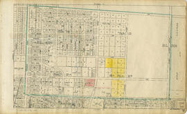
Part is a section depicting the area bounded by Ash Street to Fifty-ninth Avenue to Granville Street to Seventy-first Avenue. The sheet has been extensively annotated, with colour coded areas to depict land use, status of lots as tax sale properties for sale, sewer and water lines, as well as other colour codes that are not noted on the legend at the front of the volume.

Point Grey section X supplementary plans
Part of City of Vancouver fonds
Part is a sheet with supplementary information in the form of a two revised block plans: one for the area bounded by Ash Street to 59th Avenue to Heather Street to 66th Avenue; and the other the bock to the west side of Laurel Street between 64th Avenue and 67th Avenue.

Point Grey section X supplementary information
Part of City of Vancouver fonds
Part is a sheet showing assessment and other information relevant to Point Grey section X.

Part of City of Vancouver fonds
Part is a section depicting the area bounded by Granville Street to Sixtieth Avenue to the east boundary of D.L. 315 to the Fraser River/Seventy-first Avenue. The sheet has been extensively annotated, with colour coded areas to depict land use, status of lots as tax sale properties for sale, sewer and water lines, as well as other colour codes that are not noted on the legend at the front of the volume.

Point Grey section W supplementary information
Part of City of Vancouver fonds
Part is a sheet showing assessment and other information relevant to Point Grey section W. The sheet also includes an added overlay depicting revised block and street plan for the blocks bounded by West Boulevard to 66th Avenue to Angus Drive to Sixty-eighth Avenue (Block 17, D.L. 317).
Part of City of Vancouver fonds
Part is a section depicting the area bounded by Cambie Street to Forty-ninth Avenue to Granville Street to Sixtieth Avenue. The sheet has been extensively annotated, with colour coded areas to depict land use, status of lots as tax sale properties for sale, sewer and water lines, as well as other colour codes that are not noted on the legend at the front of the volume.

Point Grey section U supplementary information
Part of City of Vancouver fonds
Part is a sheet showing assessment and other information relevant to Point Grey section U. The sheet also includes an added overlay depicting revised block plans for the eastern half of the block bounded by Oak Street to 57th Avenue to Hudson Street to Fifty-eighth Avenue (Lot 10, Block 17A, D.L. 526).

Part of City of Vancouver fonds
Part is a section depicting the area bounded by Granville Street to Forty-ninth Avenue to Marine Crescent to Sixty-first Avenue. The sheet has been extensively annotated, with colour coded areas to depict land use, status of lots as tax sale properties for sale, sewer and water lines, as well as other colour codes that are not noted on the legend at the front of the volume.

Point Grey section T supplementary information
Part of City of Vancouver fonds
Part is a sheet showing assessment and other information relevant to Point Grey section T. The sheet also includes an added overlay depicting revised block plans for the area bounded by Arbutus Street to 53rd Avenue to Beechwood Street to 57th Avenue.

Part of City of Vancouver fonds
Part is a section depicting the area bounded by Marine Crescent to Forty-ninth Avenue to Wallace Street to the Fraser River. The sheet has been extensively annotated, with colour coded areas to depict land use, status of lots as tax sale properties for sale, sewer and water lines, as well as other colour codes that are not noted on the legend at the front of the volume.

Point Grey section S supplementary information
Part of City of Vancouver fonds
Part is a sheet showing assessment and other information relevant to Point Grey section S.

Part of City of Vancouver fonds
Part is a section depicting the area bounded by Cambie Street to Thirty-eighth Avenue to Granville Street to Forty-ninth Avenue. The sheet has been extensively annotated, with colour coded areas to depict land use, status of lots as tax sale properties for sale, sewer and water lines, as well as other colour codes that are not noted on the legend at the front of the volume.

Point Grey section Q supplementary information
Part of City of Vancouver fonds
Part is a sheet showing assessment and other information relevant to Point Grey section Q.

Part of City of Vancouver fonds
Part is a section depicting the area bounded by Granville Street to Thirty-seventh Avenue to Trafalgar Street to Forty-ninth Avenue. The sheet has been extensively annotated, with colour coded areas to depict land use, status of lots as tax sale properties for sale, sewer and water lines, as well as other colour codes that are not noted on the legend at the front of the volume.
Point Grey section P supplementary information
Part of City of Vancouver fonds
Part is a sheet showing assessment and other information relevant to Point Grey section P.

Part of City of Vancouver fonds
Part is a section depicting the area bounded by Trafalgar Street to Thirty-eighth Avenue to Wallace Street to Forty-ninth Avenue. The sheet has been extensively annotated, with colour coded areas to depict land use, status of lots as tax sale properties for sale, sewer and water lines, as well as other colour codes that are not noted on the legend at the front of the volume.

Point Grey section O supplementary information
Part of City of Vancouver fonds
Part is a sheet showing assessment and other information relevant to Point Grey section O.

Part of City of Vancouver fonds
Part is a section depicting the area bounded by Wallace Street to Thirty-eighth Avenue to Musqueam Indian Reserve to Forty-ninth Avenue. The sheet has been extensively annotated, with colour coded areas to depict land use, status of lots as tax sale properties for sale, sewer and water lines, as well as other colour codes that are not noted on the legend at the front of the volume.
Point Grey section N supplementary information
Part of City of Vancouver fonds
Part is a sheet showing assessment and other information relevant to Point Grey section N.

Part of City of Vancouver fonds
Part is a section depicting the area bounded by Queen Elizabeth Park to Twenty-seventh Avenue to Granville Street to Thirty-eighth Avenue. The sheet has been extensively annotated, with colour coded areas to depict land use, status of lots as tax sale properties for sale, sewer and water lines, as well as other colour codes that are not noted on the legend at the front of the volume.

Part of City of Vancouver fonds
Part is a section depicting the area bounded by Granville Street to Nanton Avenue to Trafalgar Street to Thirty-eighth Avenue. The sheet has been extensively annotated, with colour coded areas to depict land use, status of lots as tax sale properties for sale, sewer and water lines, as well as other colour codes that are not noted on the legend at the front of the volume.