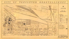
Showing 58 results

Archival description
Vancouver (B.C.) City planning Image With digital objects
Print preview View:

Project 2, area "h" and part of "b" : condition of buildings

Item is a map showing the conditions of buildings (ranging from very good to very poor) in area "a" and part of area "b" in project 2. The map has been annotated to highlite part of the boundary around sub-area 9, as well as the southern portion of the sub-area. The significance of these annotations is not known.

Project 2, area a-2 : condition of buildings

Item is a map showing condition of buildings (ranging from very good to very poor) and sites without buildings in use for storage or parking in the area from Railway Street in the north to Atlantic Street in the south and from Clark Drive in the east to Main Street in the west.

Project 2: identification plan

Item is a map showing city owned property, adjacent lots in same ownership, non-adjacent lots in same ownership, property to be acquired, streets and lanes to be acquired, the boundaries of project 2 clearance, the boundaries of project 1 clearance and the realignment of Raymur Avenue in the area from Railway Street in the north to Atlantic Street in the south and from Clark Drive in the east to Main Steet in the west.

Project 2 : generalized plan of redevelopment

Item is a map showing the boundaries of redevelopment (both "comprehensive" and "limited"), the boundaries of clearance areas for project 1, the boundaries of clearance areas for project 2, the proposed street system and the proposed land use for the city of Vancouver from Burrard Inlet in the north to 16th Avenue in the south and from Nanaimo Street in the east to Arbutus Street in the west.

Project 2, area "h" and part of "b" : plan of redevelopment

Item is a map showing the boundaries of redevelopment areas "b" and "h", the boundaries of project 2 clearance areas 8 and 9, proposed land use, new streets and lanes, easements, sites in project 2 not to be acquired and buildings in project 2 to be retained in the area from Terminal Avenue in the north to Broadway in the south and from Clark Drive in the east to Main Street in the west.

Project 2, area a-2 : proposed property acquisitions project 2

Item is a map showing boundaries of project in area a, property to be acquired, proposed street widening and city owned property included. Annotations show boundaries of project areas, property too be acquired, proposed street widening and properties already owned by the City. Map has been noted as Preliminary.

Results 51 to 58 of 58