![Zoning [and sectional plan of Vancouver] : supplementary information for South Vancouver section ...](/uploads/r/null/2/6/0/2608d0d63481e3c8978db3be443e9b66d7234ec083a47d75000e1ef86da9ef76/4965a245-9306-4c79-b75e-0a261b934ce2-LEG1319_142.jpg)
- COV-S167---: LEG1319.293
- Item
- June 25, 1957-Dec. 23, 1958
Part of City of Vancouver fonds
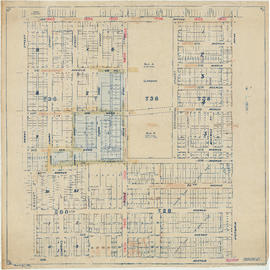
Item contains annotations relating to zoning by-laws depicted on sheet 5 of South Vancouver sectional map.
Part of City of Vancouver fonds
Item contains annotations relating to zoning by-laws depicted on sheet 5 of South Vancouver sectional map.
![Zoning [and sectional plan of Vancouver] : [Bruce Street to Thirty-fifth Avenue to Prince Edward ...](/uploads/r/null/3/d/a/3daa9b206617226e50b095cc8603fdae767b3fc414c195916f05b66e295fdead/4a609b32-6f5b-429b-a5bb-9b2ecef4c865-LEG1319_142.jpg)
Part of City of Vancouver fonds
![Zoning [and sectional plan of Vancouver] : [St. George Street to Forty-seventh Avenue to Cambie S...](/uploads/r/null/3/9/4/3941a4fe4a112dc53ad93bb5a5ef103cf034b473debbf376f05d2c3d456dabdb/1db7e5aa-a53b-4bbc-9651-21067e7a026b-LEG1319_142.jpg)
Part of City of Vancouver fonds
![Zoning [and sectional plan of Vancouver] : [St. George Street to Fifty-eighth Avenue to Ash Stree...](/uploads/r/null/f/d/0/fd040366ef532467eded717fb492810507a7765ff1aebea743bdea53ff5c99b5/9e11c01b-096c-4c73-9e56-7dd0ece8a85f-LEG1319_142.jpg)
Part of City of Vancouver fonds
![Zoning [and sectional plan of Vancouver] : [Boundary Road to Fiftieth Avenue to Raleigh Street to...](/uploads/r/null/6/5/b/65bbd9f1763982aae0e8cc3f391040ca152c3d54f827b433660452db2f46cca2/70572df7-147c-4c2f-bdca-d1a4411454cf-LEG1319_142.jpg)
Part of City of Vancouver fonds
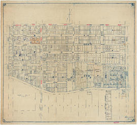
Item is a map showing the area located north of sheet 18.
![Zoning [and sectional plan of Vancouver] : [Boundary Road to Sixty-fifth Avenue to Vivian Street ...](/uploads/r/null/1/e/3/1e30fdaa9b73eb9bd49b193a7ebb4665b5ba524b0f8f82e32afcdfb2190b2d1b/64a6753d-caf0-4726-8c27-21e998252b68-LEG1319_142.jpg)
Part of City of Vancouver fonds
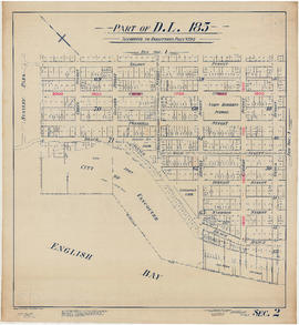
Part of D.L. 185 (Vancouver section 2)
Part of City of Vancouver fonds
Item is a sectional plan showing the area bounded by Nicola Street to Nelson Street to Chilco Street to Beach Avenue.
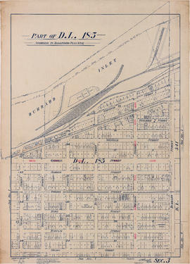
Part of D.L. 185 (Vancouver section 3)
Part of City of Vancouver fonds
Item is a section plan which shows the area bounded by Burrard Street to Pender Street to Nicola Street to Nelson Street.

Part of D.L. 185 (Vancouver section 4)
Part of City of Vancouver fonds
Item is a sectional plan which shows the area bounded by Burrard Street to Beach Avenue to Nicola Street to False Creek.

Sectional map. City of Vancouver, B.C. Sheet no. C.V. 9
Part of City of Vancouver fonds
Item is a sectional plan which shows the are bounded by Scott Street/Heatley Street to Union Street to D.L. 2037 Lot B to Seventh Avenue. The map includes the Canadian National Railway and Great Northern Railway depots and electric street car lines.
General plan - sheet 9 (Point Grey)
Part of City of Vancouver fonds
Item is a sectional plan which shows the area bounded by Arbutus Street to Forty-seventh Avenue to Musqueam Reserve to Fifty-third Avenue. The map includes a section of the Musqueam Indian Reserve, as well as the Lulu Island electric street car line.

General plan - sheet 19 (Point Grey)
Part of City of Vancouver fonds
Item is a sectional plan which shows the area bounded by Ash Street to Fifty-ninth Avenue to Arbutus Street to Sixty-seventh Avenue. The map includes the electric streetcar line.
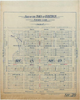
Part of the town of Hastings. Suburban lands (section 20)
Part of City of Vancouver fonds
Item is a sectional plan which shows the area bounded by Rupert Street to Twenty-second Avenue to Renfrew Street to Twenty-ninth Avenue.

Part of City of Vancouver fonds
Item is a sectional plan which shows the area bounded by Nanaimo Street to 16th Avenue to Commercial Drive to 27th Avenue. The map includes Trout Lake.

Sectional map City of Vancouver, B.C. sheet no. S.V. 7
Part of City of Vancouver fonds
Item is a sectional plan which shows the area bounded by Duchess Street to Twenty-seventh Avenue to Victoria Drive to Thirty-fourth Avenue.

Part of City of Vancouver fonds
Item is a sectional plan which shows the area bounded by Knight Street to 33rd Avenue to Fraser Street to 41st Avenue.

Part of City of Vancouver fonds
Item is a sectional plan which shows the area bounded by Victoria Drive to 41st Avenue to Knight Street to 49th Avenue.
Part of City of Vancouver fonds
Item is a sectional plan which shows the area bounded by Victoria Drive to 49th Avenue to Knight Street to 59th Avenue.
Part of City of Vancouver fonds
Item is a sectional plan which shows the area bounded by Fraser Street to 59th Avenue to Ontario Street to South-east Marine Drive. The map includes former street names and large parcels of land south of Marine Drive.

Part of City of Vancouver fonds
Item is a sectional plan which shows the area bounded by Ontario Street to 59th Avenue to Ash Street to 70th Avenue.

Part of City of Vancouver fonds
Item is a sectional plan which shows the area bounded by Knight Street to 59th Avenue to Fraser Street to the Fraser River. The map includes the Vancouver and Lulu Island railway line (Kent Road), proposed lease line to Western Plywood and large parcels of land at the shore line.
![General plan - sheet 2 [Alma Street to Second Avenue to Drummond Drive to Ninth Avenue]](/uploads/r/null/6/a/a/6aa9ab32dffb6bed1b9bc97d3109370e314fa8e7d9f87ce5916594c06a11b6a8/566584a0-44bd-41c3-8c99-fcc6794b6c75-LEG1153_142.jpg)
General plan - sheet 2 [Alma Street to Second Avenue to Drummond Drive to Ninth Avenue]
Part of City of Vancouver fonds

Part of City of Vancouver fonds
600 West Pender Street south side
Part of City of Vancouver fonds

500 Granville Street east side
Part of City of Vancouver fonds

Part of City of Vancouver fonds

700 Granville Street east side
Part of City of Vancouver fonds
Part of City of Vancouver fonds
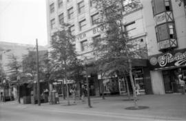
Image shows Vancouver Block and Phantasmagoria.
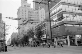
700 Granville Street east side
Part of City of Vancouver fonds
Image shows Royal Bank of Canada.

Part of City of Vancouver fonds
Image shows U-Frame-It Ltd.

Part of City of Vancouver fonds

Part of City of Vancouver fonds

Part of City of Vancouver fonds
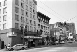
1000 Granville Street east side
Part of City of Vancouver fonds
Image shows Regal Hotel.
1000 Granville Street east side
Part of City of Vancouver fonds

600 Helmcken Street north side
Part of City of Vancouver fonds

Part of City of Vancouver fonds
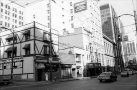
Image shows Blackstone Hotel [previously the Hotel Martinique].

1100 Granville Street east side
Part of City of Vancouver fonds
Image shows Blackstone Hotel and the Bank of Nova Scotia.

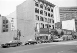
Part of City of Vancouver fonds
Image shows Fane's Ltd.

Part of City of Vancouver fonds

1300 Granville Street east side
Part of City of Vancouver fonds

Part of City of Vancouver fonds
Images show Sears.

500 Dunsmuir Street north side
Part of City of Vancouver fonds
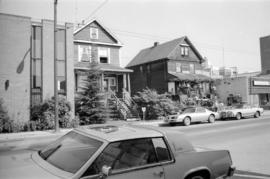
Part of City of Vancouver fonds

500 Dunsmuir Street south side
Part of City of Vancouver fonds
Image shows Salvation Army Dunsmuir House for Men.

Part of City of Vancouver fonds
Image shows Teddy's Cafe.

Part of City of Vancouver fonds
Part of City of Vancouver fonds

Part of City of Vancouver fonds

Part of City of Vancouver fonds