First Narrows, Burrard Inlet, B.C. showing Parthia and Burnaby shoals
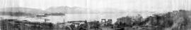
[360 degree view of Vancouver from the roof of the second Hotel Vancouver]
Coal Harbor Vancouver. Height of Water In Upper End 9 ft. above. Zero
[Northeast view of downtown Vancouver from the roof of the Hotel Vancouver]
Vancouver Harbour
[View of Burrard Inlet from Point Grey]
[View of Burrard Inlet toward Howe Sound from Point Grey]
Vancouver Harbour
Vancouver Harbour
[Northern view of downtown Vancouver from World Building, 500 Beatty Street]
[View of water front showing the C.P.R. station and yard and Pier D under construction]
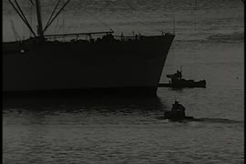
[View of ship in Coal Harbour and Deadman's Island, from foot of Bute Street]
[View of Coal Harbour, Deadmans Island, and North Shore mountains from foot of Thurlow Street]
[View of Coal Harbour, Deadman's Island, part of Stanley Park, and the North Shore mountains, from John Morton's clearing at the foot of Thurlow Street]
[View of Coal Harbour, Deadman's Island, part of Stanley Park, and the North Shore mountains from the foot of Bute Street]
[View of Victoria, B.C., from the Parliament Buildings, showing James Bay Bridge and surrounding buildings]
[View of Victoria, B.C., from the Parliament Buildings, showing the inner harbour]
[View of Victoria, B.C., from the Parliament Buildings]
[Dock and boats in Esquimalt harbour]
[Rowboats in harbour for regatta]
[Rowboats in harbour for regatta]
[Rowboats in harbour for regatta]
[View of clearing at foot of Burrard Street, showing ships in harbour]
[View of Pender Street between Burrard and Thurlow Streets, showing ships in harbour]
[View of Pender Street between Burrard and Thurlow Streets, showing houses and ships in harbour]
[Sailors rowing to shore from the H.M.S. "Amphion" in Vancouver harbour]
[Coal Harbour?]
[Coal Harbour?]
[Coal Harbour?]
[Coal Harbour?]
[Coal Harbour?]
[Coal Harbour]
[Coal Harbour]
[Coal Harbour view from Denman Street]
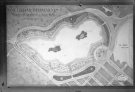
Coal Harbour Improvements Suggested Treatment of Inner Basin
[English Bay after heavy snowfall]
Port Arthur, Ont., from harbor
Port Arthur, Ont., showing Thunder Bay
City from Stanley Park, and first gasoline service station. Imperial Oil Limited.
City and Deadman's Island near Nine 0'Clock Gun
Brockton Point looking east
[Aerial view of Vancouver Harbour looking east from Lost Lagoon]
[Native Indian canoe races in Inner Harbour, Victoria]
[View of Victoria waterfront, showing post office and boats in inner harbour]
![Burrard Viaduct Construction [2 of 10]](/uploads/r/null/5/7/57426101abc66a2ab407c951565e28bb07f8f27238a35bb05d7478ded4e540b1/8b87415b-c4bc-4c5c-bf5c-89e3546722c2-A66653_142.jpg)
![Burrard Viaduct Construction [1 of 10]](/uploads/r/null/2/7/2788a9638050d7cbfc021e29977d956f423fe6048bb7c29c035ea57bda6dd66c/5df17b4f-3ebf-4f8d-ac21-de11bd89033f-A66652_142.jpg)


![[360 degree view of Vancouver from the roof of the second Hotel Vancouver]](/uploads/r/null/7/2/72f205b48502a927912ec46b74aa571f102f387013c2d6bce557a2420fd72aa7/269934f7-d517-4c58-b633-4167772f935b-A63168_142.jpg)

![[Northeast view of downtown Vancouver from the roof of the Hotel Vancouver]](/uploads/r/null/d/e/de95d099d1517793665187336820ebdb65db9f066b651b935a78788383053fb3/5b49058f-4381-43c8-b28f-9755248fa953-A63006_142.jpg)
![[View of Burrard Inlet from Point Grey]](/uploads/r/null/e/3/e320d8072b352225b343a6bf036a24dfbe3d1f2d722001dd0b12d0aa899d36bb/bb12fe87-3475-4839-9e59-891393008d05-A64782_142.jpg)
![[View of Burrard Inlet toward Howe Sound from Point Grey]](/uploads/r/null/d/7/d70841724af53c279a31c140bbc1fce42a0aa6a1d3a9c40cff087f263ccc345d/7095bde6-1c57-4e91-b87a-60bb6b7cd9f3-A64735_142.jpg)


![[Northern view of downtown Vancouver from World Building, 500 Beatty Street]](/uploads/r/null/9/9/997cc0ffa3d5b19d17a58c9f16a1c6f9855c9019e5f3249c78d456803ea58779/b52f219d-f015-40b1-96a6-c089ab3c8d70-A63175_142.jpg)
![[View of water front showing the C.P.R. station and yard and Pier D under construction]](/uploads/r/null/2/7/2781b7cdfb12c9119a5fca39a4be76488e2a9adc05038f861af4810c250356bf/2ca5a454-46e7-41c1-84fb-580e4bc03252-A63185_142.jpg)
![[View of ship in Coal Harbour and Deadman's Island, from foot of Bute Street]](/uploads/r/null/c/a/ca08065478426138b96322562f2e229721e66f75053f6ef16a6f73c655815bf9/e78cbbbf-fc54-4725-a7a8-7bbee9ee0162-A07648_142.jpg)
![[View of Coal Harbour, Deadmans Island, and North Shore mountains from foot of Thurlow Street]](/uploads/r/null/4/c/4ce8248f3e2c6a40b98fe6815778e930d730e9bc6fef96c61b3f9f0715075431/ed4d630a-fcce-461f-aaaa-3bab818f9bc6-A07647_142.jpg)


![[View of Victoria, B.C., from the Parliament Buildings, showing the inner harbour]](/uploads/r/null/8/f/8f5ba1a3dcfb32b47cad5fbbc77aa653e2fe8c099588b8474ff8155d773baa05/ad4e4250-3066-40b2-859d-74097692651a-A07654_142.jpg)
![[View of Victoria, B.C., from the Parliament Buildings]](/uploads/r/null/2/5/25b93cd5368b86d92ffa8dea30a9aae210661abc2c05e903a2c0d24dd47158b2/a4f5e146-cd11-44c9-af08-dffe28bbc8dc-A07653_142.jpg)
![[Dock and boats in Esquimalt harbour]](/uploads/r/null/0/e/0e25442aad79db6eaeeaaa96cb15d95efbbfa07cfa78b61916338d055010bac7/4cdf1f29-4665-4203-b3ee-0bc8988719f3-A07650_142.jpg)
![[Rowboats in harbour for regatta]](/uploads/r/null/0/d/0debb603b15a961c88309aaea8f43a2a6071bc64a914c4d177f25725d819bf71/f245e588-08f5-44ff-866e-2aa5791bb9c5-A07612_142.jpg)
![[Rowboats in harbour for regatta]](/uploads/r/null/9/d/9d458757030e0adf87d4850d9f3f4fc08b05bd5f17091a77b867ead298e8110e/dc3b04e5-0d4d-4ef6-b733-b8b52c8fcbef-A07610_142.jpg)
![[Rowboats in harbour for regatta]](/uploads/r/null/c/c/cc6de5eac46bac119c80428ac7b02ed401de255fc62ef6a89d136494921240de/fc5264d2-3ab8-4a84-9dcd-bdeb27fc0afd-A07608_142.jpg)
![[View of clearing at foot of Burrard Street, showing ships in harbour]](/uploads/r/null/7/8/78b3af6cd868bbad006ed34e13d07aa777902e54bdd3decb808046646b9b01a3/842ea67f-73eb-447a-adf2-428d6245779a-A07604_142.jpg)
![[View of Pender Street between Burrard and Thurlow Streets, showing ships in harbour]](/uploads/r/null/7/8/78e5ebf660d4be04085232c4df48a55b2f53fc69b8b24917d11a327c279b273e/238ef5af-164f-4608-b421-7f1ea11419d7-A07605_142.jpg)
![[View of Pender Street between Burrard and Thurlow Streets, showing houses and ships in harbour]](/uploads/r/null/f/0/f00ac5f1f323bcee985db1f23354ad1a01e377075c05ff005e8291cfa6ea59bb/257c6f06-9e48-4b7a-8964-00daf6a2493f-A07603_142.jpg)
![[Sailors rowing to shore from the H.M.S. "Amphion" in Vancouver harbour]](/uploads/r/null/9/b/9bfc3c89bfb227c2ed0b8630533f99722a1277d24cb1e70d34c7740bb5438220/9d00534a-5cfe-42bf-819c-c9fceb9dbf60-A07602_142.jpg)
![[Coal Harbour?]](/uploads/r/null/1/0/10b1e3b62444e17b20e5c87b9cb37773568bcad1eb9f6ef2efd8c228b7f06408/5aa04f62-7a7b-4a73-a8bf-7920b9573446-A16631_142.jpg)
![[Coal Harbour?]](/uploads/r/null/f/b/fb269570031b2a3828f329c97b9db78a5236f47cf4286fb78bf3c2058c53b0de/626b353c-ab4a-4c40-bcaf-41aaec70fe04-A16630_142.jpg)
![[Coal Harbour?]](/uploads/r/null/1/c/1c43ca1c74017572cccbbeb20b07dae64a1d3dc2d6ed6573e3555df279535121/dee93f4d-4cde-4f0b-b504-dfb863bfa77d-A16629_142.jpg)
![[Coal Harbour?]](/uploads/r/null/d/b/db2de6c93437b31527635deddfa2d1b0228f1dfd0d78c0bf6d754fd685fc663b/dccf9129-e23d-46e6-8e3f-0adde1d833b8-A16628_142.jpg)
![[Coal Harbour?]](/uploads/r/null/b/4/b488b986b859b20d49e5b4d6f59cb320223b0da4668774c67790e46f15e737a7/ea0b239a-5c45-449d-80f0-04a4483b3cd5-A16627_142.jpg)
![[Coal Harbour]](/uploads/r/null/8/3/83bd003a993aaa90a0c6aea33d3521bf9163833f067d66579783658045125695/447583bd-7a62-4edd-9558-f0bcaf009c90-A16626_142.jpg)
![[Coal Harbour]](/uploads/r/null/e/6/e641a81bbc0d7d8adfb51e6e32ecb57659f5dccdce517fb88dd14160144e3e52/c67b13d2-e877-4fb3-8b2f-0de875c9280a-A16625_142.jpg)
![[Coal Harbour view from Denman Street]](/uploads/r/null/f/4/f4ee6b5b8d147b8a774a97a7b59f6f8c29bb8792a52da1695f47dce307742555/f90773a4-4b21-478d-bd42-505e1d441b47-A16624_142.jpg)
![[English Bay after heavy snowfall]](/uploads/r/null/9/8/98d57e6aa43d81b764d660589019a9777086ef8ffa1ac5d9463a527dee1dbf26/46e3a80b-3931-459d-9c09-b1bd42694079-A16571_142.jpg)


![[Aerial view of Vancouver Harbour looking east from Lost Lagoon]](/uploads/r/null/a/7/a7c598133f7f2c78a6bb65602262bc193ceb787389db5cd31ded3868025265ca/72eb674f-7c20-4ecc-a618-3a1e88e660c8-A62798_142.jpg)
![[Native Indian canoe races in Inner Harbour, Victoria]](/uploads/r/null/0/b/0bda6af6044a499cb77794faa4697c0d3b543bfdb67d3fcfbefc6fb24c0058d4/e732393e-bed4-45e2-955a-ad84e9fa5cd0-A04498_142.jpg)
![[View of Victoria waterfront, showing post office and boats in inner harbour]](/uploads/r/null/f/5/f551525fa2d75fd073c1705b8b964a3c8ca0158646f41313216ae6dac1b20b42/50c336b1-8bdc-428c-91f1-4b9fdf8fdf0e-A04349_142.jpg)
![[Parliament Buildings, Victoria, B.C.]](/uploads/r/null/d/0/d0f3827fcba74f71918e13419e6a10f2abbb53aad9ccd3b6e764a59a8e42e0d6/58091dda-eca1-43d9-83d4-2ad2d2a77bb5-A04350_142.jpg)