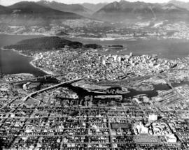
![[Aerial view of Vancouver looking northeast]](/uploads/r/null/e/b/eb04990a1e0714b74de255da43c9b8ae6f6f52e23bbf3735f707b20d0463fbe0/b9785bd2-0b41-4ed0-9f20-b5faf38aaf2f-A23478_142.jpg)
[Aerial view of Vancouver looking northeast]
- AM54-S4-: Air P81.1
- Item
- 1956
Part of Major Matthews collection
Photograph shows Kits Point, Kitsilano, Downtown, West End, False Creek, Burrard Bridge and the Granville (Street) Bridge.
462 results with digital objects Show results with digital objects
[Aerial view of Vancouver looking northeast]
Part of Major Matthews collection
Photograph shows Kits Point, Kitsilano, Downtown, West End, False Creek, Burrard Bridge and the Granville (Street) Bridge.
![[Aerial view of Vancouver looking east]](/uploads/r/null/9/3/93309104da24ef0ea4391055c01c783c88d8d52c9939ee604b894d907555df68/564df6c6-3fbe-40b9-bba9-6386ae62ff3c-A23479_142.jpg)
[Aerial view of Vancouver looking east]
Part of Major Matthews collection
Photograph shows the waterfront along Burrard Inlet, Downtown, West End, Pender Street, West Georgia Street and Robson Street.
![[Aerial view of Kitsilano looking east over Kitsilano Beach]](/uploads/r/null/d/e/de9aa8187efba90164a4908026214320fff2d9978653d3f44f938fe4d88186b9/58cc6c82-2e2f-4948-9fa1-ba29c7edbea5-A23480_142.jpg)
[Aerial view of Kitsilano looking east over Kitsilano Beach]
Part of Major Matthews collection
Photograph shows Kitsilano Park and the Kitsilano Swimming pool.
![[Aerial survey view of First Narrows, Stanley Park, the West End, Downtown and North Vancouver]](/uploads/r/null/f/8/f875c0a639388b4936ef86faafb227a0fcad6478409cc8c2ff64fa2c06296ca5/94a6f99f-1ce3-4c9b-9e48-894735d096e9-A23486_142.jpg)
[Aerial survey view of First Narrows, Stanley Park, the West End, Downtown and North Vancouver]
Part of Major Matthews collection
Perpendicular view (mosaic)

Part of Major Matthews collection
Oblique view. Photograph shows Queen Elizabeth Park, Little Mountain Reservior, the quarry and Little Mountain Housing Project.
![[Northeast aerial view of Burrard Inlet and Vancouver]](/uploads/r/null/6/6/662502a43d6839b8b0b3518a2f22ca5822fc6dc224c73d5002c705655d5ab329/48aa6304-734e-41ed-8ef2-daffdac1a38d-A23488_142.jpg)
[Northeast aerial view of Burrard Inlet and Vancouver]
Part of Major Matthews collection
Oblique view
![[Aerial view of] English Bay Beach [the West End and Coal Harbour]](/uploads/r/null/b/b/bb7c88b9152ef2f0cd0c703a1f4b8ec3bb0049756fc1b2866fca72704a96421a/73ce5f2f-8ac1-4465-aa81-d5454e7356bb-A23489_142.jpg)
[Aerial view of] English Bay Beach [the West End and Coal Harbour]
Part of Major Matthews collection
Oblique view. Photograph shows apartment buildings west of Denman Street.
![[View of Georgia Street looking east from Broughton Street]](/uploads/r/null/b/3/b36a0ffb562445ab07907f340f899fb198d3da341503d87325ba6f798192024b/5888eb3d-0b22-4147-b01a-3a4f70ddb45c-A23490_142.jpg)
[View of Georgia Street looking east from Broughton Street]
Part of Major Matthews collection
Photograph shows Clarke Simpkins car dealership (1300 block West Georgia), Felix Apartments (610 Jervis Street), Lancaster Apartments (621 Jervis), Imperial Oil Building (1281 West Georgia), and the Rixon Court Apartments and Coffee Shop (720 Jervis Street)
![[Aerial view of Vancouver looking north]](/uploads/r/null/b/3/b3d3a0fbaf13d79ee1e9bda0902e11d0e4c0033f87fcfd48b7229bb32680e9e4/050796c7-0567-497d-b620-32f8958cbfb9-A23491_142.jpg)
[Aerial view of Vancouver looking north]
Part of Major Matthews collection
Oblique view. Photograph shows Fairview R.C.A.F. Equipment Depot, False Creek, Burrard Bridge, C.P.R. Kitsilano Trestle, Granville (Street) Bridge, Granville Island, the West End, Downtown and Burrard Inlet.
![[Aerial view of Downtown looking west from Granville Street]](/uploads/r/null/1/0/10903c6f6eb76e95eb8087a1b33bce6b998145848d5cee0ac237f1c676b77644/7cecb0f6-a946-4166-8861-9f447cb59be7-A23492_142.jpg)
[Aerial view of Downtown looking west from Granville Street]
Part of Major Matthews collection
Oblique view. Photograph shows Court house building and grounds, Hotel Vancouver, Georgia Medical Dental Building, Vancouver Public Library and Coal Harbour.

Part of Major Matthews collection
Oblique view. Photograph shows Coal Harbour, H.M.S.C. Discovery, Royal Vancouver Yacht Club marina, Rowing Club marina, Brockton Oval and the Burrard Inlet waterfront.

Part of Major Matthews collection
Vancouver from the air looking north from over Little Mountain
Part of Major Matthews collection
Oblique view. Photograph shows Fairview, False Creek, R.C.A.F. Equipment Depot, Granville Island, Burrard Bridge, Granville (Street) Bridge, Downtown, West End, Stanley Park, Vancouver General Hospital, First Narrows and Burrard Inlet.
![[Aerial view of Kitsilano Beach]](/uploads/r/null/0/4/04933fd0b52b1825a12ac427f70fb35dc469232064c8156168d851093d1ae411/05361ecf-adfc-4cdc-be95-07157d2e9dd1-A23610_142.jpg)
[Aerial view of Kitsilano Beach]
Part of Major Matthews collection
Oblique view.
![[Collapse of Second Narrows bridge during construction]](/uploads/r/null/7/b/7b1b0ec0cf16f91f2f421656c37e2edaa449477a299e7b2ac3df0109763f7707/a9342f72-46ec-44d5-bf84-fde7dc22a42a-A24446_142.jpg)
[Collapse of Second Narrows bridge during construction]
Part of Major Matthews collection
Oblique view.
![[Aerial photograph of the Alberta Wheat Pool elevators and shipping gallery]](/uploads/r/null/3/2/32dabc19b9a47ef8b896d54d0659490566097669fc4b47d2f53556b539abddda/989f5b86-0587-4af2-9362-01b4eea2b5d7-A25116_142.jpg)
[Aerial photograph of the Alberta Wheat Pool elevators and shipping gallery]
Part of Major Matthews collection
Oblique view shows the New Brighton Pool
![Race Track - [Hastings] Park](/uploads/r/null/a/e/ae3866984dbd71adb11e4f16a3faeff5c926d7d6dbc7c68bef37bbe9e34f2147/8e72031a-2c43-4d2f-ade2-eaf99cf53105-A44678_142.jpg)
Part of Stuart Thomson fonds
Oblique view showing a view looking southeast along Renfrew Street towards Hastings Street, parts of Wall Street, Trinity Street and McGill Street, the northern section of Hastings Park, the roller coaster, the Manufacturing/Industrial Building and the Exhibition Building on the Exhibition Grounds. The photograph also shows a house at 2950 Trinity Street.
![Grain Elevators and dock - foot of [Commercial] Drive looking east](/uploads/r/null/f/a/fa64fc2fdcd81147912c6227ac42be08f398a362ba801186b73930b6b55d9888/5fb3ff66-892d-4cce-b810-d6918a9c1aed-A44690_142.jpg)
Grain Elevators and dock - foot of [Commercial] Drive looking east
Part of Stuart Thomson fonds
Oblique view showing the Canadian Government Elevator and dock

Looking East showing Second Narrows and North Arm of Burrard (South Shore of Inlet - Hastings East)
Part of Stuart Thomson fonds
Oblique view showing sawmills
View of Kitsilano and False Creek
Part of Stuart Thomson fonds
Oblique view showing Kitsilano Beach, the Kitsilano Trestle and Granville Bridges and Granville Island, the West End and Downtown in the background

Part of Stuart Thomson fonds
Oblique view looking east along Broadway showing Kitsilano, the B.C.E.R. Lulu Island line, and the Kitsilano Trestle and Granville Bridges, Granville Island, Fairview, Downtown and Yaletown in the background

Looking East Along Georgia Street
Part of Stuart Thomson fonds
Oblique view showing Pacific Coast Lumber, boat builders at the foot of Bidwell Street, the West End east of Denman Street and the second Hotel Vancouver and Downtown in the background

Showing Entrance to Stanley Park looking East
Part of Stuart Thomson fonds
Oblique view showing Lost Lagoon, Coal Harbour, Deadman's Island, Brockton Point, Denman Arena, the Horseshow Building and Downtown in the background

Prospect Point Showing West Vancouver Ferry in Narrows
Part of Stuart Thomson fonds
Oblique view showing the lighthouse
![[View of farm buildings and fields taken from the air]](/uploads/r/null/9/b/9b1f700b1bdee44fb2534cdd56a164987f3e8bb21e6f247ae7822623a2df94dc/7d25fb85-64f0-4eca-a154-b9f6d0bc65bf-A13721_142.jpg)
[View of farm buildings and fields taken from the air]
![[Aerial view of Vancouver]](/uploads/r/null/7/0/70fe55216d34bcc4ff4f671e2d7814e6d15c21dd5aaf76b58bc6469a40388a1d/c25263bf-0975-439c-bc93-248713d79567-A13722_142.jpg)
![[Aerial view of Vancouver showing the Fraser River]](/uploads/r/null/d/b/db0369bf59a848e9764e3b839c47c8ec7201f99a4017bbddd8512f47ca26200f/5ab47fec-a8ce-4ad4-a81e-ae2c39689e5a-A13723_142.jpg)
[Aerial view of Vancouver showing the Fraser River]
![[View of the Goodyear blimp taken from an airplane above Vancouver]](/uploads/r/null/3/3/3336881308e1e37de96b9ef201f813bbbd6e2db7aa1821f78400ef5a8deb32ff/5b651868-2938-4420-a791-777473cdb6e8-A13724_142.jpg)
[View of the Goodyear blimp taken from an airplane above Vancouver]
![[Aerial view of Vancouver]](/uploads/r/null/d/7/d7f280a1021ddedf2aae71722e35fd9ee91a1e6d3f2e31003eed6fec146e27e7/e30c0e8a-964a-484e-90db-349ad9165b2f-A13725_142.jpg)
![[Aerial view of Vancouver]](/uploads/r/null/b/6/b61e5089ec8edb824f16eea9b4373dfb3ac9ea83b052f855a90859c3a7424f4c/c7a56b73-012c-4e6d-b4e3-c362735e3a05-A13726_142.jpg)
![[Aerial view of Vancouver showing the Goodyear blimp]](/uploads/r/null/8/e/8e555d9af3baf3296446345ad718a4b310d778d587429ac7d783ddf6d0bd1a28/11f7d743-9030-4973-aec6-c44fd5ba4e7c-A13727_142.jpg)
[Aerial view of Vancouver showing the Goodyear blimp]
![[Aerial view of Vancouver showing the Goodyear blimp above the Downtown area]](/uploads/r/null/8/4/845b713451cd89bf22d1340d07a741cc7c4b68ce884237a8bf7db719fb1f8a0c/f7115108-1cb7-4a7e-b6f7-b767fbd53e1d-A13728_142.jpg)
[Aerial view of Vancouver showing the Goodyear blimp above the Downtown area]
![[Aerial view of Vancouver]](/uploads/r/null/b/4/b48d4b96f8547ec1a2bf06286a2cb6ded5510700d395242e2bcb283c884cdcc0/3730cb73-0bef-4e47-843a-9953c8d8e913-A13729_142.jpg)
![[Aerial view of Vancouver showing the Goodyear blimp]](/uploads/r/null/a/d/ad5d6048618bc821a9d06934fa1761a7e251dafba8693dc6f459758258ed169f/ffc49cb9-3d17-409a-b2a2-f9c574508d81-A13730_142.jpg)
[Aerial view of Vancouver showing the Goodyear blimp]
![[Aerial view of Vancouver showing CPR piers, Coal Harbour, and Stanley Park]](/uploads/r/null/8/2/82143d16653193252b06da622f500eff3170f5e7e984e78ebfaf6f92255a4522/68bb2619-41d4-40a4-bce2-8562cad89b9e-A13731_142.jpg)
[Aerial view of Vancouver showing CPR piers, Coal Harbour, and Stanley Park]
![[Aerial view of piers in Coal Harbour and part of downtown Vancouver]](/uploads/r/null/3/d/3dea4ff428030ca6b9c2fedd905fb85bdb6565d2e128563bae589050d4b0f133/2cddd923-ab3c-4a2c-be2b-fd929084db11-A13732_142.jpg)
[Aerial view of piers in Coal Harbour and part of downtown Vancouver]
![[Aerial view of downtown Vancouver]](/uploads/r/null/9/5/953f0d3ea8e3ecbb55e2210d94ead53f5be11ac38f8801476c6f0a576bc5953d/f265a01b-d073-47c0-99e1-e2832c475ddb-A13733_142.jpg)
[Aerial view of downtown Vancouver]
![[Aerial view of Vancouver showing piers along the waterfront looking east]](/uploads/r/null/d/4/d4bb5ecff1c03cb6c58a6b9e983755d30fc68d1f35ccda97bbc0817e3cd99e96/8729b350-60b7-4857-97ca-7ce5014b9d0c-A13902_142.jpg)
[Aerial view of Vancouver showing piers along the waterfront looking east]

Aerial view of three bridges at Second Narrows
Part of Vancouver Express fonds
Item is a photograph showing an aerial view of three bridges at Second Narrows. Caption from Vancouver Express: "Three bridges at Second Narrows will soon be down to two as old structure (centre) is slated for demolition. Rail traffic which once used old bridge now travels over CN rail bridge which was completed last year. Aerial photo was taken from Harrison Airways Cessna 172, piloted by Hugh Fraser."

Aerial view of Vancouver city centre looking east
Part of Vancouver Express fonds

Aerial view of Vancouver city centre showing waterfront to the east
Part of Vancouver Express fonds
Item is a photograph showing an aerial view of Vancouver city centre with waterfront to the east. Photo was taken from Harrison Airways Cessna I72 piloted by Hugh Fraser.

Aerial view of Vancouver harbour towards Second Narrows
Part of Vancouver Express fonds
![[Aerial view of Vancouver]](/uploads/r/null/9/b/9b3acec26123edc53f11bf2f41f3286d09254ffea9918cd31b6715395ebe18d0/26473909-fe49-4474-8c3f-05eb1e8ab059-CVA1376-252_142.jpg)
Oblique view showing Fairview, Vancouver General Hospital, False Creek and the Expo 86 and other sites under development on the north side, Granville Island, Granville Bridge, Burrard Bridge, Yaletown, Downtown, the West End, Stanley Park and the Lions Gate Bridge, North Vancouver and The Lions in the background
![[Aerial view of fire at Vancouver sawmill]](/uploads/r/null/2/6/261c182ef20aa4aa00d0b46917096bf17c339730ec5975e81a6c1fbc2b63158f/05be5137-bdbf-42ad-a142-3e73d5538015-A71287_142.jpg)
![[R.C.A.F. Maritime Air Command plane No. 102 flying over English Bay]](/uploads/r/null/1/3/13b6c7a118ed10801cfbe633df28806771f06f62a484edbf5de83c5acd20e0a4/ff8af309-b1af-4c30-9216-ba8a2859660d-A71302_142.jpg)
[R.C.A.F. Maritime Air Command plane No. 102 flying over English Bay]
Oblique view showing the Vancouver Maritime Museum and Kits Point residences in the foreground, and the West End, Downtown, Stanley Park and Burrard Inlet in the background.
![[Aerial photograph of downtown Vancouver looking north]](/uploads/r/null/2/4/24032a0f19bc217e5bb533d7218824f932301e972f1020a352118b50afcf8a93/8e2450db-6794-4283-95a6-7641bc80437d-A69847_142.jpg)
[Aerial photograph of downtown Vancouver looking north]
Photograph shows an oblique view of the north shore of False Creek including the C.P.R. Roundhouse, Yaletown, Cambie Bridge (old), Sweeney Cooperage, Georgia Viaduct, Post Office building under construction, Pier "B/C", Coal Harbour, Stanley Park, Lions Gate Bridge and a view of North and West Vancouver.
![[Aerial view of Downtown Vancouver looking south from Burrard Inlet]](/uploads/r/null/3/2/32bc12be65a895f144d669768ee019e6abc83bc4018b11b3ecf96930fbd98786/024e645a-ce5d-4e73-a4e1-efb2ad9b7995-A71518_142.jpg)
[Aerial view of Downtown Vancouver looking south from Burrard Inlet]
Photograph shows Canada Place under construction, the SeaBus terminal, Waterfront Station (formerly the C.P.R. Station), the Marine Building, Harbour Centre and False Creek and Granville Island in the background
![[Aerial view of rail yard and industrial area]](/uploads/r/null/9/f/9f92989deb2b54597c6743bd67717653fc644c23b6fc48e55d2e1b9dbf6e8489/763b5a38-9eae-4b16-bedc-45ca5c32d888-A71602_142.jpg)
![[Aerial view of industrial area]](/uploads/r/null/5/d/5dd69372e15c5f349b4b4b8cdb7a12063cbbf02d158ab97d57ba863214b5c209/5f3baa69-a2f9-4adb-a590-4b420086d51d-A71604_142.jpg)
Item is aerial view from downtown Vancouver showing Coal Harbour, Deadman's Island and the North Shore Mountains.