British Columbia - Vancouver skyline
- AM1435-: CVA 1435-38
- Item
- [197-?]
Item is aerial photograph of Stanley Park and Coal Harbour.
447 results with digital objects Show results with digital objects
British Columbia - Vancouver skyline
Item is aerial photograph of Stanley Park and Coal Harbour.

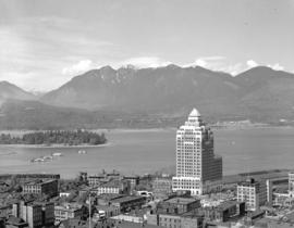
British Columbia - Vancouver skyline
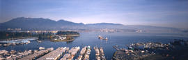
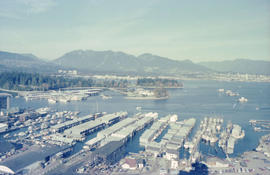
Item is aerial photograph showing a panoramic view of downtown Vancouver looking north west towards Stanley Park and Coal Harbour.

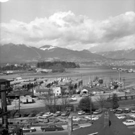
British Columbia - Vancouver skyline
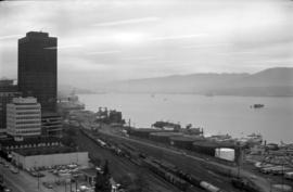
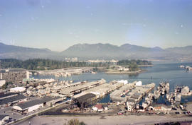
Item is photograph showing downtown Vancouver looking north west towards Stanley Park and Coal Harbour.

British Columbia - Vancouver skyline
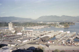
Item is photograph showing buildings in downtown Vancouver looking north west towards Stanley Park and Coal Harbour.
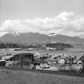
British Columbia - Vancouver skyline
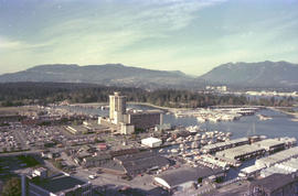
Item is photograph showing Stanley Park and Coal Harbour.

British Columbia - Vancouver skyline
Item is photograph showing Coal Harbour and Stanley Park.

British Columbia - Vancouver skyline
Item is photograph showing Stanley Park and Coal Harbour.

British Columbia - Vancouver skyline
Item is photograph showing Coal Harbour and Stanley Park.
British Columbia - Vancouver skyline
Item is photograph showing view of Coal Harbour and Stanley Park taken from Westcoast building.

British Columbia - Vancouver skyline
Item is photograph showing an aerial view of Burrard Inlet showing the southern shoreline and parts of Stanley Park.

British Columbia - Vancouver skyline
Item is aerial photograph showing part of downtown Vancouver, Stanley Park and Coal Harbour.
British Columbia - Vancouver skyline
Item is aerial photograph showing part of downtown Vancouver looking north towards Stanley Park and Coal Harbour.

British Columbia - Vancouver skyline
Item is aerial photograph showing downtown Vancouver and Burrard Inlet.

British Columbia - Vancouver skyline
Item is aerial photograph showing Coal Harbour and Burrard Inlet

British Columbia - Vancouver skyline
Item is aerial photograph of Coal Harbour and Burrard Inlet.

British Columbia - Vancouver skyline
Item is photograph showing downtown Vancouver looking north west towards Stanley Park and Coal Harbour.

British Columbia - Vancouver skyline
Item is photograph showing an aerial view of Burrard Inlet showing the southern shoreline and parts of Stanley Park.

British Columbia - Vancouver skyline
Item is aerial photograph showing Coal Harbour from the south shore.

British Columbia - Vancouver skyline
Item is aerial photograph showing Coal Harbour from the south shore.
British Columbia - Vancouver skyline : view from north side of Westcoast bldg
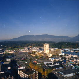
Item is photograph showing view of Coal Harbour and Stanley Park from Westcoast Energy building.
British Columbia - Vancouver skyline : view from north side of Westcoast bldg
Item is photograph showing view of Coal Harbour and Stanley Park from Westcoast Energy building.

British Columbia - Vancouver skyline : view from north side of Westcoast bldg
Item is photograph showing view of Coal Harbour and Stanley Park from Westcoast Energy building.
British Columbia - Vancouver skyline : view from north side of Westcoast bldg
Item is photograph showing view Coal Harbour and Stanley Park from Westcoast Energy building.

British Columbia - Vancouver skyline : view from north side of Westcoast bldg
Item is photograph showing view of Coal Harbour and Stanley Park from Westcoast Energy building.
British Columbia - Vancouver skyline : view from north side of Westcoast bldg
Item is photograph showing view of Coal Harbour and Stanley Park from Westcoast Energy building.

British Columbia - Vancouver skyline : view from north side of Westcoast bldg
Item is photograph showing view of Coal Harbour and Stanley Park from Westcoast Energy building.

British Columbia - Vancouver skyline : view from north side of Westcoast bldg
Item is photograph showing view of Coal Harbour and Stanley Park from Westcoast Energy building.

British Columbia - Vancouver skyline : view from north side of Westcoast bldg
Item is photograph showing view of Coal Harbour, Stanley Park, and Burrard Inlet from Westcoast Energy building.

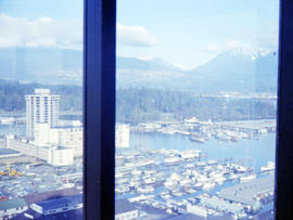
British Columbia - Vancouver skyline : Westcoast bldg. and scenery from inside
Item is photograph showing Coal Harbour and Stanley Park.

British Columbia - Vancouver skyline : Westcoast bldg. and scenery from inside
Item is aerial photograph showing Coal Harbour and Stanley Park.
British Columbia - Vancouver skyline : Westcoast bldg. and scenery from inside
Item is photograph showing Coal Harbour and Stanley Park.

British Columbia - Vancouver skyline : Westcoast bldg. and scenery from inside
Item is photograph showing Coal Harbour and Stanley Park from Westcoast Energy office building in downtown Vancouver.

British Columbia - Vancouver skyline : Westcoast bldg. and scenery from inside
Item is photograph showing Coal Harbour and Stanley Park.

British Columbia - Vancouver skyline : Westcoast bldg. and scenery from inside
Item is photograph showing Coal Harbour and downtown Vancouver.

British Columbia - Vancouver skyline : Westcoast bldg. and scenery from inside
Item is photograph showing Coal Harbour, Stanley Park, and Burrard Inlet.

British Columbia - Vancouver skyline : Westcoast building and scenery from inside
Item is photograph showing downtown Vancouver looking north west towards Stanley Park and Coal Harbour

Part of Major Matthews collection

Part of City of Vancouver Archives technical and cartographic drawing collection
Item is a sheet with three nautical charts. The main chart depicts Burrard Inlet from Atkinson Point [Point Atkinson] in the west to the "townsite of Port Moody" in the east. The inset charts depict Vancouver Harbour and the Second Narrows.
![Burrard Viaduct Construction [1 of 10]](/uploads/r/null/2/7/2788a9638050d7cbfc021e29977d956f423fe6048bb7c29c035ea57bda6dd66c/5df17b4f-3ebf-4f8d-ac21-de11bd89033f-A66652_142.jpg)
Burrard Viaduct Construction [1 of 10]
Part of City of Vancouver fonds
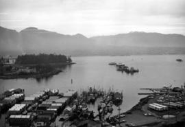
Building of Burrard Viaduct with Coal Harbour in the background, including part of Deadman's Island and a floating fuel station on the left and the mountains beyond.
![Burrard Viaduct Construction [2 of 10]](/uploads/r/null/5/7/57426101abc66a2ab407c951565e28bb07f8f27238a35bb05d7478ded4e540b1/8b87415b-c4bc-4c5c-bf5c-89e3546722c2-A66653_142.jpg)
Burrard Viaduct Construction [2 of 10]
Part of City of Vancouver fonds
Building of Burrard Viaduct with Coal Harbour in the background, including part of Deadman's Island and a floating fuel station on the left and the mountains beyond.

Canadian National Railways steamship "Prince Robert" leaving harbour
Part of Stuart Thomson fonds

Canadian National Railways steamship "Prince Robert" leaving harbour
Part of Stuart Thomson fonds

City and Deadman's Island near Nine 0'Clock Gun
Part of Major Matthews collection

City from Stanley Park, and first gasoline service station. Imperial Oil Limited.
Part of Major Matthews collection
Photograph shows the Immigration Building, the Marine Building and Deadman's Island
Item is photograph showing an aerial view of Stanley Park and Coal Harbour.

Item is photograph showing an aerial view downtown Vancouver looking northwest towards Coal Harbour and Stanley Park.

Item is photograph showing an aerial view downtown Vancouver looking northwest towards Coal Harbour and Stanley Park.
Item is photograph showing an aerial view downtown Vancouver looking northwest towards Coal Harbour and Stanley Park.

Coal Harbor Vancouver. Height of Water In Upper End 9 ft. above. Zero
Part of Major Matthews collection
Panoramic view showing Lost Lagoon, the Stanley Park Causeway under construction and the Vancouver Rowing Club.