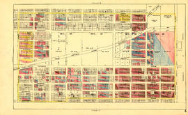
Sheet 19 : Maple Street to Richards Street and Drake Street to Third Avenue
- AM1594-MAP 779-: MAP 779.21
- Item
- [ca. 1935]
Part of City of Vancouver Archives technical and cartographic drawing collection
Item is a section showing Maple Street to Richards Street and Drake Street to Third Avenue. Includes streets, roads, blocks, lots, legal descriptions, parks, schools, the Burrard and Granville Street Bridges, C.P.R. right-of-ways, the Squamish Band reserve, C.P.R. leases and property, and government reserve. Map includes Granville Island.
Vancouver (B.C.). Office of the City Engineer