![[Aerial survey view of First Narrows, Stanley Park, the West End, Downtown and North Vancouver]](/uploads/r/null/f/8/f875c0a639388b4936ef86faafb227a0fcad6478409cc8c2ff64fa2c06296ca5/94a6f99f-1ce3-4c9b-9e48-894735d096e9-A23486_142.jpg)
[Aerial survey view of First Narrows, Stanley Park, the West End, Downtown and North Vancouver]
- AM54-S4-: Air P87
- Item
- [ca. 1956]
Part of Major Matthews collection
Perpendicular view (mosaic)
1537 results with digital objects Show results with digital objects
[Aerial survey view of First Narrows, Stanley Park, the West End, Downtown and North Vancouver]
Part of Major Matthews collection
Perpendicular view (mosaic)
![[Aerial view looking east over Stanley Park, Coal Harbour and Burrard Inlet]](/uploads/r/null/d/0/d02fee694c486ac2accdeefb505d0dae5fcb42789ef16de49322d845e3c04b44/be8c34ce-7c09-4c0e-a395-f083c9134080-A43248_142.jpg)
[Aerial view looking east over Stanley Park, Coal Harbour and Burrard Inlet]
Part of Major Matthews collection
Oblique view
![[Aerial view looking west south-west of the] District of North Vancouver](/uploads/r/null/e/c/ec241a495ce73acb4df544a3511e33bf47855c3f9780f6fdf330d5e1998b35f4/4b33b03c-3b2c-434d-877d-de90ed039d2a-A23500_142.jpg)
[Aerial view looking west south-west of the] District of North Vancouver
Part of Major Matthews collection
Oblique view. Photograph shows Deep Cove, Panorama Park, Deep Cove Yacht Club, Public Wharf (foot of Gallant Avenue), Deep Cove Resorts and Deep Cove Park.
![[Aerial view of Burrard Inlet, Hastings-Sunrise, Burnaby and the District of North Vancouver]](/uploads/r/null/d/f/df7e11c97173ce0473c454f0a01569b641972f6efdc12bf192edbc42119542d6/6d72f89b-9b55-48c4-bef6-04eb2137f1d3-A66600_142.jpg)
[Aerial view of Burrard Inlet, Hastings-Sunrise, Burnaby and the District of North Vancouver]
Part of Major Matthews collection
Photograph shows Exhibition Park and P.N.E. Golf Course, Second Narrows Bridge, New Brighton Park, Callister Park, Burrard Inlet, Lynn Creek, Lynn Park, Seymour Creek, Vancouver Harbour Commissioners Railway, Inspected Shingles Ltd., Cascade Rock and Gravel Co. Ltd., Canadian Shingle Co. Ltd. (Capilano Timber Co. Ltd.), Alberta Pool Elevator, Columbia Grain Elevator Co. Ltd., Canadian Pacific Railway, Girls Industrial School and Old Peoples Home sites.
Part of Dunbar History Project fonds
Item filed under Parks. Courtesy of Vancouver Parks Board.
Part of Dunbar History Project fonds
Item filed under Parks. Courtesy of Vancouver Park Board.

Part of Dunbar History Project fonds
Item filed under Parks. Courtesy of Vancouver Park Board.
Aerial view of Memorial West Park
Part of Dunbar History Project fonds
Item filed under Parks. Courtesy of Vancouver Park Board.

Aerial view of Memorial West Park
Part of Dunbar History Project fonds
Item filed under Parks. Courtesy of Vancouver Park Board.
![[Aerial view of Mount Pleasant, South Strathcona and Kensington-Cedar Cottage]](/uploads/r/null/7/5/75ea991fe8319eaffda79b314cbf20e281e35eb2cd8a89eaa898b492242d6282/05f856f3-0a45-41eb-94dc-46cb9d2f7ecf-A63348_142.jpg)
[Aerial view of Mount Pleasant, South Strathcona and Kensington-Cedar Cottage]
Part of Major Matthews collection
Photograph shows aerial view of the east end of False Creek, Thornton Park, Great Northern Railway and Canadian National Railway yards, Mount Pleasant, Strathcona, Grandview-Woodland, Trout Lake, Kingsway, Vancouver Technical School grounds, Renfrew playing fields, John Hendry Park, British Columbia Electric Railway Right of Way, Clark Park, Grandview Highway South, Great Northern Railway.
Part of Dunbar History Project fonds
Item filed under Parks. Courtesy of Vancouver Park Board.

Part of Dunbar History Project fonds
Item filed under Parks. Courtesy of Vancouver Park Board.

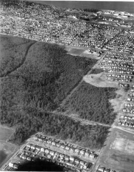
Aerial view of New Brighton Park site, looking east from Renfrew Street
Part of Wilson family fonds
Image shows grain elevators and Canadian Pacific Rails.

Aerial view of New Brighton Park site, looking west along waterfront toward foot of Renfrew Street
Part of Wilson family fonds
![[Aerial view of Stanley Park from downtown, 1 of 2]](/uploads/r/null/e/a/2/ea2fa7aeab8d090954336d4db69c725ba8abe57666d3be52009dbd001144c31e/c53aa37e-5123-4247-bfcf-31b31651977f-CVA1095-07042_142.jpg)
[Aerial view of Stanley Park from downtown, 1 of 2]
Part of City of Vancouver fonds
![[Aerial view of Stanley Park from downtown, 2 of 2]](/uploads/r/null/8/d/f/8dfcdae0f34fc74635d4083942eb671c0ef2a5ac52c683008bafec1a8ee3e3ec/c8facdb8-84fd-459b-935a-f90e79b7a972-CVA1095-07043_142.jpg)
[Aerial view of Stanley Park from downtown, 2 of 2]
Part of City of Vancouver fonds
![[Aerial view of the West End showing the increase of apartment buildings west of Cardero Street]](/uploads/r/null/9/4/9410444a29ad3e6e13228ba5ad44b40986af7ad70945337641000d03b991a529/ee9fb9e8-21b9-4ca5-a5b6-d28e6d51046e-A25977_142.jpg)
[Aerial view of the West End showing the increase of apartment buildings west of Cardero Street]
Part of Major Matthews collection
Photograph shows oblique view of Lost Lagoon, Stanley Park and Lord Roberts School
![[Aerial view of Vancouver]](/uploads/r/null/b/9/b973b9a4143a5316b02e728c35d99e383f27a3db21d8e20aa7bbb459780243bc/3ff38b56-6b36-4c17-bce1-329c97459d29-A66598_142.jpg)
Part of Major Matthews collection
Photograph shows Kitsilano, Kits Point, Kitsilano Beach, R.C.A.F. Equipment Depot, Kitsilano Pool, Burrard Bridge, C.P.R. Kitsilano Trestle, Granville Island, Granville Bridge, Cambie Bridge, False Creek, C.P.R. False Creek Yards, West End, Yaletown, Arbutus Ridge, Shaughnessy, South Cambie, Fairview, Mount Pleasant, Little Mountain Reservoir, Connaught Park, Quilchena Golf Course, Douglas Park, Shaughnessy Heights Golf Course, Queen Elizabeth Park, Royal Canadian Mounted Police Barracks, Shaughnessy Military Hospital, Hillcrest Park, Robertson & Hacket Sawmill, City Yard, West Coast Ship Builders and Athletic Park.
![[Aerial view of Vancouver Harbour from Stanley Park looking east to Indian Arm]](/uploads/r/null/c/b/cb066fdc626d69001bfb4c896937f586737298cc09ee0de3cc7fdd0bca8df09e/93414b9d-edd5-4e76-a79d-fb7a26360472-A31831_142.jpg)
[Aerial view of Vancouver Harbour from Stanley Park looking east to Indian Arm]
Part of Major Matthews collection
Oblique view
![[Aerial view of West Point Grey, Kitsilano, Dunbar - Southlands and University Endowment Lands]](/uploads/r/null/0/8/089d213e9a81ca689130a244122a86972e068c9b01ab994922a88072ac881121/1ed71859-c157-4686-82db-e3483cd4b877-A66599_142.jpg)
[Aerial view of West Point Grey, Kitsilano, Dunbar - Southlands and University Endowment Lands]
Part of Major Matthews collection
Photograph shows the south Slope of English Bay, Spanish Banks, Locarno Beach Park, Jericho Beach, R.C.A.F. Jericho Air Station, Kitsilano pool, Connaught Park and Kitsilano Beach Park, Caldecott Park, Quilchena Golf Course, School for Deaf and Blind and Quesnel Park.

Aerial view, Brockton Point Lighthouse and part of waterfront, Vancouver, B.C.
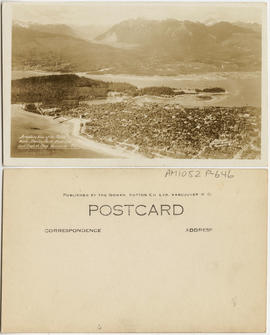
Aeroplane view of the North Shore - Stanley Park - West End and English Bay - Vancouver B.C.
![[Alexandra Park]](/uploads/r/null/a/a/aa5a43bde770806111c0ea2763e09c8c4c0f2e7d7f83b4c4e6390acf8746b454/a68477f1-afa8-422b-940e-99edad20867e-A59294_142.jpg)
Part of City of Vancouver fonds
Part of Major Matthews collection

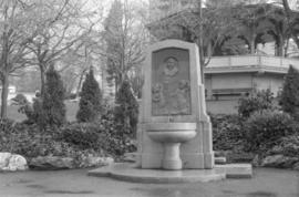
Alexandra Park - Joe Fortes Memorial drinking fountain, back
Part of City of Vancouver fonds

Alexandra Park - Joe Fortes Memorial drinking fountain, front (bandstand behind)
Part of City of Vancouver fonds
Alexandra Park - Joe Fortes Memorial drinking fountain, front (bandstand behind)
Part of City of Vancouver fonds

Alexandra Park - Red Oak (Cardero Street and Beach Avenue)
Part of City of Vancouver fonds

Item is a photograph of the bandstand at Alexandra Park, English Bay. Two small children walk on the grass near the bandstand and the English Bay Pier can be seen in the lower left background.

Allscreen - Vancouver - reel #2
Part of Yaletown Productions Inc. fonds
Film consists of raw footage of scenes of Vancouver used in the video postcard "Vancouver - The World in a City." Footage features the City of Vancouver, and includes harbour views, the train in Stanley Park loading and unloading tourists as well as the train ride views; including some zoo animals, children at the petting zoo, Granville Island; especially the Public Market, False Creek Ferries, a view of the Granville Street bridge, the Burrard Street bridge and views from the Granville Street bridge looking downtown. Silent film.
Allscreen - Vancouver - reel #4
Part of Yaletown Productions Inc. fonds
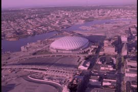
Film consists of raw footage of scenes of Vancouver used in the video postcard "Vancouver - The World in a City." Film features aerial views of: B.C. Place Stadium, the City of Vancouver from Stanley Park, Coal Harbour, the seawall, Stanley Park, the downtown area, the B.C. Ferries-run seabus, the Vancouver Trade and Convention Centre still under construction, the Expo Centre (now the Telus World of Science) under construction, as well as views of the development of the Expo site, the Fraser river, log booms on the Fraser river, the Airport, the University of British Columbia campus, and the Lions Gate bridge. Silent film.
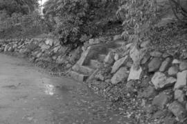
Almond Park dry rock wall and cut granite steps
Part of City of Vancouver fonds
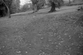
Almond Park path on bank (not well articulated)
Part of City of Vancouver fonds
Part of City of Vancouver fonds
Part of City of Vancouver fonds

Almond Park, looking west - Copper Beach
Part of City of Vancouver fonds
Almond Park, West 13th Avenue, street end
Part of City of Vancouver fonds

Along Tatlow Walk, Stanley Park, Vancouver, B.C.

Alpine and Montane : Hurricane Ridge- view from ridge to west
Image shows view from Hurricane Ridge in Olympic National Park, Washington.

Alpine and Montane : sub-alpine meadow, Hurricane Ridge
Image shows trees and flowering plants at Hurricane Ridge, Olympic National Park, Washington.
Part of Major Matthews collection

Part of William Orson Banfield fonds

Part of City of Vancouver fonds

Part of City of Vancouver fonds
![[Anniversary Quarry Garden plaque, Queen Elizabeth Park]](/uploads/r/null/7/1/d/71d32d280794582b861f96a73e6f8dd5a8d1997c38bbe9c743b6685ae24dfa0f/3d0a0259-63f2-47c7-94ca-07c3a54ae532-CVA1095-01090_142.jpg)
[Anniversary Quarry Garden plaque, Queen Elizabeth Park]
Part of City of Vancouver fonds
![[Apodaca Park (D.L. 4974) and Cove from the water]](/uploads/r/null/f/a/faba6e0b8b4c25db985f0ca724b2a9fedce0624d266f732170d6186c4ab3e826/8d74a0d3-3836-4f71-ab01-50ff1ee8b9d5-A59989_142.jpg)
[Apodaca Park (D.L. 4974) and Cove from the water]
Part of Major Matthews collection
Panoramic view
![[Apodaca Park (D.L. 4974) and Cove from the water]](/uploads/r/null/8/3/1/831e92f91dc63f1a13b6ac1d30818605131d79cd305173eae5b335537206cc75/a949b3da-0421-4e99-8ab9-dd0b5103947c-CVA371-215_142.jpg)
[Apodaca Park (D.L. 4974) and Cove from the water]
Part of Major Matthews collection
Item is a photograph made of 3 separate photographs joined together. Panoramic view. The sections have been described separately as CVA 371-215.1, CVA 371-215.2 and CVA 371-215.3.
Application for amendment to Zoning and development by-law no. 3576
Item includes a signed petition, aerial photo and map.
Appreciation for plan of development : Queen Elizabeth Arboretum, September, 1949