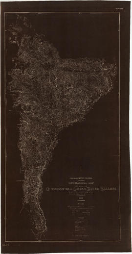
Topographical map of parts of the Cheakamus and Green River valleys
- COV-S346-F01-: MAP 1075
- Item
- 1930
Part of City of Vancouver fonds
264 results with digital objects Show results with digital objects
Topographical map of parts of the Cheakamus and Green River valleys
Part of City of Vancouver fonds
Part of City of Vancouver fonds
Item is a portion of a topographical map showing Green Lake, the headwaters of the Green River, and the portions of 21 Mile Creek and Fitzsimmons Creek where they empty into Green Lake. The remaining portion of the map shows the Green Lake area from District Lot 2015 to 3336. The map is missing its right-hand portion and title block, though the style and hand are the same as other maps created by the City Engineer's Office as a result of the 1923 surveys of the Squamish, Cheakamus and Green rivers.
The sheet also contains three sections: one of Fitzsimmons Creek at the Pacific Great Easter Railway bridge 40.5, one of the Green River and one of the valley north-west of Green Lake along which the PGE line runs.

Plan of Lots 179, 180 & 181 Lillooet District
Part of City of Vancouver fonds

Part of City of Vancouver fonds

Profile Mile 27 to Mile 58 Port Mann Subdivision
Part of City of Vancouver fonds
Item is a profile of the Canadian Northern Railway right of way through the Fraser Valley.

Profile Mile 0 to Mile 27 Port Mann Subdivision
Part of City of Vancouver fonds
Item is a profile depicting the Great Northern Railway right of way in the Fraser Valley.

Profile of Lillooet River from Tenas Lake to Harrison Lake
Part of City of Vancouver fonds
Item is a map sheet showing a profile of the Lillooet River and cross-sections at the following locations: 210+00, 320+00, 383+00, 534+00, 1005+00 and the bridge at 1350+00.

Plan and profile from Cultus Lake to Vedder Crossing
Part of City of Vancouver fonds
Item is a map sheet that contains one main map showing the area between Cultus Lake and Vedder Crossing. The sheet also contains four cross-sections of the Chilliwack River. MAP 1117 appears to be a draft version in the hand of the surveyor, H. Idsardi.

Plan and profile from Cultus Lake to Vedder Crossing
Part of City of Vancouver fonds
Item is a map sheet that contains one main map showing the area between Cultus Lake and Vedder Crossing. The sheet also contains four cross-sections of the Chilliwack River. The map appears to be a draft version of MAP 1118.

Part of City of Vancouver fonds
Item is a map which depicts two alternative routes for running power pole lines from a power house on the Cheakamus River to Burrard Inlet: along the Cheakamus River, with an alternative route along Seymour Creek.

Contour map shewing proposed location of flume, reservoir and power plant Cheakamus River, B.C.
Part of City of Vancouver fonds
Item is a copy of a map that appears to have been created as part of power development proposal by DuCane, Dutcher & Co. The map was likely acquired by the City Engineer's Office as a reference map for surveying work done in the Cheakamus River area in 1923.
Item is a map showing a surveyor's traverse of the perimeter of Brockton Point and interior roads.
Vancouver Park Board
Fraser River and Burrard Inlet
Part of City of Vancouver Archives technical and cartographic drawing collection
Item is a nautical chart which show details of the area surveyed from Pitt Lake in the north to Roberts Bank in the south and from (what is now) Harrison Hot Springs in the east to Bowen Island in the west. The chart shows soundings in Burrard Inlet, and along the Fraser River.
Lower mainland air quality study, summary report
Check list survey of multi-problem families
Fraser River and Burrard Inlet
Part of Major Matthews collection
Christmas Bird Count data collection sheets, 2016
Christmas Bird Count data collection sheets, 2015
Christmas Bird Count data collection sheets, 2014
Christmas Bird Count data collection sheets, 2013
Christmas Bird Count data collection sheets, 2012
Christmas Bird Count data collection sheets, 2011
Christmas Bird Count data collection sheets, 2010
Christmas Bird Count data collection sheets, 2009
Christmas Bird Count data collection sheets, 2008
Christmas Bird Count data collection sheets, 2007
Christmas Bird Count data collection sheets, 2006
Christmas Bird Count data collection sheets, 2005
Christmas Bird Count data collection sheets, 2004
Christmas Bird Count data collection sheets, 2003
Christmas Bird Count data collection sheets, 2002
Christmas Bird Count data collection sheets, 2001
Christmas Bird Count data collection sheets, 2000
Christmas Bird Count data collection sheets, 1999
Christmas Bird Count data collection sheets, 1998
Christmas Bird Count data collection sheets, 1997
Christmas Bird Count data collection sheets, 1996
Christmas Bird Count data collection sheets, 1995
Christmas Bird Count data collection sheets, 2017
Jericho Park Habitat Survey Volume A and Volume B
Jericho Park Habitat Survey Data Form sheets
Jericho Park Habitat Survey Data Form sheets

North America. West Coast. Fraser River and Burrard Inlet
Part of City of Vancouver Archives technical and cartographic drawing collection
Item is a nautical chart which show details of area surveyed from Pitt Lake in the north to Roberts Bank in the south and from (what is now) Harrison Hot Springs in the east to Bowen Island in the west. The chart shows soundings in Burrard Inlet, and along the Fraser River.

General plan of proposed development of Alouette water power
Part of City of Vancouver fonds
Fraser River and Burrard Inlet
Part of Major Matthews collection

Fraser River and Burrard Inlet
Part of Major Matthews collection