- COV-S388---: LEG1348.07
- Item
- 1956
Part of City of Vancouver fonds
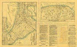
Item is a map showing pedestrian traffic volumes by people per linear foot of street for the downtown area bounded by Burrard Street, Robson Street, and Nicola Street in the west and Main Street in the east.




![Untitled [968 of 991]](/uploads/r/null/c/d/cda7470443c0037d59da9261021f7964e8c40d8026f16be63ef77e81e29cb5d1/b764cbd4-831d-4e59-8e3a-51d3c51e737d-A69378_142.jpg)
![Untitled [967 of 991]](/uploads/r/null/1/a/1ac1c953383038a17662668715ca471757e2f3f8dc4ca9cf3d1f7f143074f096/4e31420e-3576-4e57-9bf3-580dd3852f66-A69377_142.jpg)
![Untitled [471 of 991]](/uploads/r/null/b/1/b13ba1d1f337d9e2d2f170cf3ecb1ec6a87498c4becb94f477d4662715c52e1f/4afe3b00-f3a4-46ca-931d-04f9aa60c176-A68437_142.jpg)
![Kensington Park [11 of 17]](/uploads/r/null/c/d/cdea9c7950b7b93244e27cc482149b090038197a8cf7e2855944e2ac93c0d65e/b8495402-dce6-4563-a157-c81541b61046-A66328_142.jpg)
![Miscellaneous [42 of 130]](/uploads/r/null/a/f/af44f9354a84840abfd83f918936890c7c156600112573e3ef22bbc5cc047ca9/0d79d306-dfc4-4932-af34-a5254784f375-A64368_142.jpg)





![Birk's Clock, detail [Granville Street at West Georgia]](/uploads/r/null/4/8/1/4818e1ad9348156599f9edd8305906d577395b8b5f7dd8e7a7c6593680afe51b/10c8f46e-c673-4c7a-9fc0-e1828d826ead-CVA792-380_142.jpg)
![Birk's Clock [Granville Street at West Georgia]](/uploads/r/null/a/9/6/a9697d6cc40854505b0b4a9a14831053be80ab68faa24a88551272cc2a71f88a/c19b38e7-1228-4e0e-9147-8f3e7408be73-CVA792-379_142.jpg)
![Birk's Clock [Granville Street at West Georgia]](/uploads/r/null/0/a/d/0ad3da3110d5890257eadc871d29c0cae6bf1a3bde35a0380bbaea8b4edd27b5/9a0d1777-c02d-4bb0-9443-25751fca24f9-CVA792-378_142.jpg)

