Sheet 2 : Boundary Road to Venables Street to Lakewood Street to East Fourteenth Avenue
Sheet 10 : Clarendon Street to Forty-ninth Avenue to St. George Street to Fraser River

Sheet 15 : Columbia Street to Drake Street to Cypress Street to West Eighteenth Avenue
Sheet 24 : Balaclava Street to English Bay to Tolmie Street to Nineteenth Avenue

Redevelopment plan for Jericho Department of National Defence lands

Pacific National Exhibition grounds plan
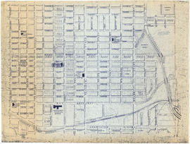
![[Sheet 7 : Burrard Street to Main Street and Georgia Viaduct to Burrard Inlet]](/uploads/r/null/c/d/cd235086cbaf81487b8784fb32b6ef913f4fe27305678cd1961adf506324c250/8f72f6bd-1013-48ad-a56c-e6269cb6f5a8-MAP339_142.jpg)
[Sheet 7 : Burrard Street to Main Street and Georgia Viaduct to Burrard Inlet]
![[Sheet 9 : Main Street to Clark Drive and Prior Street to Burrard Inlet]](/uploads/r/null/c/a/ca4b4713bea0118fec812e6258afe5c1efa039db74073214703001a47b00f122/5e0d243a-99ae-42aa-8bb3-4a1abe9e1209-MAP339_142.jpg)
[Sheet 9 : Main Street to Clark Drive and Prior Street to Burrard Inlet]
![[Sheet 21 : Homer Street to Main Street and Fourth Avenue to Georgia Viaduct]](/uploads/r/null/8/c/8c7ce2ae32274b3000b670b2a47c1114fd3c3faf20caeaef1a64c8137aab4f37/d256dda0-fa87-4985-97d6-ed6431e5a608-MAP339_142.jpg)
[Sheet 21 : Homer Street to Main Street and Fourth Avenue to Georgia Viaduct]
![[Sheet 24 : Jericho Beach to Balaclava Street and Fourth Avenue to Cameron Avenue]](/uploads/r/null/e/7/e737857a87702a8fbd029d7bdb109697279cac537d45931818415e380dd2867c/67258081-9a3b-44c0-9191-8a3719f6c999-MAP339_142.jpg)
[Sheet 24 : Jericho Beach to Balaclava Street and Fourth Avenue to Cameron Avenue]

[Sheet 27 : University Endowment Lands and Drummond Drive to Camosun Street and Fourteenth Avenue to Fourth Avenue]
![[Sheet 29 : Balaclava Street to Maple Street and Fourteenth Avenue to Third Avenue]](/uploads/r/null/d/6/d672783fbbcdf46b6e25dc13c2f50caa22e19935f01490a9053af4afffc83c80/9a39458e-9f4b-43a8-a595-082419eecd5b-MAP339_142.jpg)
[Sheet 29 : Balaclava Street to Maple Street and Fourteenth Avenue to Third Avenue]
![[Sheet 35 : Rupert Street to Ardley Avenue and Grandview Highway to Fifth Avenue]](/uploads/r/null/b/9/b99ee96b798b34d2651dd213f0a858725b96bd6d586dd8d3701744c75c085139/a2e07931-8625-4adb-a51a-547f78416127-MAP339_142.jpg)
[Sheet 35 : Rupert Street to Ardley Avenue and Grandview Highway to Fifth Avenue]
![[Sheet 40 : Inverness Street to Nanaimo Street and Twenty-second Avenue to Thirteenth Avenue]](/uploads/r/null/9/3/9367a0c50f6fa513d717a1972b1bac72acde6d41b002fefcf48ddbd8c8122e8a/c7bfac0b-bf44-441b-b059-fd7bbc0bd4a0-MAP339_142.jpg)
[Sheet 40 : Inverness Street to Nanaimo Street and Twenty-second Avenue to Thirteenth Avenue]
![[Sheet 41 : Ontario Street to Inverness Street and Twenty-eighth Avenue to Sixteenth Avenue]](/uploads/r/null/c/2/c22ca2538905633f64373261ce970df6216075ce4de9e22d491c2e212ce17c1f/616ab944-e39a-4c66-abb4-918b17cc3252-MAP339_142.jpg)
[Sheet 41 : Ontario Street to Inverness Street and Twenty-eighth Avenue to Sixteenth Avenue]
![[Sheet 43 : East Boulevard to Oak Street and Laurier Avenue to Fourteenth Avenue]](/uploads/r/null/8/8/8846e3e6c19438103b656786c264d5dcccc37b59de3cf8fa85bb05f01b65d8f9/9fb3d6cb-93e9-48d0-be52-05cc55ad4ec4-MAP339_142.jpg)
[Sheet 43 : East Boulevard to Oak Street and Laurier Avenue to Fourteenth Avenue]

[Sheet 55 : Cecil Street and McHardy Street to Patterson Avenue and Kingsway to Monmouth Avenue and Price Street]
![[Sheet 56 : Doman Street and Joyce Street to Boundary Road and Forty-ninth Avenue to Kingsway]](/uploads/r/null/5/e/5ee0f6b78ce9f3b0e0e39795d6220cd37d587872bad7b41b67f4d29c7cb49d4c/f8a321d6-ea4f-4e1f-85da-6d12e149ea85-MAP339_142.jpg)
[Sheet 56 : Doman Street and Joyce Street to Boundary Road and Forty-ninth Avenue to Kingsway]

[Sheet 57 : Nanaimo Street to Doman Street and Joyce Street and Forty-ninth Avenue to Forty-first Avenue]
![[Sheet 65 : Camosun Street to Carnarvon Street and Forty-first Avenue to Thirty-third Avenue]](/uploads/r/null/4/0/407c98f21cf3d2ce519b79e8a505fd6a325c965dc1550cdbc00d96b7bc7e5e3d/04862e6e-5125-4593-84de-c80135fd76ce-MAP339_142.jpg)
[Sheet 65 : Camosun Street to Carnarvon Street and Forty-first Avenue to Thirty-third Avenue]
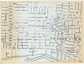
![[Sheet 78 : Kerr Street to Ivy Avenue and North Arm of Fraser River to Southeast Marine Drive]](/uploads/r/null/9/0/90c6186a1aa17588ec162078d412440a826f55dc10a9d49f8e74df97a4d3ff6e/0a3e4f49-3d6d-4dec-95f1-08aa42e666d8-MAP339_142.jpg)
[Sheet 78 : Kerr Street to Ivy Avenue and North Arm of Fraser River to Southeast Marine Drive]

[Sheet 82 : Main Street to Tipping Road and Crompton Street and Twigg Island to Southeast Marine Drive]
![[Sheet 83 : Fremlin Street to Main Street and Southwest Marine Drive to Fifty-seventh Avenue]](/uploads/r/null/3/e/3efc869894db6ec7c88cf96b10cd2cb7f93db04cae7e1f6f35be1ac51c2bdc14/6323fdeb-3ce2-4794-bc7f-691ce81ee431-MAP339_142.jpg)
[Sheet 83 : Fremlin Street to Main Street and Southwest Marine Drive to Fifty-seventh Avenue]
![[Sheet 86 : Angus Drive to Laurel Street and Seventy-fifth Avenue to Sixty-seventh Avenue]](/uploads/r/null/6/e/6efd95dacdad7f8976575767597855d90ccaa34e423b1ba76885d33d2dffb725/8167b0a2-0792-4e60-9755-7a4706830df0-MAP339_142.jpg)
[Sheet 86 : Angus Drive to Laurel Street and Seventy-fifth Avenue to Sixty-seventh Avenue]
![[Sheet 88 : Macdonald Street to Angus Drive and Edgington Avenue to Fifty-seventh Avenue]](/uploads/r/null/5/9/595b991e091f624b5f74507db063dddb150624fbef03fe1d577f8d7a32bb9088/8afa1350-f31b-43bd-a14f-0ea9082c21fe-MAP339_142.jpg)
[Sheet 88 : Macdonald Street to Angus Drive and Edgington Avenue to Fifty-seventh Avenue]

City of Vancouver, British Columbia

Index to 400 ft. scale section maps, City of Vancouver, British Columbia, index map 40
![[Sheet 6 : Nicola Street to Beatty Street and English Bay Beach to Georgia Street]](/uploads/r/null/f/2/f2effc97084427c0bd73bae3566d3ad910caaa6e7fb3e5ed9f3ece81bd2ac0a1/f2cc48a6-1195-4dd8-8227-71d36d1791bb-MAP339_142.jpg)
[Sheet 6 : Nicola Street to Beatty Street and English Bay Beach to Georgia Street]
![[Sheet 12 : Nanaimo Street to Cassiar Street and Pender Street to McGill Street]](/uploads/r/null/6/0/603c1cdc3adb1f0dec963bbd885c378ce1e23c71767cb0b461ef6ccc54807a5a/49483dc1-d90f-4a82-86cd-3c7a09f2ddae-MAP339_142.jpg)
[Sheet 12 : Nanaimo Street to Cassiar Street and Pender Street to McGill Street]
![[Sheet 16 : Rupert Street to Gilmore Avenue and Fifth Avenue to Kitchener Street]](/uploads/r/null/6/2/6247d4ce631b144e891bbf078d02b8397e56f53625f45e0c464d4bc0e213b752/d68185e8-9db3-488c-a115-03184f2e1941-MAP339_142.jpg)
[Sheet 16 : Rupert Street to Gilmore Avenue and Fifth Avenue to Kitchener Street]
![[Sheet 33 : Clark Drive to Nanaimo Street and Thirteenth Avenue to Second Avenue]](/uploads/r/null/5/e/5ef811f96e8c284708c2b73dafde35219a65ddca967ebd7473adfc3e76a171d6/a1b4e29f-54ea-431a-8eff-df608d7e60ff-MAP339_142.jpg)
[Sheet 33 : Clark Drive to Nanaimo Street and Thirteenth Avenue to Second Avenue]
![[Sheet 39 : Kingsway and Nanaimo Street to Rupert Street and Ward Street to Twenty-second Avenue]](/uploads/r/null/0/4/0409c276b1c046750a9680e1310ce46ec18fce0f1dfc928aab80fbe273730918/665972e9-723b-462b-b30f-95f1484b2c51-MAP339_142.jpg)
[Sheet 39 : Kingsway and Nanaimo Street to Rupert Street and Ward Street to Twenty-second Avenue]
![[Sheet 47 : Camosun Street to Blenheim Street and Thirty-third Avenue to King Edward Avenue]](/uploads/r/null/5/9/59c6b01a85dc6051f7cfecf1f33eb7e7017beb24d0dd57b512fcddc2063e3e8f/eabe5a9f-362b-46a4-9efc-275f9b96459b-MAP339_142.jpg)
[Sheet 47 : Camosun Street to Blenheim Street and Thirty-third Avenue to King Edward Avenue]
![[Sheet 53 : Inverness Street to Nanaimo Street and Forty-first Avenue to Thirty-second Avenue]](/uploads/r/null/a/9/a9fdfc1181cd3a36ad078c24a5892d8bfc60c5456733839fa59914d5700e6509/5f8f4fc4-26e4-49f3-b5d4-acced16d8490-MAP339_142.jpg)
[Sheet 53 : Inverness Street to Nanaimo Street and Forty-first Avenue to Thirty-second Avenue]

[Sheet 54 : Nanaimo Street to Joyce Street, Cecil Street and McHardy Street and Forty-first Avenue to Ward Street and Vanness Avenue]
![[Sheet 58 : Inverness Street to Nanaimo Street and Forty-ninth Avenue to Forty-first Avenue]](/uploads/r/null/5/5/55825f5529a2ab4a1b9c04e6d086f342c86830cc9828262a5f7b22eab255b346/4ce8baf7-a89b-4c24-bec2-d1a45477ca67-MAP339_142.jpg)
[Sheet 58 : Inverness Street to Nanaimo Street and Forty-ninth Avenue to Forty-first Avenue]
![[Sheet 60 : Oak Street to Quebec Street and Forty-sixth Avenue to Thirty-seventh Avenue]](/uploads/r/null/b/5/b5e1b3fe1dda55eb9d0029fcbe47cb6048a48720c1ad1f7b1897640d35203319/e097b4d6-7a5c-41bc-9ca5-1b9e7b57eccc-MAP339_142.jpg)
[Sheet 60 : Oak Street to Quebec Street and Forty-sixth Avenue to Thirty-seventh Avenue]
![[Sheet 63 : Carnarvon Street to Cypress Street and Forty-first Avenue to Thirty-third Avenue]](/uploads/r/null/4/3/43f21afad72cf7d769c23be0a8b778e288335df1801a3b9d42bace4e74c8ea1a/64b6fa50-ede8-4087-81fc-6b7da9b7dfd1-MAP339_142.jpg)
[Sheet 63 : Carnarvon Street to Cypress Street and Forty-first Avenue to Thirty-third Avenue]
![[Sheet 64 : Balaclava Street to Cypress Street and Forty-ninth Avenue to Forty-first Avenue]](/uploads/r/null/6/d/6d41bb5db0383d13fdc92e51638fb1e2c9ac8e11a664fd9070ee16be3212d8f5/07989ba9-42ff-4d9a-ac56-a25405a93120-MAP339_142.jpg)
[Sheet 64 : Balaclava Street to Cypress Street and Forty-ninth Avenue to Forty-first Avenue]
![[Sheet 79 : Gladstone Street to Kerr Street and North Arm of Fraser River to Bobolink Avenue]](/uploads/r/null/7/9/79214408afd85e4ab6ccc7eec43ecc85caf5ce5dedb9cfeb219866aa0091a733/7696de5a-3bba-4c2d-bc6c-83bf14bcf845-MAP339_142.jpg)
[Sheet 79 : Gladstone Street to Kerr Street and North Arm of Fraser River to Bobolink Avenue]

[Sheet 80 : Tipping Road, Crompton Street and Inverness Street to Gladstone Street and Mitchell Road to Sixty-first Avenue]

Vancouver, New Westminster, Delta and Surrey : postal area
![[Sheet 5 : Stanley Park to Nicola Street and English Bay Beach to Robson Street]](/uploads/r/null/1/d/1daf1ff2196704e4e82a6b5c7476ee3e8a46b4e0740f3c37f3f58813f5f8b5f0/ee3a2706-4ebe-4ee8-b4db-da89840c7f89-MAP339_142.jpg)
[Sheet 5 : Stanley Park to Nicola Street and English Bay Beach to Robson Street]
![[Sheet 8 : Main Street to Clark Drive and Alexander Street to Burrard Inlet]](/uploads/r/null/a/1/a10fe461f7836acc659d886d1888eef9d17bfc99d33e474c29ae025ed531b50c/e81d36a6-a6c1-40a5-852b-ef52bfbdb8dd-MAP339_142.jpg)
[Sheet 8 : Main Street to Clark Drive and Alexander Street to Burrard Inlet]
![[Sheet 11 : Wall Street to Rupert Street and McGill Street to Burrard Inlet]](/uploads/r/null/e/b/eb84fb8de9ca2e1644a2e39bcbaad5253c563e8716cf25114e675fb7d40365ea/0935fb81-4662-411a-bdfd-c9823c7fb82b-MAP339_142.jpg)
[Sheet 11 : Wall Street to Rupert Street and McGill Street to Burrard Inlet]
![[Sheet 14 : Cassiar Street to Carleton Avenue and Pender Street to Eton Street]](/uploads/r/null/a/4/a404347152c9328da5ec443862d19bc937a2199f1ce3cde01729819bfd1272d2/5ec2b15f-3c41-4c16-8567-f00ced74929f-MAP339_142.jpg)
[Sheet 14 : Cassiar Street to Carleton Avenue and Pender Street to Eton Street]
![[Sheet 15 : Rupert Street to Carleton Avenue and Kitchener Street to Pender Street]](/uploads/r/null/b/7/b7b353e0ba4ef92f21d8b4148594896da61b022d62168ec30d592e80b71eb373/6461e269-e3e0-4cad-b202-be701b9eac5b-MAP339_142.jpg)
[Sheet 15 : Rupert Street to Carleton Avenue and Kitchener Street to Pender Street]
![[Sheet 23 : Balaclava Street to Maple Street and Third Avenue to English Bay]](/uploads/r/null/3/a/3a54a965065dcf8e280a31b4062305fcb93608d40098e982820d383458c84410/0437e9bd-e467-4a81-83ee-f6e9e7ec43b2-MAP339_142.jpg)
[Sheet 23 : Balaclava Street to Maple Street and Third Avenue to English Bay]
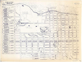
![[Sheet 25 : Blanca Street to Jericho Beach and Fourth Avenue to Locarno Beach]](/uploads/r/null/a/a/aa0a0c46231b6c2f088187b2268cd829388fc6dd96aa8123f7a8f43d92c642cb/395c09b4-af3a-4986-8987-c83c92a27d94-MAP339_142.jpg)
[Sheet 25 : Blanca Street to Jericho Beach and Fourth Avenue to Locarno Beach]
![[Sheet 30 : Maple Street to Oak Street and Fourteenth Avenue to Third Avenue and False Creek]](/uploads/r/null/2/f/2f9cbcb3930282909d8a62f01384c5c21cf803594c41529ced8de9bed70e9575/e94bfa39-bc0b-46aa-9bdd-b2c0b97f5eba-MAP339_142.jpg)
[Sheet 30 : Maple Street to Oak Street and Fourteenth Avenue to Third Avenue and False Creek]