![[Ships in Vancouver Harbour]](/uploads/r/null/d/6/d629566f7cb9f7a78af71c85ba3ea4a2cf7167728b91400cee1d65fd777443b3/fbfab785-d4fa-4637-8632-cf9d4b4bddca-A08055_142.jpg)
[Ships in Vancouver Harbour]
![Harbour panorama [with] war canoe](/uploads/r/null/1/3/5/13571c1c3dc1e530a1e923e7264be75706d8af95af9a588dcf00ff1206d334c5/cd1f3b56-7afa-4c5c-ac2a-92ed07ed331a-2011-010_142.jpg)
Harbour panorama [with] war canoe

Waterfront looking west
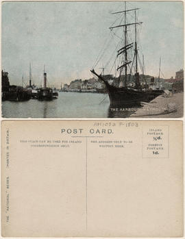
The Harbour, Weymouth

Inner harbour, Mevagissey

Torquay Harbour

Inner Harbour Victoria B.C.
![[View of Coal Harbour and the rear of Queen Victoria's Memorial from Stanley Park]](/uploads/r/null/4/3/43de497a997e0f724c44d286a5777cf01177bc80cf064bb190ff8d322f1a3431/ab850521-fb13-4aa6-8b76-7ae76dab47a7-A64524_142.jpg)
[View of Coal Harbour and the rear of Queen Victoria's Memorial from Stanley Park]
![[Queen Victoria Memorial Fountain]](/uploads/r/null/f/b/c/fbc8607cfbb0c77b361e1848d986e2ef78b715bb554ba8a0769d86d3e082ed38/bebd2627-01c5-42b2-9d75-24f222aaf42d-MonP32_142.jpg)
[Queen Victoria Memorial Fountain]

No. 1053, Burrard Inlet, Vancouver, B.C.

Plan of Vancouver Harbour and False Creek, Vancouver, B.C., showing proposed improvements as outlined in Jos. R. Roy's reports dated 15th Sept. 1906
Plan of False Creek, Vancouver, B.C.
Plan of False Creek, Vancouver, B.C.

Empress of China at dock, 1906, Vancouver, B.C.

A glimpse of the city from Stanley Park
![[Ships in Vancouver Harbour; Johnson Wharf]](/uploads/r/null/d/3/d3d981769b95551634534c3b79335d133d4f5e5d1df87be38fc182f6aad7df2a/0546b510-b33e-42c4-b61c-449552679d73-A02418_142.jpg)
[Ships in Vancouver Harbour; Johnson Wharf]
![[Northeast view of downtown Vancouver from the roof of the Hotel Vancouver]](/uploads/r/null/d/e/de95d099d1517793665187336820ebdb65db9f066b651b935a78788383053fb3/5b49058f-4381-43c8-b28f-9755248fa953-A63006_142.jpg)
[Northeast view of downtown Vancouver from the roof of the Hotel Vancouver]
![[South side of Coal Harbour at low tide with four-man scull]](/uploads/r/null/5/d/5d701a946729d7f820e43fd05966163d0f63a80eebee16e404fb12ca24cb73f7/1d70962a-414f-40fe-8b16-3cfc609c2393-A20515_142.jpg)
[South side of Coal Harbour at low tide with four-man scull]

First Narrows, Burrard Inlet, B.C. showing Parthia and Burnaby shoals
![[Coal Harbour?]](/uploads/r/null/f/b/fb269570031b2a3828f329c97b9db78a5236f47cf4286fb78bf3c2058c53b0de/626b353c-ab4a-4c40-bcaf-41aaec70fe04-A16630_142.jpg)
[Coal Harbour?]
Suggested harbour improvements Burrard Inlet
![Filling of government dock at Victoria, B.C. [Victoria outer dock]](/uploads/r/null/a/c/ac3dfcbfd7931077bc2fd044d9ac56f115bc15a0a358e22caf0d0dd50edde8b7/dcf75c65-ad8b-4b52-b57c-bf2b8a6aefd3-A31777_142.jpg)
Filling of government dock at Victoria, B.C. [Victoria outer dock]
![[View of Avalon Harbor at Santa Catalina Island]](/uploads/r/null/f/d/fdf3a14b471b917b980dbdcf659078213b34df352708beb19482ea5610608647/a3fc8135-be2c-49fe-878d-0d214a9bc4d0-CVA1477-515_142.jpg)
[View of Avalon Harbor at Santa Catalina Island]
![[View of rock formation in Avalon Harbor at Santa Catalina Island]](/uploads/r/null/e/3/e3aaf19c0247951aa4bcd8b9a1f129120747587064bc56811243d6e16aa5088f/d01725e0-69c7-4546-8bd6-dcc25d9d802b-CVA1477-516_142.jpg)
[View of rock formation in Avalon Harbor at Santa Catalina Island]
![[Coal Harbour?]](/uploads/r/null/b/4/b488b986b859b20d49e5b4d6f59cb320223b0da4668774c67790e46f15e737a7/ea0b239a-5c45-449d-80f0-04a4483b3cd5-A16627_142.jpg)
[Coal Harbour?]
![[Coal Harbour?]](/uploads/r/null/1/c/1c43ca1c74017572cccbbeb20b07dae64a1d3dc2d6ed6573e3555df279535121/dee93f4d-4cde-4f0b-b504-dfb863bfa77d-A16629_142.jpg)
[Coal Harbour?]

Section of False Creek
![[Avalon Harbour, Santa Catalina Island]](/uploads/r/null/2/0/201dc77a13151a5d79ca8d3bfa600a2175e89020ccfe2aed1e606a13daa8809e/1659f6ee-249a-4d46-9ac2-2fccf1a8a479-CVA1477-520_142.jpg)
[Avalon Harbour, Santa Catalina Island]
![[View of Santa Catalina Island from the water]](/uploads/r/null/c/7/c7a2a6501122768a8b38fd3c97fd05e6d6d66c4ae1eeb51c4d4c9dd0bceaaa47/0412fdda-389c-4b42-8742-0903e0028cf9-CVA1477-521_142.jpg)
[View of Santa Catalina Island from the water]
![[View of Santa Catalina Island from the water]](/uploads/r/null/1/a/1ad9537ef760d77cdd780b9f6620b350c6a281bee60f84490df57494f1f0b614/991b2069-4b38-47f0-a06e-c9a38ba8fc70-CVA1477-522_142.jpg)
[View of Santa Catalina Island from the water]
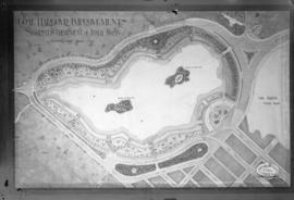
Coal Harbour Improvements Suggested Treatment of Inner Basin
![[English Bay after heavy snowfall]](/uploads/r/null/9/8/98d57e6aa43d81b764d660589019a9777086ef8ffa1ac5d9463a527dee1dbf26/46e3a80b-3931-459d-9c09-b1bd42694079-A16571_142.jpg)
[English Bay after heavy snowfall]
![[Avalon Harbour, Santa Catalina Island]](/uploads/r/null/f/2/f2184506a11e81a253d0060d8a571b077563283a65c7586fa8bcb09b39d573ba/505f7ee2-5ec3-4df1-99a1-32c291678ae4-CVA1477-519_142.jpg)
[Avalon Harbour, Santa Catalina Island]
![[Rock formations at Santa Catalina Island]](/uploads/r/null/a/9/a951f29913e1cc4c63593df0a41ebcbd331264fcd732603d85f88abdcbf78cd8/adc699c9-cdaa-4518-8685-553ed2add4de-CVA1477-518_142.jpg)
[Rock formations at Santa Catalina Island]
![[View of Avalon Harbor at Santa Catalina Island]](/uploads/r/null/d/f/df0c029ba2b136ed552f01672979bc7f99aa8f69654812e869a742485f26bd0f/b48b0662-55fd-4b82-804d-e4f46a0f75cb-CVA1477-512_142.jpg)
[View of Avalon Harbor at Santa Catalina Island]
![[View of Avalon Harbor at Santa Catalina Island]](/uploads/r/null/f/4/f4dd649d269242f020c71cefa964c09dda63a4e1aa7e8c19e7c0fc5486a37c15/c0e2a045-354a-422d-8c61-07d2f6d326fa-CVA1477-513_142.jpg)
[View of Avalon Harbor at Santa Catalina Island]

The "First Narrows" Entrance to Vancouver Harbour
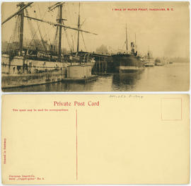
1 mile of water front, Vancouver, B.C.
![[Coal Harbour?]](/uploads/r/null/d/b/db2de6c93437b31527635deddfa2d1b0228f1dfd0d78c0bf6d754fd685fc663b/dccf9129-e23d-46e6-8e3f-0adde1d833b8-A16628_142.jpg)
[Coal Harbour?]
![[Coal Harbour?]](/uploads/r/null/1/0/10b1e3b62444e17b20e5c87b9cb37773568bcad1eb9f6ef2efd8c228b7f06408/5aa04f62-7a7b-4a73-a8bf-7920b9573446-A16631_142.jpg)
[Coal Harbour?]
![[Coal Harbour]](/uploads/r/null/7/7/77cafdf979fc613841ced240338b064a0d12d9e69c44cdbc458b83707b742e85/c32a0c26-2ba0-446c-bdac-ea9cff6ffa7a-A71815_142.jpg)
[Coal Harbour]
![Filling of government dock at Victoria, B.C. [Victoria outer dock]](/uploads/r/null/a/4/a407ab35e25717806ed19dee13e037e030e5e4a94cee438b0b27b6b923de43ce/82cdb86b-0638-46f6-8815-f9a538f91041-A31776_142.jpg)
Filling of government dock at Victoria, B.C. [Victoria outer dock]

The New Parliament Buildings, Victoria

Waterfront panorama - Vancouver harbour

Vancouver's waterfront
![[View of Burrard Inlet from Point Grey]](/uploads/r/null/e/3/e320d8072b352225b343a6bf036a24dfbe3d1f2d722001dd0b12d0aa899d36bb/bb12fe87-3475-4839-9e59-891393008d05-A64782_142.jpg)
[View of Burrard Inlet from Point Grey]
![Waterfront panorama [Vancouver harbour]](/uploads/r/null/f/f/fff7786f4bca4aa78e7d1b9180cc419e6a5caef59965491523e044f7bc9a9d33/7fcacbd0-7a6f-4056-8f98-9796bd0cc859-A02963_142.jpg)
Waterfront panorama [Vancouver harbour]
![[View of Burrard Inlet toward Howe Sound from Point Grey]](/uploads/r/null/d/7/d70841724af53c279a31c140bbc1fce42a0aa6a1d3a9c40cff087f263ccc345d/7095bde6-1c57-4e91-b87a-60bb6b7cd9f3-A64735_142.jpg)
[View of Burrard Inlet toward Howe Sound from Point Grey]

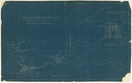
Map of the harbour of New Westminster, British Columbia
![[Coastal steamship] "Prince George" aground at 1st Narrows](/uploads/r/null/7/2/72c3f456be5f97334f1438b1e5d24a33f35c2e770793ebc9cd9f0f85ef9c3e41/323ecce2-b557-45f4-84eb-2d110852168f-A16207_142.jpg)
[Coastal steamship] "Prince George" aground at 1st Narrows
![N.P.A.A.O. [North Pacific Association of Amateur Oarsmen. One-man scull at] Esquimalt](/uploads/r/null/2/c/7/2c7a041f4573b48dfe710ad66ac640d7e95a4566083535aa2ed127c5268a1b18/931a73ba-3eb4-4564-9a85-04a72e883331-CVA7-318_142.jpg)
N.P.A.A.O. [North Pacific Association of Amateur Oarsmen. One-man scull at] Esquimalt