
Mount Pleasant School children's outdoor dance class
- AM1616-S1-: CVA 136-526
- Item
- Mar. 1940
Part of Pacific Press fonds
2373 results with digital objects Show results with digital objects
Mount Pleasant School children's outdoor dance class
Part of Pacific Press fonds

Mount Pleasant School children's outdoor dance class
Part of Pacific Press fonds

Electric railcars stored in barns above Old Mount Pleasant Beaver dam
Part of Pacific Press fonds

Man standing beside old granite trough in Mount Pleasant
Part of Pacific Press fonds

Part of Pacific Press fonds
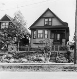
856 E 7th Ave with fences yard
856 E 7th Ave, Barb and Paddy on front porch
![856 E 7th Ave [taken] from road in front of house](/uploads/r/null/1/e/1/1e169ed63448aab64322b92f24f6a0030be4c303645c922538a70931ea5b0441/05d9134e-b168-4f4c-a951-ecbce0562b66-2018-034_142.jpg)
856 E 7th Ave [taken] from road in front of house
Item is a photograph showing houses along East 7th Avenue and two kids playing with a sled in the snow

City Hall, north facade from lawn
![[View of Squad Wagon car wreck at Broadway and Clark Drive]](/uploads/r/null/8/2/a/82ab696fadf8dde30e6d578856f855345436ca7aa6d9c320e1d3220e07da828c/2f3b92ed-11e0-4136-8f8b-72b3a516e0bf-CVA354-136_142.jpg)
[View of Squad Wagon car wreck at Broadway and Clark Drive]
Part of City of Vancouver fonds
Item is a photograph showing the car collision of Firehall No. 3 lnhalator involving firefighters Ken York, Don McLeod, Percy Richards, and Captain Oswald Howell (Howell later died in hospital).
![[View of Squad Wagon car wreck at Broadway and Clark Drive]](/uploads/r/null/a/b/e/abefc9ca8cbf8587fb0caa83d94b0f0b4c64e450ae0ca6207272d36866574fda/3fe5f23d-83c6-4800-bc44-6b43f2633542-CVA354-139_142.jpg)
[View of Squad Wagon car wreck at Broadway and Clark Drive]
Part of City of Vancouver fonds
Item is a photograph showing the car collision of Firehall No. 3 lnhalator involving firefighters Ken York, Don McLeod, Percy Richards, and Captain Oswald Howell (Howell later died in hospital).
![[View of Squad Wagon car wreck at Broadway and Clark Drive]](/uploads/r/null/5/3/c/53c679bd6f99951d4c75862b663159ab0baba7e015284b470f926373bd735b38/8216b509-f20a-4bec-8dcf-406c5f69ff32-CVA354-137_142.jpg)
[View of Squad Wagon car wreck at Broadway and Clark Drive]
Part of City of Vancouver fonds
Item is a photograph showing the car collision of Firehall No. 3 lnhalator involving firefighters Ken York, Don McLeod, Percy Richards, and Captain Oswald Howell (Howell later died in hospital).
Item is a photograph showing the former city landfill site at China Creek park area. Site no longer shows garbage and is covered over with dirt.
Item is a photograph showing the former city landfill site at China Creek park area. City crews are working on the fill site.
Item is a photograph showing the former city landfill site at China Creek park area. City crews are working on the fill site.
Broadway and Keith completed [garbage fill]
Item is a photograph showing the former landfill site covered over as a grass field.
Item is a photograph showing the former cycle track at Glen Drive and East 8th Avenue.
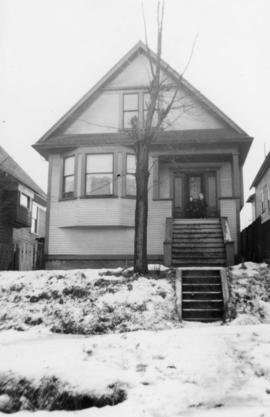
![[Exterior of cottage - 132 East 10th Avenue]](/uploads/r/null/d/a/da363db747ab1aba7b97718adc2c5f6dc97493f7f99bcba4b4bc75e4ccead30d/9cf0232e-6649-47da-bed1-e92c279a5dd8-A25026_142.jpg)
[Exterior of cottage - 132 East 10th Avenue]
Part of Major Matthews collection
Projects no. 1 and 2 maps and plans
Part of City of Vancouver fonds
File consists primarily of maps pertaining to redevelopment project 1, areas A and D, but also contains two maps from project 2. Maps include identification plans of property to be acquired; boundaries of clearance areas; general and detailed redevelopment plans; and maps showing the layout of existing and proposed utilities.
Part of City of Vancouver fonds
File consists of identification plans and redevelopment plans for project 2.

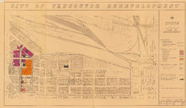
Project 2 area "h" and part of "b" : identification plan
Part of City of Vancouver fonds
Item is a map created to show the boundaries of redevelopment areas "b" and "h" in Project 2 and Project 2 clearance areas 8 & 9. The map also shows City-owned property, Adjacent lots in same ownership, as well as property, streets and lanes be acquired for the project. The portion of the City depicted in the map is the area between Main Street and Clark Drive and between Evans Avenue and 10th Avenue (D.L.200, D.L. 264A, D.L. 301, and D.L. 2037).
Part of City of Vancouver fonds
Item is a map showing boundaries of redevelopment and clearance areas, proposed land use, new streets and lanes, sites not to be acquired, and buildings to be retained in project 2. Map has been annotated with colour indicating land use and a proposed widening of Scotia Street. Base map shows building outlines and topographic contour lines, and covers the area bounded by Main Street, Clark Drive, Terminal Avenue, and Broadway

City of Vancouver redevelopment : project 2, area "H" and part of "B" : identification plan
Part of City of Vancouver fonds
Item is a map showing boundaries of clearance areas and ownership of property included in the acquisition program. Map has been annotated to show a possible amendment to the clearance area boundaries and a proposed widening of Scotia Street. Base map shows building outlines and topographic contour lines, and covers the area bounded by Main Street, Clark Drive, Terminal Avenue, and Broadway

Part of City of Vancouver fonds
Item is a map annotated to show the boundaries of Project no. 2 areas 8 and 9. Area 8 corresponds roughly to the area bounded by Scotia Street, Brunswick Street, 2nd Avenue, and 8th Avenue. Area 9 corresponds roughly to the area bounded by Guelph Street, Fraser Street, 5th Avenue, and 7th Avenue. Base map is a reproduction of an aerial photograph showing the area bounded by Main Street, Clark Drive, Terminal Avenue, and Broadway.

Project 2, area "h" and part of "b" : condition of buildings
Part of City of Vancouver fonds
Item is a map showing the condition of buildings (ranging from very good to very poor), the boundaries of redevelopment for areas "b" and "h" and the boundaries of project clearance for areas 8 and 9 for redevelopment proct 2.

Project 2, area "h" and part of "b" : existing gas, electricity and telephone
Part of City of Vancouver fonds
Item is a map showing the gas lines, the electricity lines, the telephone lines, the boundaries of redevelopment for areas "b" and "h" and the boundaries of project clearance for areas 8 and 9 in redevelopment project 2.

Project 2, area "h" and part of "b" : pavements, curbs and sidewalks
Part of City of Vancouver fonds
Item is a map showing the types of pavement, the curbs and gutters, the sidewalks, the boundaries of redevelopment for areas "b" and "h" and the boundaries of project clearance for areas 8 and 9 for redevelopment project 2.

Project 2, area "h" and part of "b" : existing utilities, water and sewer
Part of City of Vancouver fonds
Item is a map showing the water lines, the sewer lines, the direction of sewer flow, the boundaries of redevelopment for areas "b" and "h" and the boundaries of project clearance for areas 8 and 9 in redevelopment project 2.

Project 2, area "h" and part of "b" : plan of redevelopment
Part of City of Vancouver fonds
Item is a map showing boundaries of redevelopment areas "b" and "h", boundaries of project 2 clearance for areas 8 and 9, in project 2, proposed land use, new streets and lanes, sites in project 2 not to be acquired and buildings in project 2 to be retained.

Urban renewal scheme 3 : Mt. Pleasant 2 : apartment development
Part of City of Vancouver fonds
Item is a map annotated to show dates of construction of apartment buildings in the area bounded by Scotia Street, Clark Drive, Great Northern Way, and Broadway. Base map shows streets, building outlines, and topographical contour lines.

Urban renewal scheme 3 : Mt. Pleasant 2 : conditions of non-residential building
Part of City of Vancouver fonds
Item is a map annotated to show condition of non-residential buildings in the area bounded by Scotia Street, Clark Drive, Great Northern Way, and Broadway. Base map shows streets, building outlines, and topographical contour lines.

Urban renewal scheme 3 : Mt. Pleasant 2 : conditions of residential building
Part of City of Vancouver fonds
Item is a map annotated to show condition of residential buildings in the area bounded by Scotia Street, Clark Drive, Great Northern Way, and Broadway. Base map shows streets, building outlines, and topographical contour lines.

Urban renewal scheme 3 : Mt. Pleasant 2 : existing land use
Part of City of Vancouver fonds
Item is a map annotated to show types of land use in the area bounded by Scotia Street, Clark Drive, Great Northern Way, and Broadway. Base map shows streets, building outlines, and topographical contour lines.

Project 2, area "h" and part of "b" : condition of buildings
Part of City of Vancouver fonds
Item is a map showing the conditions of buildings (ranging from very good to very poor) in area "a" and part of area "b" in project 2. The map has been annotated to highlite part of the boundary around sub-area 9, as well as the southern portion of the sub-area. The significance of these annotations is not known.
![[Skateboard park]](/uploads/r/null/9/5/9500096098870fb8d827610ab03f141dd0bf01c45d617caa544e87f330285c6d/70798748-0df3-4d88-8398-cf1cc534a489-A69849_142.jpg)
Item is a photograph showing the China Creek Skateboard Park.
![[Skateboard park bowl with graffiti]](/uploads/r/null/9/8/988655418933e452c613bf63136ad3bced7f4aa2de6525d6350fc9c1c88a8ad8/7ce2f9c2-da0b-4c06-9a46-de2e79de5fe0-A69848_142.jpg)
[Skateboard park bowl with graffiti]
Item is a photograph showing the China Creek Skateboard Park.
![[Graffiti in skateboard park bowl]](/uploads/r/null/f/1/f1edc024e2a6493b3c3eb5d091615254658aa89cd13e3784d4858d7284800202/7422f33b-8992-4845-9abb-fb9f2ffdfbfa-A69850_142.jpg)
[Graffiti in skateboard park bowl]
Item is a photograph showing the China Creek Skateboard Park.
![[Man skateboarding in skateboard park bowl]](/uploads/r/null/b/5/b5b1290f2aa0ad5cb5f6665d543cdddf87044fc4c70666892e729e350cc012f2/2913a86f-6500-4f40-9ade-6a9cd00bfc19-A69851_142.jpg)
[Man skateboarding in skateboard park bowl]
Item is a photograph showing the China Creek Skateboard Park.
![[Man in skateboard park]](/uploads/r/null/4/2/42825094b7909809bd3150315bebd0809240a21156775068394125d8aad0caa6/03c777c5-aa38-425e-a6fa-d702443bad43-A69852_142.jpg)
Item is a photograph showing the China Creek Skateboard Park.
![[Children at wading pool in Jonathan Rogers Park]](/uploads/r/null/d/1/d1ed748a5fd4f49d8091e13289a79a4343b6b1b5ef3c5f8cc9b8e211d3afb99f/53ebf0c4-df3c-4b02-9dc9-4860673b268e-A69817_142.jpg)
[Children at wading pool in Jonathan Rogers Park]
![R.C.M.P. [Royal Canadian Mounted Police] Building, Main Street, clock tower detail](/uploads/r/null/4/7/8/4784077b86de352a04cf10904113237db0b62ab4b677e8244ec70993c8e4d32b/a94b914d-e305-45f2-8e7e-0bb76a62637e-CVA70-15_142.jpg)
R.C.M.P. [Royal Canadian Mounted Police] Building, Main Street, clock tower detail
Part of Art Grice fonds
Item is a photograph of the upper portion of the (northern) clock tower of the R.C.M.P. building (later, Heritage Hall, 3102 Main Street) at the corner of Main Street and 15th Avenue. The item details the clock face, tower roof, flag pole, lightning rods, and other architectural features.
![R.C.M.P. [Royal Canadian Mounted Police] Building, Main Street, west facade](/uploads/r/null/a/d/b/adbc09f89c670832271e75247cbd4dc4e4032bbb8407a3cad970b27809a0edf5/7a73d915-c683-494d-b735-78b65a7f1006-CVA70-16_142.jpg)
R.C.M.P. [Royal Canadian Mounted Police] Building, Main Street, west facade
Part of Art Grice fonds
Item is a photograph of the whole west (Main Street) facade of the R.C.M.P. building (later, Heritage Hall, 3102 Main Street) at the corner of Main Street and 15th Avenue. Both towers, entrances and all architectural features are visible.
Vancouver Cityscapes - Downtown, Fairview, Mount Pleasant
Part of City of Vancouver fonds
Item is a set of negatives of cityscape photographs taken mostly from the upper floors of the Plaza 500 Hotel & Convention Centre at 500 W. West 12th Avenue, at the intersection of West 12th Avenue and Cambie Street, looking north. The subject material of the photographs is predominantly downtown Vancouver, the North Shore Mountains, False Creek, and the Fairview and Mount Pleasant neighbourhoods. This set contains the raw photographs from the roll the photographer shot in their original order. The associated contact sheet has selection marks for frames 16, 21, 23, and 25.
![R.C.M.P. [Royal Canadian Mounted Police] Building, Main Street south entrance](/uploads/r/null/7/8/b/78bfd9357beddc228b5ad9726f607de307afa28829edd3a24c136b54b7882a16/ecded68b-962b-4fa7-a698-1c9b933fa643-CVA70-12_142.jpg)
R.C.M.P. [Royal Canadian Mounted Police] Building, Main Street south entrance
Part of Art Grice fonds
Item is a photograph of the secondary entrance of the R.C.M.P. building (later, Heritage Hall, 3102 Main Street) at the corner of Main Street and 15th Avenue showing a low angle view of the windows, ceiling, and architectural details above the doorway in the smaller southern tower. Also visible are some of the sculptures decorating the frieze above the second level.
![R.C.M.P. [Royal Canadian Mounted Police] Building, Main Street, north facade and clock tower](/uploads/r/null/f/1/3/f13b3c0d36643beee7d88d19a63a13b1aca3588fc2c2589a01baad7e2530b923/cc2920b3-3d9c-474d-b2c5-38619a59b10f-CVA70-13_142.jpg)
R.C.M.P. [Royal Canadian Mounted Police] Building, Main Street, north facade and clock tower
Part of Art Grice fonds
Item is a photograph of the (northern) clock tower, north facade, and frieze of the R.C.M.P. building (later, Heritage Hall, 3102 Main Street) at the corner of Main Street and 15th Avenue.
![R.C.M.P. [Royal Canadian Mounted Police] Building, Main Street, main entrance](/uploads/r/null/5/b/5/5b50e92503f01bd8a74fc5892f9f3708bb94bc9362fe91870501831f4d5c604c/10505865-147b-4588-98fc-e331a460607f-CVA70-14_142.jpg)
R.C.M.P. [Royal Canadian Mounted Police] Building, Main Street, main entrance
Part of Art Grice fonds
Item is a photograph of the main entrance of the R.C.M.P. building (later, Heritage Hall, 3102 Main Street) at the corner of Main Street and 15th Avenue showing the doorway, columns, windows, and architectural details above the main doorway. Also visible are some of the sculptures decorating the frieze above the second level.

Vancouver City Hall from the southwest
Part of City of Vancouver fonds
![[2636 Yukon Street, 2 of 2]](/uploads/r/null/c/1/2/c1271a1dbe52bebc929924cba80a1c00e7aad74a9c24c7a174f4bf33381a8d6e/ee204789-a9d0-4904-8c18-95500d739887-CVA1095-00271_142.jpg)
Part of City of Vancouver fonds
Item is a photograph that depicts an exterior view of 2636 Yukon St. taken from the intersection at West 11th Ave.
![[Lovers II sculpture, Vancouver City Hall]](/uploads/r/null/0/e/4/0e4e722c677a0ee8051d54c70a5e176b25c7ad83091cd7b87c72fb6267db6752/5f0a14df-b5a3-48c0-a28a-4e0f2332aa0d-CVA1095-00282_142.jpg)
[Lovers II sculpture, Vancouver City Hall]
Part of City of Vancouver fonds
Item is a photograph that depicts the sculpture Lovers II by Gerhard Juchum, located at City Hall, 453 West 12th Ave.
Mount Pleasant Housing Society financial statements