![[Back of] 818 - 826 Main Street](/uploads/r/null/2/b/2bc994c70b7ed51271c77148769e11f13913840e237de9342f1f5476fe0b4a55/6d87d840-1720-40f5-af91-6194ad666a89-A59008_142.jpg)
[Back of] 818 - 826 Main Street
- COV-S168---: CVA 203-15
- Item
- 1970
Part of City of Vancouver fonds
[Back of] 818 - 826 Main Street
Part of City of Vancouver fonds
![828 - 830 Main Street [front]](/uploads/r/null/c/3/c3ec6372cb389b3f3002c40f07cf10a993fac41b82b0fea413bb9122c4bde6a3/ad6b48d3-1cdc-4083-bc05-61a3898c2f3d-A59009_142.jpg)
Part of City of Vancouver fonds
Photograph shows 3 Vets (830 Main Street and 832 Main Street).
![[Back of] 832 Main Street](/uploads/r/null/0/a/0a4ed0ac5fc8779c15083c3723c1a92ec53b82bfab780b771401613661641094/c4f99030-e1c4-4651-9010-0abd9aa0856b-A59012_142.jpg)
Part of City of Vancouver fonds
Photograph shows 3 Vets War Surplus store.
![237 Prior Street [front]](/uploads/r/null/c/6/c6c9a905d4a3087d7e5ac2a11727c63652365242163606c076b0780d773b91c7/3630d6b8-c919-42e2-afa1-83f9eb8e32fb-A59013_142.jpg)
Part of City of Vancouver fonds
![249 Prior Street [front]](/uploads/r/null/a/0/a042bf2d60777bd44837fabfa480ad11e21186abed4df74e154555ab5fdd6264/e05f1807-ec02-4547-93b4-a3976498e093-A59015_142.jpg)
Part of City of Vancouver fonds
Photograph shows Don Huish Interiors sign.
![259 Prior Street [Chou Doely Gam cabins front]](/uploads/r/null/c/4/c4dfbcbda5cfa1bb1f5e80a4da2ccfca8742d7a0bd74f845c5039760322962d1/84bddb40-670d-44a8-b81b-ba105f93aa6a-A59021_142.jpg)
259 Prior Street [Chou Doely Gam cabins front]
Part of City of Vancouver fonds
200 block Prior Street N/S and 200 block Union Street S/S
Part of City of Vancouver fonds
![224 Union Street [back]](/uploads/r/null/0/9/097cf00086d2c3783c04485d0c3d9a3c8d658e3cbd8531ac48817ebf394a3b4e/fa680b57-04cd-4a33-b83d-6fb093403d87-A59032_142.jpg)
Part of City of Vancouver fonds
Photograph also shows portion of 218 Union Street.
![226 Union Street [front]](/uploads/r/null/8/8/8842e2123ba538de2aa547a15081ed78738fbb6edefcecc8615b250ce9fcd725/5ff10bf2-82bc-47ea-bbad-830a6a20e82b-A59033_142.jpg)
Part of City of Vancouver fonds
![226 Union Street [back]](/uploads/r/null/8/4/84fa1b5ddd666c3c6d9426ed5885795fa28e585fda16f06535664a11f8b7be0a/bcfb75f7-cac1-4675-a4b9-47dca5998510-A59034_142.jpg)
Part of City of Vancouver fonds
![264 Union Street [front]](/uploads/r/null/b/3/b3478c612ceb9d033b16ed09e2f52a1dd8f2cb29520e9cc4ad527a9d217b189b/01e220c4-d656-4042-8d3a-69114b290c7d-A59042_142.jpg)
Part of City of Vancouver fonds
Photograph also shows part of 268 Union Street.
![[Western Assembly Ltd. shed, 94 West Pender Street (rear)]](/uploads/r/null/f/9/f95f7aba035edf4d5afeb10c133ce3cdd0f7a4521fcdaaa5290bcbc76dbeb60d/4046eb74-bce3-4733-9056-7b8fa52b0d34-A59066_142.jpg)
[Western Assembly Ltd. shed, 94 West Pender Street (rear)]
Part of City of Vancouver fonds
![[Western Assembly Ltd. shed, 94 West Pender Street (rear)]](/uploads/r/null/3/4/34b5f4a263d5c309c616cd7d2abf02376fe515fe00ed297748ea44a85c0afe32/f4855238-e473-44d7-906f-3e3f59095040-A59070_142.jpg)
[Western Assembly Ltd. shed, 94 West Pender Street (rear)]
Part of City of Vancouver fonds

McDonald Cedar Products (piers G17 to G19)
Part of City of Vancouver fonds

McDonald Cedar Products (piers G17 to G19)
Part of City of Vancouver fonds
![Rear and west side view of building [219 - 221 Prior Street]](/uploads/r/null/2/7/27ba93d2aef133420c8631082e747e51c5c23273430afd0dbe124a406558da82/8cf1a45a-fd1d-48f3-98bd-f26fad39ad22-A59059_142.jpg)
Rear and west side view of building [219 - 221 Prior Street]
Part of City of Vancouver fonds
![Subject [Iberica Garage and Northland Cafe 219 - 221 Prior Street] as seen looking northwest acro...](/uploads/r/null/5/9/59c867778a549c53cb33629eccef332aa2ec108aee392ce359d8ccbf0353b000/cd57f892-bc00-478d-bb0b-f8a4d50338ff-A59060_142.jpg)
Part of City of Vancouver fonds
![[219 and] 221 Prior Street](/uploads/r/null/b/0/b045e3b739fb000f7ef729743a67e781a07dc8a74ba86808e23fc0db4f7aed18/d597b9dd-ddf4-4c9d-8494-c98bc24b1cc2-A59046_142.jpg)
Part of City of Vancouver fonds
Photograph shows the Iberica Garage and the Northland Cafe
![[219 and] 221 Prior Street](/uploads/r/null/1/6/16519d39f4c06087f60b1270989ec7b655ab61d7a350c02f2eb1546580b0d0ea/bb4e4d5f-e46e-4f9a-bbfd-c58be37656de-A59047_142.jpg)
Part of City of Vancouver fonds
Photograph shows the Iberica Garage and the Northland Cafe
![[219 and] 221 Prior Street [back view of the Iberica Garage and the Northland Cafe]](/uploads/r/null/2/2/2222e00535a17f88b2e1e591a9bae8c13d37d8ded5391080a8f0316afd4edd3a/2757dd36-2905-42d4-a78c-173cfc9a3e22-A59048_142.jpg)
[219 and] 221 Prior Street [back view of the Iberica Garage and the Northland Cafe]
Part of City of Vancouver fonds
![[219 and] 221 Prior Street](/uploads/r/null/c/d/cd282c2bf7b2f0067fa876724b323da0f28efab180af2a1e6e5ff4889fa7a07b/6913f428-7a6b-4ed7-baa8-d2a0dc3d6467-A59049_142.jpg)
Part of City of Vancouver fonds
Photograph shows the Iberica Garage and the Northland Cafe

Partial view of shoreline from Burrard Bridge
Part of City of Vancouver fonds
Item is a photograph showing a partial view looking down on shoreline from Burrard Bridge at the foot of Beach Avenue on east side of Burrard Bridge.

View of boats and debris under Burrard Bridge
Part of City of Vancouver fonds
Item is a photograph showing a cluster of boats, sheds and debris at the foot of Beach avenue, taken from Burrard Bridge.

Sewage : area bounded by Joyce Street, Boundary Road, Wellington Avenue and Kingsway
Part of City of Vancouver fonds

Plan of district lot boundaries, City of Vancouver, B.C.
Part of City of Vancouver fonds
Item is a map of Vancouver showing district lot boundaries.
The map identifies First Nations reserves, the University Endowment Lands, Stanley Park, Old Granville Townsite and Hastings Townsite. On the verso of the map is a legend indicating the colours used on the maps in this file to define areas of tax sale property for sale, no water, street widening - drainage, replotting, reserved school, reserved park, sundry, capital assets (except schools and parks), schools, and parks.
Vancouver (B.C.). Office of the City Engineer

Sheet 10 : Clark Drive to Slocan Street and Burrard Inlet to Triumph Street
Part of City of Vancouver fonds
Item is a section showing the area from Clark Drive to Slocan Street and aterfront to Triumph Street. Includes streets and roads, blocks, lots, legal descriptions, railways, parks, boys' detention home and businesses along the waterfront. The Town of Hastings is indicated on the map. Map is hand coloured to show tax sale property for sale, property with no water, street widening and drainage, replotting, reserved land for schools, reserved land for parks, sundry land, capital assets not including schools and parks, schools, and parks, as applicable.
Vancouver (B.C.). Office of the City Engineer

Sheet 8 : McLean Drive to Slocan Street and William Street to Seventh Avenue
Part of City of Vancouver fonds
Item is a section showing the area from McLean Drive to Slocan Street and William Street to Seventh Avenue. Includes streets and roads, blocks, lots, legal descriptions, railways, parks, schools and some businesses. Map is hand coloured to show tax sale property for sale, property with no water, street widening and drainage, replotting, reserved land for schools, reserved land for parks, sundry land, capital assets not including schools and parks, schools, and parks, as applicable. Some annotations have been made in pencil.
Vancouver (B.C.). Office of the City Engineer

Sheet 16 : Maple Street to Oak Street and False Creek to Sixteenth Avenue
Part of City of Vancouver fonds
Item is a section showing Maple Street to Oak Street and False Creek to Sixteenth Avenue. Includes streets and roads, blocks, lots, legal descriptions, railways, schools and parks. Indicates crown land leased to the C.P.R. and other bodies. Map is hand coloured to show tax sale property for sale, property with no water, street widening and drainage, replotting, reserved land for schools, reserved land for parks, sundry land, capital assets not including schools and parks, schools, and parks.
Vancouver (B.C.). Office of the City Engineer

Sheet 18 : Trutch Street to Maple Street and English Bay to Third Avenue
Part of City of Vancouver fonds
Item is a section showing Trutch Street to Maple Street and English Bay to Third Avenue. Includes streets, roads, blocks, lots, legal descriptions, parks and crown grants. Map is hand coloured to show tax sale property for sale, property with no water, street widening and drainage, replotting, reserved land for schools, reserved land for parks, sundry land, capital assets not including schools and parks, schools, and parks.
Vancouver (B.C.). Office of the City Engineer

Sheet 21 : Burrard Street to False Creek and waterfront to Robson Street
Part of City of Vancouver fonds
Item is a section showing Burrard Street to False Creek and waterfront to Robson Street. Includes streets and roads; blocks, lots and legal descriptions; the locations of hotels, court house, businesses, parks, and schools; crown leases; C.P.R. land and the company's Piers B and C, yards, sheds and depot; the B.C. Electric Railway Carrall Street Yard; and the Union Steamship Company. Map is hand coloured to show tax sale property for sale, property with no water, street widening and drainage, replotting, reserved land for schools, reserved land for parks, sundry land, capital assets not including schools and parks, schools, and parks, as applicable.
Vancouver (B.C.). Office of the City Engineer

Sheet 6 : Knight Street to Slocan Street and Eighteenth Avenue to Twenty-ninth Avenue
Part of City of Vancouver fonds
Item is a section showing the area from Knight Street to Slocan Street and Eighteenth Avenue to Twenty-ninth Avenue. Includes streets and roads, blocks, lots, legal descriptions, railways, parks and schools. Some annotations have been made in pencil. Map is hand coloured to show tax sale property for sale, property with no water, street widening and drainage, replotting, reserved land for schools, reserved land for parks, sundry land, capital assets not including schools and parks, schools, and parks. Map is hand coloured to show tax sale property for sale, property with no water, street widening and drainage, replotting, reserved land for schools, reserved land for parks, sundry land, capital assets not including schools and parks, schools, and parks, as applicable.
Vancouver (B.C.). Office of the City Engineer

Sheet D : Imperial Street to Trutch Street and Fourth Avenue to Sixteenth Avenue
Part of City of Vancouver fonds
Item is a section showing the area from Imperial Street to Trutch Street and Fourth Avenue to Sixteenth Avenue. Includes streets and roads; blocks; lots and legal descriptions; and parks, schools and golf courses. Section is annotated to show tax sale property for sale, property with no water, street widening and drainage, replotting, reserved land for schools, reserved land for parks, sundry land, capital assets not including schools and parks, schools, and parks, as applicable.
Vancouver (B.C.). Office of the City Engineer

Sheet G : Trafalgar Street to Granville Street and Sixteenth Avenue to Nanton Avenue
Part of City of Vancouver fonds
Item is a section showing the area from Trafalgar Street to Granville Street and Sixteenth Avenue to Nanton Avenue. Includes streets, roads and sewers; blocks, lots and legal descriptions; and parks, railway lines and schools. Section is annotated to show tax sale property for sale, property with no water, street widening and drainage, replotting, reserved land for schools, reserved land for parks, sundry land, capital assets not including schools and parks, schools, and parks, as applicable.
Vancouver (B.C.). Office of the City Engineer

Sheet O : Holland Street to Elm Street and Thirty-eighth Avenue to Forty-ninth Avenue
Part of City of Vancouver fonds
Item is a section showing the area from Holland Street to Elm Street and Thirty-eighth Avenue to Forty-ninth Avenue. Includes streets, roads and sewers; blocks, lots and legal descriptions; and golf courses, parks and schools. Map is hand coloured to show tax sale property for sale, property with no water, street widening and drainage, replotting, reserved land for schools, reserved land for parks, sundry land, capital assets not including schools and parks, schools, and parks, as applicable.
Vancouver (B.C.). Office of the City Engineer

Sheet T : Marine Crescent to Granville Street and Forty-ninth Avenue to Sixty-first Avenue
Part of City of Vancouver fonds
Item is a section showing the area from Marine Crescent to Granville Street and Forty-ninth Avenue to Sixty-first Avenue. Includes streets and roads; blocks, lots and legal descriptions; and parks and golf courses. Map is hand coloured to show tax sale property for sale, property with no water, street widening and drainage, replotting, reserved land for schools, reserved land for parks, sundry land, capital assets not including schools and parks, schools, and parks, as applicable.
Vancouver (B.C.). Office of the City Engineer

Sheet X : Marine Drive to Ash Street and Fifty-ninth Avenue to Seventy-first Avenue
Part of City of Vancouver fonds
Item is a section showing the area from Marine Drive to Ash Street and Fifty-ninth Avenue to Seventy-first Avenue. Includes streets and roads; blocks, lots and legal descriptions; and parks and schools. Map is hand coloured to show tax sale property for sale, property with no water, street widening and drainage, replotting, reserved land for schools, reserved land for parks, sundry land, capital assets not including schools and parks, schools, and parks, as applicable.

Sheet 6 : Craddock Street to Boundary Road and Twenty-ninth Avenue to Fortieth Avenue
Part of City of Vancouver fonds
Item is a section showing the area from Craddock Street to Boundary Road and Twenty-ninth Avenue to Fortieth Avenue. Includes streets, roads, blocks, lots, legal descriptions, parks. railway lines and schools. Map is hand coloured to show tax sale property for sale, property with no water, street widening and drainage, replotting, reserved land for schools, reserved land for parks, sundry land, capital assets not including schools and parks, schools, and parks, as applicable.
Vancouver (B.C.). Office of the City Engineer

Sheet 3 : Cambie Street to St. George Street and Twenty-seventh Avenue to Thirty-eighth Avenue
Part of City of Vancouver fonds
Item is a section showing the area from Cambie Street to St. George Street and Twenty-seventh Avenue to Thirty-eighth Avenue. Map shows streets, roads, blocks, lots and legal descriptions and the locations of parks, schools, reservoirs and Mountainview Cemetery. Map is hand coloured to show tax sale property for sale, property with no water, street widening and drainage, replotting, reserved land for schools, reserved land for parks, sundry land, capital assets not including schools and parks, schools, and parks, as applicable.
Vancouver (B.C.). Office of the City Engineer

Sheet 13 : Fleming Street to Carlton Street and Forty-seventh Avenue to Fifty-ninth Avenue
Part of City of Vancouver fonds
Item is a section showing the area from Fleming Street to Carlton Street and Forty-seventh Avenue to Fifty-ninth Avenue. Includes streets, roads, blocks, lots, legal descriptions, parks and schools. Map is hand coloured to show tax sale property for sale, property with no water, street widening and drainage, replotting, reserved land for schools, reserved land for parks, sundry land, capital assets not including schools and parks, schools, and parks, as applicable.
Vancouver (B.C.). Office of the City Engineer

Sheet 11 : Cambie Street to St. George Street and Forty-seventh Avenue to Fifty-eighth Avenue
Part of City of Vancouver fonds
Item is a section showing the area from Cambie Street to St. George Street and Forty-seventh Avenue to Fifty-eighth Avenue. Includes streets, roads, blocks, lots, legal descriptions, golf courses, parks and schools. Map is hand coloured to show tax sale property for sale, property with no water, street widening and drainage, replotting, reserved land for schools, reserved land for parks, sundry land, capital assets not including schools and parks, schools, and parks, as applicable.
Vancouver (B.C.). Office of the City Engineer

Sheet 9 : Fleming Street to Carlton Street and Thirty-seventh Avenue to Forty-eighth Avenue
Part of City of Vancouver fonds
Item is a section showing the area from Fleming Street to Carlton Street and Thirty-seventh Avenue to Forty-eighth Avenue. Includes streets, roads, blocks, lots, legal descriptions, parks and schools. Map is hand coloured to show tax sale property for sale, property with no water, street widening and drainage, replotting, reserved land for schools, reserved land for parks, sundry land, capital assets not including schools and parks, schools, and parks, as applicable.
Vancouver (B.C.). Office of the City Engineer

City of Vancouver redevelopment : project 1 : generalized plan of redevelopment
Part of City of Vancouver fonds
Item is a map showing boundaries of the comprehensive redevelopment plan and the Project 1 clearance areas, and the proposed street system and land use. Base map shows streets and legal addresses for Vancouver from Yew Street to Templeton Drive and Burrard Inlet to 15th Avenue.
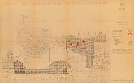

Frank Jones, Commissioner 1956-1958
Part of City of Vancouver fonds
![2409 Main Street [F.W. Woolworth Co.]](/uploads/r/null/5/c/1/5c182ddd1b224ad36b6d4f9a7583c1e06c1d4e9285d4a9894429c399380c5bfe/1998be35-c0d5-44ef-9e62-48d7f21e39b1-CVA332-25_142.jpg)
2409 Main Street [F.W. Woolworth Co.]
Part of City of Vancouver fonds
Photograph shows street banners.
![2409 Main Street [F.W. Woolworth Co.]](/uploads/r/null/f/d/f/fdfdaab03f8fc2d005116b0dd3377d6a2c57a4c3edd0de77d2ca93074889c65a/df886338-9dc6-4d85-997e-68d6b0aed5c9-CVA332-26_142.jpg)
2409 Main Street [F.W. Woolworth Co.]
Part of City of Vancouver fonds

The Fat Cat and The Boiler Room
Part of City of Vancouver fonds
Item part is a photograph of a sidewalk scene on Powell Street looking north towards Maple Tree Square, Gastown. Signage for The Fat Cat and The Boiler Room are visible in the foreground, and Guenter's Delicatessen (203 Carrall Street) is visible in the background.

Sidewalk scene, Powell Street near Maple Tree Square, Gastown
Part of City of Vancouver fonds

Part of City of Vancouver fonds
Item part is a photograph of the storefront of Guenter's Delicatessen (203 Carrall Street) from Maple Tree Square, Gastown.

The Quest, Gassy Jack's Place, and Vancouver Supply Company Ltd.
Part of City of Vancouver fonds
Item part is a photograph of a street scene at Maple Tree Square, Gastown, looking northeast down Alexander Street The Quest (Quest Team Three design projects Ltd., 1 Alexander Street), Gassy Jack's Place, and Vancouver Supply Company Ltd. (25 Alexander Street) storefronts are visible in the background, with moving pedestrians blurred in the foreground.