![[Mills on False Creek]](/uploads/r/null/4/8/484464a7c6f3891c53e9dd53b67dd525cb39f96f5cbfd54b3910d5eaf5b30721/e75a48e1-1600-419a-a572-9e268c856b75-A75566_142.jpg)
- AM640-S1-: CVA 260-547
- Item
- 1936
Part of James Crookall fonds
Part of James Crookall fonds
![[View of mills on False Creek]](/uploads/r/null/6/0/60c76f77e7169fdad44d17b5ebbd6721a4becd3d7bd40b79373aadb73ccd4506/d6aac711-c905-4e3d-9507-9f22799668a1-A75580_142.jpg)
[View of mills on False Creek]
Part of James Crookall fonds
![[View of mills on False Creek]](/uploads/r/null/e/e/ee7ace74b178d2e25073b8d03d95b4054aa7a8db8bbf7c7bb3c6f938a2011bef/98045123-1f0a-4785-9c21-87f645c45b1b-A75581_142.jpg)
[View of mills on False Creek]
Part of James Crookall fonds
![[View of mills on False Creek]](/uploads/r/null/1/3/139c96ee1a7ea161c6fcccaf9a399e3a2d2c03de93eea7241144e4a489b9d928/8310b49e-6ded-4607-8757-e93c6d58345f-A75582_142.jpg)
[View of mills on False Creek]
Part of James Crookall fonds
![[View of mills on False Creek]](/uploads/r/null/0/b/0be27bc58a5e995b0e07ae9e8d4aed255c9276ab84aea047777e1c931b3b5a16/6186ab3c-0182-43a5-9672-b52bb065ce06-A75583_142.jpg)
[View of mills on False Creek]
Part of James Crookall fonds
![[Log booms in False Creek]](/uploads/r/null/d/6/d66bf9825d215a378290e2cdb75e697f851b0f7f7b12a14693642c26e4b6ef87/c3722fd7-333e-4294-91fc-6da49d432621-A75586_142.jpg)
Part of James Crookall fonds
![[Log booms in False Creek]](/uploads/r/null/4/7/4773cc1ae813502c81a6cda0d2de46e4b70e67b816dd2c8c7b059fa4163911cc/d30dc4fe-d5ce-4180-8ef4-1c471f75a52b-A75587_142.jpg)
Part of James Crookall fonds
![[Log booms in False Creek]](/uploads/r/null/f/5/f550243b860a51f5ec457cf274b2623c13752319dd5a319f265dbf61ceadaa21/6ce86de1-00d0-4811-8f36-44264d095e99-A75588_142.jpg)
Part of James Crookall fonds
![[View of mills and log booms on False Creek]](/uploads/r/null/a/b/ab1593edb185df4255c1c79e284efa1c6336e23445a988a01beab74cbfbfc3e1/7d0c0bdd-c2ae-4ab5-8d8d-47f8f61c8a2d-A75591_142.jpg)
[View of mills and log booms on False Creek]
Part of James Crookall fonds
Photograph shows the Vancouver Lumber Company smoke stack
![[View of mills on False Creek]](/uploads/r/null/1/1/1152bc42dd7c07368e8860afd94f1af23da3eb5d459055474639e164a71b802a/c2fefbe7-e24f-4e36-a7e8-a6a580a6f42d-A75592_142.jpg)
[View of mills on False Creek]
Part of James Crookall fonds
![False Creek w[ith] Mount Pleasant and Fairview Slopes in background](/uploads/r/null/0/0/00add1c74f2062cb2fe3f05597058b1fdf56f63cf4bc40d94e1355ae82a9de76/26527591-1d64-4917-b0a8-16b0c03c3071-A59349_142.jpg)
False Creek w[ith] Mount Pleasant and Fairview Slopes in background
Part of City of Vancouver fonds
Photograph also shows a sawmill along False Creek and the Vancouver City Hall (453 West 12th Avenue) in Fairview
![[View of Downtown from the Vancouver Iron and Engineering Works Ltd. at 1155 West 6th Avenue]](/uploads/r/null/3/1/318625c5a9ad983f92e59fa31c7055a196f7feb179dd8dffcedae145a36c5cc5/52732964-6835-4d57-9a91-a7816c96cea0-A59350_142.jpg)
[View of Downtown from the Vancouver Iron and Engineering Works Ltd. at 1155 West 6th Avenue]
Part of City of Vancouver fonds
![Vancouver Iron [and Engineering] Works [Ltd. at 1155 West 6th Avenue]](/uploads/r/null/e/6/e6a863f6dac21b50be8367e8e5750691baffa19601e5c20b94bf689cebc0c652/bef90d24-f0c4-4d0d-b5fc-0b7d2650917e-A59351_142.jpg)
Vancouver Iron [and Engineering] Works [Ltd. at 1155 West 6th Avenue]
Part of City of Vancouver fonds
![[Sawmill on False Creek]](/uploads/r/null/b/0/b04708c4560b430def4212011e68117acb07b38eb56843a46386f7b1d7a89497/f2d44c33-8e99-472c-8a72-7accb5e8ee56-A59353_142.jpg)
Part of City of Vancouver fonds
![Sweeney Cooperage [Ltd.]](/uploads/r/null/3/e/3e7df79a73f3552787b2ac8a56721336248cde70ec43b3805c3d4ef95fac37be/a26dc3db-7c95-4350-ba74-fd154c1e8ffd-A59354_142.jpg)
Part of City of Vancouver fonds
Photograph also shows the Sun Tower (100 West Pender Street) and the Dominion Building (207 West Hastings Street)
![Vancouver Iron [and Engineering] Works [Ltd. at 1155 West 6th Avenue]](/uploads/r/null/6/b/6be9697c52433ad1920fd5e29cb57959e27c9ecca3baa1946998a8ac3bce7fa1/6627b3c4-5254-4eae-b655-7375303a79e4-A59355_142.jpg)
Vancouver Iron [and Engineering] Works [Ltd. at 1155 West 6th Avenue]
Part of City of Vancouver fonds
Photograph also shows the Granville Bridge

Part of City of Vancouver fonds
Photograph shows the area under construction
![East False Creek - view of Main [Street] and Terminal [Avenue] development site](/uploads/r/null/7/2/7288d98a41b178fa9ee107e1e999c2616b8abf7036567e77c13137c80b01bbff/5884a45a-b3fe-4d62-b82f-2f565f3ab7ff-A59358_142.jpg)
East False Creek - view of Main [Street] and Terminal [Avenue] development site
Part of City of Vancouver fonds

False Creek East End - Lafarge Cement mixing tower
Part of City of Vancouver fonds

Part of City of Vancouver fonds
Photograph also shows buildings downtown including the Harbour Centre (555 West Hastings Street)
![[Apartment buildings along False Creek]](/uploads/r/null/b/2/b209ef93abe272321bc4a3fe61d2a2381b14d1dfa34ebbcbacf86c2649da0452/47895e1b-702d-4f8a-8227-29f2097dd8e1-A59362_142.jpg)
[Apartment buildings along False Creek]
Part of City of Vancouver fonds
![[False Creek] Flats](/uploads/r/null/e/7/e7450a812769b734fdb630c5682f8f9801cecaf5cad224fe8b3d9bc314d812bf/5c2ed294-8765-473d-b7bc-ad4984bfdbac-A59365_142.jpg)
Part of City of Vancouver fonds
Photograph also shows a railroad yard
![[False Creek Flats]](/uploads/r/null/1/9/19db44d96123806a1b4bd574dc111b4b2c79200dfb9d5803f2f17a1c2d510e61/b3c2dad7-4db2-43bc-9516-7a6d9eb9735d-A59366_142.jpg)
Part of City of Vancouver fonds
![[False Creek] Flats from 6th [Avenue] and Fraser [Street]](/uploads/r/null/2/7/27e847eba4ebf46a9ac9901a2dd1547ced0e767e8f28c885e7a295b765d95871/db1de25a-e791-4065-a2b9-1ef2ccbbe087-A59367_142.jpg)
[False Creek] Flats from 6th [Avenue] and Fraser [Street]
Part of City of Vancouver fonds
Photograph shows a railroad yard

Part of City of Vancouver fonds
Photograph also shows the Canadian National Railway Station (1150 Station Street)
![[Northeast view of False Creek]](/uploads/r/null/c/b/cb30fde9722b8b64fd3b7e25f7487dfe9b743e7495319068d8ee15205635a8d1/982986e0-014c-4224-a34c-78e2d1d69b3f-A59369_142.jpg)
[Northeast view of False Creek]
Part of City of Vancouver fonds

Part of City of Vancouver fonds
Photograph also shows Science World (1455 Quebec Street) during construction
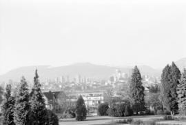
Downtown view over Fairview neighborhood
Part of City of Vancouver fonds
Item part is a photograph of the top of the downtown Vancouver skyline over the trees of a Fairview neighborhood. This photograph was taken from one of the lower floors of the Plaza 500 Hotel & Convention Centre.

Downtown view over Fairview neighborhood
Part of City of Vancouver fonds
Item part is a photograph of the top of the downtown Vancouver skyline over the trees of a Fairview neighborhood. This photograph was taken from one of the lower floors of the Plaza 500 Hotel & Convention Centre.

Downtown view over Fairview neighborhood
Part of City of Vancouver fonds
Item part is a photograph of the top of the downtown Vancouver skyline over the trees of a Fairview neighborhood. This photograph was taken from one of the lower floors of the Plaza 500 Hotel & Convention Centre.

Downtown cityscape over Mount Pleasant and False Creek
Part of City of Vancouver fonds

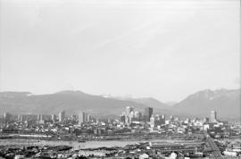
Downtown cityscape over Mount Pleasant, Fairview, and False Creek
Part of City of Vancouver fonds
Item part is a photograph of downtown Vancouver, including a view down Cambie Street across the Cambie Street Bridge, and adjacent neighborhoods in Fairview and Mount Pleasant.

Downtown cityscape over Mount Pleasant, Fairview, and False Creek
Part of City of Vancouver fonds
Item part is a photograph of downtown Vancouver, including a view down Cambie Street across the Cambie Street Bridge, and adjacent neighborhoods in Fairview and Mount Pleasant.

Downtown cityscape over Fairview, and False Creek
Part of City of Vancouver fonds

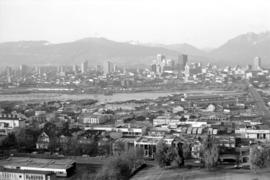
Downtown cityscape over Mount Pleasant, Fairview, and False Creek
Part of City of Vancouver fonds
Item part is a photograph of downtown Vancouver, including a view down Cambie Street across the Cambie Street Bridge, and adjacent neighborhoods in Fairview and Mount Pleasant.
Downtown cityscape over Mount Pleasant, Fairview, and False Creek
Part of City of Vancouver fonds
Item part is a photograph of downtown Vancouver, including a view down Cambie Street across the Cambie Street Bridge, and adjacent neighborhoods in Fairview and Mount Pleasant.

Downtown cityscape over Fairview, and False Creek
Part of City of Vancouver fonds

Downtown cityscape over Mount Pleasant, Fairview, and False Creek
Part of City of Vancouver fonds
Item part is a photograph of downtown Vancouver, including a view down Cambie Street across the Cambie Street Bridge, and adjacent neighborhoods in Fairview and Mount Pleasant. The Granville Street Bridge and the Burrard Street Bridge are visible at the far left.

Downtown cityscape over Mount Pleasant, Fairview, and False Creek
Part of City of Vancouver fonds
Item part is a photograph of downtown Vancouver, including a view down Cambie Street across the Cambie Street Bridge, and adjacent neighborhoods in Fairview and Mount Pleasant.

Downtown cityscape over Mount Pleasant, Fairview, and False Creek
Part of City of Vancouver fonds
Item part is a photograph of downtown Vancouver, including a view down Cambie Street across the Cambie Street Bridge, and adjacent neighborhoods in Fairview and Mount Pleasant.
Downtown cityscape over Mount Pleasant, Fairview, and False Creek
Part of City of Vancouver fonds
Item part is a photograph of downtown Vancouver, including a view down Cambie Street across the Cambie Street Bridge, and adjacent neighborhoods in Fairview and Mount Pleasant.

Downtown cityscape over Mount Pleasant, Fairview, and False Creek
Part of City of Vancouver fonds
Item part is a photograph of downtown Vancouver, including a view down Cambie Street across the Cambie Street Bridge, and adjacent neighborhoods in Fairview and Mount Pleasant.

Downtown cityscape over Mount Pleasant, Fairview, and False Creek
Part of City of Vancouver fonds
Item part is a photograph of downtown Vancouver, including a view down Cambie Street across the Cambie Street Bridge, and adjacent neighborhoods in Fairview and Mount Pleasant.

Downtown cityscape over Fairview and False Creek
Part of City of Vancouver fonds
Item part is a photograph of downtown Vancouver over Fairview and False Creek. The Granville Street Bridge and the Burrard Street Bridge are visible at the far left.
![False Creek [1 of 606]](/uploads/r/null/7/a/7aa52413a19096ac311347558283a0e89637f2a3ae50deedfd4c8adc158af9b8/bc85f12e-03f8-417c-872d-d8fcc689e097-A64107_142.jpg)
Part of City of Vancouver fonds
![False Creek [2 of 606]](/uploads/r/null/6/c/6c8d91ce69c8127a88057855b63c662efc8bd539f3067d15493c28db5c52a743/e7ac5152-1ea2-4ffd-a9fc-539d1e62e96d-A64108_142.jpg)
Part of City of Vancouver fonds
![False Creek [3 of 606]](/uploads/r/null/8/b/8be4aa01f76edf95357b21e0e5ee2c3285f2b51ff8926bb8438fcf90418108c9/ecc1a1da-cd67-4001-93ac-25fdd3160795-A64116_142.jpg)
Part of City of Vancouver fonds
![False Creek [4 of 606]](/uploads/r/null/f/4/f4008ed779aabcbd2aa3354f9bf520f444a23aae2881db097596b4446559a27e/776a9f7c-382f-474c-aa2f-e757bcb1c0aa-A64117_142.jpg)
Part of City of Vancouver fonds