![[Charles W. Cates standing beside the achor of the S.S. "Beaver"]](/uploads/r/null/7/9/79769ad3e2804ed9aaeada1eea3a33066ad3dcd5a243050ea2ab77b0b1166012/a08bc7d0-4be2-4cee-bf40-35969a637ea7-A61799_142.jpg)
[Charles W. Cates standing beside the achor of the S.S. "Beaver"]
- AM54-S4-2-: CVA 371-1549
- Item
- Oct. 10, 1957
Part of Major Matthews collection
703 results with digital objects Show results with digital objects
[Charles W. Cates standing beside the achor of the S.S. "Beaver"]
Part of Major Matthews collection
![[Bliss Carman on Grouse Mountain]](/uploads/r/null/e/2/e2a44d009ec03020075369229d0fb8836c49b4d3d20e1a3836e73fe81179605e/1eb0e0c5-0b14-4882-9a17-69417abf77ce-A61798_142.jpg)
[Bliss Carman on Grouse Mountain]
Part of Major Matthews collection
![[James N.J. Brown in his racing scull]](/uploads/r/null/5/c/5c3143d10ed0f11b206d4fef5d543786e0998105963585502cc805004c514054/f510de34-906d-44e5-9278-028f2c664e00-A61776_142.jpg)
[James N.J. Brown in his racing scull]
Part of Major Matthews collection
![[Mr. and Mrs. John Scales near Seymour Creek]](/uploads/r/null/9/9/99b4f1be08acd137a4e191bf909ba4a60e48e918c66f0700596b7806dbed41f5/9858459a-c577-4763-a3b6-9203a30dee46-A61654_142.jpg)
[Mr. and Mrs. John Scales near Seymour Creek]
Part of Major Matthews collection
![[An unidentified group sitting on a large moss-covered stump]](/uploads/r/null/e/1/e15ab686db8a8d0c3141717eee1d4b106df2f007e580fb98efde495beeab0bbc/481877df-06a3-42bb-98ea-d52f0f49fe37-A61611_142.jpg)
[An unidentified group sitting on a large moss-covered stump]
Part of Major Matthews collection
Photograph shows Captain Charles Cates' aunt
![[Mrs. Carrasco and Clara (Mrs. Bert Anson)]](/uploads/r/null/8/e/8e444abd1420d7e97820888430dfd73e58256020f7d505bd0b0356be28ba53f5/a5e16905-1edc-4a4a-bfbb-3c9e51922134-A61610_142.jpg)
[Mrs. Carrasco and Clara (Mrs. Bert Anson)]
Part of Major Matthews collection

Mrs. Chapman and an unidentified woman
Part of Major Matthews collection
![[Exterior of the Canyon View Hotel]](/uploads/r/null/3/c/3c3b6545a92fd4dd2c4ecd7bbc89fd7903fc94b8f29cf75b53a9f6c44bc3fd56/eb818305-1c04-4645-afa5-baf7edf93cf9-A61597_142.jpg)
[Exterior of the Canyon View Hotel]
Part of Major Matthews collection
![[Miss Munday looking at the view from Grouse Mountain]](/uploads/r/null/7/6/76213093e3bdecd7f1f839666fc0701e998c6b8aa16ee32cd802734c8879b550/13da4875-c32e-4f83-983b-e859a7a94940-A61592_142.jpg)
[Miss Munday looking at the view from Grouse Mountain]
Part of Major Matthews collection
![[Mr. and Mrs. Munday and their daughter in front of their log cabin on Grouse Mountain]](/uploads/r/null/b/f/bf679fac8ca994f5ceed3bdb95af01579403ec9d66201c4224d859ffd3c51d6b/7f59f699-6052-406e-9a4d-3eb912ff361a-A61591_142.jpg)
[Mr. and Mrs. Munday and their daughter in front of their log cabin on Grouse Mountain]
Part of Major Matthews collection

Part of Major Matthews collection
Photograph shows the Aberdeen Bock on Lonsdale Avenue below First Street
![[View of 25th Street from Dundarave Pier]](/uploads/r/null/f/0/f0db507fa7e6ae0e82d78613763493b2fdb591f32172293ddec395e26e5edf51/cdb933a6-b3c4-426e-9deb-24099ba3e7b4-A61445_142.jpg)
[View of 25th Street from Dundarave Pier]
Part of Major Matthews collection
Photograph shows the St. Mawes Hotel
![[A group of campers in Lynn Valley]](/uploads/r/null/7/4/7440163e259864bc45fac25498cdcce1d8d257909442b11a79b3955bd1395657/e370ff71-9772-415a-a015-57bd9c2f094a-A61355_142.jpg)
[A group of campers in Lynn Valley]
Part of Major Matthews collection
Group portrait showingMrs. Alan Stewart, Firth McNeill, Mrs. H.W. Maynard, Mrs. R.W. Perry, John Prentice and others

Yard No. 2 - Wallace Shipyards, North Vancouver, B.C.
Part of Major Matthews collection

Interior of "The Mabel Brown" in frame - Wallace Shipyards North Vancouver, B.C.
Part of Major Matthews collection
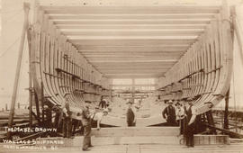
"The Mabel Brown" - Wallace Shipyards North Vancouver, B.C.
Part of Major Matthews collection
Photograph shows the hull under construction
!["The Mabel Brown" [under construction] - Wallace Shipyards North Vancouver, B.C.](/uploads/r/null/c/3/c3ec46e7947253c719c689422fcbb895d3f603574503c090f5377823c198207f/1d808834-1667-4ffc-92bd-90330084689b-A61318_142.jpg)
"The Mabel Brown" [under construction] - Wallace Shipyards North Vancouver, B.C.
Part of Major Matthews collection

"Mabel Brown" First Auxiliary Schooner Launched in B.C.
Part of Major Matthews collection
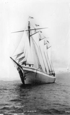
"Mabel Brown" First Auxiliary Schooner Launched in B.C.
Part of Major Matthews collection

Laying and Caulking Deck of "The Mabel Brown" - Wallace Shipyards North Vancouver, B.C.
Part of Major Matthews collection

Part of Major Matthews collection
Photograph shows The Lonsdale Theatre

Part of Major Matthews collection

North Vancouver Coal and Supply Company Limited
Part of Major Matthews collection
Photograph shows teamsters on their laden wagons and Brackman-Ker Milling Company
![[Exterior of the Palace Hotel on 2nd Street]](/uploads/r/null/a/3/a345a9cf0812a94831a0c30e79f1ff40ca0584eb946311e94c94482c70b9bf0c/3250694b-3c6c-40bf-9777-d86cc6fb9f55-A61046_142.jpg)
[Exterior of the Palace Hotel on 2nd Street]
Part of Major Matthews collection

Part of Major Matthews collection
![[An unidentified alpine club climbing a steep rise]](/uploads/r/null/c/9/c95c9c89fcd43d0904bbfe7a76c5cf27fd3e4df5e91e4c5093cece4c71512d82/2eaf7e5f-1644-4c71-8f91-33b8e7ddfb65-A60575_142.jpg)
[An unidentified alpine club climbing a steep rise]
Part of Major Matthews collection
Item is a photograph. Notes written on the back say " I think first ascent of North Shore Mountains by women of Alpine Club. I think we have 8x10 negative. JSM"
Part of Major Matthews collection
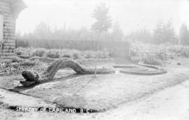
Photograph shows part of the whimsical garden at Napoleon St. Pierre's place in the 1500 Block of Marine Drive

The Great Mystery, Capilano Garden, B.C.
Part of Major Matthews collection
Photograph shows part of the whimsical garden at Napoleon St. Pierre's place in the 1500 Block of Marine Drive

Engineers in Camp North Vancouver
Part of Major Matthews collection
Group portrait showing soldiers building bridges at Fell's Fill at the foot of Fell Avenue

Engineers in Camp North Vancouver
Part of Major Matthews collection
Group portrait showing soldiers building bridges at Fell's Fill at the foot of Fell Avenue

Engineers in Camp North Vancouver
Part of Major Matthews collection
Group portrait showing soldiers at Fell's Fill at the foot of Fell Avenue and Major J. Eades Ward

Engineers in Camp North Vancouver
Part of Major Matthews collection
Photograph shows soldiers filling sandbags at Fell's Fill at the foot of Fell Avenue and Major J. Eades Ward

Swing Bridge Capilano Canyon, N. Vancouver, B.C.
Part of Major Matthews collection
Photograph shows the suspension bridge

Capilano Canyon Vancouver, B.C.
Part of Major Matthews collection
Photograph shows the Capilano Suspension Bridge
![First shack top Grouse Mountain [built by Fred Hickleton]](/uploads/r/null/d/e/de514a6acdc8f0fd86de247688c99aa3f9d372fe3ad94d2cc7b8db46f0a93174/8115cf2a-6623-4685-9c28-0d4729122c5f-A59776_142.jpg)
First shack top Grouse Mountain [built by Fred Hickleton]
Part of Major Matthews collection

Lynn Canyon, North Vancouver, B.C.
Part of Major Matthews collection

Part of Major Matthews collection
The item is a table of place names shown on map 56.01; Indian villages and landmarks, Burrard Inlet and English Bay, before the whiteman came. The table gives First Nations names and their approximate english meaning, or the European name given to the same location.
![[View of] Deep Cove](/uploads/r/null/a/4/8/a484633a9b322f7312e88c297a1c34d4f3b91a57d615bc2ca1fc7c8c7e2142d3/29df26d6-3948-431e-9d78-f51402604821-OutN216_142.jpg)
Part of Major Matthews collection
Photograph shows Hamber Island on the left and Boulder Island on the right

Part of Major Matthews collection
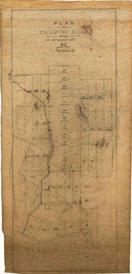
Plan of pre-emption claims, group 1, New Westminster District B.C., 1887-1888
Part of Major Matthews collection
Item is a map depicting pre-emption claims in Group 1, New Westminster District, a section of land extending north from Burrard Inlet and including Capilano Creek. The majority of claims are numbered and/or include the owner's last name. In addition to creeks, the map also shows the location of a waterworks dam, mountains, and high hills. Pencil annotations indicate the location of "Trythall's Clearing."
![[Water system at Burwell Lake]](/uploads/r/null/0/9/098465d125c4bd2b3cf419156cfe52e2602a2d92b214ed3218a2c75158a25ae1/a20d8fee-48b5-4df3-a31a-3bcffcf2d779-A09276_142.jpg)
[Water system at Burwell Lake]
Part of Major Matthews collection
![[Water system at Burwell Lake]](/uploads/r/null/a/2/a263f0649897b6ff16ebb080890f9330c6c9daff2421599741ba0876277e808d/b1842f99-ae5b-4fff-afd0-f4bf3fbb15c4-A09275_142.jpg)
[Water system at Burwell Lake]
Part of Major Matthews collection

Map of portion New Westminster District
Part of Major Matthews collection
Item is an annotated tracing of a map showing the future sites of Vancouver, Burnaby and the North Shore from an area bordering on English Bay to an area bordering on North Arm. Traced over by J.S. Matthews in 1954, it illustrates intended land settlement and subdivision in 1877. Also shown are bodies of water, Hastings & Granville Road, and the settlements of Hastings and Granville. Annotations are an introductory note by Matthews in August 1954 titled "Before Greater Vancouver." Enclosed with the map are four letters between J.S. Matthews and W.H. Hutchinson, Chief of the Geographic Division of the B.C. Survey and Mapping Branch of the Department of Lands and Forests, in 1954 concerning the map's provenance and Matthew's efforts to increase the legibility of copies of the original map.
![[Group portrait Boy Scouts, North Vancouver parade]](/uploads/r/null/1/4/143f3f5255631361d88edacb9e5c754165f9f6bdf2708adb705e9a4ca13ebf3d/bc5723a7-9530-4b78-837d-e16c3364a381-A63420_142.jpg)
[Group portrait Boy Scouts, North Vancouver parade]
Part of Major Matthews collection

Part of Major Matthews collection
Photograph shows The Lions in the background
![[Unidentified group docked at Pete Larson's wharf]](/uploads/r/null/7/4/74897d326eed1339b23c0dbfd0e7d0eba8bcd2aa7c9e256a03883fca7cce7072/1d5848ad-69d6-4315-96cc-cd395e441f4d-A62157_142.jpg)
[Unidentified group docked at Pete Larson's wharf]
Part of Major Matthews collection
![[Group portrait of employees in front of Wallace Shipyards Ltd.]](/uploads/r/null/a/4/a4c82fb555aa433ee21463634232ecda705297e45e53bd4a001e68745c85e505/ad77ffb1-c3f9-48e8-b19b-5ee728d1f5ac-A63950_142.jpg)
[Group portrait of employees in front of Wallace Shipyards Ltd.]
Part of Major Matthews collection
![[Two views of Walsh Construction Company and Vancouver Lumber Company, Roche Point]](/uploads/r/null/0/1/013502406fee6f1750799b504583387029434af1a7a6b486a849aff5ceed3584/8a0b0f30-1518-43f4-ab43-a7c0fca56ee1-A63951_142.jpg)
[Two views of Walsh Construction Company and Vancouver Lumber Company, Roche Point]
Part of Major Matthews collection
![[View of Walsh Construction Company and Vancouver Lumber Company, Roche Point]](/uploads/r/null/7/4/74a291b4c22874f372bf133bdf98c42fbe97ed4e46a76bdc028f47b03b626232/f6326306-0c84-439d-9187-00515300be58-A63952_142.jpg)
[View of Walsh Construction Company and Vancouver Lumber Company, Roche Point]
Part of Major Matthews collection
![[View of Walsh Construction Company and Vancouver Lumber Company, Roche Point]](/uploads/r/null/8/3/83ae4c0fb4fcad696b71d6d9f6361b96a0a28f37adcfc45442a1ba095959a7ea/fd6512ec-687a-4948-9fc5-ca4084e8da67-A63945_142.jpg)
[View of Walsh Construction Company and Vancouver Lumber Company, Roche Point]
Part of Major Matthews collection